Glenside neighborhood in Reading, Pennsylvania (PA), 19601, 19605, 19610 detailed profile
Settings
X


Business Search - 14 Million verified businesses
Area: 2.303 square miles
Population: 13,250
Population density:
| Glenside: | 5,753 people per square mile |
| Reading: | 9,661 people per square mile |

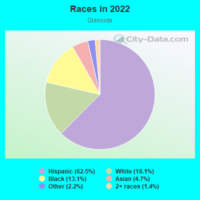
- 8,87162.5%Hispanic or Latino
- 2,29116.1%White
- 1,85513.1%Black
- 6644.7%Asian
- 3092.2%Some other race
- 2021.4%Two or more races
Median household income in 2022:
| Glenside: | $48,693 |
| Reading: | $43,496 |
Distribution of median household income
![Distribution of median household income]()
- 924Less than $10,000
- 863$10,000 to $19,999
- 806$20,000 to $29,999
- 301$30,000 to $39,999
- 594$40,000 to $49,999
- 356$50,000 to $59,999
- 531$60,000 to $74,999
- 343$75,000 to $99,999
- 250$100,000 to $124,999
- 75$125,000 to $149,999
- 261$150,000 to $199,999
- 96$200,000 or more

Distribution of owner-occupied house/condo value
![Distribution of owner-occupied house/condo value]()
- 2,405Less than $50,000
- 1,125$50,000 to $99,999
- 542$100,000 to $149,999
- 434$150,000 to $199,999
- 248$200,000 to $249,999
- 59$250,000 to $299,999
- 131$300,000 to $399,999
- 43$400,000 to $499,999
- 88$500,000 to $749,999
- 18$750,000 to $999,999
- 113$1,000,000 or more

Distribution of rent paid by renters
![Distribution of rent paid by renters]()
- 328Less than $100
- 750$100 to $199
- 1,026$200 to $299
- 665$300 to $399
- 847$400 to $499
- 525$500 to $599
- 355$600 to $699
- 539$700 to $799
- 482$800 to $899
- 442$900 to $999
- 513$1,000 to $1,249
- 250$1,250 to $1,499
- 323$1,500 to $1,999
- 27$2,000 or more

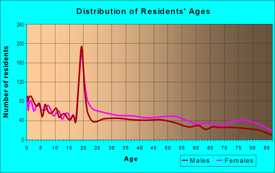
| Males: | 6,012 |
| Females: | 7,238 |
Males:
| This neighborhood: | 36.5 years |
| Whole city: | 32.1 years |
| This neighborhood: | 41.3 years |
| Whole city: | 31.8 years |
Average household size:
| Glenside: | 8.5 people |
| Reading: | 2.8 people |
Percentage of family households:
| Glenside: | 49.8% |
| Reading: | 48.4% |
| Here: | 28.3% |
| Reading: | 26.1% |
Percentage of married-couple families with children (among all households):
| Glenside: | 12.7% |
| Reading: | 11.0% |
Percentage of single-mother households (among all households):
| Glenside: | 20.2% |
| Reading: | 18.7% |
Percentage of never married males 15 years old and over:
Percentage of never married females 15 years old and over:
| Glenside: | 23.6% |
| Reading: | 24.6% |
Percentage of never married females 15 years old and over:
| Glenside: | 25.9% |
| city: | 25.9% |
Percentage of people that speak English not well or not at all:
| Glenside: | 12.7% |
| Reading: | 15.5% |
Percentage of people born in this state:
Percentage of people born in another U.S. state:
Percentage of native residents but born outside the U.S.:
Percentage of foreign born residents:
| Here: | 47.7% |
| Reading: | 43.0% |
Percentage of people born in another U.S. state:
| Glenside: | 17.8% |
| Reading: | 18.5% |
Percentage of native residents but born outside the U.S.:
| Here: | 20.8% |
| city: | 15.9% |
Percentage of foreign born residents:
| Here: | 13.7% |
| Reading: | 22.7% |
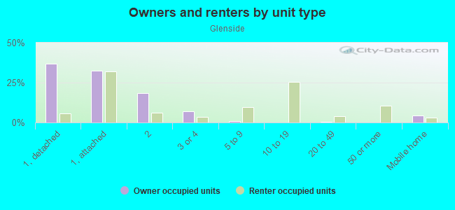
Owner-occupied
Renter-occupied

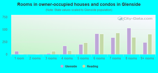
- Rooms in owner-occupied houses and condos in Glenside
- 661 room
- 02 rooms
- 203 rooms
- 1704 rooms
- 2005 rooms
- 4156 rooms
- 3377 rooms
- 5298 rooms
- 2409+ rooms
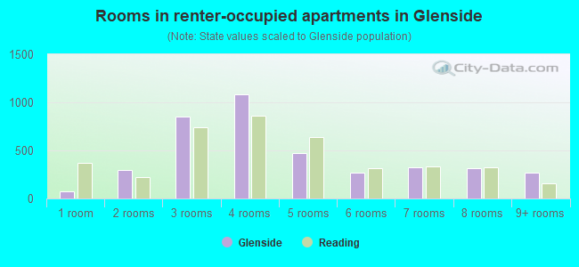
- Rooms in renter-occupied apartments in Glenside
- 771 room
- 2942 rooms
- 8543 rooms
- 1,0864 rooms
- 4765 rooms
- 2726 rooms
- 3237 rooms
- 3158 rooms
- 2729+ rooms
Owner-occupied
Renter-occupied
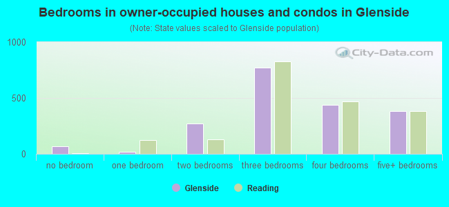
- Bedrooms in owner-occupied houses and condos in Glenside
- 66no bedroom
- 201 bedroom
- 2702 bedrooms
- 7713 bedrooms
- 4364 bedrooms
- 3835+ bedrooms
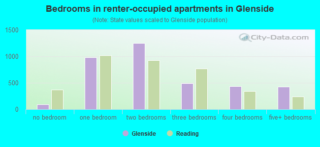
- Bedrooms in renter-occupied apartments in Glenside
- 94no bedroom
- 9771 bedroom
- 1,2462 bedrooms
- 4913 bedrooms
- 4324 bedrooms
- 4235+ bedrooms
Average number of cars or other vehicles available in houses/condos:
Average number of cars or other vehicles available in apartments:
| This neighborhood: | 1.8 |
| Reading: | 1.7 |
Average number of cars or other vehicles available in apartments:
| Here: | 1.1 |
| city: | 1.0 |
Percentage of units with a mortgage:
| Glenside: | 54.1% |
| Reading: | 52.3% |
Average estimated value of townhouses or other attached units in 2022 (42.1% of all units):
| This neighborhood: | $70,335 |
| city: | $88,387 |
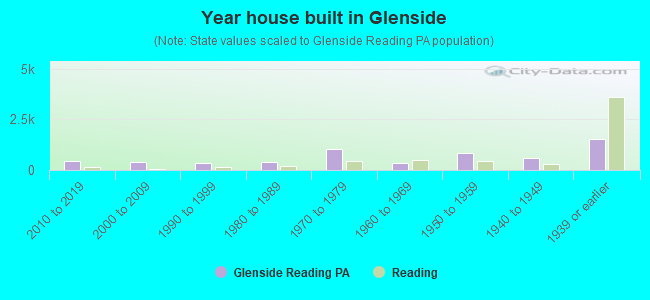
- Year house built in Glenside
- 202020 or later
- 4262010 to 2019
- 3932000 to 2009
- 3501990 to 1999
- 3771980 to 1989
- 1,0311970 to 1979
- 3621960 to 1969
- 8371950 to 1959
- 5931940 to 1949
- 1,5241939 or earlier
City-data.com crime index for city in 2020 (higher means more crime):
| City: | 127.5 |
| U.S. average: | 219.5 |
Travel time to work (commute)
![Travel time to work (commute)]()
- 111Less than 5 minutes
- 3525 to 9 minutes
- 1,02310 to 14 minutes
- 82515 to 19 minutes
- 71820 to 24 minutes
- 48525 to 29 minutes
- 58530 to 34 minutes
- 23035 to 39 minutes
- 21940 to 44 minutes
- 20445 to 59 minutes
- 21660 to 89 minutes
- 9990 or more minutes

Means of transportation to work
![Means of transportation to work]()
- 66.8%2,987Drove a car alone
- 20.0%894Carpooled
- 10.4%466Bus
- 29.3%1,308Taxi
- 4.4%198Walked
- 8.6%385Other means
- 1.8%80Worked at home

Time leaving home to go to work
![Time leaving home to go to work]()
- 69512:00 a.m. to 4:59 a.m.
- 2115:00 a.m. to 5:29 a.m.
- 4825:30 a.m. to 5:59 a.m.
- 6126:00 a.m. to 6:29 a.m.
- 3786:30 a.m. to 6:59 a.m.
- 3347:00 a.m. to 7:29 a.m.
- 2647:30 a.m. to 7:59 a.m.
- 3758:00 a.m. to 8:29 a.m.
- 1138:30 a.m. to 8:59 a.m.
- 1549:00 a.m. to 9:59 a.m.
- 19810:00 a.m. to 10:59 a.m.
- 10011:00 a.m. to 11:59 a.m.
- 60712:00 p.m. to 3:59 p.m.
- 6154:00 p.m. to 11:59 p.m.

Occupations of males:
- Percentage of males in management occupations (except farmers):
Here: 1.8% city: 4.8%
- Percentage of males in computer and mathematical occupations:
Here: 2.2% city: 0.8%
- Percentage of males in community and social services occupations:
Here: 3.6% city: 1.2%
- Percentage of males in education, training, and library occupations:
Here: 4.2% city: 1.8%
- Percentage of males in service occupations:
Here: 20.7% city: 17.8%
- Percentage of males in sales and office occupations:
Here: 14.9% city: 12.9%
- Percentage of males in farming, fishing, and forestry occupations:
Here: 7.7% city: 4.1%
- Percentage of males in construction, extraction, and maintenance occupations:
Here: 6.8% city: 6.2%
- Percentage of males in production occupations:
Here: 14.5% city: 20.3%
- Percentage of males in transportation occupations:
Here: 3.7% city: 7.1%
- Percentage of males in material moving occupations:
Here: 12.7% city: 13.8%
Occupations of females:
- Percentage of females in management occupations (except farmers):
Here: 1.8% city: 3.1%
- Percentage of females in business and financial operations occupations:
Here: 1.2% city: 2.1%
- Percentage of females in computer and mathematical occupations:
Here: 1.0% city: 0.6%
- Percentage of females in life, physical, and social science occupations:
Here: 1.2% city: 0.5%
- Percentage of females in community and social services occupations:
Here: 3.0% city: 4.8%
- Percentage of females in education, training, and library occupations:
Here: 5.4% city: 5.1%
- Percentage of females in healthcare practitioners and technical occupations:
Here: 2.9% city: 5.2%
- Percentage of females in service occupations:
Here: 36.2% city: 28.9%
- Percentage of females in sales and office occupations:
Here: 18.9% city: 23.3%
- Percentage of females in production occupations:
Here: 21.0% city: 13.3%
- Percentage of females in material moving occupations:
Here: 6.9% city: 7.5%
Percentage of people 16-64 in Armed Forces:
| Glenside: | 0.1% |
| Reading: | 0.1% |
Education in this neighborhood (subdivision or community):
- Percentage of people 3 years and older in K-12 schools:
Glenside: 32.8% Reading: 22.3%
- Percentage of people 3 years and older in undergraduate colleges:
Glenside: 5.3% Reading: 4.8%
- Percentage of people 3 years and older in grad. or professional schools:
Glenside: 8.2% Reading: 0.4%
- Percentage of students K-12 enrolled in private schools:
Glenside: 25.8% Reading: 7.0%
Percentage of population below poverty level:
| Glenside: | 31.0% |
| Reading: | 26.8% |
Median year owner moved in (as recorded in 2022):
| Glenside: | 2008 |
| Reading: | 2009 |
Percentage of married-couple families with both working:
| Glenside: | 94.5% |
| Reading: | 64.6% |
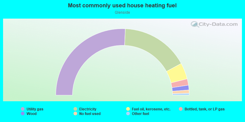
- 51.4%Utility gas
- 32.9%Electricity
- 7.9%Fuel oil, kerosene, etc.
- 3.1%Bottled, tank, or LP gas
- 2.3%Wood
- 1.6%No fuel used
- 0.9%Other fuel
Limited-access highways (interstate or state) in this neighborhood:
Warren St Byp
Length: 2.33 miles
Directions: E-W, N-S, SW-NE
Address range: 1 to 899
Directions: E-W, N-S, SW-NE
Address range: 1 to 899
Highways in this neighborhood:
Schuylkill Ave (State Rte 183)
Length: 1.15 miles
Direction: SE-NW
Address range: 650 to 1554
Direction: SE-NW
Address range: 650 to 1554
US Hwy 422 (US Hwy 222, W Shore Byp)
Length: 0.76 miles
Directions: E-W, N-S, SE-NW
Directions: E-W, N-S, SE-NW
State Rte 183 (Bernville Rd)
Length: 0.38 miles
Direction: SE-NW
Address range: 1600 to 1899
Direction: SE-NW
Address range: 1600 to 1899
US Hwy 222
Length: 0.29 miles
Directions: E-W, SE-NW
Directions: E-W, SE-NW
Roads and streets:
River Rd
Length: 1.36 miles
Directions: E-W, SE-NW, SW-NE
Address range: 901 to 2499
Directions: E-W, SE-NW, SW-NE
Address range: 901 to 2499
Lehigh St
Length: 0.98 miles
Directions: N-S, SE-NW, SW-NE
Address range: 1 to 999
Directions: N-S, SE-NW, SW-NE
Address range: 1 to 999
Mercer St
Length: 0.91 miles
Directions: E-W, SE-NW, SW-NE
Address range: 1 to 799
Directions: E-W, SE-NW, SW-NE
Address range: 1 to 799
Cartech Rd
Length: 0.85 miles
Directions: E-W, N-S, SW-NE
Address range: 6 to 8
Directions: E-W, N-S, SW-NE
Address range: 6 to 8
Lackawanna St
Length: 0.83 miles
Directions: E-W, SW-NE
Address range: 2 to 1098
Directions: E-W, SW-NE
Address range: 2 to 1098
N Front St
Length: 0.82 miles
Directions: N-S, SW-NE
Address range: 1300 to 2020
Directions: N-S, SW-NE
Address range: 1300 to 2020
Chester St
Length: 0.73 miles
Directions: SE-NW, SW-NE
Address range: 1100 to 1553
Directions: SE-NW, SW-NE
Address range: 1100 to 1553
Tulpehocken Rd
Length: 0.67 miles
Directions: E-W, N-S, SE-NW
Address range: 1700 to 2199
Directions: E-W, N-S, SE-NW
Address range: 1700 to 2199
Columbia Ave
Length: 0.66 miles
Directions: SE-NW, SW-NE
Address range: 100 to 1199
Directions: SE-NW, SW-NE
Address range: 100 to 1199
Luzerne St
Length: 0.65 miles
Directions: E-W, N-S, SE-NW, SW-NE
Address range: 1102 to 1599
Directions: E-W, N-S, SE-NW, SW-NE
Address range: 1102 to 1599
Green Ln
Length: 0.63 miles
Directions: E-W, N-S, SE-NW, SW-NE
Address range: 301 to 416
Directions: E-W, N-S, SE-NW, SW-NE
Address range: 301 to 416
Blair Ave
Length: 0.62 miles
Directions: N-S, SW-NE
Address range: 1 to 499
Directions: N-S, SW-NE
Address range: 1 to 499
Berkley Rd
Length: 0.61 miles
Direction: E-W
Address range: 2200 to 2498
Direction: E-W
Address range: 2200 to 2498
Carbon St
Length: 0.60 miles
Direction: SE-NW
Address range: 1100 to 1599
Direction: SE-NW
Address range: 1100 to 1599
Butler St
Length: 0.60 miles
Direction: SE-NW
Address range: 1102 to 1599
Direction: SE-NW
Address range: 1102 to 1599
Wayne St
Length: 0.52 miles
Direction: SE-NW
Address range: 1200 to 1499
Direction: SE-NW
Address range: 1200 to 1499
Clarion St
Length: 0.50 miles
Directions: N-S, SE-NW, SW-NE
Address range: 1102 to 1499
Directions: N-S, SE-NW, SW-NE
Address range: 1102 to 1499
Allegheny Ave
Length: 0.49 miles
Direction: SE-NW
Address range: 1102 to 1599
Direction: SE-NW
Address range: 1102 to 1599
Golf Rd
Length: 0.44 miles
Directions: E-W, N-S, SE-NW, SW-NE
Address range: 1600 to 1799
Directions: E-W, N-S, SE-NW, SW-NE
Address range: 1600 to 1799
Warren St
Length: 0.43 miles
Directions: E-W, N-S, SW-NE
Address range: 600 to 899
Directions: E-W, N-S, SW-NE
Address range: 600 to 899
S Tulpehocken Rd
Length: 0.42 miles
Directions: E-W, N-S, SW-NE
Address range: 300 to 417
Directions: E-W, N-S, SW-NE
Address range: 300 to 417
Miltimore St
Length: 0.39 miles
Direction: SE-NW
Address range: 624 to 998
Direction: SE-NW
Address range: 624 to 998
Gordon St
Length: 0.39 miles
Direction: SE-NW
Address range: 624 to 999
Direction: SE-NW
Address range: 624 to 999
N Tulpehocken Rd
Length: 0.39 miles
Directions: E-W, SW-NE
Address range: 307 to 499
Directions: E-W, SW-NE
Address range: 307 to 499
Clinton St
Length: 0.38 miles
Direction: SE-NW
Address range: 616 to 898
Direction: SE-NW
Address range: 616 to 898
Parliament Dr
Length: 0.38 miles
Directions: E-W, N-S, SW-NE
Directions: E-W, N-S, SW-NE
Ave B
Length: 0.38 miles
Directions: N-S, SW-NE
Address range: 500 to 799
Directions: N-S, SW-NE
Address range: 500 to 799
Ave A
Length: 0.36 miles
Direction: SW-NE
Address range: 500 to 899
Direction: SW-NE
Address range: 500 to 899
W Douglass St
Length: 0.36 miles
Direction: E-W
Address range: 300 to 599
Direction: E-W
Address range: 300 to 599
Monroe St
Length: 0.35 miles
Direction: SE-NW
Address range: 1150 to 1430
Direction: SE-NW
Address range: 1150 to 1430
Berkshire Dr
Length: 0.35 miles
Direction: E-W
Address range: 800 to 999
Direction: E-W
Address range: 800 to 999
Woodward Dr
Length: 0.35 miles
Directions: E-W, N-S, SW-NE
Address range: 800 to 906
Directions: E-W, N-S, SW-NE
Address range: 800 to 906
W Windsor St
Length: 0.30 miles
Direction: E-W
Address range: 300 to 499
Direction: E-W
Address range: 300 to 499
W Oley St
Length: 0.30 miles
Direction: E-W
Address range: 300 to 599
Direction: E-W
Address range: 300 to 599
Mc Knight St
Length: 0.29 miles
Direction: N-S
Address range: 1600 to 1799
Direction: N-S
Address range: 1600 to 1799
W Perry St
Length: 0.27 miles
Directions: E-W, N-S
Address range: 151 to 172
Directions: E-W, N-S
Address range: 151 to 172
Eckert St
Length: 0.27 miles
Directions: E-W, N-S
Address range: 1 to 150
Directions: E-W, N-S
Address range: 1 to 150
N 4th St
Length: 0.26 miles
Direction: N-S
Address range: 601 to 822
Direction: N-S
Address range: 601 to 822
Tulpehocken St
Length: 0.24 miles
Direction: SE-NW
Address range: 622 to 799
Direction: SE-NW
Address range: 622 to 799
Douglass St
Length: 0.24 miles
Direction: E-W
Address range: 300 to 498
Direction: E-W
Address range: 300 to 498
N Wyomissing Blvd
Length: 0.24 miles
Direction: E-W
Address range: 100 to 399
Direction: E-W
Address range: 100 to 399
George St
Length: 0.24 miles
Directions: E-W, SE-NW, SW-NE
Address range: 800 to 899
Directions: E-W, SE-NW, SW-NE
Address range: 800 to 899
W Robeson St
Length: 0.23 miles
Directions: E-W, SW-NE
Directions: E-W, SW-NE
W Spring St
Length: 0.22 miles
Direction: E-W
Address range: 200 to 299
Direction: E-W
Address range: 200 to 299
Greenview Ave
Length: 0.22 miles
Directions: E-W, SE-NW
Address range: 1400 to 1524
Directions: E-W, SE-NW
Address range: 1400 to 1524
W Cartech Rd
Length: 0.22 miles
Directions: E-W, N-S, SW-NE
Directions: E-W, N-S, SW-NE
Lincoln St
Length: 0.21 miles
Direction: N-S
Address range: 670 to 773
Direction: N-S
Address range: 670 to 773
Weiser St
Length: 0.20 miles
Direction: N-S
Address range: 1000 to 1099
Direction: N-S
Address range: 1000 to 1099
Windsor St
Length: 0.19 miles
Direction: E-W
Address range: 300 to 499
Direction: E-W
Address range: 300 to 499
Sunshine Rd
Length: 0.19 miles
Direction: SE-NW
Address range: 300 to 313
Direction: SE-NW
Address range: 300 to 313
Eisenbrown St
Length: 0.18 miles
Direction: SE-NW
Address range: 616 to 699
Direction: SE-NW
Address range: 616 to 699
Downing St
Length: 0.18 miles
Direction: E-W
Address range: 2100 to 2299
Direction: E-W
Address range: 2100 to 2299
Greenwich St
Length: 0.17 miles
Direction: E-W
Address range: 317 to 399
Direction: E-W
Address range: 317 to 399
Argonne Rd
Length: 0.16 miles
Directions: E-W, SE-NW
Address range: 1500 to 1599
Directions: E-W, SE-NW
Address range: 1500 to 1599
Kissinger Ln
Length: 0.16 miles
Direction: SW-NE
Direction: SW-NE
Darien St
Length: 0.15 miles
Direction: SE-NW
Address range: 1500 to 1599
Direction: SE-NW
Address range: 1500 to 1599
Allison Rd
Length: 0.15 miles
Directions: E-W, N-S, SW-NE
Address range: 1 to 11
Directions: E-W, N-S, SW-NE
Address range: 1 to 11
Colston St (Colston Ave)
Length: 0.15 miles
Direction: SW-NE
Address range: 1 to 199
Direction: SW-NE
Address range: 1 to 199
Denton St
Length: 0.14 miles
Direction: N-S
Address range: 1 to 123
Direction: N-S
Address range: 1 to 123
Heather Ln
Length: 0.13 miles
Directions: N-S, SE-NW
Address range: 1 to 1710
Directions: N-S, SE-NW
Address range: 1 to 1710
Snyder St
Length: 0.13 miles
Direction: SE-NW
Address range: 1500 to 1599
Direction: SE-NW
Address range: 1500 to 1599
W Berton St
Length: 0.13 miles
Directions: E-W, SW-NE
Address range: 1 to 99
Directions: E-W, SW-NE
Address range: 1 to 99
Oley St
Length: 0.12 miles
Direction: E-W
Address range: 300 to 399
Direction: E-W
Address range: 300 to 399
Erie St
Length: 0.12 miles
Direction: SW-NE
Address range: 100 to 199
Direction: SW-NE
Address range: 100 to 199
Ave D
Length: 0.12 miles
Direction: SE-NW
Address range: 1200 to 1399
Direction: SE-NW
Address range: 1200 to 1399
Ave C
Length: 0.12 miles
Direction: SE-NW
Address range: 1200 to 1399
Direction: SE-NW
Address range: 1200 to 1399
Tully Ln
Length: 0.12 miles
Directions: E-W, SW-NE
Address range: 1 to 99
Directions: E-W, SW-NE
Address range: 1 to 99
N Park Rd
Length: 0.12 miles
Directions: N-S, SE-NW
Address range: 709 to 829
Directions: N-S, SE-NW
Address range: 709 to 829
Pike St
Length: 0.11 miles
Directions: E-W, N-S
Address range: 100 to 199
Directions: E-W, N-S
Address range: 100 to 199
Kathryn St
Length: 0.11 miles
Direction: SW-NE
Address range: 600 to 699
Direction: SW-NE
Address range: 600 to 699
Kissinger Ln (Berkshire Blvd)
Length: 0.10 miles
Directions: N-S, SW-NE
Directions: N-S, SW-NE
Bridge St
Length: 0.10 miles
Direction: E-W
Address range: 300 to 399
Direction: E-W
Address range: 300 to 399
Wendy Rd
Length: 0.10 miles
Direction: E-W
Direction: E-W
Hollenbach St
Length: 0.09 miles
Direction: E-W
Address range: 300 to 399
Direction: E-W
Address range: 300 to 399
Resh Ave
Length: 0.09 miles
Directions: N-S, SW-NE
Directions: N-S, SW-NE
Eastman St
Length: 0.09 miles
Direction: SE-NW
Address range: 2 to 96
Direction: SE-NW
Address range: 2 to 96
Ashton St
Length: 0.08 miles
Direction: SW-NE
Address range: 1 to 99
Direction: SW-NE
Address range: 1 to 99
W Bern St
Length: 0.08 miles
Direction: E-W
Address range: 148 to 199
Direction: E-W
Address range: 148 to 199
Elkton St
Length: 0.08 miles
Direction: N-S
Address range: 1 to 50
Direction: N-S
Address range: 1 to 50
McKnight St
Length: 0.08 miles
Direction: N-S
Direction: N-S
W Union St
Length: 0.08 miles
Direction: E-W
Direction: E-W
Potter St
Length: 0.07 miles
Direction: SW-NE
Address range: 1 to 99
Direction: SW-NE
Address range: 1 to 99
Eastman Rd
Length: 0.07 miles
Direction: SE-NW
Direction: SE-NW
Lahoma Rd
Length: 0.06 miles
Direction: SW-NE
Address range: 202 to 210
Direction: SW-NE
Address range: 202 to 210
Howard Pl
Length: 0.06 miles
Direction: E-W
Address range: 1300 to 1333
Direction: E-W
Address range: 1300 to 1333
Baer St
Length: 0.05 miles
Direction: E-W
Address range: 750 to 799
Direction: E-W
Address range: 750 to 799
W Amity St
Length: 0.04 miles
Direction: E-W
Address range: 100 to 199
Direction: E-W
Address range: 100 to 199
W Exeter St
Length: 0.04 miles
Direction: E-W
Direction: E-W
Poplar Rd
Length: 0.02 miles
Direction: SE-NW
Direction: SE-NW
Railroad features:
Conrail RR
Length: 4.73 miles
Directions: E-W, N-S, SE-NW, SW-NE
Directions: E-W, N-S, SE-NW, SW-NE
Norfolk Southern Corporation
Length: 0.13 miles
Directions: E-W, N-S, SW-NE
Directions: E-W, N-S, SW-NE
Other features:
Schuylkill Riv
Length: 0.88 miles
Directions: E-W, N-S, SE-NW, SW-NE
Directions: E-W, N-S, SE-NW, SW-NE
Tulpehocken Crk
Length: 0.79 miles
Directions: N-S, SE-NW, SW-NE
Directions: N-S, SE-NW, SW-NE
Other features:
Montgomery St
Length: 0.72 miles
Directions: E-W, SE-NW
Address range: 1100 to 1545
Directions: E-W, SE-NW
Address range: 1100 to 1545