Greater Near North neighborhood in Minneapolis, Minnesota (MN), 55405, 55411 detailed profile
Settings
X

Business Search - 14 Million verified businesses
Area: 4.602 square miles
Population: 41,964
Population density:
| Greater Near North: | 9,118 people per square mile |
| Minneapolis: | 7,744 people per square mile |

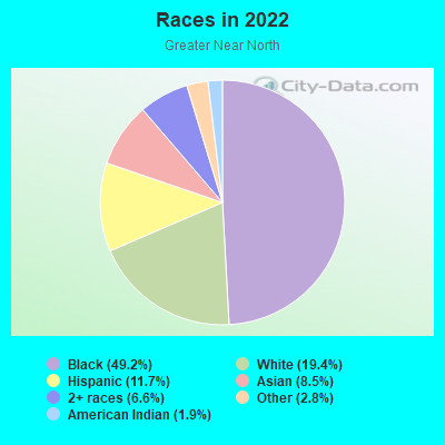
- 21,95249.2%Black
- 8,66419.4%White
- 5,22611.7%Hispanic or Latino
- 3,7878.5%Asian
- 2,9326.6%Two or more races
- 1,2552.8%Some other race
- 8391.9%American Indian
Distribution of median household income
![Distribution of median household income]()
- 1,822Less than $10,000
- 2,439$10,000 to $19,999
- 2,231$20,000 to $29,999
- 1,868$30,000 to $39,999
- 1,819$40,000 to $49,999
- 1,117$50,000 to $59,999
- 1,236$60,000 to $74,999
- 1,630$75,000 to $99,999
- 1,793$100,000 to $124,999
- 864$125,000 to $149,999
- 620$150,000 to $199,999
- 1,064$200,000 or more

Distribution of owner-occupied house/condo value
![Distribution of owner-occupied house/condo value]()
- 4,245Less than $50,000
- 4,477$50,000 to $99,999
- 1,139$100,000 to $149,999
- 1,741$150,000 to $199,999
- 1,790$200,000 to $249,999
- 1,684$250,000 to $299,999
- 1,033$300,000 to $399,999
- 763$400,000 to $499,999
- 313$500,000 to $749,999
- 243$750,000 to $999,999
- 3,653$1,000,000 or more

Distribution of rent paid by renters
![Distribution of rent paid by renters]()
- 984Less than $100
- 2,068$100 to $199
- 2,190$200 to $299
- 1,723$300 to $399
- 1,788$400 to $499
- 1,481$500 to $599
- 2,097$600 to $699
- 1,872$700 to $799
- 984$800 to $899
- 821$900 to $999
- 1,267$1,000 to $1,249
- 1,354$1,250 to $1,499
- 1,074$1,500 to $1,999
- 1,285$2,000 or more

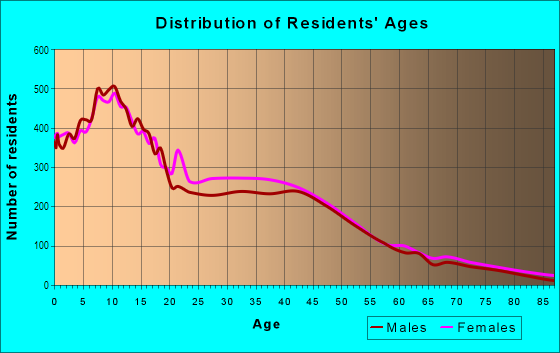
| Males: | 20,655 |
| Females: | 21,309 |
Males:
| This neighborhood: | |
| Whole city: |
| This neighborhood: | |
| Whole city: |
Percentage of family households:
| Greater Near North: | 47.9% |
| Minneapolis: | 34.1% |
| Here: | 24.2% |
| Minneapolis: | 29.8% |
Percentage of married-couple families with children (among all households):
| Greater Near North: | 18.0% |
| Minneapolis: | 31.8% |
Percentage of single-mother households (among all households):
| Greater Near North: | 18.1% |
| Minneapolis: | 10.5% |
Percentage of never married males 15 years old and over:
Percentage of never married females 15 years old and over:
| Greater Near North: | 28.8% |
| Minneapolis: | 27.0% |
Percentage of never married females 15 years old and over:
| Greater Near North: | 25.4% |
| city: | 25.4% |
Percentage of people that speak English not well or not at all:
| Greater Near North: | 6.8% |
| Minneapolis: | 3.8% |
Percentage of people born in this state:
Percentage of people born in another U.S. state:
Percentage of native residents but born outside the U.S.:
Percentage of foreign born residents:
| Here: | 49.2% |
| Minneapolis: | 51.9% |
Percentage of people born in another U.S. state:
| Greater Near North: | 29.2% |
| Minneapolis: | 31.8% |
Percentage of native residents but born outside the U.S.:
| Here: | 2.0% |
| city: | 1.5% |
Percentage of foreign born residents:
| Here: | 19.8% |
| Minneapolis: | 14.7% |
Owner-occupied
Renter-occupied

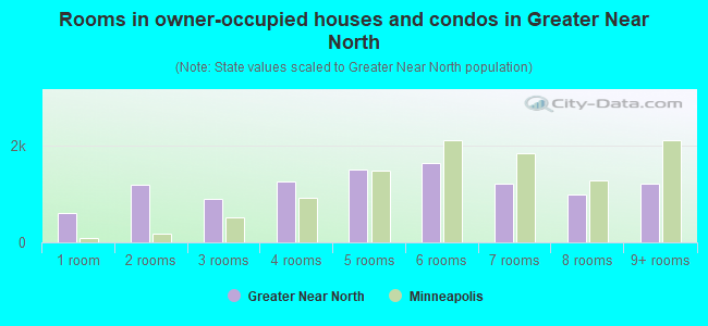
- Rooms in owner-occupied houses and condos in Greater Near North
- 6081 room
- 1,1902 rooms
- 9033 rooms
- 1,2724 rooms
- 1,5125 rooms
- 1,6496 rooms
- 1,2147 rooms
- 9928 rooms
- 1,2119+ rooms
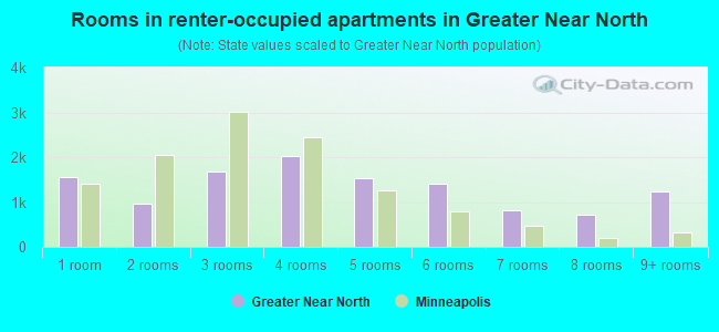
- Rooms in renter-occupied apartments in Greater Near North
- 1,5521 room
- 9662 rooms
- 1,6893 rooms
- 2,0374 rooms
- 1,5295 rooms
- 1,4126 rooms
- 8227 rooms
- 7198 rooms
- 1,2359+ rooms
Owner-occupied
Renter-occupied
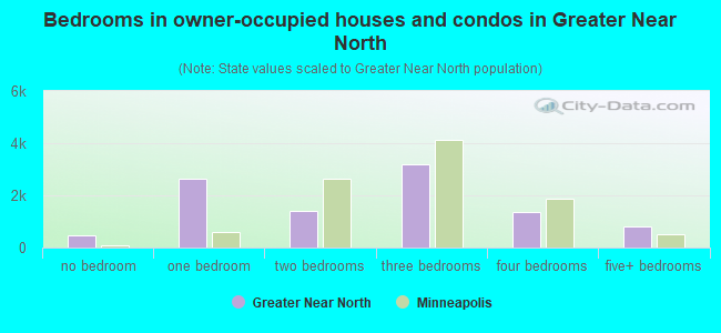
- Bedrooms in owner-occupied houses and condos in Greater Near North
- 453no bedroom
- 2,6221 bedroom
- 1,4252 bedrooms
- 3,1743 bedrooms
- 1,3694 bedrooms
- 8125+ bedrooms
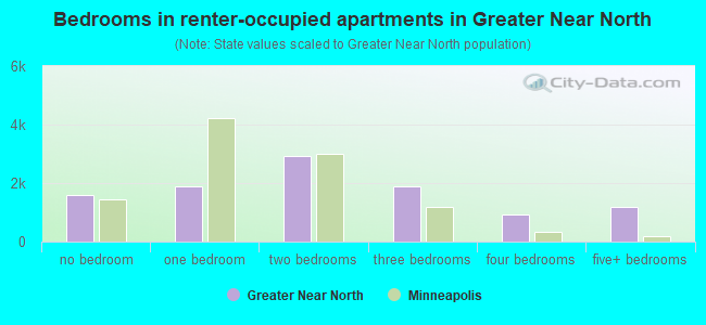
- Bedrooms in renter-occupied apartments in Greater Near North
- 1,578no bedroom
- 1,8981 bedroom
- 2,9182 bedrooms
- 1,8763 bedrooms
- 9324 bedrooms
- 1,1825+ bedrooms
Average number of cars or other vehicles available in houses/condos:
Average number of cars or other vehicles available in apartments:
| This neighborhood: | |
| Minneapolis: |
Average number of cars or other vehicles available in apartments:
| Here: | |
| city: |
Percentage of units with a mortgage:
| Greater Near North: | 77.0% |
| Minneapolis: | 71.8% |
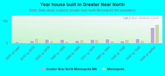
- Year house built in Greater Near North
- 6292020 or later
- 1,0892010 to 2019
- 1,7082000 to 2009
- 1,6481990 to 1999
- 1,1261980 to 1989
- 1,5901970 to 1979
- 1,8401960 to 1969
- 9001950 to 1959
- 1,9761940 to 1949
- 7,1021939 or earlier
City-data.com crime index for city in 2020 (higher means more crime):
| City: | 600.2 |
| U.S. average: | 219.5 |
Travel time to work (commute)
![Travel time to work (commute)]()
- 288Less than 5 minutes
- 6505 to 9 minutes
- 2,00710 to 14 minutes
- 3,16115 to 19 minutes
- 3,04020 to 24 minutes
- 1,05325 to 29 minutes
- 2,11130 to 34 minutes
- 66935 to 39 minutes
- 49840 to 44 minutes
- 1,32145 to 59 minutes
- 73160 to 89 minutes
- 37290 or more minutes

Means of transportation to work
![Means of transportation to work]()
- 60.9%10,711Drove a car alone
- 11.9%2,094Carpooled
- 12.1%2,134Bus
- 3.2%571Light rail, streetcar or trolley
- 2.2%383Taxi
- 2.0%359Motorcycle
- 2.6%463Bicycle
- 6.1%1,069Walked
- 3.9%686Other means
- 12.2%2,150Worked at home

Time leaving home to go to work
![Time leaving home to go to work]()
- 83412:00 a.m. to 4:59 a.m.
- 5595:00 a.m. to 5:29 a.m.
- 5765:30 a.m. to 5:59 a.m.
- 1,1516:00 a.m. to 6:29 a.m.
- 8826:30 a.m. to 6:59 a.m.
- 1,7137:00 a.m. to 7:29 a.m.
- 1,5987:30 a.m. to 7:59 a.m.
- 1,7438:00 a.m. to 8:29 a.m.
- 1,0688:30 a.m. to 8:59 a.m.
- 9299:00 a.m. to 9:59 a.m.
- 57310:00 a.m. to 10:59 a.m.
- 35411:00 a.m. to 11:59 a.m.
- 2,41212:00 p.m. to 3:59 p.m.
- 1,2464:00 p.m. to 11:59 p.m.

Occupations of males:
- Percentage of males in management occupations (except farmers):
Here: 9.9% city: 12.1%
- Percentage of males in business and financial operations occupations:
Here: 5.2% city: 9.1%
- Percentage of males in computer and mathematical occupations:
Here: 5.4% city: 8.4%
- Percentage of males in architecture and engineering occupations:
Here: 2.1% city: 4.6%
- Percentage of males in education, training, and library occupations:
Here: 1.8% city: 5.2%
- Percentage of males in arts, design, entertainment, sports, and media occupations:
Here: 2.9% city: 4.0%
- Percentage of males in healthcare practitioners and technical occupations:
Here: 1.1% city: 3.6%
- Percentage of males in service occupations:
Here: 19.9% city: 12.6%
- Percentage of males in sales and office occupations:
Here: 18.7% city: 15.3%
- Percentage of males in construction, extraction, and maintenance occupations:
Here: 6.4% city: 3.3%
- Percentage of males in production occupations:
Here: 12.9% city: 5.8%
- Percentage of males in transportation occupations:
Here: 5.7% city: 4.1%
- Percentage of males in material moving occupations:
Here: 5.0% city: 3.6%
Occupations of females:
- Percentage of females in management occupations (except farmers):
Here: 8.2% city: 11.4%
- Percentage of females in business and financial operations occupations:
Here: 2.7% city: 9.8%
- Percentage of females in computer and mathematical occupations:
Here: 1.0% city: 2.6%
- Percentage of females in community and social services occupations:
Here: 3.2% city: 3.8%
- Percentage of females in legal occupations:
Here: 1.2% city: 2.3%
- Percentage of females in education, training, and library occupations:
Here: 9.4% city: 10.6%
- Percentage of females in arts, design, entertainment, sports, and media occupations:
Here: 2.4% city: 5.6%
- Percentage of females in healthcare practitioners and technical occupations:
Here: 7.4% city: 8.3%
- Percentage of females in service occupations:
Here: 33.7% city: 17.8%
- Percentage of females in sales and office occupations:
Here: 17.9% city: 18.7%
- Percentage of females in production occupations:
Here: 7.2% city: 2.7%
- Percentage of females in transportation occupations:
Here: 2.0% city: 0.9%
- Percentage of females in material moving occupations:
Here: 2.4% city: 1.5%
Percentage of people 16-64 in Armed Forces:
| Greater Near North: | 0.0% |
| Minneapolis: | 0.1% |
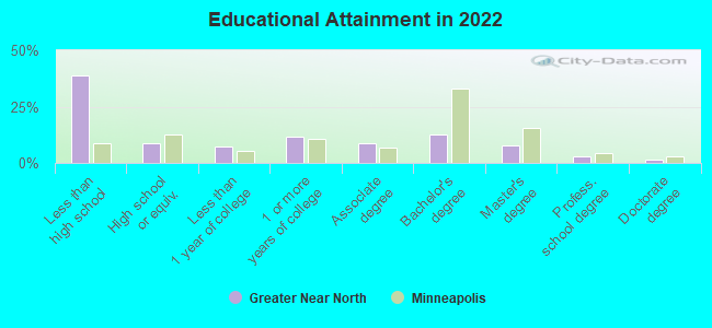
Education in this neighborhood (subdivision or community):
- Percentage of people 3 years and older in K-12 schools:
Greater Near North: 32.1% Minneapolis: 14.0%
- Percentage of people 3 years and older in undergraduate colleges:
Greater Near North: 5.9% Minneapolis: 8.6%
- Percentage of people 3 years and older in grad. or professional schools:
Greater Near North: 2.2% Minneapolis: 2.9%
- Percentage of students K-12 enrolled in private schools:
Greater Near North: 47.7% Minneapolis: 14.1%
Percentage of population below poverty level:
| Greater Near North: | 31.7% |
| Minneapolis: | 17.2% |
Percentage of married-couple families with both working:
| Greater Near North: | 94.7% |
| Minneapolis: | 73.9% |
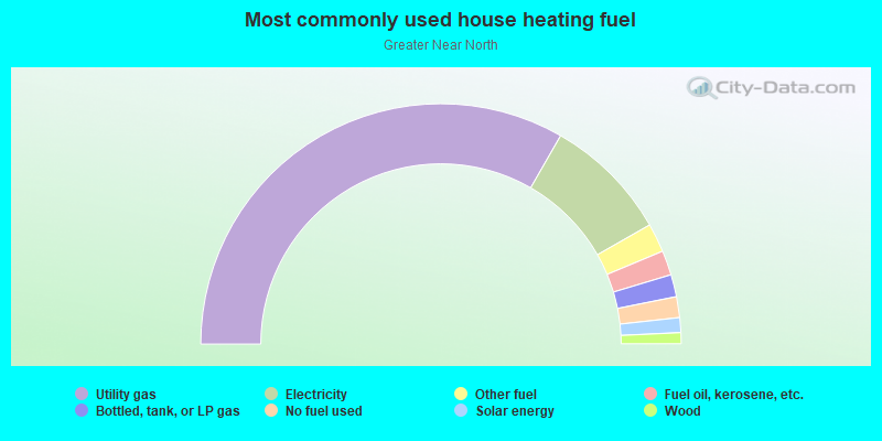
- 66.6%Utility gas
- 16.9%Electricity
- 3.9%Other fuel
- 3.3%Fuel oil, kerosene, etc.
- 3.0%Bottled, tank, or LP gas
- 2.8%No fuel used
- 2.0%Solar energy
- 1.5%Wood
Limited-access highways (interstate or state) in this neighborhood:
I- 94 (US Hwy 52)
Length: 1.72 miles
Directions: N-S, SW-NE
Directions: N-S, SW-NE
Highways in this neighborhood:
Olson Memorial Hwy (State Hwy 55)
Length: 3.83 miles
Direction: E-W
Address range: 689 to 2199
Direction: E-W
Address range: 689 to 2199
Roads and streets:
Co Rd 81 (W Broadway Ave)
Length: 3.17 miles
Directions: E-W, N-S, SE-NW
Address range: 1 to 2899
Directions: E-W, N-S, SE-NW
Address range: 1 to 2899
Plymouth Ave N
Length: 2.89 miles
Directions: E-W, SW-NE
Address range: 50 to 2899
Directions: E-W, SW-NE
Address range: 50 to 2899
26th Ave N
Length: 2.85 miles
Direction: E-W
Address range: 1 to 2899
Direction: E-W
Address range: 1 to 2899
30th Ave N
Length: 2.70 miles
Direction: E-W
Address range: 1 to 2899
Direction: E-W
Address range: 1 to 2899
27th Ave N
Length: 2.70 miles
Directions: E-W, N-S, SW-NE
Address range: 1 to 2799
Directions: E-W, N-S, SW-NE
Address range: 1 to 2799
29th Ave N
Length: 2.50 miles
Direction: E-W
Address range: 200 to 2899
Direction: E-W
Address range: 200 to 2899
Lyndale Ave N
Length: 2.47 miles
Directions: N-S, SW-NE
Address range: 169 to 3199
Directions: N-S, SW-NE
Address range: 169 to 3199
16th Ave N
Length: 2.30 miles
Direction: E-W
Address range: 100 to 2819
Direction: E-W
Address range: 100 to 2819
14th Ave N
Length: 2.28 miles
Direction: E-W
Address range: 100 to 2924
Direction: E-W
Address range: 100 to 2924
James Ave N
Length: 2.28 miles
Directions: E-W, N-S, SE-NW, SW-NE
Address range: 100 to 2999
Directions: E-W, N-S, SE-NW, SW-NE
Address range: 100 to 2999
Co Rd 2 (Penn Ave N)
Length: 2.27 miles
Directions: N-S, SW-NE
Address range: 201 to 2999
Directions: N-S, SW-NE
Address range: 201 to 2999
23rd Ave N
Length: 2.22 miles
Directions: E-W, N-S, SE-NW
Address range: 300 to 2799
Directions: E-W, N-S, SE-NW
Address range: 300 to 2799
Irving Ave N
Length: 2.17 miles
Directions: N-S, SE-NW, SW-NE
Address range: 200 to 2999
Directions: N-S, SE-NW, SW-NE
Address range: 200 to 2999
21st Ave N
Length: 2.15 miles
Directions: E-W, SE-NW
Address range: 100 to 2899
Directions: E-W, SE-NW
Address range: 100 to 2899
Morgan Ave N
Length: 2.08 miles
Directions: N-S, SE-NW
Address range: 100 to 2999
Directions: N-S, SE-NW
Address range: 100 to 2999
Queen Ave N
Length: 2.04 miles
Directions: E-W, N-S, SE-NW
Address range: 200 to 2999
Directions: E-W, N-S, SE-NW
Address range: 200 to 2999
Logan Ave N
Length: 2.02 miles
Directions: N-S, SE-NW, SW-NE
Address range: 100 to 2999
Directions: N-S, SE-NW, SW-NE
Address range: 100 to 2999
Sheridan Ave N
Length: 1.96 miles
Directions: E-W, N-S, SE-NW, SW-NE
Address range: 500 to 2999
Directions: E-W, N-S, SE-NW, SW-NE
Address range: 500 to 2999
Dupont Ave N
Length: 1.94 miles
Directions: E-W, N-S, SE-NW, SW-NE
Address range: 268 to 3099
Directions: E-W, N-S, SE-NW, SW-NE
Address range: 268 to 3099
Thomas Ave N
Length: 1.93 miles
Directions: N-S, SE-NW
Address range: 500 to 2999
Directions: N-S, SE-NW
Address range: 500 to 2999
Bryant Ave N
Length: 1.92 miles
Directions: E-W, N-S, SE-NW, SW-NE
Address range: 200 to 2999
Directions: E-W, N-S, SE-NW, SW-NE
Address range: 200 to 2999
17th Ave N
Length: 1.88 miles
Direction: E-W
Address range: 1 to 2899
Direction: E-W
Address range: 1 to 2899
24th Ave N
Length: 1.87 miles
Direction: E-W
Address range: 100 to 2799
Direction: E-W
Address range: 100 to 2799
Newton Ave N
Length: 1.87 miles
Directions: E-W, N-S, SE-NW, SW-NE
Address range: 300 to 2999
Directions: E-W, N-S, SE-NW, SW-NE
Address range: 300 to 2999
Upton Ave N
Length: 1.83 miles
Direction: N-S
Address range: 620 to 2999
Direction: N-S
Address range: 620 to 2999
Vincent Ave N
Length: 1.83 miles
Direction: N-S
Address range: 629 to 2999
Direction: N-S
Address range: 629 to 2999
Oliver Ave N
Length: 1.82 miles
Directions: E-W, N-S, SW-NE
Address range: 200 to 2952
Directions: E-W, N-S, SW-NE
Address range: 200 to 2952
Russell Ave N
Length: 1.81 miles
Directions: N-S, SW-NE
Address range: 300 to 2999
Directions: N-S, SW-NE
Address range: 300 to 2999
25th Ave N
Length: 1.81 miles
Directions: E-W, SE-NW, SW-NE
Address range: 300 to 2199
Directions: E-W, SE-NW, SW-NE
Address range: 300 to 2199
Aldrich Ave N
Length: 1.80 miles
Direction: N-S
Address range: 100 to 2999
Direction: N-S
Address range: 100 to 2999
22nd Ave N
Length: 1.78 miles
Directions: E-W, SE-NW, SW-NE
Address range: 1 to 1699
Directions: E-W, SE-NW, SW-NE
Address range: 1 to 1699
Glenwood Ave
Length: 1.71 miles
Direction: E-W
Address range: 700 to 2599
Direction: E-W
Address range: 700 to 2599
8th Ave N
Length: 1.71 miles
Directions: E-W, SE-NW
Address range: 692 to 2899
Directions: E-W, SE-NW
Address range: 692 to 2899
Fremont Ave N
Length: 1.68 miles
Directions: N-S, SE-NW, SW-NE
Address range: 200 to 2999
Directions: N-S, SE-NW, SW-NE
Address range: 200 to 2999
12th Ave N
Length: 1.50 miles
Directions: E-W, SE-NW
Address range: 800 to 2899
Directions: E-W, SE-NW
Address range: 800 to 2899
2nd Ave N
Length: 1.50 miles
Directions: E-W, SE-NW
Address range: 700 to 2399
Directions: E-W, SE-NW
Address range: 700 to 2399
N Emerson Ave
Length: 1.49 miles
Directions: N-S, SE-NW
Address range: 631 to 2599
Directions: N-S, SE-NW
Address range: 631 to 2599
Girard Ave N
Length: 1.47 miles
Directions: N-S, SW-NE
Address range: 100 to 2999
Directions: N-S, SW-NE
Address range: 100 to 2999
Humboldt Ave N
Length: 1.39 miles
Directions: N-S, SE-NW
Address range: 1 to 2999
Directions: N-S, SE-NW
Address range: 1 to 2999
Washington Ave N
Length: 1.38 miles
Directions: N-S, SE-NW
Address range: 1300 to 3099
Directions: N-S, SE-NW
Address range: 1300 to 3099
N 2nd St
Length: 1.38 miles
Directions: N-S, SE-NW
Address range: 1300 to 3099
Directions: N-S, SE-NW
Address range: 1300 to 3099
Golden Valley Rd
Length: 1.37 miles
Direction: E-W
Address range: 1300 to 2899
Direction: E-W
Address range: 1300 to 2899
18th Ave N
Length: 1.31 miles
Directions: E-W, SE-NW
Address range: 200 to 2099
Directions: E-W, SE-NW
Address range: 200 to 2099
15th Ave N
Length: 1.23 miles
Direction: E-W
Address range: 200 to 2199
Direction: E-W
Address range: 200 to 2199
Oak Park Ave N
Length: 1.22 miles
Directions: E-W, SE-NW, SW-NE
Address range: 1500 to 2899
Directions: E-W, SE-NW, SW-NE
Address range: 1500 to 2899
5th Ave N
Length: 1.20 miles
Directions: E-W, SE-NW
Address range: 800 to 2499
Directions: E-W, SE-NW
Address range: 800 to 2499
4th Ave N
Length: 1.16 miles
Direction: E-W
Address range: 800 to 2399
Direction: E-W
Address range: 800 to 2399
Knox Ave N
Length: 1.11 miles
Directions: N-S, SW-NE
Address range: 300 to 2999
Directions: N-S, SW-NE
Address range: 300 to 2999
31st Ave N
Length: 1.09 miles
Direction: E-W
Address range: 1 to 1099
Direction: E-W
Address range: 1 to 1099
Washburn Ave N
Length: 1.07 miles
Directions: N-S, SE-NW, SW-NE
Address range: 800 to 2999
Directions: N-S, SE-NW, SW-NE
Address range: 800 to 2999
N 4th St
Length: 0.96 miles
Directions: N-S, SE-NW, SW-NE
Address range: 1800 to 3099
Directions: N-S, SE-NW, SW-NE
Address range: 1800 to 3099
N 3rd St
Length: 0.89 miles
Directions: E-W, N-S, SE-NW, SW-NE
Address range: 2000 to 3099
Directions: E-W, N-S, SE-NW, SW-NE
Address range: 2000 to 3099
W River Rd N
Length: 0.79 miles
Directions: N-S, SE-NW, SW-NE
Address range: 1301 to 2399
Directions: N-S, SE-NW, SW-NE
Address range: 1301 to 2399
McNair Ave N
Length: 0.72 miles
Directions: E-W, SW-NE
Address range: 2200 to 2999
Directions: E-W, SW-NE
Address range: 2200 to 2999
6th St N
Length: 0.72 miles
Direction: N-S
Address range: 2000 to 3199
Direction: N-S
Address range: 2000 to 3199
Elwood Ave N
Length: 0.70 miles
Directions: E-W, N-S, SE-NW
Address range: 617 to 899
Directions: E-W, N-S, SE-NW
Address range: 617 to 899
11th Ave N
Length: 0.64 miles
Direction: E-W
Address range: 800 to 1699
Direction: E-W
Address range: 800 to 1699
28th Ave N
Length: 0.61 miles
Direction: E-W
Address range: 1 to 399
Direction: E-W
Address range: 1 to 399
Colfax Ave N
Length: 0.58 miles
Direction: N-S
Address range: 200 to 3099
Direction: N-S
Address range: 200 to 3099
N 7th St
Length: 0.56 miles
Directions: E-W, N-S, SE-NW
Address range: 1000 to 1299
Directions: E-W, N-S, SE-NW
Address range: 1000 to 1299
Hillside Ave N
Length: 0.55 miles
Directions: E-W, SE-NW
Address range: 1500 to 2099
Directions: E-W, SE-NW
Address range: 1500 to 2099
3rd Ave N
Length: 0.52 miles
Directions: E-W, SE-NW
Address range: 800 to 2199
Directions: E-W, SE-NW
Address range: 800 to 2199
N Theodore Wirth Pkwy
Length: 0.52 miles
Directions: N-S, SE-NW, SW-NE
Directions: N-S, SE-NW, SW-NE
Ilion Ave N
Length: 0.47 miles
Directions: E-W, N-S, SW-NE
Address range: 2000 to 2499
Directions: E-W, N-S, SW-NE
Address range: 2000 to 2499
N Cedar Lake Rd
Length: 0.42 miles
Direction: SW-NE
Address range: 64 to 319
Direction: SW-NE
Address range: 64 to 319
N Pacific St
Length: 0.42 miles
Direction: N-S
Address range: 2600 to 3099
Direction: N-S
Address range: 2600 to 3099
Emerson Ave N
Length: 0.37 miles
Direction: N-S
Address range: 2652 to 2999
Direction: N-S
Address range: 2652 to 2999
Farwell Ave
Length: 0.35 miles
Directions: E-W, SE-NW
Address range: 2500 to 2899
Directions: E-W, SE-NW
Address range: 2500 to 2899
Currie Ave W
Length: 0.33 miles
Direction: E-W
Address range: 800 to 1599
Direction: E-W
Address range: 800 to 1599
Girard Ter
Length: 0.33 miles
Directions: E-W, N-S, SW-NE
Address range: 401 to 599
Directions: E-W, N-S, SW-NE
Address range: 401 to 599
7th Ave N
Length: 0.30 miles
Direction: E-W
Address range: 692 to 1399
Direction: E-W
Address range: 692 to 1399
1st 1/2 Ave N
Length: 0.26 miles
Direction: E-W
Address range: 1900 to 2199
Direction: E-W
Address range: 1900 to 2199
N Willow Ave
Length: 0.25 miles
Direction: SE-NW
Address range: 1900 to 2199
Direction: SE-NW
Address range: 1900 to 2199
Service Rd
Length: 0.21 miles
Directions: E-W, N-S, SE-NW
Address range: 901 to 999
Directions: E-W, N-S, SE-NW
Address range: 901 to 999
Inglewood Ave N
Length: 0.21 miles
Direction: E-W
Address range: 2300 to 2599
Direction: E-W
Address range: 2300 to 2599
Ferrant Pl
Length: 0.21 miles
Directions: E-W, SE-NW
Address range: 2300 to 2499
Directions: E-W, SE-NW
Address range: 2300 to 2499
Lowry Ave N (Co Rd 153)
Length: 0.20 miles
Direction: E-W
Address range: 600 to 798
Direction: E-W
Address range: 600 to 798
Gramercy Ave
Length: 0.18 miles
Directions: N-S, SW-NE
Address range: 200 to 399
Directions: N-S, SW-NE
Address range: 200 to 399
Hall Ln
Length: 0.17 miles
Directions: E-W, N-S, SW-NE
Address range: 500 to 699
Directions: E-W, N-S, SW-NE
Address range: 500 to 699
18th 1/2 Ave N
Length: 0.16 miles
Direction: E-W
Direction: E-W
Thomas Pl N
Length: 0.15 miles
Directions: E-W, SW-NE
Address range: 1600 to 1799
Directions: E-W, SW-NE
Address range: 1600 to 1799
3rd St N
Length: 0.15 miles
Direction: N-S
Address range: 1300 to 1499
Direction: N-S
Address range: 1300 to 1499
Boardwalk Ave
Length: 0.14 miles
Directions: E-W, N-S
Address range: 1300 to 1399
Directions: E-W, N-S
Address range: 1300 to 1399
Barnes Pl
Length: 0.13 miles
Direction: E-W
Address range: 1400 to 1499
Direction: E-W
Address range: 1400 to 1499
Hall Curve
Length: 0.13 miles
Directions: E-W, N-S, SW-NE
Address range: 1400 to 1599
Directions: E-W, N-S, SW-NE
Address range: 1400 to 1599
Ojibway St N
Length: 0.12 miles
Directions: E-W, N-S
Address range: 1300 to 1399
Directions: E-W, N-S
Address range: 1300 to 1399
Lyn-Park Ave N
Length: 0.12 miles
Directions: N-S, SE-NW, SW-NE
Address range: 1600 to 1799
Directions: N-S, SE-NW, SW-NE
Address range: 1600 to 1799
Harry Davis Ln
Length: 0.12 miles
Directions: E-W, N-S, SE-NW, SW-NE
Address range: 600 to 699
Directions: E-W, N-S, SE-NW, SW-NE
Address range: 600 to 699
13th Ave N
Length: 0.12 miles
Direction: E-W
Address range: 1300 to 1499
Direction: E-W
Address range: 1300 to 1499
19th Ave N
Length: 0.11 miles
Direction: E-W
Address range: 200 to 299
Direction: E-W
Address range: 200 to 299
Dakota Cir
Length: 0.11 miles
Direction: E-W
Address range: 1248 to 1399
Direction: E-W
Address range: 1248 to 1399
Banneker Ave N
Length: 0.10 miles
Direction: E-W
Address range: 1200 to 1299
Direction: E-W
Address range: 1200 to 1299
Olson Hwy Svc Rd
Length: 0.10 miles
Directions: E-W, SE-NW
Address range: 2600 to 2699
Directions: E-W, SE-NW
Address range: 2600 to 2699
Lyn-Curve Ave N
Length: 0.10 miles
Directions: N-S, SE-NW, SW-NE
Address range: 1600 to 1799
Directions: N-S, SE-NW, SW-NE
Address range: 1600 to 1799
Farwell Pl
Length: 0.09 miles
Direction: E-W
Address range: 2500 to 2599
Direction: E-W
Address range: 2500 to 2599
Heaner Ter N
Length: 0.09 miles
Direction: E-W
Address range: 2500 to 2599
Direction: E-W
Address range: 2500 to 2599
Chestnut Ave W
Length: 0.09 miles
Direction: E-W
Address range: 1800 to 1899
Direction: E-W
Address range: 1800 to 1899
12th 1/2 Ave N
Length: 0.09 miles
Direction: E-W
Address range: 2000 to 2099
Direction: E-W
Address range: 2000 to 2099
Olson Highway Svc Rd (6th Ave N)
Length: 0.09 miles
Direction: E-W
Address range: 801 to 899
Direction: E-W
Address range: 801 to 899
Walton Pl
Length: 0.09 miles
Direction: SW-NE
Address range: 2300 to 2399
Direction: SW-NE
Address range: 2300 to 2399
N 6th St S
Length: 0.08 miles
Direction: N-S
Address range: 1300 to 1599
Direction: N-S
Address range: 1300 to 1599
Skyline Curve Ave
Length: 0.08 miles
Direction: N-S
Address range: 1800 to 1999
Direction: N-S
Address range: 1800 to 1999
Lyn-Park Cir N
Length: 0.07 miles
Directions: E-W, SW-NE
Address range: 500 to 599
Directions: E-W, SW-NE
Address range: 500 to 599
Lyn-Park Ln N
Length: 0.07 miles
Directions: E-W, N-S, SW-NE
Address range: 500 to 599
Directions: E-W, N-S, SW-NE
Address range: 500 to 599
Market St
Length: 0.07 miles
Direction: N-S
Address range: 200 to 299
Direction: N-S
Address range: 200 to 299
Boardwalk Pl
Length: 0.07 miles
Directions: E-W, N-S, SW-NE
Address range: 1300 to 1399
Directions: E-W, N-S, SW-NE
Address range: 1300 to 1399
5th St N
Length: 0.07 miles
Direction: N-S
Address range: 1844 to 1899
Direction: N-S
Address range: 1844 to 1899
Smith Cir
Length: 0.06 miles
Direction: E-W
Address range: 1101 to 1151
Direction: E-W
Address range: 1101 to 1151
Howell Dr N
Length: 0.06 miles
Direction: E-W
Address range: 1100 to 1199
Direction: E-W
Address range: 1100 to 1199
New York Ave N
Length: 0.06 miles
Direction: N-S
Address range: 1800 to 1843
Direction: N-S
Address range: 1800 to 1843
Givens Ln
Length: 0.05 miles
Direction: E-W
Address range: 700 to 799
Direction: E-W
Address range: 700 to 799
Elizabeth Ln
Length: 0.05 miles
Direction: E-W
Address range: 700 to 799
Direction: E-W
Address range: 700 to 799
Printice Ln (Prentice Ln)
Length: 0.05 miles
Direction: E-W
Address range: 700 to 799
Direction: E-W
Address range: 700 to 799
N Knox Ave N
Length: 0.05 miles
Direction: N-S
Address range: 1900 to 1999
Direction: N-S
Address range: 1900 to 1999
Lyndale Pl
Length: 0.05 miles
Direction: N-S
Direction: N-S
State Hwy 55 Svc Rd
Length: 0.04 miles
Direction: SE-NW
Direction: SE-NW
Rawlins Cir N
Length: 0.04 miles
Direction: N-S
Address range: 900 to 999
Direction: N-S
Address range: 900 to 999
Mill St
Length: 0.03 miles
Direction: E-W
Address range: 2600 to 2699
Direction: E-W
Address range: 2600 to 2699
Plymouth Ave NE
Length: 0.03 miles
Direction: E-W
Direction: E-W
Van White Ln
Length: 0.02 miles
Direction: N-S
Address range: 1400 to 1499
Direction: N-S
Address range: 1400 to 1499
Railroad features:
Burlington Northern Santa Fe Rlwy
Length: 1.84 miles
Directions: E-W, N-S, SE-NW, SW-NE
Directions: E-W, N-S, SE-NW, SW-NE
Canadian Pacific Rlwy
Length: 0.81 miles
Directions: N-S, SE-NW
Directions: N-S, SE-NW
Burlington Northern Santa Fe Rlwy (Union Pacific RR)
Length: 0.31 miles
Direction: SE-NW
Direction: SE-NW
Other features:
Bassett Crk
Length: 1.04 miles
Directions: E-W, N-S, SW-NE
Directions: E-W, N-S, SW-NE