Hunt's Point neighborhood in Bronx, New York (NY), 10459, 10474 detailed profile
Settings
X


Business Search - 14 Million verified businesses
Area: 1.650 square miles
Population: 135,559
Population density:
| Hunt's Point: | 82,150 people per square mile |
| Bronx: | 31,709 people per square mile |

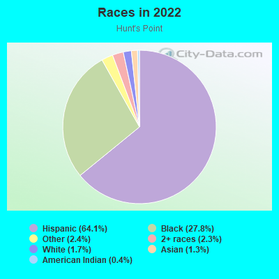
- 90,92464.1%Hispanic or Latino
- 39,39727.8%Black
- 3,4182.4%Some other race
- 3,3172.3%Two or more races
- 2,4791.7%White
- 1,8261.3%Asian
- 5040.4%American Indian
Distribution of median household income
![Distribution of median household income]()
- 5,948Less than $10,000
- 12,056$10,000 to $19,999
- 7,005$20,000 to $29,999
- 7,046$30,000 to $39,999
- 3,833$40,000 to $49,999
- 4,847$50,000 to $59,999
- 4,738$60,000 to $74,999
- 5,416$75,000 to $99,999
- 1,713$100,000 to $124,999
- 4,529$125,000 to $149,999
- 4,010$150,000 to $199,999
- 2,000$200,000 or more

Distribution of owner-occupied house/condo value
![Distribution of owner-occupied house/condo value]()
- 5,093Less than $50,000
- 8,556$50,000 to $99,999
- 4,835$100,000 to $149,999
- 1,371$200,000 to $249,999
- 1,226$300,000 to $399,999
- 3,649$400,000 to $499,999
- 3,670$500,000 to $749,999
- 1,809$750,000 to $999,999
- 1,084$1,000,000 or more

Distribution of rent paid by renters
![Distribution of rent paid by renters]()
- 2,210Less than $100
- 4,401$100 to $199
- 5,732$200 to $299
- 7,488$300 to $399
- 5,176$400 to $499
- 8,086$500 to $599
- 4,324$600 to $699
- 7,621$700 to $799
- 3,559$800 to $899
- 2,843$900 to $999
- 5,271$1,000 to $1,249
- 8,013$1,250 to $1,499
- 6,766$1,500 to $1,999
- 10,989$2,000 or more

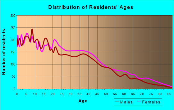
| Males: | 64,689 |
| Females: | 70,870 |
| Males: | 27.0 years |
| Females: | 35.0 years |
Average household size:
| Hunt's Point: | 2.7 people |
| New York: | 2.5 people |
Percentage of family households:
| Hunt's Point: | 53.4% |
| New York: | 41.3% |
| Here: | 17.6% |
| New York: | 42.3% |
Percentage of married-couple families with children (among all households):
| Hunt's Point: | 10.7% |
| New York: | 57.0% |
Percentage of single-mother households (among all households):
| Hunt's Point: | 18.5% |
| New York: | 9.3% |
Percentage of never married males 15 years old and over:
Percentage of never married females 15 years old and over:
| Hunt's Point: | 27.2% |
| New York: | 19.8% |
Percentage of never married females 15 years old and over:
| Hunt's Point: | 29.9% |
| New York: | 18.9% |
Percentage of people that speak English not well or not at all:
| Hunt's Point: | 15.2% |
| New York: | 6.8% |
Percentage of people born in this state:
Percentage of people born in another U.S. state:
Percentage of native residents but born outside the U.S.:
Percentage of foreign born residents:
| Here: | 58.6% |
| New York: | 62.5% |
Percentage of people born in another U.S. state:
| Hunt's Point: | 9.2% |
| New York: | 12.2% |
Percentage of native residents but born outside the U.S.:
| Here: | 9.3% |
| New York: | 2.6% |
Percentage of foreign born residents:
| Here: | 22.9% |
| New York: | 22.7% |
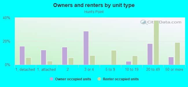
Owner-occupied
Renter-occupied

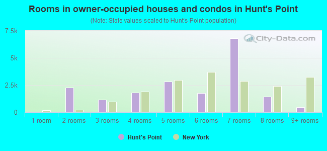
- Rooms in owner-occupied houses and condos in Hunt's Point
- 01 room
- 2,2832 rooms
- 1,1423 rooms
- 1,8214 rooms
- 2,8085 rooms
- 1,7436 rooms
- 6,7967 rooms
- 1,4188 rooms
- 4619+ rooms
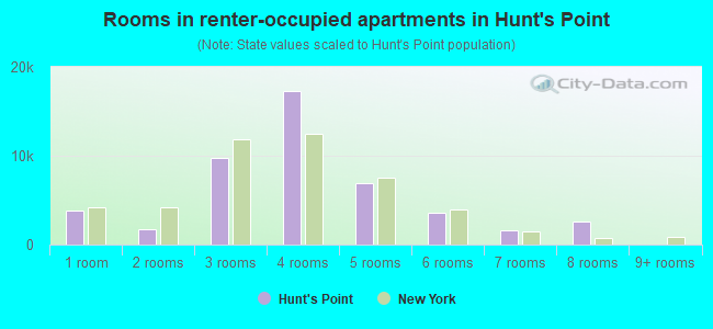
- Rooms in renter-occupied apartments in Hunt's Point
- 3,8321 room
- 1,7622 rooms
- 9,7753 rooms
- 17,2564 rooms
- 6,9035 rooms
- 3,5216 rooms
- 1,5707 rooms
- 2,5978 rooms
- 09+ rooms
Owner-occupied
Renter-occupied
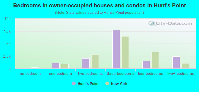
- Bedrooms in owner-occupied houses and condos in Hunt's Point
- 0no bedroom
- 1,0941 bedroom
- 2,0262 bedrooms
- 7,7163 bedrooms
- 1,4844 bedrooms
- 2,4295+ bedrooms
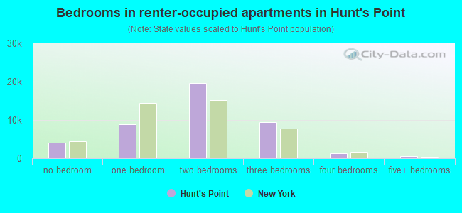
- Bedrooms in renter-occupied apartments in Hunt's Point
- 4,032no bedroom
- 8,9601 bedroom
- 19,5552 bedrooms
- 9,4013 bedrooms
- 1,3124 bedrooms
- 5475+ bedrooms
Average number of cars or other vehicles available in houses/condos:
Average number of cars or other vehicles available in apartments:
| This neighborhood: | |
| New York: |
Average number of cars or other vehicles available in apartments:
| Here: | 0.3 |
| New York: | 0.7 |
Percentage of units with a mortgage:
| Hunt's Point: | 53.1% |
| New York: | 58.3% |
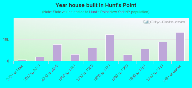
- Year house built in Hunt's Point
- 6462020 or later
- 2,0572010 to 2019
- 7,6842000 to 2009
- 3,0691990 to 1999
- 6,0331980 to 1989
- 12,2411970 to 1979
- 2,9041960 to 1969
- 5,5771950 to 1959
- 8,9311940 to 1949
- 13,1651939 or earlier
Travel time to work (commute)
![Travel time to work (commute)]()
- 494Less than 5 minutes
- 1,8925 to 9 minutes
- 2,49210 to 14 minutes
- 3,88515 to 19 minutes
- 3,27920 to 24 minutes
- 42125 to 29 minutes
- 5,05830 to 34 minutes
- 2,20335 to 39 minutes
- 4,15140 to 44 minutes
- 6,08145 to 59 minutes
- 10,96160 to 89 minutes
- 5,60990 or more minutes

Means of transportation to work
![Means of transportation to work]()
- 16.4%8,178Drove a car alone
- 4.6%2,277Carpooled
- 16.3%8,087Bus
- 47.0%23,383Subway or elevated rail
- 6.9%3,433Long-distance train or commuter rail
- 4.7%2,350Taxi
- 8.8%4,372Bicycle
- 10.3%5,128Walked
- 4.9%2,429Other means
- 9.0%4,461Worked at home

Time leaving home to go to work
![Time leaving home to go to work]()
- 3,01412:00 a.m. to 4:59 a.m.
- 2,3935:00 a.m. to 5:29 a.m.
- 1,7105:30 a.m. to 5:59 a.m.
- 2,8816:00 a.m. to 6:29 a.m.
- 4,3016:30 a.m. to 6:59 a.m.
- 3,4417:00 a.m. to 7:29 a.m.
- 5,2367:30 a.m. to 7:59 a.m.
- 4,6478:00 a.m. to 8:29 a.m.
- 1,3338:30 a.m. to 8:59 a.m.
- 2,4809:00 a.m. to 9:59 a.m.
- 3,17810:00 a.m. to 10:59 a.m.
- 47911:00 a.m. to 11:59 a.m.
- 3,92012:00 p.m. to 3:59 p.m.
- 4,9824:00 p.m. to 11:59 p.m.

Occupations of males:
- Percentage of males in management occupations (except farmers):
Here: 6.9% New York: 11.9%
- Percentage of males in life, physical, and social science occupations:
Here: 5.0% New York: 1.0%
- Percentage of males in community and social services occupations:
Here: 1.8% New York: 1.3%
- Percentage of males in healthcare practitioners and technical occupations:
Here: 2.3% New York: 3.6%
- Percentage of males in service occupations:
Here: 36.4% New York: 16.9%
- Percentage of males in sales and office occupations:
Here: 16.5% New York: 15.2%
- Percentage of males in construction, extraction, and maintenance occupations:
Here: 6.2% New York: 8.2%
- Percentage of males in production occupations:
Here: 5.1% New York: 4.6%
- Percentage of males in transportation occupations:
Here: 8.8% New York: 6.7%
- Percentage of males in material moving occupations:
Here: 7.1% New York: 3.7%
Occupations of females:
- Percentage of females in management occupations (except farmers):
Here: 4.8% New York: 9.8%
- Percentage of females in community and social services occupations:
Here: 2.4% New York: 3.1%
- Percentage of females in education, training, and library occupations:
Here: 7.5% New York: 11.3%
- Percentage of females in healthcare practitioners and technical occupations:
Here: 3.5% New York: 9.7%
- Percentage of females in service occupations:
Here: 51.8% New York: 21.4%
- Percentage of females in sales and office occupations:
Here: 22.5% New York: 24.9%
- Percentage of females in production occupations:
Here: 1.8% New York: 2.0%
- Percentage of females in transportation occupations:
Here: 3.7% New York: 1.0%
Percentage of people 16-64 in Armed Forces:
| Hunt's Point: | 0.5% |
| New York: | 0.2% |
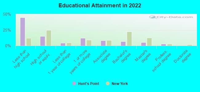
Education in this neighborhood (subdivision or community):
- Percentage of people 3 years and older in K-12 schools:
Hunt's Point: 38.4% New York: 15.4%
- Percentage of people 3 years and older in undergraduate colleges:
Hunt's Point: 11.1% New York: 5.3%
- Percentage of people 3 years and older in grad. or professional schools:
Hunt's Point: 2.0% New York: 1.8%
- Percentage of students K-12 enrolled in private schools:
Hunt's Point: 48.5% New York: 15.5%
Percentage of population below poverty level:
| Hunt's Point: | 33.2% |
| New York: | 14.3% |
Median year renter moved in (as recorded in 2022):
| Hunt's Point: | 2010 |
| New York: | 2018 |
Percentage of married-couple families with both working:
| Hunt's Point: | 272.8% |
| New York: | 72.1% |
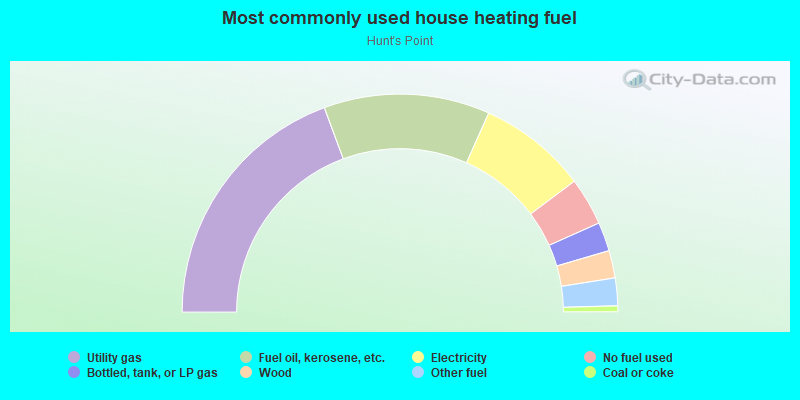
- 38.8%Utility gas
- 24.7%Fuel oil, kerosene, etc.
- 16.2%Electricity
- 7.1%No fuel used
- 4.3%Bottled, tank, or LP gas
- 4.1%Wood
- 4.1%Other fuel
- 0.9%Coal or coke
Limited-access highways (interstate or state) in this neighborhood:
I- 278 (Bruckner Expy)
Length: 0.41 miles
Directions: E-W, SW-NE
Directions: E-W, SW-NE
Roads and streets:
Hunts Point Ave
Length: 1.83 miles
Directions: E-W, SE-NW
Address range: 400 to 920
Directions: E-W, SE-NW
Address range: 400 to 920
Bryant Ave
Length: 1.50 miles
Directions: N-S, SE-NW
Address range: 200 to 1099
Directions: N-S, SE-NW
Address range: 200 to 1099
Longfellow Ave
Length: 1.41 miles
Directions: N-S, SE-NW, SW-NE
Address range: 300 to 1118
Directions: N-S, SE-NW, SW-NE
Address range: 300 to 1118
Faile St
Length: 1.34 miles
Directions: N-S, SE-NW
Address range: 300 to 1098
Directions: N-S, SE-NW
Address range: 300 to 1098
Bruckner Blvd
Length: 1.14 miles
Directions: E-W, SW-NE
Address range: 1021 to 1399
Directions: E-W, SW-NE
Address range: 1021 to 1399
Food Center Dr
Length: 1.13 miles
Directions: E-W, SE-NW, SW-NE
Address range: 1 to 861
Directions: E-W, SE-NW, SW-NE
Address range: 1 to 861
Garrison Ave
Length: 1.13 miles
Directions: E-W, SW-NE
Address range: 700 to 1379
Directions: E-W, SW-NE
Address range: 700 to 1379
Whittier St
Length: 1.11 miles
Directions: N-S, SE-NW
Address range: 200 to 979
Directions: N-S, SE-NW
Address range: 200 to 979
Manida St
Length: 1.03 miles
Directions: N-S, SE-NW
Address range: 200 to 899
Directions: N-S, SE-NW
Address range: 200 to 899
Oak Point Ave (Oakpoint Ave)
Length: 0.99 miles
Direction: E-W
Address range: 1100 to 1399
Direction: E-W
Address range: 1100 to 1399
Barretto St
Length: 0.95 miles
Directions: N-S, SE-NW
Address range: 300 to 899
Directions: N-S, SE-NW
Address range: 300 to 899
Lafayette Ave
Length: 0.87 miles
Directions: E-W, SW-NE
Address range: 1100 to 1415
Directions: E-W, SW-NE
Address range: 1100 to 1415
Tiffany St
Length: 0.87 miles
Directions: N-S, SE-NW, SW-NE
Address range: 200 to 849
Directions: N-S, SE-NW, SW-NE
Address range: 200 to 849
Randall Ave
Length: 0.85 miles
Direction: E-W
Address range: 1140 to 1399
Direction: E-W
Address range: 1140 to 1399
Coster St
Length: 0.84 miles
Direction: N-S
Address range: 200 to 799
Direction: N-S
Address range: 200 to 799
Viele Ave
Length: 0.82 miles
Direction: E-W
Address range: 1200 to 1419
Direction: E-W
Address range: 1200 to 1419
Edgewater Rd
Length: 0.78 miles
Directions: N-S, SE-NW
Address range: 600 to 971
Directions: N-S, SE-NW
Address range: 600 to 971
Drake St
Length: 0.74 miles
Directions: N-S, SW-NE
Address range: 200 to 799
Directions: N-S, SW-NE
Address range: 200 to 799
Spofford Ave
Length: 0.70 miles
Direction: E-W
Address range: 577 to 1399
Direction: E-W
Address range: 577 to 1399
Barry St
Length: 0.67 miles
Directions: N-S, SE-NW, SW-NE
Address range: 491 to 868
Directions: N-S, SE-NW, SW-NE
Address range: 491 to 868
Ryawa Ave
Length: 0.67 miles
Direction: E-W
Address range: 1260 to 1448
Direction: E-W
Address range: 1260 to 1448
E Bay Ave
Length: 0.64 miles
Direction: E-W
Address range: 1200 to 1399
Direction: E-W
Address range: 1200 to 1399
Food Center Rd (Market St, Food Dr, Food Center Dr, Loop Rd)
Length: 0.59 miles
Directions: E-W, N-S
Directions: E-W, N-S
Casanova St
Length: 0.55 miles
Direction: N-S
Address range: 300 to 699
Direction: N-S
Address range: 300 to 699
Halleck St
Length: 0.52 miles
Direction: N-S
Address range: 1 to 601
Direction: N-S
Address range: 1 to 601
Ave A
Length: 0.49 miles
Directions: N-S, SE-NW
Directions: N-S, SE-NW
Hunts Point Co Op Mkt
Length: 0.47 miles
Directions: E-W, N-S, SW-NE
Directions: E-W, N-S, SW-NE
Worthen St
Length: 0.45 miles
Directions: N-S, SE-NW
Address range: 500 to 1199
Directions: N-S, SE-NW
Address range: 500 to 1199
Seneca Ave
Length: 0.44 miles
Direction: E-W
Address range: 1200 to 1379
Direction: E-W
Address range: 1200 to 1379
D Ave (Ave D)
Length: 0.35 miles
Direction: N-S
Direction: N-S
C Ave (Ave C)
Length: 0.35 miles
Direction: N-S
Direction: N-S
Ave B (B Ave)
Length: 0.35 miles
Direction: N-S
Direction: N-S
Truxton St
Length: 0.34 miles
Directions: N-S, SW-NE
Address range: 500 to 799
Directions: N-S, SW-NE
Address range: 500 to 799
Hoe Ave
Length: 0.33 miles
Directions: N-S, SE-NW
Address range: 900 to 1115
Directions: N-S, SE-NW
Address range: 900 to 1115
Thurman Munson Way (E 156th St)
Length: 0.33 miles
Directions: E-W, SE-NW
Address range: 1100 to 1251
Directions: E-W, SE-NW
Address range: 1100 to 1251
Avenue E
Length: 0.33 miles
Direction: N-S
Direction: N-S
E 165th St
Length: 0.32 miles
Direction: E-W
Address range: 1069 to 1175
Direction: E-W
Address range: 1069 to 1175
Leggett Ave
Length: 0.31 miles
Directions: E-W, SE-NW
Address range: 1068 to 1199
Directions: E-W, SE-NW
Address range: 1068 to 1199
1st St
Length: 0.30 miles
Direction: E-W
Direction: E-W
2nd St
Length: 0.30 miles
Direction: E-W
Direction: E-W
Longwood Ave
Length: 0.29 miles
Direction: SE-NW
Address range: 1100 to 1199
Direction: SE-NW
Address range: 1100 to 1199
Ave F
Length: 0.28 miles
Direction: N-S
Direction: N-S
3rd St
Length: 0.27 miles
Direction: E-W
Direction: E-W
Westchester Ave
Length: 0.26 miles
Directions: E-W, SW-NE
Address range: 1100 to 1250
Directions: E-W, SW-NE
Address range: 1100 to 1250
Whitlock Ave
Length: 0.25 miles
Directions: N-S, SW-NE
Address range: 951 to 1089
Directions: N-S, SW-NE
Address range: 951 to 1089
Aldus St
Length: 0.23 miles
Direction: E-W
Address range: 966 to 1049
Direction: E-W
Address range: 966 to 1049
Grinnell Pl
Length: 0.22 miles
Directions: E-W, SE-NW
Address range: 1100 to 1199
Directions: E-W, SE-NW
Address range: 1100 to 1199
Farragut St
Length: 0.18 miles
Direction: N-S
Direction: N-S
Burnet Pl
Length: 0.18 miles
Direction: SE-NW
Address range: 1100 to 1199
Direction: SE-NW
Address range: 1100 to 1199
Dupont St
Length: 0.17 miles
Direction: N-S
Address range: 500 to 599
Direction: N-S
Address range: 500 to 599
Drake Park S
Length: 0.15 miles
Direction: E-W
Address range: 1339 to 1399
Direction: E-W
Address range: 1339 to 1399
Craven St
Length: 0.13 miles
Direction: N-S
Address range: 500 to 599
Direction: N-S
Address range: 500 to 599
One Lighting Pl
Length: 0.13 miles
Direction: N-S
Direction: N-S
Lowell St
Length: 0.10 miles
Direction: E-W
Address range: 1027 to 1063
Direction: E-W
Address range: 1027 to 1063
Irvine St
Length: 0.09 miles
Direction: N-S
Address range: 863 to 909
Direction: N-S
Address range: 863 to 909
Gilbert Pl
Length: 0.09 miles
Direction: E-W
Address range: 1200 to 1229
Direction: E-W
Address range: 1200 to 1229
W Farms Rd
Length: 0.05 miles
Direction: SW-NE
Address range: 1000 to 1099
Direction: SW-NE
Address range: 1000 to 1099
Railroad features:
Hunts Pt Market RR Spur (Hunt's Pt Market RR Spr, Hp Market RR Spur)
Length: 2.39 miles
Directions: E-W, N-S, SE-NW
Directions: E-W, N-S, SE-NW
Amtrak RR
Length: 1.47 miles
Directions: N-S, SW-NE
Directions: N-S, SW-NE
Hunts Pt Market RR Spur
Length: 0.15 miles
Directions: N-S, SE-NW
Directions: N-S, SE-NW
Other features:
Bronx Riv
Length: 0.21 miles
Directions: N-S, SE-NW
Directions: N-S, SE-NW