I-435 (I435) neighborhood in Kansas City, Kansas (KS), 66109, 66111, 66112 detailed profile
Settings
X

Business Search - 14 Million verified businesses
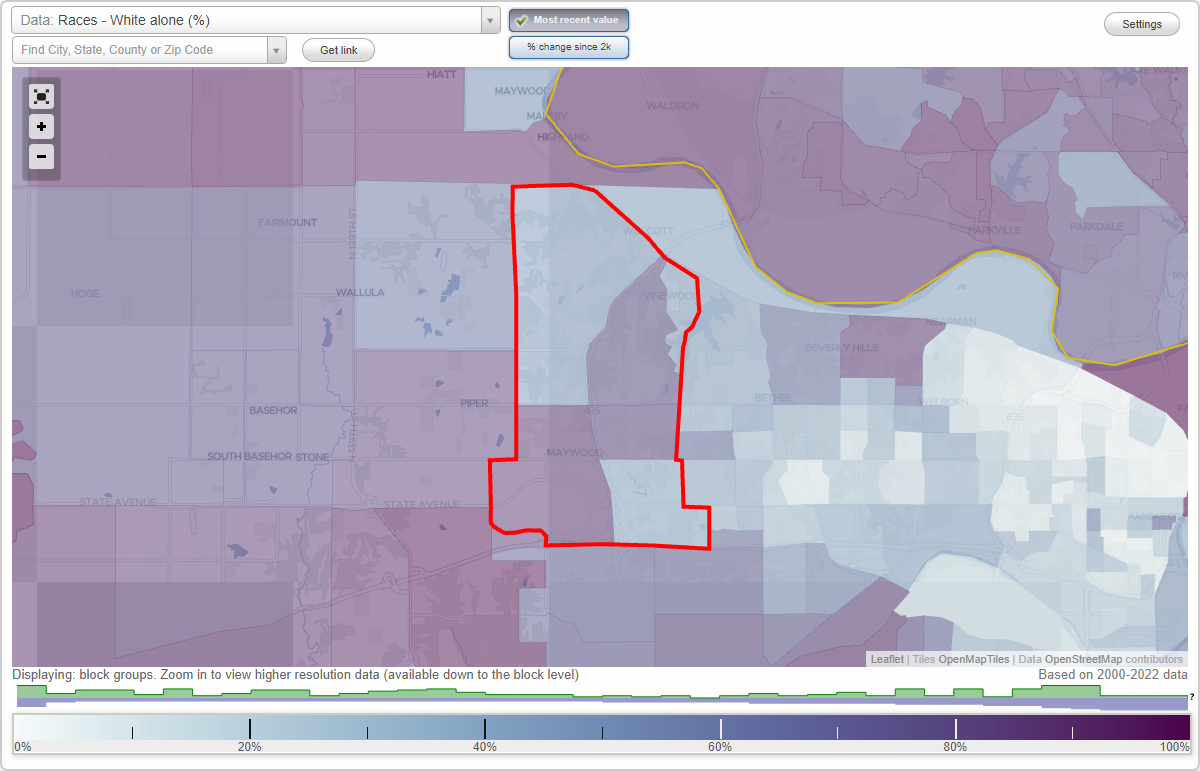
Area: 19.991 square miles
Population: 6,135
Population density:
| I-435 (I435): | 307 people per square mile |
| Kansas City: | 1,228 people per square mile |

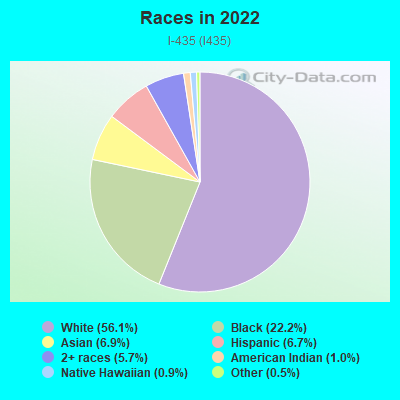
- 3,67256.1%White
- 1,45222.2%Black
- 4546.9%Asian
- 4376.7%Hispanic or Latino
- 3765.7%Two or more races
- 661.0%American Indian
- 560.9%Native Hawaiian and Other
Pacific Islander - 320.5%Some other race
Distribution of median household income
![Distribution of median household income]()
- 67Less than $10,000
- 170$10,000 to $19,999
- 181$20,000 to $29,999
- 339$30,000 to $39,999
- 263$40,000 to $49,999
- 153$50,000 to $59,999
- 210$60,000 to $74,999
- 273$75,000 to $99,999
- 368$100,000 to $124,999
- 205$125,000 to $149,999
- 256$150,000 to $199,999
- 282$200,000 or more

Distribution of owner-occupied house/condo value
![Distribution of owner-occupied house/condo value]()
- 2,111Less than $50,000
- 739$50,000 to $99,999
- 210$100,000 to $149,999
- 363$150,000 to $199,999
- 314$200,000 to $249,999
- 183$250,000 to $299,999
- 459$300,000 to $399,999
- 608$400,000 to $499,999
- 104$500,000 to $749,999
- 15$750,000 to $999,999
- 91$1,000,000 or more

Distribution of rent paid by renters
![Distribution of rent paid by renters]()
- 5$100 to $199
- 110$200 to $299
- 293$400 to $499
- 114$500 to $599
- 168$600 to $699
- 117$700 to $799
- 140$800 to $899
- 168$900 to $999
- 124$1,000 to $1,249
- 120$1,250 to $1,499
- 74$1,500 to $1,999
- 425$2,000 or more

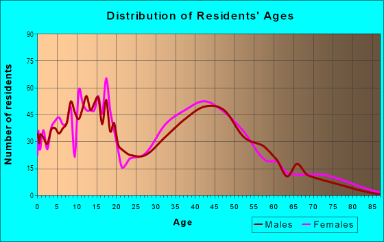
| Males: | 3,273 |
| Females: | 2,861 |
Males:
| This neighborhood: | |
| Whole city: |
| This neighborhood: | |
| Whole city: |
Percentage of family households:
| I-435 (I435): | 56.1% |
| Kansas City: | 46.3% |
| Here: | 61.1% |
| Kansas City: | 36.4% |
Percentage of married-couple families with children (among all households):
| I-435 (I435): | 27.4% |
| Kansas City: | 21.3% |
Percentage of single-mother households (among all households):
| I-435 (I435): | 5.1% |
| Kansas City: | 11.5% |
Percentage of never married males 15 years old and over:
Percentage of never married females 15 years old and over:
| I-435 (I435): | 17.1% |
| Kansas City: | 21.9% |
Percentage of never married females 15 years old and over:
| I-435 (I435): | 13.7% |
| city: | 19.6% |
Percentage of people that speak English not well or not at all:
| I-435 (I435): | 1.2% |
| Kansas City: | 8.4% |
Percentage of people born in this state:
Percentage of people born in another U.S. state:
Percentage of native residents but born outside the U.S.:
Percentage of foreign born residents:
| Here: | 61.8% |
| Kansas City: | 53.9% |
Percentage of people born in another U.S. state:
| I-435 (I435): | 33.4% |
| Kansas City: | 28.8% |
Percentage of native residents but born outside the U.S.:
| Here: | 0.8% |
| city: | 1.1% |
Percentage of foreign born residents:
| Here: | 4.0% |
| Kansas City: | 16.3% |
Owner-occupied
Renter-occupied

- Rooms in owner-occupied houses and condos in I-435 <
> - 1381 room
- 02 rooms
- 1703 rooms
- 1124 rooms
- 1845 rooms
- 5406 rooms
- 2427 rooms
- 2348 rooms
- 4119+ rooms
- Rooms in renter-occupied apartments in I-435 <
> - 1131 room
- 5672 rooms
- 323 rooms
- 884 rooms
- 1125 rooms
- 936 rooms
- 2607 rooms
- 898 rooms
- 1349+ rooms
Owner-occupied
Renter-occupied
- Bedrooms in owner-occupied houses and condos in I-435 <
> - 138no bedroom
- 331 bedroom
- 1952 bedrooms
- 8743 bedrooms
- 6214 bedrooms
- 915+ bedrooms
- Bedrooms in renter-occupied apartments in I-435 <
> - 113no bedroom
- 481 bedroom
- 882 bedrooms
- 2813 bedrooms
- 2004 bedrooms
- 655+ bedrooms
Average number of cars or other vehicles available in houses/condos:
Average number of cars or other vehicles available in apartments:
| This neighborhood: | |
| Kansas City: |
Average number of cars or other vehicles available in apartments:
| Here: | |
| city: |
Percentage of units with a mortgage:
| I-435 (I435): | 73.3% |
| Kansas City: | 55.3% |
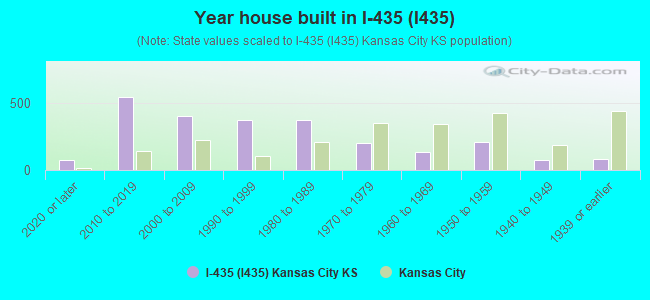
- Year house built in I-435 <
> - 722020 or later
- 5402010 to 2019
- 3992000 to 2009
- 3681990 to 1999
- 3711980 to 1989
- 1981970 to 1979
- 1311960 to 1969
- 2051950 to 1959
- 721940 to 1949
- 811939 or earlier
City-data.com crime index for city in 2015 (higher means more crime):
| City: | 553.9 |
| U.S. average: | 243.4 |
Travel time to work (commute)
![Travel time to work (commute)]()
- 66Less than 5 minutes
- 3745 to 9 minutes
- 78110 to 14 minutes
- 63615 to 19 minutes
- 1,21520 to 24 minutes
- 78325 to 29 minutes
- 77230 to 34 minutes
- 21735 to 39 minutes
- 4940 to 44 minutes
- 14545 to 59 minutes
- 14060 to 89 minutes
- 6790 or more minutes

Means of transportation to work
![Means of transportation to work]()
- 80.7%2,650Drove a car alone
- 3.7%123Carpooled
- 1.9%61Bus
- 3.3%107Ferryboat
- 0.6%21Taxi
- 31.6%1,039Motorcycle
- 0.4%13Walked
- 4.5%147Other means
- 15.8%518Worked at home

Time leaving home to go to work
![Time leaving home to go to work]()
- 14712:00 a.m. to 4:59 a.m.
- 3415:00 a.m. to 5:29 a.m.
- 1325:30 a.m. to 5:59 a.m.
- 4796:00 a.m. to 6:29 a.m.
- 5096:30 a.m. to 6:59 a.m.
- 8967:00 a.m. to 7:29 a.m.
- 8227:30 a.m. to 7:59 a.m.
- 7208:00 a.m. to 8:29 a.m.
- 1408:30 a.m. to 8:59 a.m.
- 1809:00 a.m. to 9:59 a.m.
- 10910:00 a.m. to 10:59 a.m.
- 4911:00 a.m. to 11:59 a.m.
- 33012:00 p.m. to 3:59 p.m.
- 3684:00 p.m. to 11:59 p.m.

Occupations of males:
- Percentage of males in management occupations (except farmers):
Here: 9.1% city: 7.1%
- Percentage of males in business and financial operations occupations:
Here: 3.8% city: 2.4%
- Percentage of males in computer and mathematical occupations:
Here: 12.2% city: 3.3%
- Percentage of males in architecture and engineering occupations:
Here: 5.3% city: 1.7%
- Percentage of males in legal occupations:
Here: 1.5% city: 0.4%
- Percentage of males in education, training, and library occupations:
Here: 3.9% city: 2.0%
- Percentage of males in arts, design, entertainment, sports, and media occupations:
Here: 1.5% city: 0.4%
- Percentage of males in healthcare practitioners and technical occupations:
Here: 4.2% city: 2.1%
- Percentage of males in service occupations:
Here: 21.7% city: 14.6%
- Percentage of males in sales and office occupations:
Here: 14.6% city: 10.9%
- Percentage of males in construction, extraction, and maintenance occupations:
Here: 5.1% city: 15.4%
- Percentage of males in production occupations:
Here: 6.0% city: 11.9%
- Percentage of males in material moving occupations:
Here: 6.0% city: 12.2%
Occupations of females:
- Percentage of females in management occupations (except farmers):
Here: 7.4% city: 6.8%
- Percentage of females in business and financial operations occupations:
Here: 5.7% city: 5.3%
- Percentage of females in community and social services occupations:
Here: 4.3% city: 2.3%
- Percentage of females in legal occupations:
Here: 1.8% city: 0.9%
- Percentage of females in education, training, and library occupations:
Here: 11.7% city: 7.0%
- Percentage of females in arts, design, entertainment, sports, and media occupations:
Here: 4.0% city: 1.4%
- Percentage of females in healthcare practitioners and technical occupations:
Here: 9.0% city: 6.3%
- Percentage of females in service occupations:
Here: 14.1% city: 22.4%
- Percentage of females in sales and office occupations:
Here: 38.4% city: 28.6%
- Percentage of females in material moving occupations:
Here: 2.2% city: 5.5%
Percentage of people 16-64 in Armed Forces:
| I-435 (I435): | 0.6% |
| Kansas City: | 0.4% |
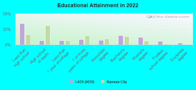
Education in this neighborhood (subdivision or community):
- Percentage of people 3 years and older in K-12 schools:
I-435 (I435): 23.7% Kansas City: 20.0%
- Percentage of people 3 years and older in undergraduate colleges:
I-435 (I435): 8.6% Kansas City: 3.8%
- Percentage of people 3 years and older in grad. or professional schools:
I-435 (I435): 4.2% Kansas City: 2.1%
- Percentage of students K-12 enrolled in private schools:
I-435 (I435): 79.7% Kansas City: 12.7%
Percentage of population below poverty level:
| I-435 (I435): | 3.3% |
| Kansas City: | 14.3% |
Percentage of married-couple families with both working:
| I-435 (I435): | 91.6% |
| Kansas City: | 69.9% |
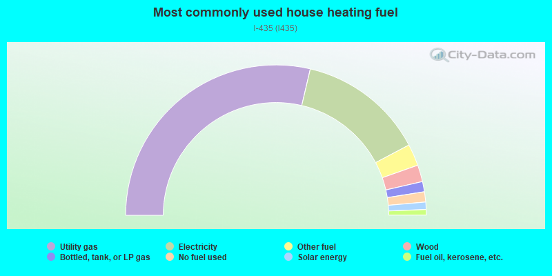
- 57.4%Utility gas
- 27.2%Electricity
- 4.7%Other fuel
- 3.6%Wood
- 2.2%Bottled, tank, or LP gas
- 2.2%No fuel used
- 1.6%Solar energy
- 1.2%Fuel oil, kerosene, etc.
Limited-access highways (interstate or state) in this neighborhood:
State Hwy 5 (I- 435)
Length: 12.25 miles
Directions: N-S, SE-NW, SW-NE
Directions: N-S, SE-NW, SW-NE
Eisenhower Memorial Hwy (I- 70)
Length: 4.44 miles
Direction: E-W
Direction: E-W
Highways in this neighborhood:
State Ave (US Hwy 24, US Hwy 73, US Hwy 40)
Length: 5.27 miles
Directions: E-W, N-S, SE-NW, SW-NE
Address range: 8992 to 10405
Directions: E-W, N-S, SE-NW, SW-NE
Address range: 8992 to 10405
State Hwy 5
Length: 0.75 miles
Directions: N-S, SE-NW, SW-NE
Directions: N-S, SE-NW, SW-NE
State Hwy 5 (Wolcott Dr)
Length: 0.18 miles
Direction: SE-NW
Direction: SE-NW
State Hwy 5 (97th St)
Length: 0.09 miles
Direction: N-S
Direction: N-S
Roads and streets:
N 107 St (N 107th St)
Length: 4.16 miles
Directions: N-S, SE-NW, SW-NE
Address range: 2500 to 6299
Directions: N-S, SE-NW, SW-NE
Address range: 2500 to 6299
Georgia Ave
Length: 3.44 miles
Directions: E-W, SE-NW, SW-NE
Address range: 9201 to 11399
Directions: E-W, SE-NW, SW-NE
Address range: 9201 to 11399
Leavenworth Rd
Length: 3.37 miles
Directions: E-W, N-S, SE-NW
Address range: 9100 to 11203
Directions: E-W, N-S, SE-NW
Address range: 9100 to 11203
Parallel Pkwy
Length: 3.34 miles
Directions: E-W, N-S, SE-NW
Address range: 9200 to 11101
Directions: E-W, N-S, SE-NW
Address range: 9200 to 11101
Hutton Rd
Length: 3.22 miles
Directions: E-W, N-S, SW-NE
Address range: 2000 to 10483
Directions: E-W, N-S, SW-NE
Address range: 2000 to 10483
Daytona Dr
Length: 2.72 miles
Directions: E-W, N-S, SE-NW, SW-NE
Directions: E-W, N-S, SE-NW, SW-NE
Hollingsworth Rd
Length: 2.64 miles
Directions: E-W, N-S, SW-NE
Address range: 9752 to 11299
Directions: E-W, N-S, SW-NE
Address range: 9752 to 11299
Donahoo Rd
Length: 2.64 miles
Directions: E-W, N-S, SE-NW, SW-NE
Address range: 9800 to 11459
Directions: E-W, N-S, SE-NW, SW-NE
Address range: 9800 to 11459
West Dr
Length: 2.57 miles
Directions: E-W, N-S, SE-NW, SW-NE
Address range: 3438 to 5107
Directions: E-W, N-S, SE-NW, SW-NE
Address range: 3438 to 5107
N 99 St (N 99th St)
Length: 2.32 miles
Directions: E-W, N-S, SE-NW, SW-NE
Address range: 1824 to 5499
Directions: E-W, N-S, SE-NW, SW-NE
Address range: 1824 to 5499
Nelson Ln
Length: 1.78 miles
Directions: E-W, SW-NE
Address range: 4000 to 10531
Directions: E-W, SW-NE
Address range: 4000 to 10531
Wy Co Lake Park Rd
Length: 1.75 miles
Directions: E-W, N-S, SE-NW, SW-NE
Directions: E-W, N-S, SE-NW, SW-NE
N 94 St (N 94th St)
Length: 1.61 miles
Directions: E-W, N-S, SW-NE
Address range: 464 to 1999
Directions: E-W, N-S, SW-NE
Address range: 464 to 1999
N 98 St (N 98th St)
Length: 1.55 miles
Direction: N-S
Address range: 452 to 1999
Direction: N-S
Address range: 452 to 1999
N 110 St (N 110th St)
Length: 1.45 miles
Directions: E-W, N-S, SE-NW, SW-NE
Address range: 1500 to 4217
Directions: E-W, N-S, SE-NW, SW-NE
Address range: 1500 to 4217
Independence Blvd
Length: 1.41 miles
Directions: E-W, N-S, SE-NW, SW-NE
Address range: 3912 to 11199
Directions: E-W, N-S, SE-NW, SW-NE
Address range: 3912 to 11199
N 97th St
Length: 1.41 miles
Directions: N-S, SE-NW, SW-NE
Address range: 3800 to 5451
Directions: N-S, SE-NW, SW-NE
Address range: 3800 to 5451
N 93 St (N 93rd St)
Length: 1.31 miles
Directions: N-S, SE-NW, SW-NE
Address range: 4500 to 5251
Directions: N-S, SE-NW, SW-NE
Address range: 4500 to 5251
Village West Pkwy (N Village West Pkwy)
Length: 1.29 miles
Directions: E-W, N-S, SE-NW, SW-NE
Directions: E-W, N-S, SE-NW, SW-NE
Hubbard Rd
Length: 1.28 miles
Direction: E-W
Address range: 1113 to 11499
Direction: E-W
Address range: 1113 to 11499
Hurrelbrink Rd
Length: 1.21 miles
Directions: E-W, SE-NW
Address range: 9200 to 9899
Directions: E-W, SE-NW
Address range: 9200 to 9899
N 109 St (N 109th St)
Length: 1.16 miles
Directions: E-W, N-S, SE-NW, SW-NE
Address range: 2000 to 10899
Directions: E-W, N-S, SE-NW, SW-NE
Address range: 2000 to 10899
N 115 St (N 115th St)
Length: 1.04 miles
Directions: N-S, SW-NE
Address range: 5101 to 5911
Directions: N-S, SW-NE
Address range: 5101 to 5911
Way Co Lake Park Rd
Length: 0.98 miles
Directions: E-W, N-S, SE-NW, SW-NE
Directions: E-W, N-S, SE-NW, SW-NE
Sam Clark Ln
Length: 0.98 miles
Directions: E-W, SE-NW, SW-NE
Address range: 10988 to 11499
Directions: E-W, SE-NW, SW-NE
Address range: 10988 to 11499
N 90 St (N 90th St)
Length: 0.95 miles
Directions: N-S, SE-NW, SW-NE
Address range: 700 to 1873
Directions: N-S, SE-NW, SW-NE
Address range: 700 to 1873
California Dr
Length: 0.95 miles
Directions: E-W, N-S, SW-NE
Directions: E-W, N-S, SW-NE
N 97 St (Donahoo Rd)
Length: 0.92 miles
Directions: E-W, N-S, SE-NW, SW-NE
Address range: 9700 to 9899
Directions: E-W, N-S, SE-NW, SW-NE
Address range: 9700 to 9899
France Family Dr
Length: 0.92 miles
Directions: E-W, SW-NE
Address range: 10110 to 10199
Directions: E-W, SW-NE
Address range: 10110 to 10199
N 109 Ter (N 109th Ter)
Length: 0.91 miles
Directions: E-W, N-S, SE-NW, SW-NE
Address range: 2500 to 4256
Directions: E-W, N-S, SE-NW, SW-NE
Address range: 2500 to 4256
N 102 St (N 102nd St)
Length: 0.90 miles
Directions: E-W, N-S, SE-NW, SW-NE
Address range: 2200 to 2899
Directions: E-W, N-S, SE-NW, SW-NE
Address range: 2200 to 2899
Winchester Dr
Length: 0.82 miles
Directions: E-W, N-S, SE-NW
Address range: 11200 to 11399
Directions: E-W, N-S, SE-NW
Address range: 11200 to 11399
Haskell Ave
Length: 0.79 miles
Directions: E-W, N-S, SE-NW
Address range: 10200 to 10599
Directions: E-W, N-S, SE-NW
Address range: 10200 to 10599
N 103 Ter (N 103rd Ter)
Length: 0.71 miles
Directions: N-S, SE-NW, SW-NE
Directions: N-S, SE-NW, SW-NE
Old State Hwy 5
Length: 0.70 miles
Direction: SE-NW
Direction: SE-NW
Cleveland Ave
Length: 0.69 miles
Directions: E-W, N-S, SE-NW, SW-NE
Address range: 10500 to 11099
Directions: E-W, N-S, SE-NW, SW-NE
Address range: 10500 to 11099
N 86 St (N 86th St)
Length: 0.65 miles
Direction: N-S
Address range: 330 to 909
Direction: N-S
Address range: 330 to 909
N 111 St (N 111th St)
Length: 0.64 miles
Directions: E-W, N-S, SE-NW, SW-NE
Address range: 3200 to 3399
Directions: E-W, N-S, SE-NW, SW-NE
Address range: 3200 to 3399
N 91 St (N 91st St)
Length: 0.62 miles
Direction: N-S
Address range: 2830 to 3253
Direction: N-S
Address range: 2830 to 3253
Americrown Dr
Length: 0.58 miles
Directions: N-S, SW-NE
Directions: N-S, SW-NE
Darlington Dr
Length: 0.55 miles
Directions: E-W, SE-NW
Directions: E-W, SE-NW
Tuscon Dr
Length: 0.53 miles
Direction: E-W
Direction: E-W
N 93rd Ln (N 93rd St)
Length: 0.50 miles
Directions: N-S, SE-NW
Address range: 4200 to 4499
Directions: N-S, SE-NW
Address range: 4200 to 4499
Ann Ave
Length: 0.49 miles
Directions: E-W, SE-NW
Address range: 8800 to 9199
Directions: E-W, SE-NW
Address range: 8800 to 9199
N 112 St (N 112th St)
Length: 0.49 miles
Directions: E-W, N-S, SE-NW, SW-NE
Address range: 3800 to 3899
Directions: E-W, N-S, SE-NW, SW-NE
Address range: 3800 to 3899
Talladega Dr
Length: 0.49 miles
Direction: E-W
Direction: E-W
Nazareth Dr
Length: 0.49 miles
Direction: E-W
Direction: E-W
N 110 Ter (N 110th Ter)
Length: 0.48 miles
Directions: E-W, N-S, SE-NW, SW-NE
Address range: 2700 to 2831
Directions: E-W, N-S, SE-NW, SW-NE
Address range: 2700 to 2831
New Jersey Ave
Length: 0.47 miles
Direction: E-W
Address range: 9800 to 10109
Direction: E-W
Address range: 9800 to 10109
N 108 St (108th St)
Length: 0.45 miles
Directions: E-W, N-S, SE-NW, SW-NE
Address range: 5101 to 5399
Directions: E-W, N-S, SE-NW, SW-NE
Address range: 5101 to 5399
Homestead-Miami Dr
Length: 0.45 miles
Directions: E-W, SE-NW
Directions: E-W, SE-NW
N 118 St (N 118th St)
Length: 0.44 miles
Direction: N-S
Address range: 1134 to 1621
Direction: N-S
Address range: 1134 to 1621
N Miller Ln
Length: 0.43 miles
Directions: E-W, N-S, SE-NW
Address range: 10700 to 10999
Directions: E-W, N-S, SE-NW
Address range: 10700 to 10999
Sloan Ave
Length: 0.43 miles
Directions: E-W, N-S, SE-NW, SW-NE
Address range: 9929 to 11199
Directions: E-W, N-S, SE-NW, SW-NE
Address range: 9929 to 11199
Walcott Dr
Length: 0.42 miles
Directions: E-W, N-S, SE-NW, SW-NE
Directions: E-W, N-S, SE-NW, SW-NE
Parkview Ave
Length: 0.42 miles
Directions: E-W, N-S, SE-NW, SW-NE
Address range: 9900 to 11199
Directions: E-W, N-S, SE-NW, SW-NE
Address range: 9900 to 11199
N 106 St (106th St)
Length: 0.40 miles
Directions: N-S, SW-NE
Address range: 2500 to 2599
Directions: N-S, SW-NE
Address range: 2500 to 2599
Countryside Dr
Length: 0.35 miles
Directions: E-W, N-S, SE-NW, SW-NE
Address range: 5204 to 10899
Directions: E-W, N-S, SE-NW, SW-NE
Address range: 5204 to 10899
Splitlog Ave
Length: 0.33 miles
Directions: E-W, SW-NE
Address range: 8600 to 8850
Directions: E-W, SW-NE
Address range: 8600 to 8850
N 107 Ter (N 107th Ter)
Length: 0.32 miles
Directions: E-W, N-S, SE-NW, SW-NE
Address range: 2400 to 2699
Directions: E-W, N-S, SE-NW, SW-NE
Address range: 2400 to 2699
Meeks Rd
Length: 0.32 miles
Direction: E-W
Address range: 9700 to 9999
Direction: E-W
Address range: 9700 to 9999
Richmond Dr
Length: 0.31 miles
Direction: SE-NW
Direction: SE-NW
N 113 St (113th St, N 113th St)
Length: 0.30 miles
Directions: E-W, N-S, SE-NW, SW-NE
Address range: 3700 to 3899
Directions: E-W, N-S, SE-NW, SW-NE
Address range: 3700 to 3899
N 92 St (Ann Ave)
Length: 0.30 miles
Directions: N-S, SE-NW, SW-NE
Address range: 934 to 1099
Directions: N-S, SE-NW, SW-NE
Address range: 934 to 1099
Chicagoland Dr
Length: 0.29 miles
Direction: SE-NW
Direction: SE-NW
Rowland Ct
Length: 0.28 miles
Directions: E-W, N-S, SE-NW, SW-NE
Address range: 10700 to 10899
Directions: E-W, N-S, SE-NW, SW-NE
Address range: 10700 to 10899
Rowland Ave
Length: 0.28 miles
Directions: E-W, N-S, SE-NW, SW-NE
Address range: 10500 to 10699
Directions: E-W, N-S, SE-NW, SW-NE
Address range: 10500 to 10699
Edith Ave
Length: 0.27 miles
Direction: E-W
Address range: 9900 to 9999
Direction: E-W
Address range: 9900 to 9999
N 104 Ter (N 104th Ter)
Length: 0.27 miles
Directions: N-S, SE-NW
Address range: 2000 to 2399
Directions: N-S, SE-NW
Address range: 2000 to 2399
Minnesota Ave
Length: 0.26 miles
Direction: E-W
Address range: 9200 to 9399
Direction: E-W
Address range: 9200 to 9399
Webster Ave
Length: 0.25 miles
Directions: E-W, SE-NW
Address range: 10100 to 10399
Directions: E-W, SE-NW
Address range: 10100 to 10399
Armstrong Ave
Length: 0.22 miles
Directions: E-W, SW-NE
Address range: 8800 to 9099
Directions: E-W, SW-NE
Address range: 8800 to 9099
Phoenix Dr
Length: 0.22 miles
Directions: N-S, SE-NW
Directions: N-S, SE-NW
Polfer Rd
Length: 0.22 miles
Directions: E-W, SE-NW, SW-NE
Address range: 10500 to 10699
Directions: E-W, SE-NW, SW-NE
Address range: 10500 to 10699
Lakeview Dr
Length: 0.21 miles
Directions: E-W, SW-NE
Address range: 11100 to 11399
Directions: E-W, SW-NE
Address range: 11100 to 11399
N 103 St (103rd St, N 103rd St)
Length: 0.20 miles
Directions: E-W, N-S, SE-NW, SW-NE
Address range: 2714 to 2899
Directions: E-W, N-S, SE-NW, SW-NE
Address range: 2714 to 2899
Hutton Rd (N 109th St)
Length: 0.19 miles
Directions: N-S, SW-NE
Address range: 2600 to 2699
Directions: N-S, SW-NE
Address range: 2600 to 2699
Michigan Dr
Length: 0.19 miles
Directions: N-S, SW-NE
Directions: N-S, SW-NE
Main St
Length: 0.19 miles
Direction: SW-NE
Direction: SW-NE
N 100 Ter (N 100th Ter)
Length: 0.18 miles
Directions: E-W, N-S, SE-NW
Address range: 2100 to 2104
Directions: E-W, N-S, SE-NW
Address range: 2100 to 2104
Elm St
Length: 0.18 miles
Direction: SW-NE
Direction: SW-NE
N 113 Ct (N 113th Ct)
Length: 0.18 miles
Directions: E-W, N-S, SE-NW, SW-NE
Directions: E-W, N-S, SE-NW, SW-NE
Bent Tree Dr
Length: 0.18 miles
Directions: E-W, N-S, SE-NW
Address range: 11200 to 11299
Directions: E-W, N-S, SE-NW
Address range: 11200 to 11299
Liggett Rd
Length: 0.17 miles
Direction: E-W
Address range: 9100 to 9299
Direction: E-W
Address range: 9100 to 9299
N 100 St (100th St, N 100th St)
Length: 0.17 miles
Directions: N-S, SE-NW
Address range: 3216 to 3399
Directions: N-S, SE-NW
Address range: 3216 to 3399
Co Lake Park Rd
Length: 0.16 miles
Directions: E-W, N-S, SE-NW
Directions: E-W, N-S, SE-NW
Nebraska Ave
Length: 0.16 miles
Directions: E-W, N-S, SE-NW, SW-NE
Directions: E-W, N-S, SE-NW, SW-NE
Canaan Valley Dr
Length: 0.16 miles
Directions: E-W, N-S, SE-NW
Address range: 3100 to 3199
Directions: E-W, N-S, SE-NW
Address range: 3100 to 3199
McGurk Rd
Length: 0.16 miles
Direction: E-W
Address range: 9800 to 9899
Direction: E-W
Address range: 9800 to 9899
N 111 Ter (N 111th Ter)
Length: 0.15 miles
Directions: E-W, N-S, SE-NW, SW-NE
Address range: 3100 to 3299
Directions: E-W, N-S, SE-NW, SW-NE
Address range: 3100 to 3299
Sortor Dr
Length: 0.15 miles
Directions: E-W, SE-NW
Address range: 11100 to 11399
Directions: E-W, SE-NW
Address range: 11100 to 11399
Longwood Ave
Length: 0.15 miles
Directions: E-W, N-S, SE-NW
Address range: 9900 to 10299
Directions: E-W, N-S, SE-NW
Address range: 9900 to 10299
N 105 St (N 105th St)
Length: 0.15 miles
Directions: E-W, N-S, SE-NW, SW-NE
Address range: 2700 to 2799
Directions: E-W, N-S, SE-NW, SW-NE
Address range: 2700 to 2799
Barnett Ave
Length: 0.15 miles
Directions: E-W, N-S, SE-NW, SW-NE
Address range: 9000 to 9099
Directions: E-W, N-S, SE-NW, SW-NE
Address range: 9000 to 9099
Wingfoot Dr
Length: 0.14 miles
Directions: E-W, N-S, SE-NW, SW-NE
Directions: E-W, N-S, SE-NW, SW-NE
N 89 St (N 89th St)
Length: 0.14 miles
Directions: N-S, SW-NE
Address range: 801 to 914
Directions: N-S, SW-NE
Address range: 801 to 914
Nogard Ave
Length: 0.14 miles
Directions: E-W, N-S, SE-NW, SW-NE
Address range: 10500 to 10599
Directions: E-W, N-S, SE-NW, SW-NE
Address range: 10500 to 10599
Everett Ave
Length: 0.13 miles
Directions: E-W, SE-NW
Address range: 9200 to 9399
Directions: E-W, SE-NW
Address range: 9200 to 9399
N 95 St (N 95th St)
Length: 0.13 miles
Direction: N-S
Address range: 2400 to 2499
Direction: N-S
Address range: 2400 to 2499
Speedway Blvd
Length: 0.12 miles
Directions: E-W, SE-NW
Directions: E-W, SE-NW
Oak Dr
Length: 0.12 miles
Directions: E-W, N-S, SE-NW, SW-NE
Address range: 10900 to 10999
Directions: E-W, N-S, SE-NW, SW-NE
Address range: 10900 to 10999
Cabela Dr
Length: 0.12 miles
Direction: E-W
Direction: E-W
Yecker Ave
Length: 0.12 miles
Directions: E-W, SE-NW
Address range: 10200 to 10227
Directions: E-W, SE-NW
Address range: 10200 to 10227
North Carolina Dr
Length: 0.11 miles
Direction: N-S
Direction: N-S
N 92 Ter (N 92nd Ter)
Length: 0.11 miles
Directions: E-W, N-S, SE-NW, SW-NE
Address range: 1300 to 1399
Directions: E-W, N-S, SE-NW, SW-NE
Address range: 1300 to 1399
Greeley Ave
Length: 0.11 miles
Direction: E-W
Direction: E-W
K-5 Hwy
Length: 0.11 miles
Direction: SE-NW
Direction: SE-NW
N 102 Ter (N 102nd Ter)
Length: 0.10 miles
Directions: E-W, N-S, SE-NW, SW-NE
Address range: 2800 to 2899
Directions: E-W, N-S, SE-NW, SW-NE
Address range: 2800 to 2899
Watkins Glen Dr
Length: 0.10 miles
Direction: N-S
Direction: N-S
Kimball Ave
Length: 0.10 miles
Direction: E-W
Address range: 10900 to 11099
Direction: E-W
Address range: 10900 to 11099
Wagon Trail St
Length: 0.10 miles
Direction: E-W
Address range: 10900 to 10918
Direction: E-W
Address range: 10900 to 10918
N 101 Ter (N 101st Ter, W 101st Ter)
Length: 0.09 miles
Directions: E-W, N-S, SE-NW, SW-NE
Address range: 2700 to 2799
Directions: E-W, N-S, SE-NW, SW-NE
Address range: 2700 to 2799
N 112 Ter (N 112th Ter)
Length: 0.09 miles
Directions: E-W, N-S, SE-NW, SW-NE
Address range: 3800 to 3899
Directions: E-W, N-S, SE-NW, SW-NE
Address range: 3800 to 3899
N 111th St (N 111th Ter)
Length: 0.09 miles
Directions: E-W, N-S, SW-NE
Address range: 2500 to 2599
Directions: E-W, N-S, SW-NE
Address range: 2500 to 2599
Angle Ct
Length: 0.08 miles
Directions: E-W, N-S, SE-NW, SW-NE
Address range: 11100 to 11199
Directions: E-W, N-S, SE-NW, SW-NE
Address range: 11100 to 11199
Parallel
Length: 0.08 miles
Direction: N-S
Address range: 10026 to 10112
Direction: N-S
Address range: 10026 to 10112
N 89 Ct (89th Ct)
Length: 0.07 miles
Directions: E-W, N-S, SE-NW, SW-NE
Address range: 800 to 899
Directions: E-W, N-S, SE-NW, SW-NE
Address range: 800 to 899
N 96 Ter (96th Ter)
Length: 0.07 miles
Direction: SE-NW
Direction: SE-NW
Wyandotte County Lake Entrance
Length: 0.07 miles
Direction: E-W
Direction: E-W
Grouse Dr
Length: 0.06 miles
Directions: E-W, N-S
Directions: E-W, N-S
N 96 St (96th St)
Length: 0.06 miles
Direction: SE-NW
Direction: SE-NW
N 99 Ter (99th Ter, N 99th Ter)
Length: 0.05 miles
Direction: N-S
Address range: 3200 to 3299
Direction: N-S
Address range: 3200 to 3299
State Ave Lp
Length: 0.05 miles
Directions: E-W, SE-NW, SW-NE
Directions: E-W, SE-NW, SW-NE
N 112 Ct (N 112th Ct)
Length: 0.05 miles
Direction: SW-NE
Direction: SW-NE
N 100th Ter
Length: 0.05 miles
Direction: E-W
Direction: E-W
Access Rd
Length: 0.05 miles
Direction: N-S
Direction: N-S
N 99th St
Length: 0.04 miles
Directions: E-W, SE-NW
Address range: 4300 to 4399
Directions: E-W, SE-NW
Address range: 4300 to 4399
Lakeside Dr
Length: 0.04 miles
Directions: E-W, SE-NW
Directions: E-W, SE-NW
Parallel Pkwy Lp
Length: 0.04 miles
Directions: E-W, N-S, SE-NW, SW-NE
Directions: E-W, N-S, SE-NW, SW-NE
N 114 St (114th St)
Length: 0.03 miles
Direction: N-S
Direction: N-S
Wagon Trail Dr
Length: 0.03 miles
Directions: E-W, SW-NE
Directions: E-W, SW-NE
N 92nd St
Length: 0.03 miles
Direction: SE-NW
Address range: 900 to 933
Direction: SE-NW
Address range: 900 to 933
N 109th Ter
Length: 0.02 miles
Direction: E-W
Address range: 2591 to 2600
Direction: E-W
Address range: 2591 to 2600
Other features:
Connor Crk
Length: 6.72 miles
Directions: E-W, N-S, SE-NW, SW-NE
Directions: E-W, N-S, SE-NW, SW-NE
Honey Crk
Length: 3.11 miles
Directions: E-W, N-S, SE-NW, SW-NE
Directions: E-W, N-S, SE-NW, SW-NE
Marshall Crk
Length: 2.93 miles
Directions: E-W, N-S, SE-NW, SW-NE
Directions: E-W, N-S, SE-NW, SW-NE
Little Turkey Crk
Length: 2.09 miles
Directions: E-W, N-S, SE-NW, SW-NE
Directions: E-W, N-S, SE-NW, SW-NE
Island Crk
Length: 1.95 miles
Directions: E-W, N-S, SE-NW, SW-NE
Directions: E-W, N-S, SE-NW, SW-NE