Johnsons Station neighborhood in Arlington, Texas (TX), 76015, 76017 detailed profile
Settings
X


Business Search - 14 Million verified businesses
Area: 3.041 square miles
Population: 5,874
Population density:
| Johnsons Station: | 1,931 people per square mile |
| Arlington: | 4,118 people per square mile |

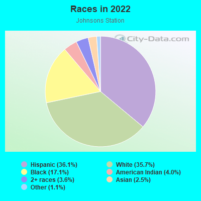
- 2,22436.1%Hispanic or Latino
- 2,19735.7%White
- 1,05517.1%Black
- 2464.0%American Indian
- 2223.6%Two or more races
- 1512.5%Asian
- 651.1%Some other race
Distribution of median household income
![Distribution of median household income]()
- 450Less than $10,000
- 453$10,000 to $19,999
- 265$20,000 to $29,999
- 135$30,000 to $39,999
- 138$40,000 to $49,999
- 63$50,000 to $59,999
- 264$60,000 to $74,999
- 291$75,000 to $99,999
- 294$100,000 to $124,999
- 200$125,000 to $149,999
- 138$150,000 to $199,999
- 65$200,000 or more

Distribution of owner-occupied house/condo value
![Distribution of owner-occupied house/condo value]()
- 594Less than $50,000
- 397$50,000 to $99,999
- 208$100,000 to $149,999
- 341$150,000 to $199,999
- 254$200,000 to $249,999
- 157$250,000 to $299,999
- 147$300,000 to $399,999
- 142$400,000 to $499,999
- 70$500,000 to $749,999
- 38$750,000 to $999,999

Distribution of rent paid by renters
![Distribution of rent paid by renters]()
- 47$100 to $199
- 74$200 to $299
- 123$300 to $399
- 16$400 to $499
- 77$500 to $599
- 342$600 to $699
- 690$700 to $799
- 505$800 to $899
- 101$900 to $999
- 132$1,000 to $1,249
- 104$1,250 to $1,499
- 222$1,500 to $1,999
- 125$2,000 or more

| Males: | 3,027 |
| Females: | 2,847 |
Males:
| This neighborhood: | |
| Whole city: |
| This neighborhood: | |
| Whole city: |
Percentage of family households:
| Johnsons Station: | 54.0% |
| Arlington: | 49.5% |
| Here: | 57.2% |
| Arlington: | 43.9% |
Percentage of married-couple families with children (among all households):
| Johnsons Station: | 18.6% |
| Arlington: | 23.1% |
Percentage of single-mother households (among all households):
| Johnsons Station: | 7.5% |
| Arlington: | 8.5% |
Percentage of never married males 15 years old and over:
Percentage of never married females 15 years old and over:
| Johnsons Station: | 25.4% |
| Arlington: | 20.6% |
Percentage of never married females 15 years old and over:
| Johnsons Station: | 17.2% |
| city: | 19.7% |
Percentage of people that speak English not well or not at all:
| Johnsons Station: | 4.6% |
| Arlington: | 6.6% |
Percentage of people born in this state:
Percentage of people born in another U.S. state:
Percentage of native residents but born outside the U.S.:
Percentage of foreign born residents:
| Here: | 55.9% |
| Arlington: | 50.9% |
Percentage of people born in another U.S. state:
| Johnsons Station: | 24.6% |
| Arlington: | 25.9% |
Percentage of native residents but born outside the U.S.:
| Here: | 0.7% |
| city: | 1.9% |
Percentage of foreign born residents:
| Here: | 18.8% |
| Arlington: | 21.3% |
Owner-occupied
Renter-occupied

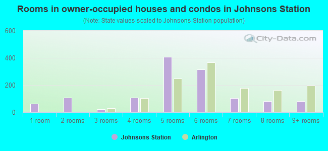
- Rooms in owner-occupied houses and condos in Johnsons Station
- 621 room
- 1082 rooms
- 213 rooms
- 1064 rooms
- 4075 rooms
- 3156 rooms
- 1037 rooms
- 818 rooms
- 839+ rooms
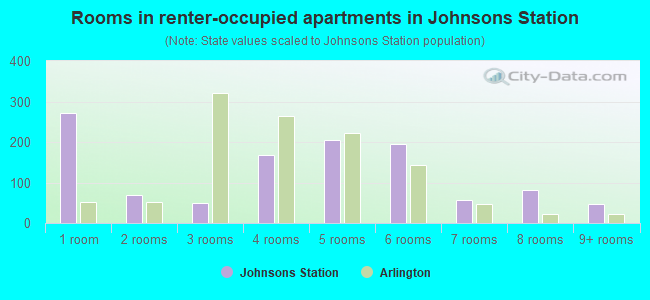
- Rooms in renter-occupied apartments in Johnsons Station
- 2711 room
- 692 rooms
- 503 rooms
- 1694 rooms
- 2065 rooms
- 1956 rooms
- 567 rooms
- 828 rooms
- 479+ rooms
Owner-occupied
Renter-occupied
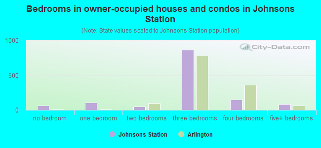
- Bedrooms in owner-occupied houses and condos in Johnsons Station
- 62no bedroom
- 1081 bedroom
- 512 bedrooms
- 8633 bedrooms
- 1514 bedrooms
- 845+ bedrooms
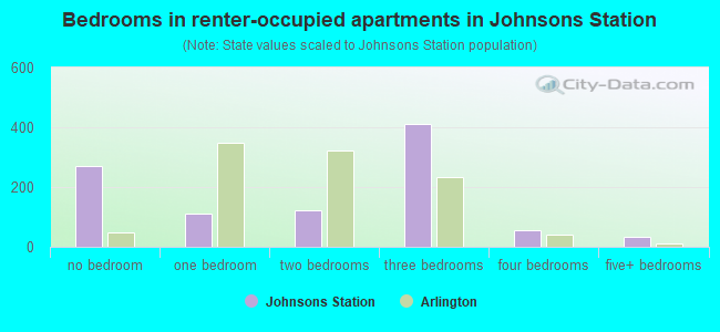
- Bedrooms in renter-occupied apartments in Johnsons Station
- 271no bedroom
- 1121 bedroom
- 1222 bedrooms
- 4123 bedrooms
- 554 bedrooms
- 335+ bedrooms
Average number of cars or other vehicles available in houses/condos:
Average number of cars or other vehicles available in apartments:
| This neighborhood: | |
| Arlington: |
Average number of cars or other vehicles available in apartments:
| Here: | |
| city: |
Percentage of units with a mortgage:
| Johnsons Station: | 57.7% |
| Arlington: | 60.9% |
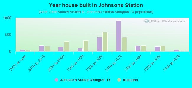
- Year house built in Johnsons Station
- 552020 or later
- 1762010 to 2019
- 1362000 to 2009
- 931990 to 1999
- 4341980 to 1989
- 9291970 to 1979
- 1641960 to 1969
- 1451950 to 1959
- 541940 to 1949
- 01939 or earlier
City-data.com crime index for city in 2020 (higher means more crime):
| City: | 285.6 |
| U.S. average: | 219.5 |
Travel time to work (commute)
![Travel time to work (commute)]()
- 19Less than 5 minutes
- 4725 to 9 minutes
- 57410 to 14 minutes
- 44715 to 19 minutes
- 59520 to 24 minutes
- 29325 to 29 minutes
- 65430 to 34 minutes
- 11835 to 39 minutes
- 14440 to 44 minutes
- 30145 to 59 minutes
- 11960 to 89 minutes
- 2790 or more minutes

Means of transportation to work
![Means of transportation to work]()
- 72.7%2,103Drove a car alone
- 9.7%280Carpooled
- 0.6%17Motorcycle
- 3.1%91Walked
- 3.8%110Other means
- 12.8%369Worked at home

Time leaving home to go to work
![Time leaving home to go to work]()
- 22412:00 a.m. to 4:59 a.m.
- 1005:00 a.m. to 5:29 a.m.
- 2835:30 a.m. to 5:59 a.m.
- 3516:00 a.m. to 6:29 a.m.
- 1886:30 a.m. to 6:59 a.m.
- 5657:00 a.m. to 7:29 a.m.
- 3447:30 a.m. to 7:59 a.m.
- 3398:00 a.m. to 8:29 a.m.
- 1108:30 a.m. to 8:59 a.m.
- 2829:00 a.m. to 9:59 a.m.
- 25610:00 a.m. to 10:59 a.m.
- 9211:00 a.m. to 11:59 a.m.
- 30212:00 p.m. to 3:59 p.m.
- 2854:00 p.m. to 11:59 p.m.

Occupations of males:
- Percentage of males in management occupations (except farmers):
Here: 8.2% city: 8.8%
- Percentage of males in business and financial operations occupations:
Here: 3.3% city: 4.5%
- Percentage of males in computer and mathematical occupations:
Here: 3.1% city: 4.4%
- Percentage of males in life, physical, and social science occupations:
Here: 3.7% city: 0.7%
- Percentage of males in education, training, and library occupations:
Here: 1.6% city: 3.7%
- Percentage of males in healthcare practitioners and technical occupations:
Here: 1.6% city: 2.2%
- Percentage of males in service occupations:
Here: 14.9% city: 12.9%
- Percentage of males in sales and office occupations:
Here: 19.2% city: 17.0%
- Percentage of males in construction, extraction, and maintenance occupations:
Here: 9.0% city: 10.8%
- Percentage of males in production occupations:
Here: 3.3% city: 8.0%
- Percentage of males in transportation occupations:
Here: 9.6% city: 7.6%
- Percentage of males in material moving occupations:
Here: 13.6% city: 7.5%
Occupations of females:
- Percentage of females in management occupations (except farmers):
Here: 8.0% city: 9.3%
- Percentage of females in business and financial operations occupations:
Here: 6.9% city: 6.1%
- Percentage of females in architecture and engineering occupations:
Here: 1.0% city: 0.6%
- Percentage of females in community and social services occupations:
Here: 4.1% city: 2.5%
- Percentage of females in education, training, and library occupations:
Here: 5.6% city: 9.2%
- Percentage of females in healthcare practitioners and technical occupations:
Here: 5.5% city: 7.2%
- Percentage of females in service occupations:
Here: 21.6% city: 19.8%
- Percentage of females in sales and office occupations:
Here: 39.4% city: 30.1%
- Percentage of females in production occupations:
Here: 4.1% city: 3.6%
- Percentage of females in transportation occupations:
Here: 1.5% city: 2.1%
Education in this neighborhood (subdivision or community):
- Percentage of people 3 years and older in K-12 schools:
Johnsons Station: 26.1% Arlington: 19.2%
- Percentage of people 3 years and older in undergraduate colleges:
Johnsons Station: 6.1% Arlington: 8.1%
- Percentage of people 3 years and older in grad. or professional schools:
Johnsons Station: 2.2% Arlington: 1.4%
- Percentage of students K-12 enrolled in private schools:
Johnsons Station: 87.5% Arlington: 7.1%
Percentage of population below poverty level:
| Johnsons Station: | 9.1% |
| Arlington: | 11.7% |
Percentage of married-couple families with both working:
| Johnsons Station: | 69.5% |
| Arlington: | 62.4% |
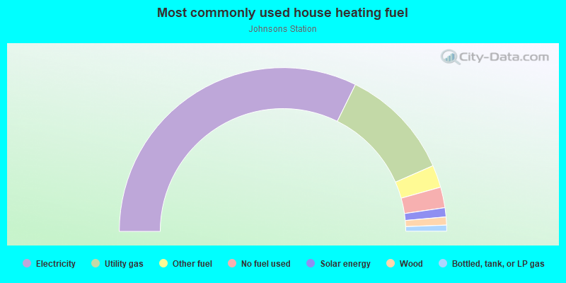
- 64.6%Electricity
- 22.3%Utility gas
- 4.4%Other fuel
- 4.1%No fuel used
- 1.8%Solar energy
- 1.6%Wood
- 1.2%Bottled, tank, or LP gas
Limited-access highways (interstate or state) in this neighborhood:
I- 20
Length: 3.73 miles
Direction: E-W
Direction: E-W
Roads and streets:
Matlock Rd
Length: 3.33 miles
Direction: N-S
Address range: 2800 to 4499
Direction: N-S
Address range: 2800 to 4499
W Mayfield Rd
Length: 3.32 miles
Directions: E-W, SE-NW
Address range: 700 to 1904
Directions: E-W, SE-NW
Address range: 700 to 1904
Parks at Arlington Mall
Length: 2.51 miles
Directions: E-W, N-S, SE-NW, SW-NE
Directions: E-W, N-S, SE-NW, SW-NE
S Cooper St (FM 157)
Length: 2.02 miles
Directions: N-S, SE-NW, SW-NE
Address range: 2800 to 4399
Directions: N-S, SE-NW, SW-NE
Address range: 2800 to 4399
W Arbrook Blvd
Length: 2.01 miles
Directions: E-W, SE-NW, SW-NE
Address range: 676 to 2119
Directions: E-W, SE-NW, SW-NE
Address range: 676 to 2119
Arbrook Blvd
Length: 1.71 miles
Directions: E-W, SE-NW, SW-NE
Directions: E-W, SE-NW, SW-NE
Waverly Dr
Length: 1.32 miles
Directions: E-W, SE-NW, SW-NE
Address range: 700 to 3799
Directions: E-W, SE-NW, SW-NE
Address range: 700 to 3799
W Pleasant Ridge Rd
Length: 1.20 miles
Directions: E-W, SW-NE
Address range: 1700 to 2098
Directions: E-W, SW-NE
Address range: 1700 to 2098
California Ln
Length: 1.12 miles
Direction: E-W
Address range: 1100 to 1999
Direction: E-W
Address range: 1100 to 1999
S Fielder Rd
Length: 1.09 miles
Directions: N-S, SW-NE
Address range: 2800 to 3799
Directions: N-S, SW-NE
Address range: 2800 to 3799
High Point Rd
Length: 1.07 miles
Directions: E-W, SE-NW
Address range: 700 to 1299
Directions: E-W, SE-NW
Address range: 700 to 1299
Melear Dr
Length: 0.95 miles
Directions: N-S, SE-NW
Address range: 3200 to 4099
Directions: N-S, SE-NW
Address range: 3200 to 4099
Saddle Creek Cir
Length: 0.93 miles
Directions: E-W, N-S, SE-NW, SW-NE
Address range: 1600 to 1706
Directions: E-W, N-S, SE-NW, SW-NE
Address range: 1600 to 1706
Highlander Blvd
Length: 0.89 miles
Directions: E-W, SE-NW, SW-NE
Address range: 700 to 999
Directions: E-W, SE-NW, SW-NE
Address range: 700 to 999
Paisley Dr
Length: 0.82 miles
Directions: E-W, SW-NE
Address range: 1300 to 1938
Directions: E-W, SW-NE
Address range: 1300 to 1938
Glenbrook Dr
Length: 0.81 miles
Directions: E-W, N-S, SE-NW
Address range: 3600 to 4099
Directions: E-W, N-S, SE-NW
Address range: 3600 to 4099
Pleasant Valley Ln
Length: 0.69 miles
Directions: E-W, N-S, SE-NW, SW-NE
Address range: 1000 to 3499
Directions: E-W, N-S, SE-NW, SW-NE
Address range: 1000 to 3499
Blue Danube St
Length: 0.68 miles
Directions: E-W, N-S, SE-NW, SW-NE
Address range: 1300 to 1897
Directions: E-W, N-S, SE-NW, SW-NE
Address range: 1300 to 1897
Glasgow Dr
Length: 0.65 miles
Directions: E-W, N-S, SE-NW, SW-NE
Address range: 1618 to 3299
Directions: E-W, N-S, SE-NW, SW-NE
Address range: 1618 to 3299
Fox Hill Dr
Length: 0.53 miles
Directions: N-S, SE-NW, SW-NE
Address range: 2800 to 3299
Directions: N-S, SE-NW, SW-NE
Address range: 2800 to 3299
Cannongate Dr
Length: 0.52 miles
Directions: N-S, SE-NW
Address range: 2800 to 3299
Directions: N-S, SE-NW
Address range: 2800 to 3299
Swafford St
Length: 0.52 miles
Directions: N-S, SW-NE
Address range: 3400 to 3699
Directions: N-S, SW-NE
Address range: 3400 to 3699
Lynbrook Ln
Length: 0.49 miles
Directions: E-W, N-S, SE-NW
Address range: 1900 to 4099
Directions: E-W, N-S, SE-NW
Address range: 1900 to 4099
Medlin Dr
Length: 0.47 miles
Directions: N-S, SE-NW
Address range: 2800 to 3117
Directions: N-S, SE-NW
Address range: 2800 to 3117
S Hwy 157
Length: 0.43 miles
Direction: N-S
Direction: N-S
Ridgebrook Dr
Length: 0.43 miles
Directions: E-W, SE-NW
Address range: 1800 to 4099
Directions: E-W, SE-NW
Address range: 1800 to 4099
Leighton Dr
Length: 0.43 miles
Directions: E-W, N-S, SW-NE
Address range: 1902 to 3699
Directions: E-W, N-S, SW-NE
Address range: 1902 to 3699
Alexandria Dr
Length: 0.38 miles
Directions: N-S, SW-NE
Address range: 3500 to 3799
Directions: N-S, SW-NE
Address range: 3500 to 3799
Winslow Dr
Length: 0.36 miles
Directions: N-S, SW-NE
Address range: 3500 to 3699
Directions: N-S, SW-NE
Address range: 3500 to 3699
Ashbury Dr
Length: 0.30 miles
Directions: E-W, N-S, SE-NW
Address range: 2700 to 2999
Directions: E-W, N-S, SE-NW
Address range: 2700 to 2999
Scots Legacy Dr
Length: 0.30 miles
Direction: N-S
Address range: 3900 to 4099
Direction: N-S
Address range: 3900 to 4099
Inniswood Cir
Length: 0.27 miles
Directions: E-W, N-S, SE-NW, SW-NE
Address range: 2800 to 2899
Directions: E-W, N-S, SE-NW, SW-NE
Address range: 2800 to 2899
Pleasant Pl
Length: 0.27 miles
Directions: E-W, SE-NW
Address range: 1700 to 1899
Directions: E-W, SE-NW
Address range: 1700 to 1899
Hoya Dr
Length: 0.26 miles
Directions: E-W, N-S, SE-NW, SW-NE
Address range: 3600 to 3699
Directions: E-W, N-S, SE-NW, SW-NE
Address range: 3600 to 3699
Queensborough Dr
Length: 0.25 miles
Direction: E-W
Address range: 1700 to 1899
Direction: E-W
Address range: 1700 to 1899
Barnett Blvd
Length: 0.25 miles
Direction: N-S
Address range: 4200 to 4499
Direction: N-S
Address range: 4200 to 4499
Larry Ln
Length: 0.25 miles
Direction: N-S
Address range: 4200 to 4499
Direction: N-S
Address range: 4200 to 4499
Kathey Dr
Length: 0.25 miles
Directions: N-S, SE-NW
Address range: 4200 to 4499
Directions: N-S, SE-NW
Address range: 4200 to 4499
Longmeadow Dr
Length: 0.25 miles
Directions: E-W, N-S, SE-NW, SW-NE
Address range: 1900 to 3899
Directions: E-W, N-S, SE-NW, SW-NE
Address range: 1900 to 3899
Treetop Trl
Length: 0.24 miles
Directions: E-W, N-S, SE-NW, SW-NE
Address range: 100 to 299
Directions: E-W, N-S, SE-NW, SW-NE
Address range: 100 to 299
Kingsborough Dr
Length: 0.24 miles
Direction: E-W
Address range: 1700 to 1899
Direction: E-W
Address range: 1700 to 1899
Willowood Cir
Length: 0.23 miles
Directions: E-W, N-S, SE-NW, SW-NE
Address range: 3400 to 3599
Directions: E-W, N-S, SE-NW, SW-NE
Address range: 3400 to 3599
Carlton Dr
Length: 0.22 miles
Direction: E-W
Address range: 1700 to 1899
Direction: E-W
Address range: 1700 to 1899
Dickens Ct
Length: 0.21 miles
Directions: E-W, SE-NW
Address range: 1100 to 1299
Directions: E-W, SE-NW
Address range: 1100 to 1299
Fiji Dr
Length: 0.21 miles
Directions: E-W, N-S
Address range: 1800 to 1899
Directions: E-W, N-S
Address range: 1800 to 1899
Knight St
Length: 0.21 miles
Directions: E-W, SE-NW
Address range: 1300 to 1399
Directions: E-W, SE-NW
Address range: 1300 to 1399
Grammercy Park Dr
Length: 0.21 miles
Directions: E-W, N-S, SE-NW, SW-NE
Address range: 3700 to 3799
Directions: E-W, N-S, SE-NW, SW-NE
Address range: 3700 to 3799
Avonhill Dr
Length: 0.21 miles
Directions: N-S, SE-NW
Address range: 2711 to 2999
Directions: N-S, SE-NW
Address range: 2711 to 2999
Martindale Dr
Length: 0.21 miles
Direction: N-S
Address range: 4300 to 4399
Direction: N-S
Address range: 4300 to 4399
W Stephens St
Length: 0.20 miles
Direction: E-W
Address range: 700 to 899
Direction: E-W
Address range: 700 to 899
Georgetown St
Length: 0.20 miles
Directions: E-W, SW-NE
Address range: 1100 to 3799
Directions: E-W, SW-NE
Address range: 1100 to 3799
Rolling Meadows Dr
Length: 0.19 miles
Directions: E-W, SW-NE
Address range: 800 to 999
Directions: E-W, SW-NE
Address range: 800 to 999
Fielders Glen Dr
Length: 0.19 miles
Directions: E-W, N-S, SE-NW, SW-NE
Address range: 3500 to 3699
Directions: E-W, N-S, SE-NW, SW-NE
Address range: 3500 to 3699
Woodway Dr
Length: 0.19 miles
Direction: E-W
Address range: 2000 to 2199
Direction: E-W
Address range: 2000 to 2199
Dartmouth Ct
Length: 0.18 miles
Directions: E-W, N-S, SW-NE
Address range: 1900 to 2099
Directions: E-W, N-S, SW-NE
Address range: 1900 to 2099
Wakefield Dr
Length: 0.18 miles
Directions: E-W, SE-NW
Address range: 1200 to 1299
Directions: E-W, SE-NW
Address range: 1200 to 1299
Royal Mile Dr
Length: 0.18 miles
Directions: E-W, SW-NE
Address range: 1600 to 1799
Directions: E-W, SW-NE
Address range: 1600 to 1799
Riverhead Dr
Length: 0.16 miles
Directions: E-W, N-S, SE-NW, SW-NE
Address range: 3600 to 3699
Directions: E-W, N-S, SE-NW, SW-NE
Address range: 3600 to 3699
Devonshire Dr
Length: 0.16 miles
Directions: E-W, SE-NW
Address range: 1900 to 1999
Directions: E-W, SE-NW
Address range: 1900 to 1999
Plover Ln
Length: 0.16 miles
Direction: E-W
Address range: 1000 to 1099
Direction: E-W
Address range: 1000 to 1099
Point Trl
Length: 0.16 miles
Direction: E-W
Address range: 300 to 1999
Direction: E-W
Address range: 300 to 1999
Hudson Dr
Length: 0.16 miles
Directions: E-W, N-S, SE-NW, SW-NE
Address range: 3500 to 3599
Directions: E-W, N-S, SE-NW, SW-NE
Address range: 3500 to 3599
Penbrook Dr
Length: 0.15 miles
Directions: E-W, SE-NW
Address range: 1900 to 1999
Directions: E-W, SE-NW
Address range: 1900 to 1999
Timbersedge Trl
Length: 0.15 miles
Directions: N-S, SE-NW
Address range: 4100 to 4199
Directions: N-S, SE-NW
Address range: 4100 to 4199
Wingrove Dr
Length: 0.15 miles
Direction: N-S
Address range: 4200 to 4299
Direction: N-S
Address range: 4200 to 4299
Meadow Way Cir S
Length: 0.14 miles
Directions: E-W, SE-NW, SW-NE
Address range: 2000 to 2099
Directions: E-W, SE-NW, SW-NE
Address range: 2000 to 2099
Sexton Dr
Length: 0.14 miles
Direction: E-W
Address range: 1900 to 2192
Direction: E-W
Address range: 1900 to 2192
Cape Hatteras Ln
Length: 0.14 miles
Directions: E-W, N-S
Address range: 3701 to 3799
Directions: E-W, N-S
Address range: 3701 to 3799
Providence Ct
Length: 0.14 miles
Direction: E-W
Address range: 1100 to 1199
Direction: E-W
Address range: 1100 to 1199
Burgess Ct
Length: 0.14 miles
Directions: E-W, SE-NW
Address range: 1100 to 1199
Directions: E-W, SE-NW
Address range: 1100 to 1199
Laurel Hill Ct
Length: 0.14 miles
Direction: E-W
Address range: 1100 to 1199
Direction: E-W
Address range: 1100 to 1199
Cory Lee Ct
Length: 0.14 miles
Direction: N-S
Address range: 4100 to 4199
Direction: N-S
Address range: 4100 to 4199
Meadow Way Cir N
Length: 0.14 miles
Directions: E-W, N-S, SE-NW, SW-NE
Address range: 2000 to 2099
Directions: E-W, N-S, SE-NW, SW-NE
Address range: 2000 to 2099
N Hunters Glen Cir
Length: 0.14 miles
Directions: E-W, N-S, SE-NW
Address range: 700 to 3699
Directions: E-W, N-S, SE-NW
Address range: 700 to 3699
Ramos Dr
Length: 0.13 miles
Directions: E-W, SW-NE
Address range: 1600 to 3505
Directions: E-W, SW-NE
Address range: 1600 to 3505
Creek Walk Pl
Length: 0.13 miles
Directions: E-W, N-S, SE-NW
Address range: 700 to 799
Directions: E-W, N-S, SE-NW
Address range: 700 to 799
Westador Dr
Length: 0.12 miles
Directions: N-S, SE-NW, SW-NE
Address range: 3100 to 3199
Directions: N-S, SE-NW, SW-NE
Address range: 3100 to 3199
Glen Field Ct
Length: 0.12 miles
Directions: E-W, N-S, SE-NW, SW-NE
Address range: 3549 to 3607
Directions: E-W, N-S, SE-NW, SW-NE
Address range: 3549 to 3607
Winnsboro Ct
Length: 0.12 miles
Direction: E-W
Address range: 1000 to 1099
Direction: E-W
Address range: 1000 to 1099
Merrywood Dr
Length: 0.12 miles
Direction: N-S
Address range: 3400 to 3499
Direction: N-S
Address range: 3400 to 3499
Fairfax Ct
Length: 0.12 miles
Directions: E-W, SE-NW
Address range: 1000 to 1099
Directions: E-W, SE-NW
Address range: 1000 to 1099
Avington Ct
Length: 0.12 miles
Direction: E-W
Address range: 1000 to 1099
Direction: E-W
Address range: 1000 to 1099
Deerfield Cir S
Length: 0.11 miles
Directions: E-W, SW-NE
Address range: 712 to 3625
Directions: E-W, SW-NE
Address range: 712 to 3625
Kircaldy Ct
Length: 0.11 miles
Directions: E-W, N-S, SW-NE
Address range: 2900 to 2999
Directions: E-W, N-S, SW-NE
Address range: 2900 to 2999
Cristopher Ct
Length: 0.11 miles
Direction: E-W
Address range: 1000 to 1099
Direction: E-W
Address range: 1000 to 1099
Timberwood Cir
Length: 0.11 miles
Direction: N-S
Address range: 3400 to 3599
Direction: N-S
Address range: 3400 to 3599
Westador Dr S
Length: 0.11 miles
Directions: E-W, SE-NW
Address range: 1300 to 1399
Directions: E-W, SE-NW
Address range: 1300 to 1399
Westador Dr N
Length: 0.11 miles
Direction: E-W
Address range: 1300 to 3119
Direction: E-W
Address range: 1300 to 3119
Rall Ct
Length: 0.11 miles
Directions: N-S, SW-NE
Address range: 3400 to 3898
Directions: N-S, SW-NE
Address range: 3400 to 3898
S Hunters Glen Cir
Length: 0.11 miles
Direction: E-W
Address range: 700 to 799
Direction: E-W
Address range: 700 to 799
Melville Dr
Length: 0.11 miles
Directions: E-W, SE-NW
Address range: 800 to 899
Directions: E-W, SE-NW
Address range: 800 to 899
Mosswood Ct
Length: 0.11 miles
Directions: E-W, SW-NE
Address range: 2000 to 2099
Directions: E-W, SW-NE
Address range: 2000 to 2099
Torch Dr
Length: 0.10 miles
Directions: E-W, SE-NW
Address range: 1700 to 1799
Directions: E-W, SE-NW
Address range: 1700 to 1799
Deerfield Cir N
Length: 0.10 miles
Directions: E-W, SE-NW
Address range: 713 to 732
Directions: E-W, SE-NW
Address range: 713 to 732
Wakefield Cir
Length: 0.10 miles
Direction: SW-NE
Address range: 3500 to 3599
Direction: SW-NE
Address range: 3500 to 3599
Advent St
Length: 0.10 miles
Directions: E-W, N-S, SW-NE
Directions: E-W, N-S, SW-NE
Sugar Plum Ln
Length: 0.10 miles
Directions: E-W, N-S, SW-NE
Address range: 3400 to 3499
Directions: E-W, N-S, SW-NE
Address range: 3400 to 3499
Hermitage Pl
Length: 0.10 miles
Directions: E-W, SW-NE
Address range: 1100 to 1199
Directions: E-W, SW-NE
Address range: 1100 to 1199
Edgebrook Ct
Length: 0.10 miles
Directions: E-W, SW-NE
Address range: 2000 to 2099
Directions: E-W, SW-NE
Address range: 2000 to 2099
Stephens St W
Length: 0.10 miles
Direction: E-W
Address range: 810 to 817
Direction: E-W
Address range: 810 to 817
Westminster Ct
Length: 0.09 miles
Direction: E-W
Address range: 1000 to 1099
Direction: E-W
Address range: 1000 to 1099
Stephens Dr
Length: 0.09 miles
Direction: E-W
Address range: 900 to 999
Direction: E-W
Address range: 900 to 999
Berkeley Ln
Length: 0.09 miles
Direction: E-W
Address range: 1400 to 1499
Direction: E-W
Address range: 1400 to 1499
Kelham Ct
Length: 0.09 miles
Directions: E-W, SW-NE
Address range: 3000 to 3099
Directions: E-W, SW-NE
Address range: 3000 to 3099
Campeche Dr
Length: 0.09 miles
Direction: E-W
Direction: E-W
Headwater Dr
Length: 0.09 miles
Direction: E-W
Address range: 800 to 899
Direction: E-W
Address range: 800 to 899
Llano Trl
Length: 0.09 miles
Directions: E-W, N-S, SE-NW
Address range: 3500 to 3599
Directions: E-W, N-S, SE-NW
Address range: 3500 to 3599
Swan Ct
Length: 0.09 miles
Directions: E-W, SE-NW, SW-NE
Address range: 3400 to 3499
Directions: E-W, SE-NW, SW-NE
Address range: 3400 to 3499
Largo Ln
Length: 0.08 miles
Direction: N-S
Address range: 3400 to 3499
Direction: N-S
Address range: 3400 to 3499
Duther Dr
Length: 0.08 miles
Direction: N-S
Address range: 2701 to 2799
Direction: N-S
Address range: 2701 to 2799
Capri Ln
Length: 0.08 miles
Direction: N-S
Address range: 3400 to 3499
Direction: N-S
Address range: 3400 to 3499
Parks Mall Dr
Length: 0.08 miles
Directions: E-W, N-S, SW-NE
Address range: 3900 to 3999
Directions: E-W, N-S, SW-NE
Address range: 3900 to 3999
Stratford Ct
Length: 0.08 miles
Direction: N-S
Address range: 2900 to 2999
Direction: N-S
Address range: 2900 to 2999
Pitcarin Ln
Length: 0.08 miles
Direction: E-W
Address range: 1800 to 1899
Direction: E-W
Address range: 1800 to 1899
Hyde Park Ln
Length: 0.08 miles
Direction: E-W
Address range: 1400 to 1499
Direction: E-W
Address range: 1400 to 1499
Fox Hill Ct
Length: 0.08 miles
Direction: E-W
Address range: 1900 to 1999
Direction: E-W
Address range: 1900 to 1999
Forestgate Cir
Length: 0.08 miles
Directions: E-W, N-S, SE-NW, SW-NE
Directions: E-W, N-S, SE-NW, SW-NE
Waverly Ct
Length: 0.07 miles
Directions: N-S, SW-NE
Address range: 3500 to 3599
Directions: N-S, SW-NE
Address range: 3500 to 3599
Maxwell Ct
Length: 0.07 miles
Direction: N-S
Address range: 3700 to 3799
Direction: N-S
Address range: 3700 to 3799
Windsor Place Ct
Length: 0.07 miles
Directions: E-W, N-S, SE-NW
Address range: 1900 to 1999
Directions: E-W, N-S, SE-NW
Address range: 1900 to 1999
Park Grove Ct
Length: 0.07 miles
Direction: E-W
Address range: 1900 to 1999
Direction: E-W
Address range: 1900 to 1999
Saltillo Ln
Length: 0.07 miles
Direction: SW-NE
Address range: 3400 to 3505
Direction: SW-NE
Address range: 3400 to 3505
Claysford Ct
Length: 0.07 miles
Direction: N-S
Address range: 3700 to 3799
Direction: N-S
Address range: 3700 to 3799
Lindsey Ct
Length: 0.07 miles
Direction: N-S
Address range: 3700 to 3799
Direction: N-S
Address range: 3700 to 3799
Southseas Ln
Length: 0.07 miles
Direction: E-W
Address range: 1800 to 1899
Direction: E-W
Address range: 1800 to 1899
Marble Arch Ln
Length: 0.07 miles
Directions: N-S, SE-NW
Address range: 3201 to 3220
Directions: N-S, SE-NW
Address range: 3201 to 3220
Leather Leaf Ln
Length: 0.07 miles
Directions: E-W, N-S, SE-NW
Address range: 3400 to 3499
Directions: E-W, N-S, SE-NW
Address range: 3400 to 3499
Scotswood Dr
Length: 0.06 miles
Direction: E-W
Address range: 1500 to 1512
Direction: E-W
Address range: 1500 to 1512
Hunters Glen Cir
Length: 0.06 miles
Directions: N-S, SW-NE
Address range: 700 to 3667
Directions: N-S, SW-NE
Address range: 700 to 3667
Westador Ct
Length: 0.06 miles
Direction: N-S
Address range: 3100 to 3199
Direction: N-S
Address range: 3100 to 3199
Hollypoint Ct
Length: 0.06 miles
Direction: N-S
Address range: 2800 to 2820
Direction: N-S
Address range: 2800 to 2820
Windsor Wood Dr
Length: 0.06 miles
Directions: E-W, N-S, SE-NW, SW-NE
Address range: 3200 to 3299
Directions: E-W, N-S, SE-NW, SW-NE
Address range: 3200 to 3299
Ashbury Ct
Length: 0.06 miles
Direction: E-W
Address range: 1300 to 1399
Direction: E-W
Address range: 1300 to 1399
Clark Ct
Length: 0.06 miles
Directions: N-S, SW-NE
Address range: 3700 to 3799
Directions: N-S, SW-NE
Address range: 3700 to 3799
Founders Trl
Length: 0.05 miles
Direction: SW-NE
Address range: 3400 to 3499
Direction: SW-NE
Address range: 3400 to 3499
Deerfield Cir
Length: 0.05 miles
Directions: N-S, SE-NW, SW-NE
Address range: 3600 to 3699
Directions: N-S, SE-NW, SW-NE
Address range: 3600 to 3699
Winslow Ct
Length: 0.05 miles
Direction: N-S
Address range: 3700 to 3799
Direction: N-S
Address range: 3700 to 3799
Forestgate Dr
Length: 0.05 miles
Directions: N-S, SE-NW
Address range: 4500 to 4598
Directions: N-S, SE-NW
Address range: 4500 to 4598
Scotsview Ct
Length: 0.05 miles
Direction: N-S
Address range: 3500 to 3599
Direction: N-S
Address range: 3500 to 3599
Wakefield Ct
Length: 0.04 miles
Direction: SW-NE
Address range: 3500 to 3599
Direction: SW-NE
Address range: 3500 to 3599
Glasgow Ct
Length: 0.04 miles
Direction: SE-NW
Address range: 3000 to 3099
Direction: SE-NW
Address range: 3000 to 3099
Hollyridge Ct
Length: 0.04 miles
Directions: N-S, SW-NE
Address range: 3700 to 3799
Directions: N-S, SW-NE
Address range: 3700 to 3799
Hyde Park Ct
Length: 0.04 miles
Direction: N-S
Address range: 3200 to 3299
Direction: N-S
Address range: 3200 to 3299
Glenfield Ct
Length: 0.04 miles
Direction: E-W
Address range: 3549 to 3561
Direction: E-W
Address range: 3549 to 3561
Newport Ct
Length: 0.04 miles
Direction: N-S
Address range: 3100 to 3199
Direction: N-S
Address range: 3100 to 3199
Glasgow Ter
Length: 0.03 miles
Direction: E-W
Address range: 3200 to 3299
Direction: E-W
Address range: 3200 to 3299
Claireisa Ct
Length: 0.03 miles
Direction: N-S
Address range: 2700 to 2716
Direction: N-S
Address range: 2700 to 2716
Fulton Ct
Length: 0.03 miles
Direction: N-S
Address range: 3400 to 3499
Direction: N-S
Address range: 3400 to 3499
Dickens Cir
Length: 0.03 miles
Direction: SW-NE
Address range: 3500 to 3599
Direction: SW-NE
Address range: 3500 to 3599
Apaloosa Trl
Length: 0.03 miles
Direction: E-W
Direction: E-W
Allison Ct
Length: 0.03 miles
Direction: N-S
Address range: 3400 to 3499
Direction: N-S
Address range: 3400 to 3499
Skipper Ct
Length: 0.03 miles
Direction: E-W
Address range: 1700 to 1799
Direction: E-W
Address range: 1700 to 1799
Glen Creek Ct
Length: 0.03 miles
Directions: E-W, SW-NE
Address range: 2000 to 2099
Directions: E-W, SW-NE
Address range: 2000 to 2099
Royal Mile Ct
Length: 0.02 miles
Direction: SE-NW
Address range: 1600 to 1699
Direction: SE-NW
Address range: 1600 to 1699
Windhurst Dr
Length: 0.02 miles
Direction: E-W
Direction: E-W
Glen Rapids Ct
Length: 0.02 miles
Direction: E-W
Address range: 2000 to 2099
Direction: E-W
Address range: 2000 to 2099
Other features:
Turtle Crk
Length: 0.03 miles
Directions: E-W, SW-NE
Directions: E-W, SW-NE