Kenwood Park neighborhood in Oak Park, Michigan (MI), 48075, 48237 detailed profile
Settings
X


Business Search - 14 Million verified businesses
Area: 4.082 square miles
Population: 21,040
Population density:
| Kenwood Park: | 5,155 people per square mile |
| Oak Park: | 5,873 people per square mile |

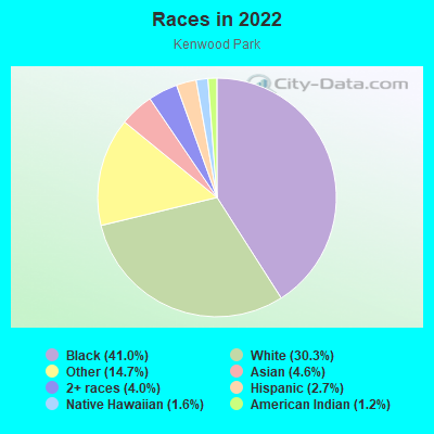
- 11,04441.0%Black
- 8,15330.3%White
- 3,94914.7%Some other race
- 1,2374.6%Asian
- 1,0744.0%Two or more races
- 7342.7%Hispanic or Latino
- 4241.6%Native Hawaiian and Other
Pacific Islander - 3341.2%American Indian
Distribution of median household income
![Distribution of median household income]()
- 505Less than $10,000
- 1,284$10,000 to $19,999
- 1,333$20,000 to $29,999
- 853$30,000 to $39,999
- 1,467$40,000 to $49,999
- 1,157$50,000 to $59,999
- 796$60,000 to $74,999
- 1,265$75,000 to $99,999
- 904$100,000 to $124,999
- 1,017$125,000 to $149,999
- 678$150,000 to $199,999
- 584$200,000 or more

Distribution of owner-occupied house/condo value
![Distribution of owner-occupied house/condo value]()
- 3,371Less than $50,000
- 4,112$50,000 to $99,999
- 1,719$100,000 to $149,999
- 1,409$150,000 to $199,999
- 1,219$200,000 to $249,999
- 908$250,000 to $299,999
- 1,135$300,000 to $399,999
- 1,512$400,000 to $499,999
- 1,014$500,000 to $749,999
- 141$750,000 to $999,999
- 238$1,000,000 or more

Distribution of rent paid by renters
![Distribution of rent paid by renters]()
- 128Less than $100
- 2,789$200 to $299
- 512$300 to $399
- 2,500$400 to $499
- 485$500 to $599
- 923$600 to $699
- 1,403$700 to $799
- 902$800 to $899
- 608$900 to $999
- 1,383$1,000 to $1,249
- 721$1,250 to $1,499
- 775$1,500 to $1,999
- 684$2,000 or more

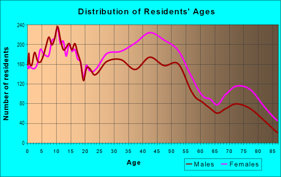
| Males: | 9,615 |
| Females: | 11,425 |
Males:
| This neighborhood: | |
| Whole city: |
| This neighborhood: | |
| Whole city: |
Average household size:
| Kenwood Park: | 4.5 people |
| Oak Park: | 2.4 people |
Percentage of family households:
| Kenwood Park: | 43.8% |
| Oak Park: | 42.4% |
| Here: | 38.6% |
| Oak Park: | 32.7% |
Percentage of married-couple families with children (among all households):
| Kenwood Park: | 29.9% |
| Oak Park: | 25.8% |
Percentage of single-mother households (among all households):
| Kenwood Park: | 14.9% |
| Oak Park: | 13.7% |
Percentage of never married males 15 years old and over:
Percentage of never married females 15 years old and over:
| Kenwood Park: | 18.0% |
| Oak Park: | 21.3% |
Percentage of never married females 15 years old and over:
| Kenwood Park: | 20.3% |
| city: | 21.2% |
Percentage of people that speak English not well or not at all:
| Kenwood Park: | 2.8% |
| Oak Park: | 3.0% |
Percentage of people born in this state:
Percentage of people born in another U.S. state:
Percentage of native residents but born outside the U.S.:
Percentage of foreign born residents:
| Here: | 70.7% |
| Oak Park: | 71.7% |
Percentage of people born in another U.S. state:
| Kenwood Park: | 17.2% |
| Oak Park: | 16.0% |
Percentage of native residents but born outside the U.S.:
| Here: | 3.7% |
| city: | 2.8% |
Percentage of foreign born residents:
| Here: | 8.8% |
| Oak Park: | 9.4% |
Owner-occupied
Renter-occupied

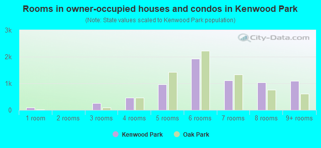
- Rooms in owner-occupied houses and condos in Kenwood Park
- 881 room
- 02 rooms
- 2593 rooms
- 4684 rooms
- 9665 rooms
- 1,9176 rooms
- 1,1057 rooms
- 1,0378 rooms
- 1,0979+ rooms
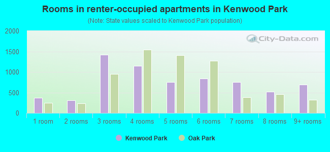
- Rooms in renter-occupied apartments in Kenwood Park
- 3751 room
- 3132 rooms
- 1,4143 rooms
- 1,1534 rooms
- 7525 rooms
- 8376 rooms
- 7477 rooms
- 5208 rooms
- 6979+ rooms
Owner-occupied
Renter-occupied
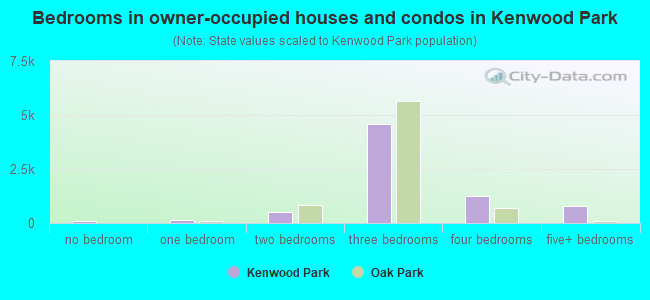
- Bedrooms in owner-occupied houses and condos in Kenwood Park
- 88no bedroom
- 1591 bedroom
- 5102 bedrooms
- 4,5953 bedrooms
- 1,2384 bedrooms
- 7925+ bedrooms
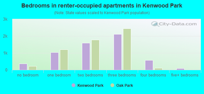
- Bedrooms in renter-occupied apartments in Kenwood Park
- 375no bedroom
- 1,0301 bedroom
- 1,5982 bedrooms
- 2,1153 bedrooms
- 5694 bedrooms
- 1005+ bedrooms
Average number of cars or other vehicles available in houses/condos:
Average number of cars or other vehicles available in apartments:
| This neighborhood: | |
| Oak Park: |
Average number of cars or other vehicles available in apartments:
| Here: | |
| city: |
Percentage of units with a mortgage:
| Kenwood Park: | 66.4% |
| Oak Park: | 68.4% |
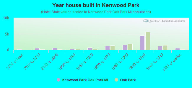
- Year house built in Kenwood Park
- 1672020 or later
- 5442010 to 2019
- 5982000 to 2009
- 3231990 to 1999
- 7791980 to 1989
- 1,2391970 to 1979
- 1,5981960 to 1969
- 4,5141950 to 1959
- 1,2121940 to 1949
- 5541939 or earlier
City-data.com crime index for city in 2020 (higher means more crime):
| City: | 191.8 |
| U.S. average: | 219.5 |
Travel time to work (commute)
![Travel time to work (commute)]()
- 240Less than 5 minutes
- 8195 to 9 minutes
- 1,21910 to 14 minutes
- 1,02215 to 19 minutes
- 1,39420 to 24 minutes
- 58825 to 29 minutes
- 96630 to 34 minutes
- 47035 to 39 minutes
- 17740 to 44 minutes
- 51645 to 59 minutes
- 20560 to 89 minutes
- 5890 or more minutes

Means of transportation to work
![Means of transportation to work]()
- 67.5%6,422Drove a car alone
- 11.3%1,072Carpooled
- 1.7%162Bus
- 3.3%313Ferryboat
- 13.6%1,292Taxi
- 1.4%136Bicycle
- 2.8%265Walked
- 2.4%226Other means
- 24.8%2,360Worked at home

Time leaving home to go to work
![Time leaving home to go to work]()
- 17712:00 a.m. to 4:59 a.m.
- 2095:00 a.m. to 5:29 a.m.
- 1965:30 a.m. to 5:59 a.m.
- 4586:00 a.m. to 6:29 a.m.
- 5136:30 a.m. to 6:59 a.m.
- 9067:00 a.m. to 7:29 a.m.
- 6087:30 a.m. to 7:59 a.m.
- 7968:00 a.m. to 8:29 a.m.
- 6218:30 a.m. to 8:59 a.m.
- 8949:00 a.m. to 9:59 a.m.
- 56110:00 a.m. to 10:59 a.m.
- 14111:00 a.m. to 11:59 a.m.
- 72312:00 p.m. to 3:59 p.m.
- 5714:00 p.m. to 11:59 p.m.

Occupations of males:
- Percentage of males in management occupations (except farmers):
Here: 8.9% city: 11.4%
- Percentage of males in business and financial operations occupations:
Here: 6.7% city: 5.2%
- Percentage of males in computer and mathematical occupations:
Here: 7.9% city: 8.0%
- Percentage of males in architecture and engineering occupations:
Here: 4.5% city: 3.3%
- Percentage of males in life, physical, and social science occupations:
Here: 2.7% city: 1.6%
- Percentage of males in community and social services occupations:
Here: 1.2% city: 0.4%
- Percentage of males in legal occupations:
Here: 3.1% city: 2.4%
- Percentage of males in education, training, and library occupations:
Here: 2.4% city: 3.2%
- Percentage of males in arts, design, entertainment, sports, and media occupations:
Here: 4.9% city: 4.0%
- Percentage of males in healthcare practitioners and technical occupations:
Here: 4.4% city: 2.9%
- Percentage of males in service occupations:
Here: 11.5% city: 11.0%
- Percentage of males in sales and office occupations:
Here: 16.4% city: 15.9%
- Percentage of males in farming, fishing, and forestry occupations:
Here: 1.8% city: 0.9%
- Percentage of males in construction, extraction, and maintenance occupations:
Here: 2.1% city: 4.0%
- Percentage of males in production occupations:
Here: 9.0% city: 10.2%
- Percentage of males in transportation occupations:
Here: 6.1% city: 8.2%
- Percentage of males in material moving occupations:
Here: 4.6% city: 4.6%
Occupations of females:
- Percentage of females in management occupations (except farmers):
Here: 11.2% city: 11.6%
- Percentage of females in business and financial operations occupations:
Here: 7.8% city: 8.5%
- Percentage of females in computer and mathematical occupations:
Here: 1.4% city: 2.5%
- Percentage of females in architecture and engineering occupations:
Here: 1.8% city: 2.0%
- Percentage of females in life, physical, and social science occupations:
Here: 1.3% city: 1.0%
- Percentage of females in community and social services occupations:
Here: 3.0% city: 4.6%
- Percentage of females in legal occupations:
Here: 1.4% city: 1.0%
- Percentage of females in education, training, and library occupations:
Here: 9.4% city: 9.1%
- Percentage of females in arts, design, entertainment, sports, and media occupations:
Here: 1.1% city: 2.0%
- Percentage of females in healthcare practitioners and technical occupations:
Here: 7.2% city: 6.0%
- Percentage of females in service occupations:
Here: 15.8% city: 16.2%
- Percentage of females in sales and office occupations:
Here: 34.8% city: 29.5%
- Percentage of females in production occupations:
Here: 2.1% city: 2.7%
Percentage of people 16-64 in Armed Forces:
| Kenwood Park: | 0.2% |
| Oak Park: | 0.2% |
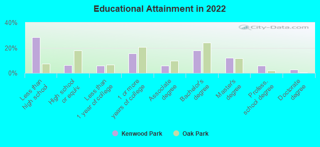
Education in this neighborhood (subdivision or community):
- Percentage of people 3 years and older in K-12 schools:
Kenwood Park: 28.4% Oak Park: 15.6%
- Percentage of people 3 years and older in undergraduate colleges:
Kenwood Park: 8.3% Oak Park: 4.4%
- Percentage of people 3 years and older in grad. or professional schools:
Kenwood Park: 4.5% Oak Park: 1.4%
- Percentage of students K-12 enrolled in private schools:
Kenwood Park: 102.1% Oak Park: 19.6%
Percentage of population below poverty level:
| Kenwood Park: | 16.2% |
| Oak Park: | 14.5% |
Percentage of married-couple families with both working:
| Kenwood Park: | 140.2% |
| Oak Park: | 78.0% |
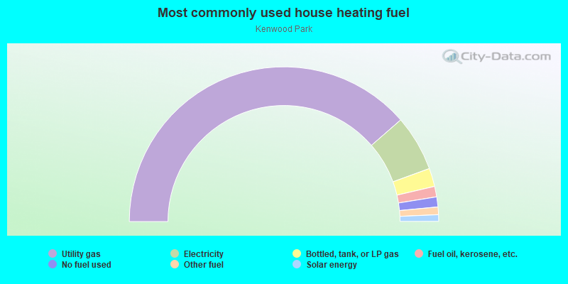
- 77.2%Utility gas
- 11.7%Electricity
- 3.8%Bottled, tank, or LP gas
- 2.2%Fuel oil, kerosene, etc.
- 2.1%No fuel used
- 1.6%Other fuel
- 1.4%Solar energy
Limited-access highways (interstate or state) in this neighborhood:
I- 696
Length: 3.14 miles
Directions: E-W, SE-NW
Directions: E-W, SE-NW
Highways in this neighborhood:
State Hwy 102 (W 8 Mile Rd)
Length: 1.68 miles
Direction: E-W
Address range: 12772 to 15538
Direction: E-W
Address range: 12772 to 15538
Roads and streets:
Coolidge Hwy
Length: 3.11 miles
Direction: N-S
Address range: 1700 to 26898
Direction: N-S
Address range: 1700 to 26898
Greenfield Rd
Length: 3.00 miles
Direction: N-S
Address range: 20700 to 26999
Direction: N-S
Address range: 20700 to 26999
Gardner St
Length: 2.31 miles
Directions: E-W, N-S, SE-NW
Address range: 20800 to 26999
Directions: E-W, N-S, SE-NW
Address range: 20800 to 26999
Kipling St
Length: 2.22 miles
Directions: N-S, SW-NE
Address range: 20700 to 26999
Directions: N-S, SW-NE
Address range: 20700 to 26999
Church St
Length: 1.84 miles
Directions: E-W, N-S, SE-NW
Address range: 21600 to 25399
Directions: E-W, N-S, SE-NW
Address range: 21600 to 25399
Marlow St
Length: 1.61 miles
Directions: E-W, N-S, SE-NW, SW-NE
Address range: 14512 to 24199
Directions: E-W, N-S, SE-NW, SW-NE
Address range: 14512 to 24199
Kenosha St
Length: 1.60 miles
Directions: E-W, N-S, SE-NW, SW-NE
Address range: 20800 to 25099
Directions: E-W, N-S, SE-NW, SW-NE
Address range: 20800 to 25099
W 9 Mile Rd
Length: 1.59 miles
Direction: E-W
Address range: 13300 to 15747
Direction: E-W
Address range: 13300 to 15747
W 11 Mile Rd (11 Mile Rd)
Length: 1.48 miles
Direction: E-W
Address range: 2300 to 15499
Direction: E-W
Address range: 2300 to 15499
Parklawn St
Length: 1.48 miles
Directions: N-S, SW-NE
Address range: 20800 to 24999
Directions: N-S, SW-NE
Address range: 20800 to 24999
Harding St
Length: 1.46 miles
Directions: E-W, N-S, SE-NW, SW-NE
Address range: 21800 to 26999
Directions: E-W, N-S, SE-NW, SW-NE
Address range: 21800 to 26999
W 10 Mile Rd
Length: 1.45 miles
Direction: E-W
Address range: 13426 to 15499
Direction: E-W
Address range: 13426 to 15499
Westhampton St
Length: 1.40 miles
Directions: N-S, SE-NW
Address range: 20700 to 24999
Directions: N-S, SE-NW
Address range: 20700 to 24999
Ridgedale St
Length: 1.37 miles
Directions: N-S, SE-NW, SW-NE
Address range: 20700 to 24999
Directions: N-S, SE-NW, SW-NE
Address range: 20700 to 24999
Kenwood St
Length: 1.36 miles
Directions: E-W, SE-NW, SW-NE
Address range: 13326 to 15499
Directions: E-W, SE-NW, SW-NE
Address range: 13326 to 15499
Dartmouth St
Length: 1.33 miles
Directions: E-W, SE-NW
Address range: 13374 to 15299
Directions: E-W, SE-NW
Address range: 13374 to 15299
Lincoln St
Length: 1.32 miles
Direction: E-W
Address range: 13600 to 15481
Direction: E-W
Address range: 13600 to 15481
Oak Park Blvd
Length: 1.30 miles
Direction: E-W
Address range: 13600 to 15499
Direction: E-W
Address range: 13600 to 15499
Cloverlawn St
Length: 1.25 miles
Direction: N-S
Address range: 21600 to 24999
Direction: N-S
Address range: 21600 to 24999
Northfield Blvd
Length: 1.18 miles
Directions: E-W, N-S, SW-NE
Address range: 13400 to 15499
Directions: E-W, N-S, SW-NE
Address range: 13400 to 15499
Sussex St
Length: 1.13 miles
Directions: E-W, N-S, SE-NW, SW-NE
Address range: 21600 to 24899
Directions: E-W, N-S, SE-NW, SW-NE
Address range: 21600 to 24899
Talbot St
Length: 1.10 miles
Direction: E-W
Address range: 13600 to 15099
Direction: E-W
Address range: 13600 to 15099
Pearson St
Length: 1.09 miles
Directions: E-W, SE-NW
Address range: 13600 to 15299
Directions: E-W, SE-NW
Address range: 13600 to 15299
Granzon St
Length: 1.06 miles
Directions: E-W, SW-NE
Address range: 13400 to 15399
Directions: E-W, SW-NE
Address range: 13400 to 15399
Berkley Ave
Length: 1.05 miles
Directions: E-W, N-S
Address range: 15000 to 26099
Directions: E-W, N-S
Address range: 15000 to 26099
Northgate Blvd
Length: 1.03 miles
Directions: E-W, N-S, SE-NW, SW-NE
Address range: 15000 to 15499
Directions: E-W, N-S, SE-NW, SW-NE
Address range: 15000 to 15499
Borgman St
Length: 1.02 miles
Directions: E-W, SW-NE
Address range: 13600 to 14899
Directions: E-W, SW-NE
Address range: 13600 to 14899
Beverly St
Length: 0.89 miles
Directions: N-S, SE-NW, SW-NE
Address range: 21800 to 24299
Directions: N-S, SE-NW, SW-NE
Address range: 21800 to 24299
Radclift St
Length: 0.87 miles
Directions: N-S, SW-NE
Address range: 23000 to 24999
Directions: N-S, SW-NE
Address range: 23000 to 24999
Balfour Ave (Balfour St)
Length: 0.85 miles
Directions: E-W, N-S, SE-NW
Address range: 13600 to 14999
Directions: E-W, N-S, SE-NW
Address range: 13600 to 14999
Northend Ave
Length: 0.81 miles
Direction: E-W
Address range: 13600 to 14599
Direction: E-W
Address range: 13600 to 14599
Kingston St
Length: 0.80 miles
Direction: E-W
Address range: 13600 to 14799
Direction: E-W
Address range: 13600 to 14799
Labelle St
Length: 0.77 miles
Direction: E-W
Address range: 13600 to 14799
Direction: E-W
Address range: 13600 to 14799
W Tenmile Rd (Ten Mile Rd)
Length: 0.72 miles
Direction: E-W
Direction: E-W
Ludlow St
Length: 0.69 miles
Direction: E-W
Address range: 13600 to 14699
Direction: E-W
Address range: 13600 to 14699
Avon Rd
Length: 0.68 miles
Directions: N-S, SE-NW
Address range: 21800 to 23599
Directions: N-S, SE-NW
Address range: 21800 to 23599
Lincoln Ter
Length: 0.68 miles
Directions: E-W, N-S, SE-NW, SW-NE
Address range: 25400 to 25699
Directions: E-W, N-S, SE-NW, SW-NE
Address range: 25400 to 25699
Manhattan St
Length: 0.66 miles
Direction: E-W
Address range: 13600 to 14599
Direction: E-W
Address range: 13600 to 14599
Elgin St
Length: 0.65 miles
Direction: E-W
Address range: 13600 to 15199
Direction: E-W
Address range: 13600 to 15199
Vernon St
Length: 0.62 miles
Directions: E-W, SW-NE
Address range: 13600 to 14599
Directions: E-W, SW-NE
Address range: 13600 to 14599
Rosemary Blvd
Length: 0.61 miles
Direction: E-W
Address range: 14000 to 15499
Direction: E-W
Address range: 14000 to 15499
Stratford St
Length: 0.59 miles
Directions: E-W, N-S, SE-NW, SW-NE
Address range: 21400 to 24599
Directions: E-W, N-S, SE-NW, SW-NE
Address range: 21400 to 24599
Sherwood St
Length: 0.56 miles
Direction: E-W
Address range: 13600 to 14699
Direction: E-W
Address range: 13600 to 14699
Wildwood St
Length: 0.54 miles
Directions: N-S, SE-NW, SW-NE
Address range: 23000 to 23999
Directions: N-S, SE-NW, SW-NE
Address range: 23000 to 23999
Cloverdale St
Length: 0.51 miles
Directions: E-W, N-S, SW-NE
Address range: 13600 to 14199
Directions: E-W, N-S, SW-NE
Address range: 13600 to 14199
Leslie St
Length: 0.51 miles
Directions: E-W, SW-NE
Address range: 14500 to 15499
Directions: E-W, SW-NE
Address range: 14500 to 15499
Columbia Rd
Length: 0.50 miles
Direction: E-W
Address range: 2300 to 2999
Direction: E-W
Address range: 2300 to 2999
Nadine St
Length: 0.48 miles
Direction: E-W
Address range: 13600 to 14399
Direction: E-W
Address range: 13600 to 14399
Stratford Ct
Length: 0.48 miles
Directions: E-W, N-S, SE-NW
Address range: 15000 to 22999
Directions: E-W, N-S, SE-NW
Address range: 15000 to 22999
Hart St
Length: 0.48 miles
Direction: E-W
Address range: 13600 to 14399
Direction: E-W
Address range: 13600 to 14399
Winchester St
Length: 0.47 miles
Direction: E-W
Address range: 13600 to 14199
Direction: E-W
Address range: 13600 to 14199
Victoria St
Length: 0.46 miles
Directions: E-W, SE-NW
Address range: 13600 to 14199
Directions: E-W, SE-NW
Address range: 13600 to 14199
Raine St
Length: 0.45 miles
Directions: N-S, SW-NE
Address range: 25900 to 26999
Directions: N-S, SW-NE
Address range: 25900 to 26999
Blackstone St
Length: 0.42 miles
Direction: N-S
Address range: 21900 to 24399
Direction: N-S
Address range: 21900 to 24399
Whitmore St
Length: 0.41 miles
Directions: N-S, SE-NW
Address range: 21600 to 22199
Directions: N-S, SE-NW
Address range: 21600 to 22199
Wales St
Length: 0.40 miles
Directions: E-W, SE-NW
Address range: 13600 to 14399
Directions: E-W, SE-NW
Address range: 13600 to 14399
Park St
Length: 0.37 miles
Directions: E-W, SE-NW
Address range: 14400 to 15499
Directions: E-W, SE-NW
Address range: 14400 to 15499
Burton St
Length: 0.34 miles
Directions: E-W, SW-NE
Address range: 15000 to 15399
Directions: E-W, SW-NE
Address range: 15000 to 15399
Kenton St
Length: 0.33 miles
Directions: E-W, N-S, SW-NE
Address range: 15000 to 15299
Directions: E-W, N-S, SW-NE
Address range: 15000 to 15299
Northgate
Length: 0.33 miles
Directions: E-W, N-S, SE-NW
Directions: E-W, N-S, SE-NW
Miller St
Length: 0.33 miles
Direction: E-W
Address range: 15000 to 15499
Direction: E-W
Address range: 15000 to 15499
James St
Length: 0.33 miles
Direction: E-W
Address range: 15000 to 15499
Direction: E-W
Address range: 15000 to 15499
Dante Ave
Length: 0.31 miles
Direction: N-S
Address range: 23166 to 24599
Direction: N-S
Address range: 23166 to 24599
Foster Winter Dr
Length: 0.29 miles
Directions: E-W, N-S, SE-NW
Address range: 22301 to 22499
Directions: E-W, N-S, SE-NW
Address range: 22301 to 22499
Greenbriar St
Length: 0.29 miles
Directions: E-W, SE-NW, SW-NE
Address range: 13900 to 14299
Directions: E-W, SE-NW, SW-NE
Address range: 13900 to 14299
Tyler St
Length: 0.28 miles
Direction: N-S
Address range: 25900 to 26999
Direction: N-S
Address range: 25900 to 26999
Briar Dr
Length: 0.28 miles
Directions: N-S, SE-NW, SW-NE
Address range: 25400 to 25899
Directions: N-S, SE-NW, SW-NE
Address range: 25400 to 25899
Joan St
Length: 0.28 miles
Directions: E-W, N-S, SE-NW
Address range: 15200 to 15399
Directions: E-W, N-S, SE-NW
Address range: 15200 to 15399
Stratford Pl
Length: 0.28 miles
Direction: N-S
Address range: 25900 to 26299
Direction: N-S
Address range: 25900 to 26299
Mc Clain Dr
Length: 0.26 miles
Directions: E-W, N-S, SE-NW
Address range: 23000 to 23399
Directions: E-W, N-S, SE-NW
Address range: 23000 to 23399
Pasadena St
Length: 0.26 miles
Direction: E-W
Address range: 13600 to 14399
Direction: E-W
Address range: 13600 to 14399
Dante St
Length: 0.24 miles
Direction: N-S
Address range: 21900 to 24399
Direction: N-S
Address range: 21900 to 24399
Rue Versailles Dr E
Length: 0.23 miles
Directions: E-W, N-S, SE-NW, SW-NE
Address range: 25000 to 25299
Directions: E-W, N-S, SE-NW, SW-NE
Address range: 25000 to 25299
Rue Versailles Dr W
Length: 0.22 miles
Directions: E-W, N-S, SW-NE
Address range: 25054 to 25299
Directions: E-W, N-S, SW-NE
Address range: 25054 to 25299
Tulare St
Length: 0.22 miles
Direction: N-S
Address range: 26400 to 26999
Direction: N-S
Address range: 26400 to 26999
Bishop St
Length: 0.22 miles
Direction: E-W
Address range: 14500 to 15099
Direction: E-W
Address range: 14500 to 15099
Sutherland St
Length: 0.22 miles
Direction: E-W
Address range: 15000 to 15299
Direction: E-W
Address range: 15000 to 15299
Talbot Ave
Length: 0.21 miles
Directions: E-W, SW-NE
Address range: 13300 to 15499
Directions: E-W, SW-NE
Address range: 13300 to 15499
Marlowe Pl
Length: 0.21 miles
Directions: N-S, SE-NW
Address range: 25900 to 26199
Directions: N-S, SE-NW
Address range: 25900 to 26199
Oakwood Dr
Length: 0.18 miles
Direction: E-W
Address range: 15200 to 15499
Direction: E-W
Address range: 15200 to 15499
Northland Dr
Length: 0.18 miles
Directions: E-W, SW-NE
Address range: 15500 to 15678
Directions: E-W, SW-NE
Address range: 15500 to 15678
Hubbell St
Length: 0.18 miles
Directions: N-S, SW-NE
Address range: 20700 to 21199
Directions: N-S, SW-NE
Address range: 20700 to 21199
Allan Ave
Length: 0.17 miles
Directions: E-W, SE-NW
Address range: 13600 to 13899
Directions: E-W, SE-NW
Address range: 13600 to 13899
Hart Ave
Length: 0.17 miles
Direction: E-W
Address range: 13300 to 13399
Direction: E-W
Address range: 13300 to 13399
Borgman Ave
Length: 0.17 miles
Direction: E-W
Address range: 13300 to 13399
Direction: E-W
Address range: 13300 to 13399
Lasalle Blvd
Length: 0.17 miles
Direction: E-W
Address range: 13300 to 13399
Direction: E-W
Address range: 13300 to 13399
Nadine Ave
Length: 0.17 miles
Direction: E-W
Address range: 13300 to 13399
Direction: E-W
Address range: 13300 to 13399
Kingston Ave
Length: 0.17 miles
Direction: E-W
Address range: 13300 to 13399
Direction: E-W
Address range: 13300 to 13399
Radclift Pl
Length: 0.17 miles
Direction: N-S
Address range: 25900 to 26199
Direction: N-S
Address range: 25900 to 26199
Elgin Ave
Length: 0.17 miles
Direction: E-W
Address range: 13300 to 13399
Direction: E-W
Address range: 13300 to 13399
Princeton Rd
Length: 0.17 miles
Direction: E-W
Address range: 2300 to 2499
Direction: E-W
Address range: 2300 to 2499
Lincoln Dr
Length: 0.17 miles
Direction: E-W
Address range: 13300 to 13399
Direction: E-W
Address range: 13300 to 13399
Cortland St
Length: 0.16 miles
Directions: E-W, SW-NE
Address range: 13700 to 13899
Directions: E-W, SW-NE
Address range: 13700 to 13899
Labelle Ave
Length: 0.16 miles
Direction: E-W
Address range: 15100 to 15299
Direction: E-W
Address range: 15100 to 15299
Stratford Dr
Length: 0.15 miles
Direction: E-W
Address range: 15500 to 15699
Direction: E-W
Address range: 15500 to 15699
Loretta Pl
Length: 0.15 miles
Directions: E-W, SE-NW
Address range: 14700 to 14799
Directions: E-W, SE-NW
Address range: 14700 to 14799
Albany St
Length: 0.14 miles
Direction: E-W
Address range: 12913 to 13899
Direction: E-W
Address range: 12913 to 13899
Poplar Dr
Length: 0.14 miles
Direction: E-W
Direction: E-W
Sherwood Ct
Length: 0.13 miles
Direction: E-W
Address range: 14500 to 14699
Direction: E-W
Address range: 14500 to 14699
Coyle St
Length: 0.12 miles
Directions: N-S, SE-NW
Address range: 23600 to 23799
Directions: N-S, SE-NW
Address range: 23600 to 23799
Karen St
Length: 0.11 miles
Direction: N-S
Address range: 25400 to 25599
Direction: N-S
Address range: 25400 to 25599
Kipling Ave
Length: 0.11 miles
Direction: N-S
Address range: 1700 to 1899
Direction: N-S
Address range: 1700 to 1899
Robina Ave
Length: 0.11 miles
Direction: N-S
Address range: 1700 to 1919
Direction: N-S
Address range: 1700 to 1919
Colleen St
Length: 0.11 miles
Direction: N-S
Address range: 25500 to 25699
Direction: N-S
Address range: 25500 to 25699
S Montmartre Ct
Length: 0.11 miles
Directions: E-W, N-S, SE-NW
Address range: 25200 to 25399
Directions: E-W, N-S, SE-NW
Address range: 25200 to 25399
W 11 Mile Rd
Length: 0.11 miles
Direction: E-W
Address range: 15500 to 15709
Direction: E-W
Address range: 15500 to 15709
Kenwood Ave
Length: 0.11 miles
Direction: E-W
Address range: 14000 to 14118
Direction: E-W
Address range: 14000 to 14118
Elm St
Length: 0.10 miles
Direction: E-W
Address range: 14400 to 14499
Direction: E-W
Address range: 14400 to 14499
Grayson Dr
Length: 0.10 miles
Direction: N-S
Address range: 23200 to 23499
Direction: N-S
Address range: 23200 to 23499
Allor Ave
Length: 0.09 miles
Direction: N-S
Address range: 26000 to 26099
Direction: N-S
Address range: 26000 to 26099
Biarritz Cir
Length: 0.09 miles
Directions: E-W, SW-NE
Address range: 25000 to 25199
Directions: E-W, SW-NE
Address range: 25000 to 25199
Lincoln Terrace Dr
Length: 0.09 miles
Direction: N-S
Address range: 25426 to 25840
Direction: N-S
Address range: 25426 to 25840
Ludlow Pl
Length: 0.08 miles
Directions: N-S, SE-NW, SW-NE
Address range: 14000 to 14199
Directions: N-S, SE-NW, SW-NE
Address range: 14000 to 14199
Sylvan Ct
Length: 0.07 miles
Direction: E-W
Address range: 13800 to 13899
Direction: E-W
Address range: 13800 to 13899
Manhattan Pl
Length: 0.07 miles
Direction: E-W
Address range: 14700 to 14799
Direction: E-W
Address range: 14700 to 14799
Stone Crossing Dr
Length: 0.07 miles
Directions: E-W, N-S
Directions: E-W, N-S
Marlow Ct
Length: 0.07 miles
Directions: SE-NW, SW-NE
Address range: 14500 to 24199
Directions: SE-NW, SW-NE
Address range: 14500 to 24199
Northfield Ave
Length: 0.05 miles
Direction: E-W
Address range: 15300 to 15499
Direction: E-W
Address range: 15300 to 15499
Fontaine Pl
Length: 0.05 miles
Direction: E-W
Address range: 15300 to 15399
Direction: E-W
Address range: 15300 to 15399
Beverly Ave
Length: 0.04 miles
Directions: N-S, SW-NE
Address range: 24164 to 24299
Directions: N-S, SW-NE
Address range: 24164 to 24299
Geoffrey Ct
Length: 0.04 miles
Direction: N-S
Address range: 23400 to 23499
Direction: N-S
Address range: 23400 to 23499
Harriet Ct
Length: 0.04 miles
Directions: E-W, SE-NW
Address range: 23416 to 23467
Directions: E-W, SE-NW
Address range: 23416 to 23467
Elaine Ct
Length: 0.04 miles
Direction: N-S
Address range: 23400 to 23499
Direction: N-S
Address range: 23400 to 23499
Labelle Blvd
Length: 0.04 miles
Direction: E-W
Address range: 13600 to 13631
Direction: E-W
Address range: 13600 to 13631
Roland Ct (Ronald Ct)
Length: 0.04 miles
Direction: N-S
Address range: 25300 to 25399
Direction: N-S
Address range: 25300 to 25399
Gardner Ave
Length: 0.03 miles
Direction: N-S
Direction: N-S
Church Rd
Length: 0.00 miles
Direction: N-S
Direction: N-S
Highways in this neighborhood:
State Hwy 102 (W 8 Mile Rd)
Length: 1.67 miles
Direction: E-W
Address range: 15301 to 15399
Direction: E-W
Address range: 15301 to 15399
John C Lodge Fwy (State Hwy 10)
Length: 0.37 miles
Directions: E-W, SE-NW
Directions: E-W, SE-NW
Roads and streets:
Norfolk Ave (Norfolk St)
Length: 0.64 miles
Directions: E-W, SE-NW
Address range: 14600 to 15399
Directions: E-W, SE-NW
Address range: 14600 to 15399
James Couzens Fwy
Length: 0.16 miles
Directions: E-W, SE-NW
Address range: 20501 to 20535
Directions: E-W, SE-NW
Address range: 20501 to 20535
Schaefer Hwy
Length: 0.14 miles
Direction: N-S
Address range: 20400 to 20599
Direction: N-S
Address range: 20400 to 20599
Basil St
Length: 0.13 miles
Direction: N-S
Address range: 20400 to 20599
Direction: N-S
Address range: 20400 to 20599
Oxley Ave (Oxley St)
Length: 0.13 miles
Direction: N-S
Address range: 20400 to 20599
Direction: N-S
Address range: 20400 to 20599
Marlowe St
Length: 0.13 miles
Direction: N-S
Address range: 20400 to 20599
Direction: N-S
Address range: 20400 to 20599
Hubbell St
Length: 0.13 miles
Direction: N-S
Address range: 20401 to 20599
Direction: N-S
Address range: 20401 to 20599
Carol St
Length: 0.13 miles
Direction: N-S
Address range: 20400 to 20599
Direction: N-S
Address range: 20400 to 20599
Audrey St
Length: 0.13 miles
Direction: N-S
Address range: 20400 to 20599
Direction: N-S
Address range: 20400 to 20599
Lauder St
Length: 0.13 miles
Direction: N-S
Address range: 20400 to 20599
Direction: N-S
Address range: 20400 to 20599
Hessel St
Length: 0.11 miles
Directions: E-W, SW-NE
Address range: 15600 to 15818
Directions: E-W, SW-NE
Address range: 15600 to 15818
N Norfolk Ct
Length: 0.10 miles
Directions: E-W, N-S, SW-NE
Address range: 13274 to 13349
Directions: E-W, N-S, SW-NE
Address range: 13274 to 13349
Norfolk Ct
Length: 0.08 miles
Direction: E-W
Address range: 13300 to 13539
Direction: E-W
Address range: 13300 to 13539
Greenfield Rd
Length: 0.08 miles
Direction: N-S
Address range: 20494 to 20601
Direction: N-S
Address range: 20494 to 20601
Prest Ave (Prest St)
Length: 0.02 miles
Direction: N-S
Address range: 20400 to 20601
Direction: N-S
Address range: 20400 to 20601
Mark Twain St
Length: 0.01 miles
Direction: N-S
Direction: N-S