Liberty Area neighborhood in Lexington, Kentucky (KY), 40505, 40509 detailed profile
Settings
X


Area: 4.886 square miles
Population: 14,253
Population density: 2,917 people per square mile

- 9,99168.3%White
- 2,40216.4%Black
- 1,1918.1%Hispanic or Latino
- 6144.2%Two or more races
- 4383.0%Asian

Median household income in 2022:
| Liberty Area: | $91,614 |
| Kentucky: | $59,341 |
Distribution of median household income
![Distribution of median household income]()
- 191Less than $10,000
- 931$10,000 to $19,999
- 1,441$20,000 to $29,999
- 859$30,000 to $39,999
- 907$40,000 to $49,999
- 663$50,000 to $59,999
- 842$60,000 to $74,999
- 687$75,000 to $99,999
- 322$100,000 to $124,999
- 495$125,000 to $149,999
- 300$150,000 to $199,999
- 376$200,000 or more

Distribution of owner-occupied house/condo value
![Distribution of owner-occupied house/condo value]()
- 136Less than $50,000
- 407$50,000 to $99,999
- 767$100,000 to $149,999
- 1,258$150,000 to $199,999
- 1,044$200,000 to $249,999
- 195$250,000 to $299,999
- 132$300,000 to $399,999
- 210$400,000 to $499,999
- 1,115$500,000 to $749,999
- 124$750,000 to $999,999

Distribution of rent paid by renters
![Distribution of rent paid by renters]()
- 38$400 to $499
- 550$500 to $599
- 212$600 to $699
- 2,086$700 to $799
- 521$800 to $899
- 393$900 to $999
- 482$1,000 to $1,249
- 311$1,250 to $1,499
- 47$1,500 to $1,999
- 159$2,000 or more

Median rent in 2022:
| Liberty Area: | $819 |
| Kentucky: | $702 |
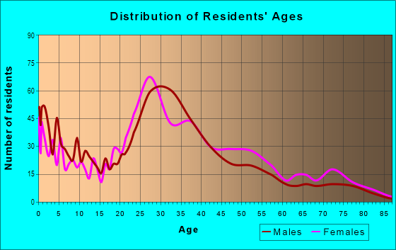
| Males: | 7,606 |
| Females: | 6,647 |
| Males: | 43.2 years |
| Females: | 36.9 years |
Average household size:
| Liberty Area: | 2.4 people |
| Kentucky: | 2.4 people |
Percentage of family households:
| Liberty Area: | 22.9% |
| Kentucky: | 45.9% |
| Here: | 23.6% |
| Kentucky: | 47.1% |
Percentage of married-couple families with children (among all households):
| Liberty Area: | 42.0% |
| Kentucky: | 58.4% |
Percentage of single-mother households (among all households):
| Liberty Area: | 6.3% |
| Kentucky: | 9.3% |
Percentage of never married males 15 years old and over:
Percentage of never married females 15 years old and over:
| Liberty Area: | 25.8% |
| Kentucky: | 16.3% |
Percentage of never married females 15 years old and over:
| Liberty Area: | 19.5% |
| Kentucky: | 13.5% |
Percentage of people that speak English not well or not at all:
| Liberty Area: | 0.7% |
| Kentucky: | 1.1% |
Percentage of people born in this state:
Percentage of people born in another U.S. state:
Percentage of native residents but born outside the U.S.:
Percentage of foreign born residents:
| Here: | 66.4% |
| Kentucky: | 67.2% |
Percentage of people born in another U.S. state:
| Liberty Area: | 22.4% |
| Kentucky: | 28.0% |
Percentage of native residents but born outside the U.S.:
| Here: | 2.4% |
| Kentucky: | 0.8% |
Percentage of foreign born residents:
| Here: | 8.8% |
| Kentucky: | 4.0% |
Owner-occupied
Renter-occupied

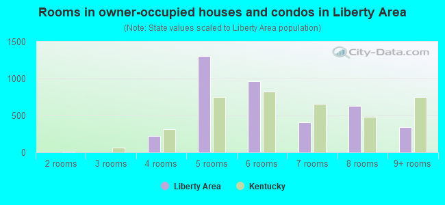
- Rooms in owner-occupied houses and condos in Liberty Area
- 01 room
- 02 rooms
- 03 rooms
- 2244 rooms
- 1,3075 rooms
- 9636 rooms
- 4077 rooms
- 6308 rooms
- 3399+ rooms
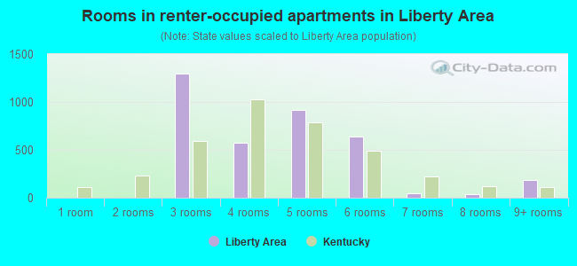
- Rooms in renter-occupied apartments in Liberty Area
- 01 room
- 02 rooms
- 1,2983 rooms
- 5724 rooms
- 9165 rooms
- 6426 rooms
- 457 rooms
- 378 rooms
- 1879+ rooms
Owner-occupied
Renter-occupied
- Bedrooms in owner-occupied houses and condos in Liberty Area
- 0no bedroom
- 01 bedroom
- 8942 bedrooms
- 2,1553 bedrooms
- 5194 bedrooms
- 1515+ bedrooms
- Bedrooms in renter-occupied apartments in Liberty Area
- 0no bedroom
- 2,1341 bedroom
- 7532 bedrooms
- 5713 bedrooms
- 04 bedrooms
- 1875+ bedrooms
Average number of cars or other vehicles available in houses/condos:
Average number of cars or other vehicles available in apartments:
| This neighborhood: | 1.8 |
| Kentucky: | 2.1 |
Average number of cars or other vehicles available in apartments:
| Here: | 1.2 |
| Kentucky: | 1.3 |
Percentage of units with a mortgage:
| Liberty Area: | 72.7% |
| Kentucky: | 56.7% |
Average estimated value of detached houses in 2022 (65.1% of all units):
| Liberty Area: | $190,876 |
| Kentucky: | $256,452 |
- Year house built in Liberty Area
- 372020 or later
- 5562010 to 2019
- 2132000 to 2009
- 1,6501990 to 1999
- 7101980 to 1989
- 1,5061970 to 1979
- 1,1691960 to 1969
- 1,0391950 to 1959
- 1,3471940 to 1949
- 2701939 or earlier
Travel time to work (commute)
![Travel time to work (commute)]()
- 107Less than 5 minutes
- 1,0585 to 9 minutes
- 1,20310 to 14 minutes
- 2,02515 to 19 minutes
- 1,41920 to 24 minutes
- 83625 to 29 minutes
- 65330 to 34 minutes
- 71635 to 39 minutes
- 13940 to 44 minutes
- 5345 to 59 minutes
- 28660 to 89 minutes
- 25290 or more minutes

Means of transportation to work
![Means of transportation to work]()
- 83.3%5,941Drove a car alone
- 7.4%529Carpooled
- 1.9%135Bus
- 2.2%156Motorcycle
- 1.5%109Walked
- 7.4%528Other means
- 4.3%309Worked at home

Time leaving home to go to work
![Time leaving home to go to work]()
- 9212:00 a.m. to 4:59 a.m.
- 865:00 a.m. to 5:29 a.m.
- 4595:30 a.m. to 5:59 a.m.
- 4336:00 a.m. to 6:29 a.m.
- 6446:30 a.m. to 6:59 a.m.
- 1,0787:00 a.m. to 7:29 a.m.
- 9357:30 a.m. to 7:59 a.m.
- 8568:00 a.m. to 8:29 a.m.
- 4388:30 a.m. to 8:59 a.m.
- 4379:00 a.m. to 9:59 a.m.
- 35610:00 a.m. to 10:59 a.m.
- 9211:00 a.m. to 11:59 a.m.
- 89012:00 p.m. to 3:59 p.m.
- 7784:00 p.m. to 11:59 p.m.

Occupations of males:
- Percentage of males in management occupations (except farmers):
Here: 13.0% Kentucky: 10.7%
- Percentage of males in business and financial operations occupations:
Here: 1.9% Kentucky: 4.0%
- Percentage of males in legal occupations:
Here: 2.5% Kentucky: 0.8%
- Percentage of males in arts, design, entertainment, sports, and media occupations:
Here: 2.7% Kentucky: 1.3%
- Percentage of males in healthcare practitioners and technical occupations:
Here: 10.4% Kentucky: 3.1%
- Percentage of males in service occupations:
Here: 12.4% Kentucky: 12.5%
- Percentage of males in sales and office occupations:
Here: 13.3% Kentucky: 14.0%
- Percentage of males in construction, extraction, and maintenance occupations:
Here: 5.4% Kentucky: 8.7%
- Percentage of males in production occupations:
Here: 15.1% Kentucky: 12.3%
- Percentage of males in transportation occupations:
Here: 5.7% Kentucky: 6.7%
- Percentage of males in material moving occupations:
Here: 10.2% Kentucky: 7.7%
Occupations of females:
- Percentage of females in management occupations (except farmers):
Here: 4.7% Kentucky: 8.4%
- Percentage of females in business and financial operations occupations:
Here: 5.0% Kentucky: 5.3%
- Percentage of females in life, physical, and social science occupations:
Here: 3.5% Kentucky: 0.8%
- Percentage of females in community and social services occupations:
Here: 8.3% Kentucky: 2.8%
- Percentage of females in legal occupations:
Here: 3.6% Kentucky: 1.1%
- Percentage of females in education, training, and library occupations:
Here: 6.7% Kentucky: 9.3%
- Percentage of females in arts, design, entertainment, sports, and media occupations:
Here: 7.9% Kentucky: 1.5%
- Percentage of females in healthcare practitioners and technical occupations:
Here: 10.8% Kentucky: 11.8%
- Percentage of females in service occupations:
Here: 22.0% Kentucky: 19.1%
- Percentage of females in sales and office occupations:
Here: 11.0% Kentucky: 27.8%
- Percentage of females in production occupations:
Here: 11.6% Kentucky: 5.2%
- Percentage of females in material moving occupations:
Here: 4.0% Kentucky: 3.2%
Percentage of people 16-64 in Armed Forces:
| Liberty Area: | 0.0% |
| Kentucky: | 0.6% |
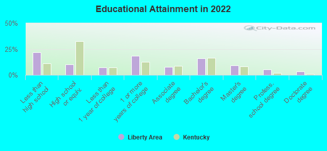
Education in this neighborhood (subdivision or community):
- Percentage of people 3 years and older in K-12 schools:
Liberty Area: 20.1% Kentucky: 16.5%
- Percentage of people 3 years and older in undergraduate colleges:
Liberty Area: 7.0% Kentucky: 4.1%
- Percentage of people 3 years and older in grad. or professional schools:
Liberty Area: 3.8% Kentucky: 1.3%
- Percentage of students K-12 enrolled in private schools:
Liberty Area: 35.4% Kentucky: 16.3%
Percentage of population below poverty level:
| Liberty Area: | 21.9% |
| Kentucky: | 16.5% |
Median year owner moved in (as recorded in 2022):
Median year renter moved in (as recorded in 2022):
| Liberty Area: | 2009 |
| Kentucky: | 2010 |
Median year renter moved in (as recorded in 2022):
| Liberty Area: | 2017 |
| Kentucky: | 2020 |
Percentage of married-couple families with both working:
| Liberty Area: | 96.7% |
| Kentucky: | 70.7% |
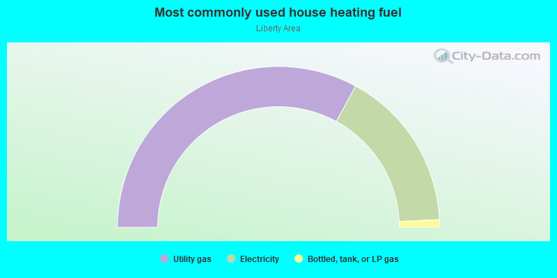
- 65.9%Utility gas
- 32.6%Electricity
- 1.5%Bottled, tank, or LP gas
Limited-access highways (interstate or state) in this neighborhood:
I- 75
Length: 2.44 miles
Directions: N-S, SE-NW
Directions: N-S, SE-NW
Highways in this neighborhood:
US Hwy 25 Byp (E New Circle Rd, State Hwy 4, US Hwy 421 Byp)
Length: 1.57 miles
Direction: N-S
Address range: 971 to 1349
Direction: N-S
Address range: 971 to 1349
Roads and streets:
Sir Barton Way
Length: 3.66 miles
Directions: E-W, N-S, SE-NW, SW-NE
Address range: 2100 to 2161
Directions: E-W, N-S, SE-NW, SW-NE
Address range: 2100 to 2161
Liberty Rd
Length: 2.72 miles
Directions: E-W, SE-NW
Address range: 1606 to 2685
Directions: E-W, SE-NW
Address range: 1606 to 2685
Man O War Blvd
Length: 2.40 miles
Directions: N-S, SW-NE
Address range: 6433 to 6539
Directions: N-S, SW-NE
Address range: 6433 to 6539
Star Shoot Pkwy
Length: 1.63 miles
Directions: E-W, SW-NE
Directions: E-W, SW-NE
Pink Pigeon Pkwy
Length: 1.48 miles
Directions: E-W, N-S, SE-NW
Address range: 2900 to 2909
Directions: E-W, N-S, SE-NW
Address range: 2900 to 2909
Stonewood Ln
Length: 1.30 miles
Directions: E-W, N-S, SE-NW, SW-NE
Address range: 2000 to 2404
Directions: E-W, N-S, SE-NW, SW-NE
Address range: 2000 to 2404
Vendor Way
Length: 1.10 miles
Directions: E-W, N-S, SE-NW, SW-NE
Directions: E-W, N-S, SE-NW, SW-NE
Fortune Dr
Length: 1.09 miles
Directions: N-S, SE-NW, SW-NE
Address range: 2316 to 2498
Directions: N-S, SE-NW, SW-NE
Address range: 2316 to 2498
Wilderness Rd
Length: 1.05 miles
Directions: E-W, N-S, SE-NW, SW-NE
Address range: 501 to 798
Directions: E-W, N-S, SE-NW, SW-NE
Address range: 501 to 798
Pavilion Way
Length: 0.83 miles
Directions: E-W, N-S, SE-NW, SW-NE
Directions: E-W, N-S, SE-NW, SW-NE
Red Leaf Dr
Length: 0.75 miles
Directions: E-W, N-S, SE-NW, SW-NE
Address range: 2600 to 2899
Directions: E-W, N-S, SE-NW, SW-NE
Address range: 2600 to 2899
Alysheba Way
Length: 0.73 miles
Directions: E-W, N-S, SW-NE
Address range: 1800 to 1899
Directions: E-W, N-S, SW-NE
Address range: 1800 to 1899
Beasley St
Length: 0.65 miles
Directions: E-W, N-S, SE-NW, SW-NE
Address range: 900 to 999
Directions: E-W, N-S, SE-NW, SW-NE
Address range: 900 to 999
Cornerstone Dr
Length: 0.61 miles
Directions: E-W, SE-NW, SW-NE
Address range: 2000 to 2299
Directions: E-W, SE-NW, SW-NE
Address range: 2000 to 2299
Aristocracy Cir
Length: 0.61 miles
Directions: E-W, N-S, SE-NW, SW-NE
Directions: E-W, N-S, SE-NW, SW-NE
Ridgebrook Rd
Length: 0.55 miles
Directions: E-W, N-S, SE-NW, SW-NE
Address range: 800 to 2313
Directions: E-W, N-S, SE-NW, SW-NE
Address range: 800 to 2313
Flying Ebony Dr
Length: 0.52 miles
Directions: N-S, SE-NW
Directions: N-S, SE-NW
Kingsbury Rd
Length: 0.52 miles
Directions: N-S, SE-NW, SW-NE
Address range: 658 to 887
Directions: N-S, SE-NW, SW-NE
Address range: 658 to 887
Rockminster Rd
Length: 0.52 miles
Directions: E-W, N-S, SE-NW, SW-NE
Directions: E-W, N-S, SE-NW, SW-NE
Old Rosebud Rd
Length: 0.50 miles
Direction: E-W
Direction: E-W
Trade Center Dr
Length: 0.48 miles
Direction: E-W
Address range: 1400 to 2299
Direction: E-W
Address range: 1400 to 2299
Star Gaze Dr
Length: 0.45 miles
Directions: E-W, SE-NW
Address range: 900 to 964
Directions: E-W, SE-NW
Address range: 900 to 964
Burkwood Dr
Length: 0.39 miles
Directions: E-W, N-S, SE-NW, SW-NE
Address range: 800 to 915
Directions: E-W, N-S, SE-NW, SW-NE
Address range: 800 to 915
Ogden Way
Length: 0.38 miles
Directions: N-S, SE-NW
Directions: N-S, SE-NW
Princess Doreen Dr
Length: 0.38 miles
Directions: E-W, SW-NE
Address range: 900 to 952
Directions: E-W, SW-NE
Address range: 900 to 952
Gerardi Rd
Length: 0.38 miles
Directions: E-W, N-S, SE-NW, SW-NE
Address range: 800 to 999
Directions: E-W, N-S, SE-NW, SW-NE
Address range: 800 to 999
Village Green Ave
Length: 0.37 miles
Direction: SW-NE
Address range: 901 to 985
Direction: SW-NE
Address range: 901 to 985
Appletree Ln
Length: 0.36 miles
Direction: SW-NE
Address range: 600 to 899
Direction: SW-NE
Address range: 600 to 899
Brock McVey Dr
Length: 0.35 miles
Directions: N-S, SE-NW, SW-NE
Address range: 1100 to 1199
Directions: N-S, SE-NW, SW-NE
Address range: 1100 to 1199
Christian Rd
Length: 0.34 miles
Directions: E-W, N-S, SE-NW, SW-NE
Address range: 2100 to 2200
Directions: E-W, N-S, SE-NW, SW-NE
Address range: 2100 to 2200
Courtney Ave
Length: 0.34 miles
Directions: E-W, N-S, SE-NW, SW-NE
Address range: 1700 to 1899
Directions: E-W, N-S, SE-NW, SW-NE
Address range: 1700 to 1899
Liberty Hill Dr
Length: 0.34 miles
Directions: N-S, SE-NW, SW-NE
Address range: 689 to 799
Directions: N-S, SE-NW, SW-NE
Address range: 689 to 799
Jingle Bell Ln
Length: 0.33 miles
Direction: E-W
Address range: 1400 to 1499
Direction: E-W
Address range: 1400 to 1499
Franks Way
Length: 0.32 miles
Directions: N-S, SE-NW
Address range: 2076 to 2489
Directions: N-S, SE-NW
Address range: 2076 to 2489
Braden Way
Length: 0.32 miles
Directions: E-W, N-S, SE-NW, SW-NE
Directions: E-W, N-S, SE-NW, SW-NE
Woodward Ln
Length: 0.32 miles
Direction: SW-NE
Address range: 600 to 799
Direction: SW-NE
Address range: 600 to 799
Creative Dr
Length: 0.31 miles
Directions: E-W, N-S, SE-NW, SW-NE
Address range: 2000 to 2049
Directions: E-W, N-S, SE-NW, SW-NE
Address range: 2000 to 2049
Brown Ave
Length: 0.31 miles
Direction: SE-NW
Address range: 113 to 213
Direction: SE-NW
Address range: 113 to 213
Plaudit Pl
Length: 0.31 miles
Direction: SW-NE
Address range: 1850 to 1897
Direction: SW-NE
Address range: 1850 to 1897
Hadon Dr
Length: 0.30 miles
Directions: E-W, SE-NW
Address range: 2100 to 2199
Directions: E-W, SE-NW
Address range: 2100 to 2199
Crystal Falls Rd
Length: 0.30 miles
Directions: E-W, N-S, SW-NE
Address range: 2600 to 2799
Directions: E-W, N-S, SW-NE
Address range: 2600 to 2799
Revere Run Dr
Length: 0.29 miles
Directions: E-W, SE-NW, SW-NE
Address range: 800 to 999
Directions: E-W, SE-NW, SW-NE
Address range: 800 to 999
Astarita Way
Length: 0.29 miles
Directions: N-S, SE-NW
Address range: 2425 to 2489
Directions: N-S, SE-NW
Address range: 2425 to 2489
Morgan Hills Dr
Length: 0.28 miles
Directions: E-W, N-S, SE-NW, SW-NE
Address range: 601 to 799
Directions: E-W, N-S, SE-NW, SW-NE
Address range: 601 to 799
Rambling Creek Dr
Length: 0.28 miles
Directions: E-W, SE-NW, SW-NE
Address range: 700 to 799
Directions: E-W, SE-NW, SW-NE
Address range: 700 to 799
Fortune Hill Ln
Length: 0.27 miles
Directions: E-W, N-S, SE-NW, SW-NE
Address range: 2100 to 2199
Directions: E-W, N-S, SE-NW, SW-NE
Address range: 2100 to 2199
Eastmont Rd
Length: 0.27 miles
Directions: E-W, SE-NW, SW-NE
Address range: 829 to 899
Directions: E-W, SE-NW, SW-NE
Address range: 829 to 899
Belmere Dr
Length: 0.25 miles
Directions: E-W, SW-NE
Address range: 900 to 965
Directions: E-W, SW-NE
Address range: 900 to 965
Nickwood Trl
Length: 0.25 miles
Directions: N-S, SE-NW, SW-NE
Directions: N-S, SE-NW, SW-NE
Ashton Dr
Length: 0.23 miles
Directions: E-W, SE-NW
Address range: 101 to 199
Directions: E-W, SE-NW
Address range: 101 to 199
Glass Ave
Length: 0.23 miles
Direction: SE-NW
Address range: 1 to 123
Direction: SE-NW
Address range: 1 to 123
James Ct
Length: 0.23 miles
Directions: E-W, N-S, SE-NW
Address range: 100 to 198
Directions: E-W, N-S, SE-NW
Address range: 100 to 198
Wyatt Pkwy
Length: 0.22 miles
Direction: SE-NW
Address range: 1700 to 1799
Direction: SE-NW
Address range: 1700 to 1799
Danby Woods Dr
Length: 0.22 miles
Directions: N-S, SE-NW, SW-NE
Address range: 600 to 699
Directions: N-S, SE-NW, SW-NE
Address range: 600 to 699
Knightsbridge Ln
Length: 0.21 miles
Directions: N-S, SW-NE
Address range: 2565 to 2599
Directions: N-S, SW-NE
Address range: 2565 to 2599
Star of Danube Way
Length: 0.21 miles
Directions: E-W, N-S, SE-NW, SW-NE
Address range: 900 to 932
Directions: E-W, N-S, SE-NW, SW-NE
Address range: 900 to 932
Ridgefield Ln
Length: 0.21 miles
Directions: E-W, SE-NW
Address range: 2500 to 2541
Directions: E-W, SE-NW
Address range: 2500 to 2541
Danielle Ln
Length: 0.21 miles
Directions: N-S, SW-NE
Address range: 2500 to 2570
Directions: N-S, SW-NE
Address range: 2500 to 2570
Benwood Dr
Length: 0.20 miles
Directions: E-W, SE-NW, SW-NE
Address range: 1700 to 1799
Directions: E-W, SE-NW, SW-NE
Address range: 1700 to 1799
Kenwood Dr
Length: 0.19 miles
Direction: SE-NW
Address range: 2200 to 2299
Direction: SE-NW
Address range: 2200 to 2299
Mackenzie Ln
Length: 0.19 miles
Direction: SW-NE
Direction: SW-NE
Paul Jones Way
Length: 0.18 miles
Directions: E-W, SE-NW
Address range: 2100 to 2198
Directions: E-W, SE-NW
Address range: 2100 to 2198
Marblehead Dr
Length: 0.18 miles
Direction: SW-NE
Address range: 846 to 915
Direction: SW-NE
Address range: 846 to 915
Crusaders Way
Length: 0.16 miles
Directions: N-S, SW-NE
Address range: 2500 to 2527
Directions: N-S, SW-NE
Address range: 2500 to 2527
Pleasant Ridge Dr
Length: 0.15 miles
Direction: SE-NW
Address range: 2000 to 2091
Direction: SE-NW
Address range: 2000 to 2091
Family Cir
Length: 0.15 miles
Directions: E-W, SW-NE
Address range: 2000 to 2091
Directions: E-W, SW-NE
Address range: 2000 to 2091
Lakeview Dr
Length: 0.15 miles
Direction: SW-NE
Address range: 700 to 799
Direction: SW-NE
Address range: 700 to 799
Fortune Ct
Length: 0.15 miles
Direction: E-W
Address range: 1700 to 1748
Direction: E-W
Address range: 1700 to 1748
Pridemore Ct
Length: 0.14 miles
Directions: E-W, SW-NE
Address range: 1360 to 1389
Directions: E-W, SW-NE
Address range: 1360 to 1389
Livania Ln
Length: 0.14 miles
Direction: SW-NE
Address range: 800 to 899
Direction: SW-NE
Address range: 800 to 899
Johnsdale Dr
Length: 0.14 miles
Directions: E-W, SW-NE
Address range: 800 to 899
Directions: E-W, SW-NE
Address range: 800 to 899
Walsh Ct
Length: 0.13 miles
Direction: SE-NW
Address range: 2100 to 2299
Direction: SE-NW
Address range: 2100 to 2299
Gunpowder Dr
Length: 0.13 miles
Direction: SW-NE
Address range: 800 to 899
Direction: SW-NE
Address range: 800 to 899
Lady Bedford Pl
Length: 0.13 miles
Directions: E-W, N-S, SE-NW
Directions: E-W, N-S, SE-NW
Gatehouse Pl
Length: 0.13 miles
Direction: SW-NE
Address range: 700 to 766
Direction: SW-NE
Address range: 700 to 766
Ellison Ct
Length: 0.13 miles
Directions: N-S, SW-NE
Address range: 700 to 799
Directions: N-S, SW-NE
Address range: 700 to 799
Downs Ave
Length: 0.12 miles
Direction: SW-NE
Address range: 700 to 799
Direction: SW-NE
Address range: 700 to 799
Calgary
Length: 0.12 miles
Direction: E-W
Direction: E-W
Paradise Ln
Length: 0.12 miles
Directions: E-W, N-S, SE-NW
Address range: 100 to 772
Directions: E-W, N-S, SE-NW
Address range: 100 to 772
Maxima
Length: 0.12 miles
Direction: SE-NW
Direction: SE-NW
Cannock Dr
Length: 0.12 miles
Direction: SE-NW
Direction: SE-NW
Whispering Brook Trce
Length: 0.12 miles
Directions: E-W, N-S, SW-NE
Address range: 700 to 799
Directions: E-W, N-S, SW-NE
Address range: 700 to 799
Republic Ct
Length: 0.11 miles
Directions: E-W, SW-NE
Address range: 600 to 699
Directions: E-W, SW-NE
Address range: 600 to 699
Atilya Pl
Length: 0.10 miles
Direction: SW-NE
Address range: 1162 to 1199
Direction: SW-NE
Address range: 1162 to 1199
Harrigan Way
Length: 0.10 miles
Direction: N-S
Direction: N-S
Lighthouse Ln
Length: 0.09 miles
Direction: E-W
Address range: 2100 to 2125
Direction: E-W
Address range: 2100 to 2125
Healy Ln
Length: 0.09 miles
Directions: N-S, SW-NE
Address range: 2404 to 2425
Directions: N-S, SW-NE
Address range: 2404 to 2425
Liberty Station Ct
Length: 0.08 miles
Direction: SE-NW
Address range: 2300 to 2328
Direction: SE-NW
Address range: 2300 to 2328
Amalfi Ln
Length: 0.08 miles
Directions: E-W, SE-NW, SW-NE
Address range: 800 to 899
Directions: E-W, SE-NW, SW-NE
Address range: 800 to 899
Decleration Ct
Length: 0.08 miles
Direction: SW-NE
Address range: 622 to 699
Direction: SW-NE
Address range: 622 to 699
Emery Ct
Length: 0.08 miles
Direction: SW-NE
Address range: 500 to 599
Direction: SW-NE
Address range: 500 to 599
Rider Aly
Length: 0.07 miles
Direction: SW-NE
Direction: SW-NE
Checkerberry Dr
Length: 0.07 miles
Direction: SE-NW
Address range: 2400 to 2411
Direction: SE-NW
Address range: 2400 to 2411
Lindy Ct
Length: 0.07 miles
Direction: SE-NW
Address range: 1700 to 1799
Direction: SE-NW
Address range: 1700 to 1799
Arthur Way
Length: 0.07 miles
Direction: SE-NW
Address range: 2200 to 2299
Direction: SE-NW
Address range: 2200 to 2299
Woods Ave
Length: 0.07 miles
Direction: SW-NE
Address range: 100 to 199
Direction: SW-NE
Address range: 100 to 199
Forston Ave
Length: 0.07 miles
Direction: SW-NE
Address range: 100 to 199
Direction: SW-NE
Address range: 100 to 199
Haddon Dr
Length: 0.07 miles
Direction: SE-NW
Direction: SE-NW
Rawlings Ct
Length: 0.06 miles
Direction: SE-NW
Address range: 2200 to 2299
Direction: SE-NW
Address range: 2200 to 2299
Danby Woods Ct
Length: 0.06 miles
Direction: SE-NW
Address range: 2400 to 2499
Direction: SE-NW
Address range: 2400 to 2499
Pleasant Creek Ln
Length: 0.06 miles
Direction: N-S
Address range: 2700 to 2799
Direction: N-S
Address range: 2700 to 2799
Ridgebrook Ct
Length: 0.06 miles
Directions: E-W, SW-NE
Address range: 2300 to 2399
Directions: E-W, SW-NE
Address range: 2300 to 2399
Rope Aly
Length: 0.06 miles
Directions: N-S, SE-NW, SW-NE
Directions: N-S, SE-NW, SW-NE
Ridgebrook Cir
Length: 0.05 miles
Direction: SE-NW
Address range: 775 to 799
Direction: SE-NW
Address range: 775 to 799
Justin Pl
Length: 0.05 miles
Directions: N-S, SE-NW
Address range: 2400 to 2499
Directions: N-S, SE-NW
Address range: 2400 to 2499
Independence Ct
Length: 0.05 miles
Direction: SE-NW
Address range: 2300 to 2328
Direction: SE-NW
Address range: 2300 to 2328
Stable Aly
Length: 0.05 miles
Direction: SE-NW
Direction: SE-NW
Patrick Henry Way
Length: 0.05 miles
Direction: SE-NW
Address range: 2500 to 2599
Direction: SE-NW
Address range: 2500 to 2599
Ellison Pl
Length: 0.05 miles
Direction: SE-NW
Address range: 1800 to 1899
Direction: SE-NW
Address range: 1800 to 1899
Patriot Ct
Length: 0.05 miles
Direction: SW-NE
Address range: 600 to 699
Direction: SW-NE
Address range: 600 to 699
Ranch Aly
Length: 0.05 miles
Direction: SW-NE
Direction: SW-NE
Chasemore Ct
Length: 0.04 miles
Directions: E-W, SE-NW
Address range: 2200 to 2299
Directions: E-W, SE-NW
Address range: 2200 to 2299
Hutch Aly
Length: 0.04 miles
Direction: SE-NW
Direction: SE-NW
Boxer Way
Length: 0.04 miles
Direction: SW-NE
Direction: SW-NE
Red Leaf Ct
Length: 0.04 miles
Direction: SW-NE
Address range: 800 to 899
Direction: SW-NE
Address range: 800 to 899
Little Silver Ct
Length: 0.04 miles
Direction: SW-NE
Address range: 800 to 899
Direction: SW-NE
Address range: 800 to 899
Cliffmore Ct
Length: 0.04 miles
Directions: N-S, SE-NW
Address range: 2200 to 2213
Directions: N-S, SE-NW
Address range: 2200 to 2213
Country Hills Cir
Length: 0.04 miles
Direction: SE-NW
Address range: 2300 to 2399
Direction: SE-NW
Address range: 2300 to 2399
Shetland Dr
Length: 0.03 miles
Direction: SE-NW
Direction: SE-NW
Strader Dr
Length: 0.03 miles
Direction: SE-NW
Address range: 1667 to 1798
Direction: SE-NW
Address range: 1667 to 1798
Misty Cove Rd
Length: 0.03 miles
Direction: SE-NW
Address range: 2700 to 2799
Direction: SE-NW
Address range: 2700 to 2799
Railroad features:
Chesapeake and Ohio Rlwy
Length: 0.19 miles
Direction: E-W
Direction: E-W
Other features:
Bryan Station Crk
Length: 1.21 miles
Directions: E-W, N-S, SE-NW, SW-NE
Directions: E-W, N-S, SE-NW, SW-NE
North Elkhorn Crk
Length: 0.96 miles
Directions: E-W, N-S, SE-NW, SW-NE
Directions: E-W, N-S, SE-NW, SW-NE