Maplewood neighborhood in Malden, Massachusetts (MA), 02148 detailed profile
Settings
X


Business Search - 14 Million verified businesses
Area: 0.717 square miles
Population: 9,376
Population density:
| Maplewood: | 13,075 people per square mile |
| Malden: | 12,754 people per square mile |

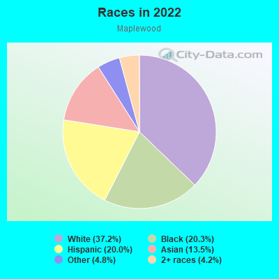
- 3,77637.2%White
- 2,05920.3%Black
- 2,02720.0%Hispanic or Latino
- 1,37213.5%Asian
- 4904.8%Some other race
- 4294.2%Two or more races
Distribution of median household income
![Distribution of median household income]()
- 241Less than $10,000
- 224$10,000 to $19,999
- 570$20,000 to $29,999
- 771$30,000 to $39,999
- 487$40,000 to $49,999
- 710$50,000 to $59,999
- 130$60,000 to $74,999
- 491$75,000 to $99,999
- 316$100,000 to $124,999
- 334$125,000 to $149,999
- 412$150,000 to $199,999
- 610$200,000 or more

Distribution of owner-occupied house/condo value
![Distribution of owner-occupied house/condo value]()
- 220$50,000 to $99,999
- 32$150,000 to $199,999
- 125$200,000 to $249,999
- 83$250,000 to $299,999
- 551$300,000 to $399,999
- 398$400,000 to $499,999
- 806$500,000 to $749,999
- 333$750,000 to $999,999
- 256$1,000,000 or more

Distribution of rent paid by renters
![Distribution of rent paid by renters]()
- 90Less than $100
- 272$100 to $199
- 432$200 to $299
- 282$300 to $399
- 1,438$400 to $499
- 34$500 to $599
- 212$600 to $699
- 341$700 to $799
- 120$800 to $899
- 172$900 to $999
- 279$1,000 to $1,249
- 288$1,250 to $1,499
- 595$1,500 to $1,999
- 1,044$2,000 or more

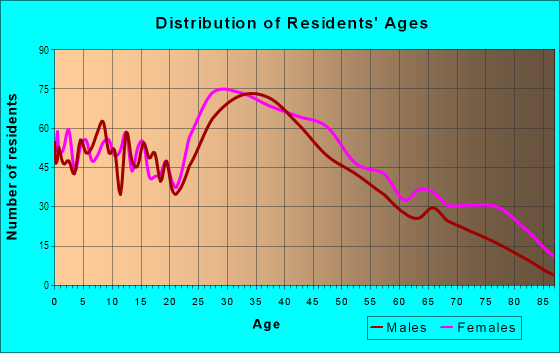
| Males: | 4,638 |
| Females: | 4,737 |
Males:
| This neighborhood: | 31.9 years |
| Whole city: | 34.9 years |
| This neighborhood: | 38.9 years |
| Whole city: | 40.2 years |
Average household size:
| Maplewood: | 2.6 people |
| Malden: | 2.5 people |
Percentage of family households:
| Maplewood: | 61.4% |
| Malden: | 42.0% |
| Here: | 46.9% |
| Malden: | 44.9% |
Percentage of married-couple families with children (among all households):
| Maplewood: | 30.0% |
| Malden: | 30.9% |
Percentage of single-mother households (among all households):
| Maplewood: | 16.5% |
| Malden: | 5.9% |
Percentage of never married males 15 years old and over:
Percentage of never married females 15 years old and over:
| Maplewood: | 22.7% |
| Malden: | 26.1% |
Percentage of never married females 15 years old and over:
| Maplewood: | 17.5% |
| city: | 17.6% |
Percentage of people that speak English not well or not at all:
| Maplewood: | 12.0% |
| Malden: | 11.8% |
Percentage of people born in this state:
Percentage of people born in another U.S. state:
Percentage of native residents but born outside the U.S.:
Percentage of foreign born residents:
| Here: | 47.8% |
| Malden: | 39.4% |
Percentage of people born in another U.S. state:
| Maplewood: | 8.8% |
| Malden: | 17.4% |
Percentage of native residents but born outside the U.S.:
| Here: | 2.9% |
| city: | 1.3% |
Percentage of foreign born residents:
| Here: | 40.5% |
| Malden: | 41.9% |
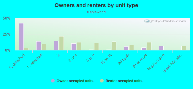
Owner-occupied
Renter-occupied

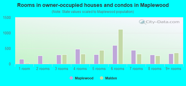
- Rooms in owner-occupied houses and condos in Maplewood
- 1621 room
- 2642 rooms
- 2973 rooms
- 4784 rooms
- 3105 rooms
- 5986 rooms
- 4497 rooms
- 2988 rooms
- 3339+ rooms
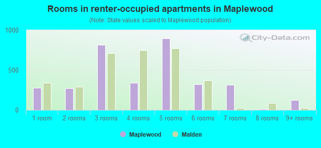
- Rooms in renter-occupied apartments in Maplewood
- 2801 room
- 2692 rooms
- 8143 rooms
- 3394 rooms
- 8965 rooms
- 3246 rooms
- 3167 rooms
- 108 rooms
- 1259+ rooms
Owner-occupied
Renter-occupied
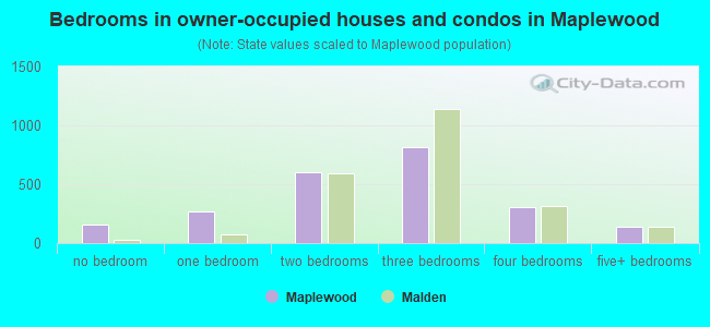
- Bedrooms in owner-occupied houses and condos in Maplewood
- 162no bedroom
- 2651 bedroom
- 6022 bedrooms
- 8163 bedrooms
- 3014 bedrooms
- 1395+ bedrooms
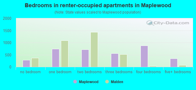
- Bedrooms in renter-occupied apartments in Maplewood
- 280no bedroom
- 7401 bedroom
- 7192 bedrooms
- 5553 bedrooms
- 8814 bedrooms
- 3465+ bedrooms
Average number of cars or other vehicles available in houses/condos:
Average number of cars or other vehicles available in apartments:
| This neighborhood: | 1.5 |
| Malden: | 1.6 |
Average number of cars or other vehicles available in apartments:
| Here: | |
| city: |
Percentage of units with a mortgage:
| Maplewood: | 75.8% |
| Malden: | 66.3% |
Housing prices:
- Average estimated value of detached houses in 2022 (31.0% of all units):
Maplewood: $619,297 Malden: $603,493
- Average estimated value of townhouses or other attached units in 2022 (17.8% of all units):
This neighborhood: $655,335 city: $424,080
- Average estimated value of housing units in 2-unit structures in 2022 (26.4% of all units):
This neighborhood: $600,727 Malden: $833,835
- Average estimated '22 value of housing units in 3-to-4-unit structures (16.3% of all units):
Maplewood: $628,584 city: $415,773
- Average estimated '22 value of housing units in 5-or-more-unit structures (6.5% of all units):
Maplewood: $424,404 Malden: $266,826
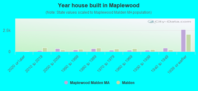
- Year house built in Maplewood
- 02020 or later
- 1362010 to 2019
- 3632000 to 2009
- 2121990 to 1999
- 3651980 to 1989
- 1781970 to 1979
- 1741960 to 1969
- 1881950 to 1959
- 4221940 to 1949
- 2,6071939 or earlier
City-data.com crime index for city in 2020 (higher means more crime):
| City: | 132.7 |
| U.S. average: | 219.5 |
Travel time to work (commute)
![Travel time to work (commute)]()
- 61Less than 5 minutes
- 3625 to 9 minutes
- 23010 to 14 minutes
- 28015 to 19 minutes
- 71320 to 24 minutes
- 14625 to 29 minutes
- 61630 to 34 minutes
- 17535 to 39 minutes
- 31540 to 44 minutes
- 80045 to 59 minutes
- 60560 to 89 minutes
- 12490 or more minutes

Means of transportation to work
![Means of transportation to work]()
- 53.0%2,594Drove a car alone
- 14.2%696Carpooled
- 4.5%218Bus
- 12.9%629Subway or elevated rail
- 3.1%151Long-distance train or commuter rail
- 3.0%149Bicycle
- 19.4%948Walked
- 1.2%61Other means
- 10.3%502Worked at home

Time leaving home to go to work
![Time leaving home to go to work]()
- 15712:00 a.m. to 4:59 a.m.
- 2175:00 a.m. to 5:29 a.m.
- 1005:30 a.m. to 5:59 a.m.
- 4856:00 a.m. to 6:29 a.m.
- 4066:30 a.m. to 6:59 a.m.
- 4867:00 a.m. to 7:29 a.m.
- 3297:30 a.m. to 7:59 a.m.
- 4438:00 a.m. to 8:29 a.m.
- 1938:30 a.m. to 8:59 a.m.
- 4369:00 a.m. to 9:59 a.m.
- 19810:00 a.m. to 10:59 a.m.
- 5711:00 a.m. to 11:59 a.m.
- 45512:00 p.m. to 3:59 p.m.
- 4824:00 p.m. to 11:59 p.m.

Occupations of males:
- Percentage of males in management occupations (except farmers):
Here: 7.6% city: 9.4%
- Percentage of males in business and financial operations occupations:
Here: 3.7% city: 6.5%
- Percentage of males in computer and mathematical occupations:
Here: 3.9% city: 12.0%
- Percentage of males in architecture and engineering occupations:
Here: 2.2% city: 7.3%
- Percentage of males in education, training, and library occupations:
Here: 4.1% city: 3.9%
- Percentage of males in arts, design, entertainment, sports, and media occupations:
Here: 1.0% city: 2.6%
- Percentage of males in healthcare practitioners and technical occupations:
Here: 4.6% city: 2.7%
- Percentage of males in service occupations:
Here: 17.1% city: 15.4%
- Percentage of males in sales and office occupations:
Here: 7.7% city: 9.4%
- Percentage of males in construction, extraction, and maintenance occupations:
Here: 27.2% city: 10.7%
- Percentage of males in production occupations:
Here: 6.6% city: 4.2%
- Percentage of males in transportation occupations:
Here: 7.0% city: 5.4%
- Percentage of males in material moving occupations:
Here: 4.4% city: 2.5%
Occupations of females:
- Percentage of females in management occupations (except farmers):
Here: 4.3% city: 12.6%
- Percentage of females in business and financial operations occupations:
Here: 6.7% city: 7.5%
- Percentage of females in computer and mathematical occupations:
Here: 4.1% city: 3.2%
- Percentage of females in life, physical, and social science occupations:
Here: 2.1% city: 2.7%
- Percentage of females in community and social services occupations:
Here: 1.0% city: 2.3%
- Percentage of females in legal occupations:
Here: 1.2% city: 1.7%
- Percentage of females in education, training, and library occupations:
Here: 5.4% city: 7.2%
- Percentage of females in arts, design, entertainment, sports, and media occupations:
Here: 1.4% city: 2.1%
- Percentage of females in healthcare practitioners and technical occupations:
Here: 13.2% city: 9.7%
- Percentage of females in service occupations:
Here: 27.1% city: 23.9%
- Percentage of females in sales and office occupations:
Here: 28.4% city: 20.6%
- Percentage of females in material moving occupations:
Here: 3.5% city: 1.1%
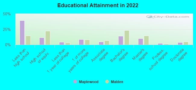
Education in this neighborhood (subdivision or community):
- Percentage of people 3 years and older in K-12 schools:
Maplewood: 34.7% Malden: 12.3%
- Percentage of people 3 years and older in undergraduate colleges:
Maplewood: 9.1% Malden: 5.5%
- Percentage of people 3 years and older in grad. or professional schools:
Maplewood: 11.4% Malden: 4.2%
- Percentage of students K-12 enrolled in private schools:
Maplewood: 10.6% Malden: 9.4%
Percentage of population below poverty level:
| Maplewood: | 17.1% |
| Malden: | 11.9% |
Median year owner moved in (as recorded in 2022):
| Maplewood: | 2005 |
| Malden: | 2008 |
Percentage of married-couple families with both working:
| Maplewood: | 99.4% |
| Malden: | 63.0% |
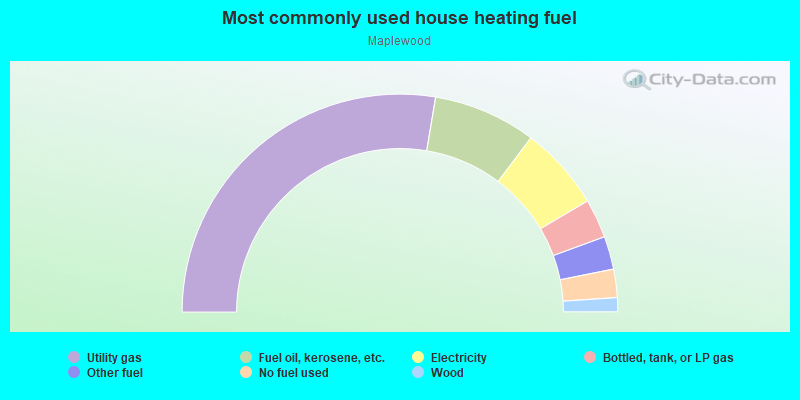
- 55.3%Utility gas
- 15.3%Fuel oil, kerosene, etc.
- 12.5%Electricity
- 5.8%Bottled, tank, or LP gas
- 4.9%Other fuel
- 4.2%No fuel used
- 2.1%Wood
Highways in this neighborhood:
State Hwy 99 (Broadway)
Length: 0.97 miles
Directions: E-W, N-S, SW-NE
Address range: 28 to 424
Directions: E-W, N-S, SW-NE
Address range: 28 to 424
Eastern Ave (State Hwy 60)
Length: 0.96 miles
Direction: E-W
Address range: 546 to 1061
Direction: E-W
Address range: 546 to 1061
Roads and streets:
Salem St
Length: 1.19 miles
Directions: E-W, SW-NE
Address range: 366 to 914
Directions: E-W, SW-NE
Address range: 366 to 914
Webster St
Length: 0.66 miles
Directions: E-W, SE-NW
Address range: 1 to 299
Directions: E-W, SE-NW
Address range: 1 to 299
Cherry St
Length: 0.57 miles
Directions: E-W, SE-NW
Address range: 1 to 181
Directions: E-W, SE-NW
Address range: 1 to 181
Maplewood St
Length: 0.52 miles
Directions: E-W, N-S, SW-NE
Address range: 1 to 299
Directions: E-W, N-S, SW-NE
Address range: 1 to 299
Bowdoin St
Length: 0.45 miles
Direction: SE-NW
Address range: 1 to 199
Direction: SE-NW
Address range: 1 to 199
Waite St (Waite St Exd)
Length: 0.41 miles
Direction: E-W
Address range: 1 to 199
Direction: E-W
Address range: 1 to 199
Granite St
Length: 0.38 miles
Directions: E-W, N-S, SW-NE
Address range: 1 to 139
Directions: E-W, N-S, SW-NE
Address range: 1 to 139
Bowman St
Length: 0.36 miles
Directions: E-W, N-S, SE-NW
Address range: 1 to 199
Directions: E-W, N-S, SE-NW
Address range: 1 to 199
Granville Ave
Length: 0.35 miles
Directions: N-S, SW-NE
Address range: 1 to 147
Directions: N-S, SW-NE
Address range: 1 to 147
Rockwell St
Length: 0.34 miles
Directions: N-S, SE-NW
Address range: 1 to 199
Directions: N-S, SE-NW
Address range: 1 to 199
Lebanon St
Length: 0.33 miles
Directions: N-S, SE-NW, SW-NE
Address range: 24 to 220
Directions: N-S, SE-NW, SW-NE
Address range: 24 to 220
Fairview Ave
Length: 0.32 miles
Directions: E-W, SW-NE
Address range: 1 to 99
Directions: E-W, SW-NE
Address range: 1 to 99
Columbia St
Length: 0.31 miles
Directions: N-S, SE-NW
Address range: 1 to 135
Directions: N-S, SE-NW
Address range: 1 to 135
Newland St
Length: 0.31 miles
Direction: E-W
Address range: 26 to 199
Direction: E-W
Address range: 26 to 199
Bainbridge St
Length: 0.30 miles
Directions: E-W, SW-NE
Address range: 1 to 139
Directions: E-W, SW-NE
Address range: 1 to 139
Valley St
Length: 0.30 miles
Directions: E-W, SE-NW
Address range: 1 to 99
Directions: E-W, SE-NW
Address range: 1 to 99
Crystal St
Length: 0.28 miles
Directions: E-W, N-S, SE-NW
Address range: 1 to 98
Directions: E-W, N-S, SE-NW
Address range: 1 to 98
Waite St Exn
Length: 0.28 miles
Direction: E-W
Address range: 1 to 56
Direction: E-W
Address range: 1 to 56
Orchard St
Length: 0.27 miles
Direction: E-W
Address range: 1 to 99
Direction: E-W
Address range: 1 to 99
N Milton St
Length: 0.26 miles
Directions: E-W, N-S, SE-NW
Address range: 1 to 99
Directions: E-W, N-S, SE-NW
Address range: 1 to 99
Garden St
Length: 0.26 miles
Direction: E-W
Address range: 1 to 99
Direction: E-W
Address range: 1 to 99
Kimball St
Length: 0.26 miles
Directions: E-W, N-S, SE-NW
Address range: 37 to 199
Directions: E-W, N-S, SE-NW
Address range: 37 to 199
Seaview Ave
Length: 0.25 miles
Directions: E-W, N-S, SW-NE
Address range: 1 to 99
Directions: E-W, N-S, SW-NE
Address range: 1 to 99
Bishop Rd
Length: 0.25 miles
Direction: E-W
Address range: 1 to 99
Direction: E-W
Address range: 1 to 99
Alden St
Length: 0.25 miles
Directions: E-W, N-S, SE-NW, SW-NE
Address range: 1 to 106
Directions: E-W, N-S, SE-NW, SW-NE
Address range: 1 to 106
Home St
Length: 0.24 miles
Directions: N-S, SW-NE
Address range: 1 to 199
Directions: N-S, SW-NE
Address range: 1 to 199
Daniels St
Length: 0.23 miles
Direction: SE-NW
Address range: 1 to 199
Direction: SE-NW
Address range: 1 to 199
Laurel St
Length: 0.22 miles
Directions: N-S, SW-NE
Address range: 1 to 199
Directions: N-S, SW-NE
Address range: 1 to 199
Dodge St
Length: 0.21 miles
Directions: E-W, SE-NW
Address range: 1 to 99
Directions: E-W, SE-NW
Address range: 1 to 99
Sheafe St
Length: 0.20 miles
Directions: E-W, N-S, SE-NW
Address range: 1 to 99
Directions: E-W, N-S, SE-NW
Address range: 1 to 99
Lisbon St
Length: 0.19 miles
Directions: E-W, N-S, SW-NE
Address range: 1 to 99
Directions: E-W, N-S, SW-NE
Address range: 1 to 99
Baker St
Length: 0.19 miles
Directions: N-S, SE-NW
Address range: 1 to 98
Directions: N-S, SE-NW
Address range: 1 to 98
Durso Ave
Length: 0.18 miles
Direction: N-S
Address range: 1 to 99
Direction: N-S
Address range: 1 to 99
Kennard St
Length: 0.18 miles
Directions: E-W, SW-NE
Address range: 1 to 99
Directions: E-W, SW-NE
Address range: 1 to 99
Noble St
Length: 0.18 miles
Direction: SE-NW
Address range: 1 to 99
Direction: SE-NW
Address range: 1 to 99
Church St
Length: 0.18 miles
Direction: N-S
Address range: 1 to 99
Direction: N-S
Address range: 1 to 99
Havelock St
Length: 0.17 miles
Direction: E-W
Address range: 1 to 99
Direction: E-W
Address range: 1 to 99
Jacob St
Length: 0.16 miles
Directions: N-S, SE-NW
Address range: 1 to 99
Directions: N-S, SE-NW
Address range: 1 to 99
Sharon St
Length: 0.16 miles
Direction: N-S
Address range: 1 to 99
Direction: N-S
Address range: 1 to 99
Hill St
Length: 0.16 miles
Direction: E-W
Address range: 32 to 199
Direction: E-W
Address range: 32 to 199
Hanover St
Length: 0.15 miles
Directions: N-S, SE-NW
Address range: 1 to 99
Directions: N-S, SE-NW
Address range: 1 to 99
Princeton Rd
Length: 0.15 miles
Direction: N-S
Address range: 1 to 99
Direction: N-S
Address range: 1 to 99
Goldcliff Rd
Length: 0.14 miles
Directions: E-W, N-S, SE-NW
Address range: 1 to 68
Directions: E-W, N-S, SE-NW
Address range: 1 to 68
Reserve St
Length: 0.14 miles
Directions: E-W, SE-NW, SW-NE
Address range: 1 to 99
Directions: E-W, SE-NW, SW-NE
Address range: 1 to 99
Willow St
Length: 0.14 miles
Directions: N-S, SW-NE
Address range: 114 to 199
Directions: N-S, SW-NE
Address range: 114 to 199
Playstead Rd
Length: 0.14 miles
Direction: E-W
Address range: 1 to 99
Direction: E-W
Address range: 1 to 99
Mount Washington Ave
Length: 0.14 miles
Directions: E-W, SE-NW
Address range: 1 to 99
Directions: E-W, SE-NW
Address range: 1 to 99
Marlboro St
Length: 0.14 miles
Direction: N-S
Address range: 1 to 99
Direction: N-S
Address range: 1 to 99
Fairview Ter
Length: 0.14 miles
Directions: E-W, SW-NE
Address range: 1 to 55
Directions: E-W, SW-NE
Address range: 1 to 55
Division St
Length: 0.14 miles
Direction: N-S
Address range: 1 to 99
Direction: N-S
Address range: 1 to 99
Cross St
Length: 0.13 miles
Directions: N-S, SE-NW
Address range: 552 to 699
Directions: N-S, SE-NW
Address range: 552 to 699
Rockwell Ter
Length: 0.13 miles
Direction: E-W
Address range: 1 to 99
Direction: E-W
Address range: 1 to 99
Webber St
Length: 0.13 miles
Directions: N-S, SW-NE
Address range: 1 to 99
Directions: N-S, SW-NE
Address range: 1 to 99
Preston St
Length: 0.13 miles
Directions: N-S, SE-NW, SW-NE
Address range: 1 to 52
Directions: N-S, SE-NW, SW-NE
Address range: 1 to 52
Spruce St
Length: 0.13 miles
Direction: N-S
Address range: 1 to 99
Direction: N-S
Address range: 1 to 99
Myrtle St
Length: 0.13 miles
Direction: N-S
Address range: 1 to 99
Direction: N-S
Address range: 1 to 99
Lodgen Ct
Length: 0.12 miles
Direction: SW-NE
Address range: 1 to 39
Direction: SW-NE
Address range: 1 to 39
Manley Ter
Length: 0.12 miles
Direction: SW-NE
Address range: 1 to 99
Direction: SW-NE
Address range: 1 to 99
Milton St
Length: 0.11 miles
Direction: N-S
Address range: 1 to 99
Direction: N-S
Address range: 1 to 99
Cottage St
Length: 0.11 miles
Direction: E-W
Address range: 1 to 99
Direction: E-W
Address range: 1 to 99
Bent Ave
Length: 0.10 miles
Direction: SW-NE
Address range: 1 to 99
Direction: SW-NE
Address range: 1 to 99
Fielding St
Length: 0.09 miles
Direction: SE-NW
Address range: 1 to 98
Direction: SE-NW
Address range: 1 to 98
Mingo St
Length: 0.09 miles
Direction: E-W
Direction: E-W
Lora St
Length: 0.09 miles
Directions: N-S, SW-NE
Address range: 1 to 99
Directions: N-S, SW-NE
Address range: 1 to 99
Silver St
Length: 0.09 miles
Direction: E-W
Address range: 1 to 99
Direction: E-W
Address range: 1 to 99
Fremont St
Length: 0.08 miles
Directions: E-W, SW-NE
Address range: 1 to 99
Directions: E-W, SW-NE
Address range: 1 to 99
Hartshorn St
Length: 0.08 miles
Direction: E-W
Address range: 2 to 98
Direction: E-W
Address range: 2 to 98
Erickson St
Length: 0.08 miles
Direction: E-W
Address range: 1 to 99
Direction: E-W
Address range: 1 to 99
Constance St
Length: 0.08 miles
Directions: E-W, SW-NE
Address range: 1 to 99
Directions: E-W, SW-NE
Address range: 1 to 99
Stanton St
Length: 0.08 miles
Direction: N-S
Address range: 1 to 99
Direction: N-S
Address range: 1 to 99
Bayrd Rd
Length: 0.08 miles
Directions: N-S, SW-NE
Address range: 1 to 199
Directions: N-S, SW-NE
Address range: 1 to 199
Johnson St
Length: 0.07 miles
Directions: E-W, SW-NE
Address range: 1 to 99
Directions: E-W, SW-NE
Address range: 1 to 99
Louise Ct
Length: 0.07 miles
Directions: E-W, SW-NE
Address range: 1 to 99
Directions: E-W, SW-NE
Address range: 1 to 99
Holloway St
Length: 0.07 miles
Direction: SW-NE
Address range: 1 to 45
Direction: SW-NE
Address range: 1 to 45
Byron St
Length: 0.07 miles
Direction: E-W
Address range: 1 to 99
Direction: E-W
Address range: 1 to 99
Dale St
Length: 0.07 miles
Directions: E-W, SE-NW
Address range: 1 to 99
Directions: E-W, SE-NW
Address range: 1 to 99
Avalon Rd
Length: 0.07 miles
Directions: N-S, SW-NE
Address range: 1 to 99
Directions: N-S, SW-NE
Address range: 1 to 99
Harvard St
Length: 0.06 miles
Direction: SW-NE
Address range: 234 to 299
Direction: SW-NE
Address range: 234 to 299
Branch St
Length: 0.06 miles
Direction: N-S
Address range: 1 to 99
Direction: N-S
Address range: 1 to 99
Bryer Rd
Length: 0.06 miles
Direction: E-W
Address range: 1 to 99
Direction: E-W
Address range: 1 to 99
Poplar St
Length: 0.06 miles
Direction: N-S
Address range: 3 to 99
Direction: N-S
Address range: 3 to 99
Webster Pl
Length: 0.06 miles
Direction: N-S
Address range: 1 to 99
Direction: N-S
Address range: 1 to 99
Jordan Ter
Length: 0.06 miles
Directions: E-W, N-S
Address range: 1 to 99
Directions: E-W, N-S
Address range: 1 to 99
Ingleside Ave
Length: 0.06 miles
Direction: N-S
Address range: 1 to 99
Direction: N-S
Address range: 1 to 99
Evelyn Ave
Length: 0.05 miles
Direction: SE-NW
Address range: 1 to 99
Direction: SE-NW
Address range: 1 to 99
Field St
Length: 0.05 miles
Direction: SW-NE
Address range: 1 to 99
Direction: SW-NE
Address range: 1 to 99
Dell St
Length: 0.05 miles
Direction: N-S
Address range: 1 to 99
Direction: N-S
Address range: 1 to 99
Hyde St
Length: 0.05 miles
Direction: N-S
Address range: 1 to 99
Direction: N-S
Address range: 1 to 99
Bumstead Ct
Length: 0.05 miles
Direction: E-W
Direction: E-W
Hemenway Ct
Length: 0.05 miles
Direction: SE-NW
Address range: 1 to 99
Direction: SE-NW
Address range: 1 to 99
Ferncroft Way
Length: 0.05 miles
Direction: E-W
Address range: 1 to 99
Direction: E-W
Address range: 1 to 99
Summit Ter
Length: 0.05 miles
Direction: E-W
Address range: 1 to 99
Direction: E-W
Address range: 1 to 99
Ferguson Rd
Length: 0.05 miles
Direction: SE-NW
Address range: 1 to 27
Direction: SE-NW
Address range: 1 to 27
Granville Pl
Length: 0.05 miles
Directions: E-W, SE-NW
Directions: E-W, SE-NW
Garden Pl
Length: 0.04 miles
Direction: N-S
Direction: N-S
Waite Ct
Length: 0.04 miles
Direction: N-S
Address range: 1 to 199
Direction: N-S
Address range: 1 to 199
Morton St
Length: 0.04 miles
Direction: E-W
Address range: 1 to 99
Direction: E-W
Address range: 1 to 99
Winnemere St
Length: 0.04 miles
Direction: E-W
Address range: 1 to 79
Direction: E-W
Address range: 1 to 79
Eric Rd
Length: 0.04 miles
Direction: N-S
Direction: N-S
Hartshorn Ave
Length: 0.04 miles
Direction: N-S
Address range: 1 to 99
Direction: N-S
Address range: 1 to 99
Brook St
Length: 0.04 miles
Direction: SW-NE
Address range: 1 to 99
Direction: SW-NE
Address range: 1 to 99
George St
Length: 0.04 miles
Direction: SE-NW
Address range: 1 to 99
Direction: SE-NW
Address range: 1 to 99
Webster Ct
Length: 0.04 miles
Direction: N-S
Address range: 1 to 99
Direction: N-S
Address range: 1 to 99
Lebanon Ter
Length: 0.04 miles
Direction: SW-NE
Address range: 1 to 99
Direction: SW-NE
Address range: 1 to 99
Alden Cir
Length: 0.03 miles
Directions: E-W, N-S, SE-NW, SW-NE
Directions: E-W, N-S, SE-NW, SW-NE
Wolcott Ter
Length: 0.03 miles
Directions: E-W, SE-NW
Address range: 18 to 28
Directions: E-W, SE-NW
Address range: 18 to 28
Burdett Ter
Length: 0.03 miles
Direction: N-S
Address range: 1 to 99
Direction: N-S
Address range: 1 to 99
Garden Street Ct
Length: 0.03 miles
Directions: N-S, SE-NW
Address range: 1 to 99
Directions: N-S, SE-NW
Address range: 1 to 99
Garden Ter
Length: 0.03 miles
Direction: N-S
Address range: 1 to 99
Direction: N-S
Address range: 1 to 99
Garden Park
Length: 0.03 miles
Direction: N-S
Address range: 1 to 99
Direction: N-S
Address range: 1 to 99
Ethel Ct
Length: 0.03 miles
Direction: E-W
Address range: 1 to 99
Direction: E-W
Address range: 1 to 99
Davis Ct
Length: 0.03 miles
Direction: E-W
Address range: 1 to 50
Direction: E-W
Address range: 1 to 50
Emerson Pl
Length: 0.02 miles
Directions: N-S, SE-NW
Address range: 1 to 99
Directions: N-S, SE-NW
Address range: 1 to 99
Railroad features:
Mbta RR
Length: 0.99 miles
Direction: E-W
Direction: E-W