Montrose neighborhood in Houston, Texas (TX), 77006, 77019, 77098 detailed profile
Settings
X


Business Search - 14 Million verified businesses
Area: 3.112 square miles
Population: 28,210
Population density:
| Montrose: | 9,065 people per square mile |
| Houston: | 3,977 people per square mile |

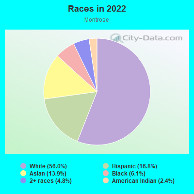
- 16,46856.0%White
- 4,94716.8%Hispanic or Latino
- 4,08313.9%Asian
- 1,7846.1%Black
- 1,4084.8%Two or more races
- 6952.4%American Indian
Median household income in 2022:
| Montrose: | $147,345 |
| Houston: | $60,426 |
Distribution of median household income
![Distribution of median household income]()
- 946Less than $10,000
- 2,514$10,000 to $19,999
- 1,661$20,000 to $29,999
- 1,428$30,000 to $39,999
- 1,012$40,000 to $49,999
- 1,429$50,000 to $59,999
- 2,061$60,000 to $74,999
- 1,952$75,000 to $99,999
- 1,562$100,000 to $124,999
- 2,330$125,000 to $149,999
- 1,767$150,000 to $199,999
- 3,408$200,000 or more

Distribution of owner-occupied house/condo value
![Distribution of owner-occupied house/condo value]()
- 131$150,000 to $199,999
- 229$200,000 to $249,999
- 373$250,000 to $299,999
- 356$300,000 to $399,999
- 611$400,000 to $499,999
- 2,108$500,000 to $749,999
- 811$750,000 to $999,999
- 4,502$1,000,000 or more

Distribution of rent paid by renters
![Distribution of rent paid by renters]()
- 170$500 to $599
- 1,052$600 to $699
- 2,124$700 to $799
- 1,037$800 to $899
- 574$900 to $999
- 2,299$1,000 to $1,249
- 2,149$1,250 to $1,499
- 5,404$1,500 to $1,999
- 3,148$2,000 or more

| Males: | 15,038 |
| Females: | 13,172 |
Males:
| This neighborhood: | 39.1 years |
| Whole city: | 34.4 years |
| This neighborhood: | 44.3 years |
| Whole city: | 34.7 years |
Average household size:
| Montrose: | 1.9 people |
| Houston: | 2.4 people |
Percentage of family households:
| Montrose: | 31.4% |
| Houston: | 43.0% |
| Here: | 28.4% |
| Houston: | 34.7% |
Percentage of married-couple families with children (among all households):
| Montrose: | 41.0% |
| Houston: | 23.3% |
Percentage of single-mother households (among all households):
| Montrose: | 16.3% |
| Houston: | 13.9% |
Percentage of never married males 15 years old and over:
Percentage of never married females 15 years old and over:
| Montrose: | 24.3% |
| Houston: | 22.9% |
Percentage of never married females 15 years old and over:
| Montrose: | 22.5% |
| city: | 21.2% |
Percentage of people that speak English not well or not at all:
| Montrose: | 0.1% |
| Houston: | 15.9% |
Percentage of people born in this state:
Percentage of people born in another U.S. state:
Percentage of native residents but born outside the U.S.:
Percentage of foreign born residents:
| Here: | 45.5% |
| Houston: | 51.1% |
Percentage of people born in another U.S. state:
| Montrose: | 31.3% |
| Houston: | 17.7% |
Percentage of native residents but born outside the U.S.:
| Here: | 1.0% |
| city: | 1.8% |
Percentage of foreign born residents:
| Here: | 22.2% |
| Houston: | 29.4% |
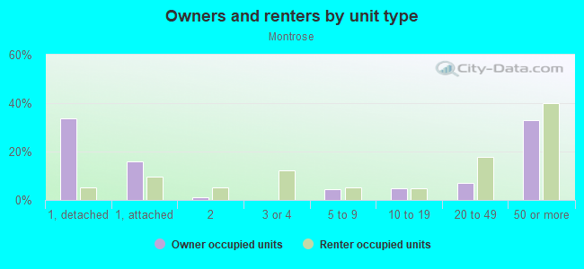
Owner-occupied
Renter-occupied

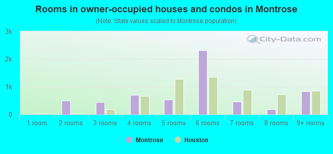
- Rooms in owner-occupied houses and condos in Montrose
- 01 room
- 5002 rooms
- 4523 rooms
- 7114 rooms
- 5305 rooms
- 2,3236 rooms
- 4697 rooms
- 1888 rooms
- 8429+ rooms
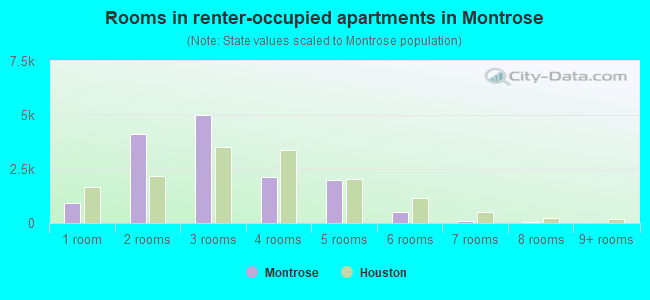
- Rooms in renter-occupied apartments in Montrose
- 9371 room
- 4,1152 rooms
- 4,9873 rooms
- 2,1224 rooms
- 2,0055 rooms
- 5286 rooms
- 1007 rooms
- 258 rooms
- 09+ rooms
Owner-occupied
Renter-occupied
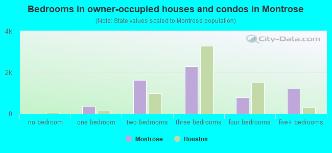
- Bedrooms in owner-occupied houses and condos in Montrose
- 0no bedroom
- 3701 bedroom
- 1,6382 bedrooms
- 2,3013 bedrooms
- 7824 bedrooms
- 1,2015+ bedrooms
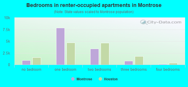
- Bedrooms in renter-occupied apartments in Montrose
- 937no bedroom
- 7,8701 bedroom
- 3,3782 bedrooms
- 7953 bedrooms
- 1004 bedrooms
- 05+ bedrooms
Average number of cars or other vehicles available in houses/condos:
Average number of cars or other vehicles available in apartments:
| This neighborhood: | 1.9 |
| Houston: | 2.0 |
Average number of cars or other vehicles available in apartments:
| Here: | |
| city: |
Percentage of units with a mortgage:
| Montrose: | 52.3% |
| Houston: | 50.8% |
Housing prices:
- Average estimated value of detached houses in 2022 (13.6% of all units):
Montrose: $785,724 Houston: $368,067
- Average estimated value of townhouses or other attached units in 2022 (9.6% of all units):
This neighborhood: $542,812 city: $305,313
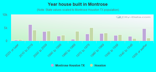
- Year house built in Montrose
- 3682020 or later
- 6,2732010 to 2019
- 3,5502000 to 2009
- 1,8611990 to 1999
- 6251980 to 1989
- 2,6591970 to 1979
- 2,8581960 to 1969
- 2,1301950 to 1959
- 1,7561940 to 1949
- 4,6841939 or earlier
City-data.com crime index for city in 2020 (higher means more crime):
| City: | 560.9 |
| U.S. average: | 219.5 |
Travel time to work (commute)
![Travel time to work (commute)]()
- 230Less than 5 minutes
- 1,5545 to 9 minutes
- 1,64910 to 14 minutes
- 3,24615 to 19 minutes
- 2,49820 to 24 minutes
- 1,24725 to 29 minutes
- 1,44130 to 34 minutes
- 99735 to 39 minutes
- 28540 to 44 minutes
- 82745 to 59 minutes
- 25360 to 89 minutes
- 40290 or more minutes

Means of transportation to work
![Means of transportation to work]()
- 80.9%15,062Drove a car alone
- 3.1%568Carpooled
- 0.8%157Bus
- 0.9%166Taxi
- 3.2%604Bicycle
- 7.7%1,433Walked
- 0.4%82Other means
- 11.6%2,167Worked at home

Time leaving home to go to work
![Time leaving home to go to work]()
- 4612:00 a.m. to 4:59 a.m.
- 3155:00 a.m. to 5:29 a.m.
- 1545:30 a.m. to 5:59 a.m.
- 5876:00 a.m. to 6:29 a.m.
- 1,6096:30 a.m. to 6:59 a.m.
- 2,4367:00 a.m. to 7:29 a.m.
- 2,1847:30 a.m. to 7:59 a.m.
- 1,6638:00 a.m. to 8:29 a.m.
- 1,0898:30 a.m. to 8:59 a.m.
- 1,9799:00 a.m. to 9:59 a.m.
- 1,15810:00 a.m. to 10:59 a.m.
- 19511:00 a.m. to 11:59 a.m.
- 1,41512:00 p.m. to 3:59 p.m.
- 4894:00 p.m. to 11:59 p.m.

Occupations of males:
- Percentage of males in management occupations (except farmers):
Here: 14.1% city: 10.6%
- Percentage of males in business and financial operations occupations:
Here: 7.3% city: 5.4%
- Percentage of males in computer and mathematical occupations:
Here: 5.8% city: 3.9%
- Percentage of males in architecture and engineering occupations:
Here: 7.4% city: 4.0%
- Percentage of males in life, physical, and social science occupations:
Here: 4.8% city: 1.5%
- Percentage of males in legal occupations:
Here: 4.4% city: 1.4%
- Percentage of males in education, training, and library occupations:
Here: 11.7% city: 3.1%
- Percentage of males in arts, design, entertainment, sports, and media occupations:
Here: 4.3% city: 1.6%
- Percentage of males in healthcare practitioners and technical occupations:
Here: 15.8% city: 2.7%
- Percentage of males in service occupations:
Here: 1.8% city: 12.9%
- Percentage of males in sales and office occupations:
Here: 20.0% city: 13.5%
Occupations of females:
- Percentage of females in management occupations (except farmers):
Here: 10.2% city: 8.6%
- Percentage of females in business and financial operations occupations:
Here: 7.4% city: 6.8%
- Percentage of females in architecture and engineering occupations:
Here: 1.7% city: 1.4%
- Percentage of females in life, physical, and social science occupations:
Here: 4.4% city: 1.4%
- Percentage of females in community and social services occupations:
Here: 4.6% city: 1.8%
- Percentage of females in legal occupations:
Here: 2.0% city: 2.0%
- Percentage of females in education, training, and library occupations:
Here: 10.1% city: 8.5%
- Percentage of females in arts, design, entertainment, sports, and media occupations:
Here: 11.1% city: 2.0%
- Percentage of females in healthcare practitioners and technical occupations:
Here: 17.8% city: 8.1%
- Percentage of females in service occupations:
Here: 7.3% city: 23.8%
- Percentage of females in sales and office occupations:
Here: 21.9% city: 26.6%
Percentage of people 16-64 in Armed Forces:
| Montrose: | 0.0% |
| Houston: | 0.1% |
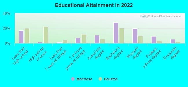
Education in this neighborhood (subdivision or community):
- Percentage of people 3 years and older in K-12 schools:
Montrose: 22.6% Houston: 16.6%
- Percentage of people 3 years and older in undergraduate colleges:
Montrose: 10.0% Houston: 4.6%
- Percentage of people 3 years and older in grad. or professional schools:
Montrose: 6.0% Houston: 1.6%
- Percentage of students K-12 enrolled in private schools:
Montrose: 18.7% Houston: 9.0%
Percentage of population below poverty level:
| Montrose: | 9.5% |
| Houston: | 20.7% |
Median year owner moved in (as recorded in 2022):
| Montrose: | 2009 |
| Houston: | 2010 |
Percentage of married-couple families with both working:
| Montrose: | 93.6% |
| Houston: | 54.9% |
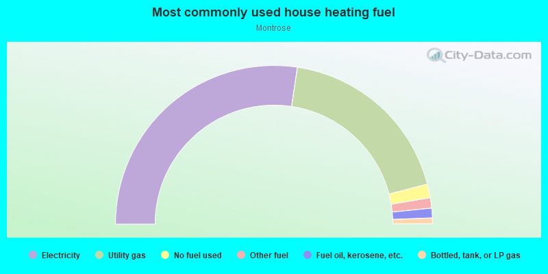
- 54.8%Electricity
- 37.2%Utility gas
- 2.8%No fuel used
- 2.1%Other fuel
- 2.0%Fuel oil, kerosene, etc.
- 1.2%Bottled, tank, or LP gas
Highways in this neighborhood:
US Hwy 59 (Southwest Fwy)
Length: 2.42 miles
Directions: E-W, SW-NE
Address range: 1320 to 1330
Directions: E-W, SW-NE
Address range: 1320 to 1330
State Spur 527
Length: 1.35 miles
Directions: E-W, N-S, SW-NE
Address range: 3900 to 4199
Directions: E-W, N-S, SW-NE
Address range: 3900 to 4199
Roads and streets:
Montrose Blvd
Length: 2.23 miles
Directions: N-S, SE-NW
Address range: 592 to 4599
Directions: N-S, SE-NW
Address range: 592 to 4599
Stanford St
Length: 1.98 miles
Directions: N-S, SE-NW, SW-NE
Address range: 500 to 4599
Directions: N-S, SE-NW, SW-NE
Address range: 500 to 4599
Dunlavy St
Length: 1.95 miles
Directions: N-S, SW-NE
Address range: 700 to 4731
Directions: N-S, SW-NE
Address range: 700 to 4731
Westheimer Rd
Length: 1.74 miles
Directions: E-W, SW-NE
Address range: 200 to 2001
Directions: E-W, SW-NE
Address range: 200 to 2001
W Alabama St
Length: 1.72 miles
Direction: E-W
Address range: 100 to 1898
Direction: E-W
Address range: 100 to 1898
Fairview St
Length: 1.70 miles
Directions: E-W, SE-NW, SW-NE
Address range: 100 to 1999
Directions: E-W, SE-NW, SW-NE
Address range: 100 to 1999
Marshall St
Length: 1.70 miles
Directions: E-W, SW-NE
Address range: 200 to 1999
Directions: E-W, SW-NE
Address range: 200 to 1999
Allen Pkwy
Length: 1.68 miles
Directions: E-W, N-S, SE-NW, SW-NE
Address range: 1901 to 3985
Directions: E-W, N-S, SE-NW, SW-NE
Address range: 1901 to 3985
Woodhead St
Length: 1.68 miles
Direction: N-S
Address range: 1301 to 4719
Direction: N-S
Address range: 1301 to 4719
Welch St
Length: 1.64 miles
Directions: E-W, N-S, SE-NW, SW-NE
Address range: 100 to 1976
Directions: E-W, N-S, SE-NW, SW-NE
Address range: 100 to 1976
W Clay St
Length: 1.56 miles
Direction: E-W
Address range: 300 to 3899
Direction: E-W
Address range: 300 to 3899
Hawthorne St
Length: 1.56 miles
Direction: E-W
Address range: 100 to 1799
Direction: E-W
Address range: 100 to 1799
W Gray St
Length: 1.55 miles
Directions: E-W, SE-NW
Address range: 242 to 1949
Directions: E-W, SE-NW
Address range: 242 to 1949
Richmond Ave
Length: 1.53 miles
Direction: E-W
Address range: 500 to 1899
Direction: E-W
Address range: 500 to 1899
Hazard St
Length: 1.49 miles
Directions: N-S, SW-NE
Address range: 1500 to 4715
Directions: N-S, SW-NE
Address range: 1500 to 4715
Sul Ross St
Length: 1.46 miles
Direction: E-W
Address range: 300 to 1899
Direction: E-W
Address range: 300 to 1899
Harold St
Length: 1.41 miles
Direction: E-W
Address range: 600 to 1899
Direction: E-W
Address range: 600 to 1899
Kipling St
Length: 1.41 miles
Direction: E-W
Address range: 600 to 1899
Direction: E-W
Address range: 600 to 1899
Colquitt St
Length: 1.41 miles
Directions: E-W, N-S
Address range: 400 to 1899
Directions: E-W, N-S
Address range: 400 to 1899
W Main St
Length: 1.40 miles
Directions: E-W, SE-NW
Address range: 300 to 1899
Directions: E-W, SE-NW
Address range: 300 to 1899
Branard St
Length: 1.38 miles
Direction: E-W
Address range: 300 to 1899
Direction: E-W
Address range: 300 to 1899
Taft St
Length: 1.30 miles
Direction: N-S
Address range: 501 to 3399
Direction: N-S
Address range: 501 to 3399
Peden St
Length: 1.30 miles
Direction: E-W
Address range: 300 to 1971
Direction: E-W
Address range: 300 to 1971
Waugh Dr
Length: 1.30 miles
Directions: N-S, SE-NW
Address range: 400 to 2799
Directions: N-S, SE-NW
Address range: 400 to 2799
W Dallas Ave (W Dallas St)
Length: 1.27 miles
Direction: E-W
Address range: 1676 to 3499
Direction: E-W
Address range: 1676 to 3499
Yupon St
Length: 1.23 miles
Directions: E-W, N-S, SE-NW
Address range: 2000 to 4627
Directions: E-W, N-S, SE-NW
Address range: 2000 to 4627
Yoakum Blvd
Length: 1.11 miles
Directions: N-S, SW-NE
Address range: 2400 to 4599
Directions: N-S, SW-NE
Address range: 2400 to 4599
Driscoll St
Length: 1.10 miles
Direction: N-S
Address range: 1500 to 4299
Direction: N-S
Address range: 1500 to 4299
Mandell St
Length: 1.01 miles
Directions: N-S, SE-NW, SW-NE
Address range: 2400 to 4725
Directions: N-S, SE-NW, SW-NE
Address range: 2400 to 4725
Hyde Park Blvd
Length: 0.97 miles
Directions: E-W, N-S, SE-NW, SW-NE
Address range: 1 to 1599
Directions: E-W, N-S, SE-NW, SW-NE
Address range: 1 to 1599
Willard St
Length: 0.89 miles
Direction: E-W
Address range: 100 to 1399
Direction: E-W
Address range: 100 to 1399
Mount Vernon St
Length: 0.89 miles
Direction: N-S
Address range: 3200 to 4627
Direction: N-S
Address range: 3200 to 4627
Graustark St
Length: 0.86 miles
Directions: N-S, SE-NW
Address range: 3300 to 4629
Directions: N-S, SE-NW
Address range: 3300 to 4629
W Drew St
Length: 0.86 miles
Directions: E-W, N-S, SE-NW, SW-NE
Address range: 100 to 1299
Directions: E-W, N-S, SE-NW, SW-NE
Address range: 100 to 1299
Indiana St
Length: 0.85 miles
Directions: E-W, SE-NW, SW-NE
Address range: 1400 to 1999
Directions: E-W, SE-NW, SW-NE
Address range: 1400 to 1999
W Bell St
Length: 0.82 miles
Direction: E-W
Address range: 300 to 1999
Direction: E-W
Address range: 300 to 1999
Crocker St
Length: 0.81 miles
Directions: E-W, N-S, SE-NW
Address range: 1000 to 2799
Directions: E-W, N-S, SE-NW
Address range: 1000 to 2799
Bomar St
Length: 0.81 miles
Direction: E-W
Address range: 300 to 1399
Direction: E-W
Address range: 300 to 1399
Missouri St
Length: 0.79 miles
Directions: E-W, SW-NE
Address range: 1000 to 1999
Directions: E-W, SW-NE
Address range: 1000 to 1999
Roseland St
Length: 0.78 miles
Direction: N-S
Address range: 3300 to 4599
Direction: N-S
Address range: 3300 to 4599
Mason St
Length: 0.77 miles
Directions: N-S, SW-NE
Address range: 1300 to 2899
Directions: N-S, SW-NE
Address range: 1300 to 2899
Commonwealth St
Length: 0.76 miles
Directions: N-S, SE-NW, SW-NE
Address range: 1600 to 2899
Directions: N-S, SE-NW, SW-NE
Address range: 1600 to 2899
Vermont St
Length: 0.73 miles
Directions: E-W, SW-NE
Address range: 1400 to 1968
Directions: E-W, SW-NE
Address range: 1400 to 1968
Haddon St
Length: 0.67 miles
Directions: E-W, N-S, SW-NE
Address range: 1400 to 1971
Directions: E-W, N-S, SW-NE
Address range: 1400 to 1971
Elmen St
Length: 0.66 miles
Direction: N-S
Address range: 1500 to 2599
Direction: N-S
Address range: 1500 to 2599
Park St
Length: 0.66 miles
Direction: N-S
Address range: 1500 to 2599
Direction: N-S
Address range: 1500 to 2599
Morse St
Length: 0.66 miles
Direction: N-S
Address range: 1500 to 2599
Direction: N-S
Address range: 1500 to 2599
Whitney St
Length: 0.63 miles
Direction: N-S
Address range: 1900 to 3399
Direction: N-S
Address range: 1900 to 3399
California St
Length: 0.63 miles
Directions: E-W, N-S, SW-NE
Address range: 1000 to 1899
Directions: E-W, N-S, SW-NE
Address range: 1000 to 1899
Van Buren St
Length: 0.63 miles
Direction: N-S
Address range: 1000 to 2599
Direction: N-S
Address range: 1000 to 2599
Lovett Blvd
Length: 0.61 miles
Directions: E-W, SW-NE
Address range: 400 to 1299
Directions: E-W, SW-NE
Address range: 400 to 1299
Pacific St
Length: 0.60 miles
Directions: E-W, SE-NW, SW-NE
Address range: 100 to 899
Directions: E-W, SE-NW, SW-NE
Address range: 100 to 899
W Pierce St
Length: 0.57 miles
Direction: E-W
Address range: 300 to 1499
Direction: E-W
Address range: 300 to 1499
Garrott St
Length: 0.57 miles
Directions: N-S, SW-NE
Address range: 3400 to 4399
Directions: N-S, SW-NE
Address range: 3400 to 4399
Avondale St
Length: 0.55 miles
Direction: E-W
Address range: 100 to 799
Direction: E-W
Address range: 100 to 799
Genesee St
Length: 0.54 miles
Directions: N-S, SE-NW, SW-NE
Address range: 1000 to 2599
Directions: N-S, SE-NW, SW-NE
Address range: 1000 to 2599
Ridgewood St
Length: 0.54 miles
Directions: E-W, N-S, SE-NW
Address range: 1500 to 2799
Directions: E-W, N-S, SE-NW
Address range: 1500 to 2799
Castle Ct
Length: 0.53 miles
Directions: E-W, N-S, SW-NE
Address range: 1300 to 1699
Directions: E-W, N-S, SW-NE
Address range: 1300 to 1699
Norfolk St
Length: 0.52 miles
Direction: E-W
Address range: 1600 to 1899
Direction: E-W
Address range: 1600 to 1899
Windsor St
Length: 0.52 miles
Direction: SE-NW
Address range: 1900 to 2799
Direction: SE-NW
Address range: 1900 to 2799
Greeley St
Length: 0.51 miles
Directions: N-S, SE-NW, SW-NE
Address range: 3800 to 4729
Directions: N-S, SE-NW, SW-NE
Address range: 3800 to 4729
W Lamar St
Length: 0.49 miles
Directions: E-W, SE-NW
Address range: 1900 to 3499
Directions: E-W, SE-NW
Address range: 1900 to 3499
D Amico St
Length: 0.49 miles
Directions: E-W, N-S, SE-NW
Address range: 3000 to 3599
Directions: E-W, N-S, SE-NW
Address range: 3000 to 3599
Maryland St
Length: 0.48 miles
Directions: E-W, N-S, SW-NE
Address range: 1400 to 1999
Directions: E-W, N-S, SW-NE
Address range: 1400 to 1999
Bonnie Brae St
Length: 0.46 miles
Direction: E-W
Address range: 1200 to 1699
Direction: E-W
Address range: 1200 to 1699
Grant St
Length: 0.45 miles
Directions: E-W, N-S, SE-NW, SW-NE
Address range: 1700 to 2799
Directions: E-W, N-S, SE-NW, SW-NE
Address range: 1700 to 2799
Fargo St
Length: 0.45 miles
Direction: E-W
Address range: 100 to 817
Direction: E-W
Address range: 100 to 817
Mulberry St
Length: 0.43 miles
Direction: N-S
Address range: 3300 to 4099
Direction: N-S
Address range: 3300 to 4099
Hopkins St
Length: 0.42 miles
Directions: N-S, SE-NW
Address range: 1900 to 2699
Directions: N-S, SE-NW
Address range: 1900 to 2699
Jack St
Length: 0.42 miles
Directions: N-S, SW-NE
Address range: 3800 to 4499
Directions: N-S, SW-NE
Address range: 3800 to 4499
Rochow St
Length: 0.39 miles
Directions: N-S, SE-NW
Address range: 500 to 1299
Directions: N-S, SE-NW
Address range: 500 to 1299
Michigan St
Length: 0.39 miles
Directions: E-W, SW-NE
Address range: 1400 to 17406
Directions: E-W, SW-NE
Address range: 1400 to 17406
Stratford St
Length: 0.39 miles
Direction: E-W
Address range: 100 to 499
Direction: E-W
Address range: 100 to 499
Rosine St
Length: 0.38 miles
Direction: N-S
Address range: 500 to 1299
Direction: N-S
Address range: 500 to 1299
Eberhard St
Length: 0.33 miles
Direction: N-S
Address range: 900 to 1599
Direction: N-S
Address range: 900 to 1599
Morgan St
Length: 0.33 miles
Direction: N-S
Address range: 1900 to 2599
Direction: N-S
Address range: 1900 to 2599
Oakley St
Length: 0.33 miles
Directions: E-W, SW-NE
Address range: 500 to 999
Directions: E-W, SW-NE
Address range: 500 to 999
Mc Duffie St
Length: 0.32 miles
Direction: N-S
Address range: 1100 to 2599
Direction: N-S
Address range: 1100 to 2599
Jackson Blvd
Length: 0.31 miles
Directions: E-W, N-S
Address range: 1000 to 1299
Directions: E-W, N-S
Address range: 1000 to 1299
Hyde Park Cres
Length: 0.31 miles
Directions: E-W, N-S, SE-NW, SW-NE
Address range: 1 to 306
Directions: E-W, N-S, SE-NW, SW-NE
Address range: 1 to 306
Nevada St
Length: 0.30 miles
Direction: SW-NE
Address range: 1400 to 1699
Direction: SW-NE
Address range: 1400 to 1699
Woodrow St
Length: 0.29 miles
Direction: E-W
Address range: 600 to 999
Direction: E-W
Address range: 600 to 999
Columbus St
Length: 0.29 miles
Directions: N-S, SW-NE
Address range: 18 to 1599
Directions: N-S, SW-NE
Address range: 18 to 1599
Marconi St
Length: 0.29 miles
Direction: N-S
Address range: 1000 to 1599
Direction: N-S
Address range: 1000 to 1599
W Dallas St
Length: 0.28 miles
Direction: E-W
Address range: 3500 to 35341
Direction: E-W
Address range: 3500 to 35341
Converse St
Length: 0.28 miles
Direction: N-S
Address range: 1900 to 2507
Direction: N-S
Address range: 1900 to 2507
Portsmouth St
Length: 0.27 miles
Direction: E-W
Address range: 1700 to 1899
Direction: E-W
Address range: 1700 to 1899
Lexington St
Length: 0.25 miles
Direction: E-W
Address range: 1700 to 1899
Direction: E-W
Address range: 1700 to 1899
Audubon Pl
Length: 0.24 miles
Direction: N-S
Address range: 3400 to 3799
Direction: N-S
Address range: 3400 to 3799
Flora St
Length: 0.24 miles
Direction: N-S
Address range: 3400 to 3799
Direction: N-S
Address range: 3400 to 3799
Emerson St
Length: 0.24 miles
Direction: E-W
Address range: 200 to 425
Direction: E-W
Address range: 200 to 425
Westmoreland St
Length: 0.24 miles
Direction: E-W
Address range: 200 to 418
Direction: E-W
Address range: 200 to 418
W McKinney St
Length: 0.23 miles
Direction: E-W
Address range: 1900 to 1999
Direction: E-W
Address range: 1900 to 1999
W Saulnier St
Length: 0.22 miles
Direction: E-W
Address range: 300 to 699
Direction: E-W
Address range: 300 to 699
W Polk Ave
Length: 0.22 miles
Direction: E-W
Address range: 300 to 699
Direction: E-W
Address range: 300 to 699
Cherryhurst St
Length: 0.22 miles
Direction: SW-NE
Address range: 1600 to 1899
Direction: SW-NE
Address range: 1600 to 1899
Haver St
Length: 0.22 miles
Direction: SW-NE
Address range: 1600 to 1899
Direction: SW-NE
Address range: 1600 to 1899
Temple Dr
Length: 0.22 miles
Directions: E-W, N-S, SW-NE
Address range: 1900 to 1999
Directions: E-W, N-S, SW-NE
Address range: 1900 to 1999
Marston St
Length: 0.20 miles
Direction: N-S
Address range: 800 to 899
Direction: N-S
Address range: 800 to 899
Hazel St
Length: 0.20 miles
Direction: N-S
Address range: 1300 to 1699
Direction: N-S
Address range: 1300 to 1699
Gross St
Length: 0.19 miles
Direction: N-S
Address range: 1000 to 1599
Direction: N-S
Address range: 1000 to 1599
Joe Annie St
Length: 0.19 miles
Directions: N-S, SW-NE
Address range: 1000 to 1299
Directions: N-S, SW-NE
Address range: 1000 to 1299
Bute St
Length: 0.18 miles
Direction: N-S
Address range: 3800 to 4099
Direction: N-S
Address range: 3800 to 4099
Kenwood Ln
Length: 0.18 miles
Direction: E-W
Address range: 1100 to 1299
Direction: E-W
Address range: 1100 to 1299
W Mc Kinney St
Length: 0.18 miles
Direction: E-W
Address range: 2600 to 2899
Direction: E-W
Address range: 2600 to 2899
Lamar St
Length: 0.17 miles
Direction: E-W
Direction: E-W
Kyle St
Length: 0.16 miles
Direction: N-S
Address range: 4300 to 4599
Direction: N-S
Address range: 4300 to 4599
Ralph St
Length: 0.16 miles
Direction: N-S
Address range: 2400 to 2599
Direction: N-S
Address range: 2400 to 2599
Missouri Pl (Missouri St)
Length: 0.15 miles
Directions: E-W, SE-NW
Address range: 1820 to 1919
Directions: E-W, SE-NW
Address range: 1820 to 1919
Helena St
Length: 0.15 miles
Direction: N-S
Address range: 2923 to 3199
Direction: N-S
Address range: 2923 to 3199
Loretto Dr
Length: 0.15 miles
Direction: N-S
Address range: 4000 to 4299
Direction: N-S
Address range: 4000 to 4299
Leonidas
Length: 0.14 miles
Direction: E-W
Direction: E-W
la Rue St
Length: 0.14 miles
Direction: N-S
Address range: 1000 to 1299
Direction: N-S
Address range: 1000 to 1299
Peveto St
Length: 0.14 miles
Direction: N-S
Address range: 1000 to 1299
Direction: N-S
Address range: 1000 to 1299
Metropolitan
Length: 0.14 miles
Direction: N-S
Direction: N-S
Tirrell St
Length: 0.14 miles
Direction: N-S
Address range: 700 to 848
Direction: N-S
Address range: 700 to 848
Burlington St
Length: 0.13 miles
Directions: N-S, SE-NW, SW-NE
Address range: 3400 to 3699
Directions: N-S, SE-NW, SW-NE
Address range: 3400 to 3699
Brandt St
Length: 0.12 miles
Direction: N-S
Address range: 3800 to 3999
Direction: N-S
Address range: 3800 to 3999
Baldwin St
Length: 0.12 miles
Directions: E-W, N-S
Address range: 2903 to 3099
Directions: E-W, N-S
Address range: 2903 to 3099
W Webster St
Length: 0.12 miles
Direction: E-W
Address range: 1700 to 1899
Direction: E-W
Address range: 1700 to 1899
O Neil St
Length: 0.12 miles
Direction: E-W
Address range: 1700 to 1899
Direction: E-W
Address range: 1700 to 1899
Andrews St
Length: 0.12 miles
Direction: E-W
Address range: 1700 to 1899
Direction: E-W
Address range: 1700 to 1899
Entrance 2 Dr
Length: 0.12 miles
Directions: N-S, SE-NW, SW-NE
Directions: N-S, SE-NW, SW-NE
Lincoln St
Length: 0.11 miles
Direction: N-S
Address range: 2600 to 2799
Direction: N-S
Address range: 2600 to 2799
Rylis St
Length: 0.11 miles
Directions: N-S, SW-NE
Directions: N-S, SW-NE
Buffalo Ter
Length: 0.11 miles
Direction: E-W
Address range: 2000 to 2099
Direction: E-W
Address range: 2000 to 2099
Rhode Pl
Length: 0.11 miles
Direction: N-S
Address range: 800 to 999
Direction: N-S
Address range: 800 to 999
Cleveland St
Length: 0.11 miles
Directions: E-W, N-S
Address range: 1700 to 1899
Directions: E-W, N-S
Address range: 1700 to 1899
W Walker Ave
Length: 0.11 miles
Directions: E-W, SE-NW
Address range: 1900 to 1999
Directions: E-W, SE-NW
Address range: 1900 to 1999
Damon Ct
Length: 0.09 miles
Directions: E-W, SE-NW, SW-NE
Address range: 800 to 999
Directions: E-W, SE-NW, SW-NE
Address range: 800 to 999
Wauchcrest
Length: 0.09 miles
Direction: SE-NW
Address range: 2700 to 2799
Direction: SE-NW
Address range: 2700 to 2799
Vick St
Length: 0.09 miles
Direction: E-W
Address range: 3200 to 3399
Direction: E-W
Address range: 3200 to 3399
Newhouse St
Length: 0.08 miles
Direction: E-W
Address range: 3700 to 3819
Direction: E-W
Address range: 3700 to 3819
Alpha St
Length: 0.08 miles
Direction: E-W
Address range: 3600 to 3699
Direction: E-W
Address range: 3600 to 3699
Pierce
Length: 0.08 miles
Directions: E-W, SE-NW
Directions: E-W, SE-NW
Bell
Length: 0.08 miles
Directions: E-W, SW-NE
Directions: E-W, SW-NE
Castle Court Pl
Length: 0.08 miles
Directions: E-W, N-S, SE-NW
Address range: 4400 to 4469
Directions: E-W, N-S, SE-NW
Address range: 4400 to 4469
Kueter
Length: 0.08 miles
Directions: E-W, N-S
Address range: 2500 to 2599
Directions: E-W, N-S
Address range: 2500 to 2599
Wilkenson St
Length: 0.08 miles
Directions: N-S, SE-NW, SW-NE
Address range: 800 to 999
Directions: N-S, SE-NW, SW-NE
Address range: 800 to 999
Miramar St
Length: 0.07 miles
Direction: E-W
Address range: 1200 to 1299
Direction: E-W
Address range: 1200 to 1299
Robita St
Length: 0.07 miles
Direction: N-S
Address range: 1 to 99
Direction: N-S
Address range: 1 to 99
Rylis
Length: 0.06 miles
Directions: E-W, N-S
Directions: E-W, N-S
Ruthven St
Length: 0.06 miles
Direction: E-W
Address range: 1700 to 1799
Direction: E-W
Address range: 1700 to 1799
Victor St
Length: 0.06 miles
Direction: E-W
Address range: 1700 to 1799
Direction: E-W
Address range: 1700 to 1799
Upas
Length: 0.05 miles
Direction: N-S
Address range: 2400 to 2499
Direction: N-S
Address range: 2400 to 2499
Milam (State Spur 527)
Length: 0.05 miles
Direction: SW-NE
Direction: SW-NE
Elsbury St
Length: 0.05 miles
Directions: N-S, SW-NE
Address range: 4300 to 4399
Directions: N-S, SW-NE
Address range: 4300 to 4399
Peveto
Length: 0.05 miles
Direction: N-S
Direction: N-S
W McKinney St (W McKinney Dr)
Length: 0.05 miles
Direction: E-W
Address range: 2000 to 2099
Direction: E-W
Address range: 2000 to 2099
Greenwich Terrace Dr (Sweetwood Dr)
Length: 0.04 miles
Direction: E-W
Address range: 3500 to 3599
Direction: E-W
Address range: 3500 to 3599
Rosine
Length: 0.04 miles
Directions: N-S, SE-NW, SW-NE
Directions: N-S, SE-NW, SW-NE
Buel Ct
Length: 0.04 miles
Direction: N-S
Address range: 1 to 1899
Direction: N-S
Address range: 1 to 1899
Victor Aly
Length: 0.04 miles
Direction: N-S
Address range: 1700 to 1799
Direction: N-S
Address range: 1700 to 1799
Leonidas St
Length: 0.04 miles
Direction: E-W
Address range: 3200 to 3499
Direction: E-W
Address range: 3200 to 3499
Pacific
Length: 0.02 miles
Direction: E-W
Direction: E-W
Railroad features:
Southern Pacific RR
Length: 0.01 miles
Direction: N-S
Direction: N-S