Myerland neighborhood in Houston, Texas (TX), 77096, 77035 detailed profile
Settings
X


Business Search - 14 Million verified businesses
Area: 4.637 square miles
Population: 23,036
Population density:
| Myerland: | 4,967 people per square mile |
| Houston: | 3,977 people per square mile |

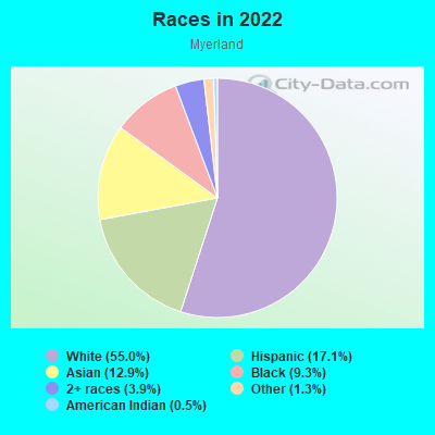
- 13,52755.0%White
- 4,20217.1%Hispanic or Latino
- 3,17312.9%Asian
- 2,3009.3%Black
- 9493.9%Two or more races
- 3121.3%Some other race
- 1290.5%American Indian
- 190.08%Native Hawaiian and Other
Pacific Islander

Distribution of median household income
![Distribution of median household income]()
- 981Less than $10,000
- 751$10,000 to $19,999
- 1,103$20,000 to $29,999
- 879$30,000 to $39,999
- 604$40,000 to $49,999
- 723$50,000 to $59,999
- 638$60,000 to $74,999
- 712$75,000 to $99,999
- 815$100,000 to $124,999
- 544$125,000 to $149,999
- 1,090$150,000 to $199,999
- 3,124$200,000 or more

Distribution of owner-occupied house/condo value
![Distribution of owner-occupied house/condo value]()
- 1,602Less than $50,000
- 2,709$50,000 to $99,999
- 644$100,000 to $149,999
- 795$150,000 to $199,999
- 358$200,000 to $249,999
- 732$250,000 to $299,999
- 1,600$300,000 to $399,999
- 1,651$400,000 to $499,999
- 1,435$500,000 to $749,999
- 540$750,000 to $999,999
- 2,285$1,000,000 or more

Distribution of rent paid by renters
![Distribution of rent paid by renters]()
- 270$400 to $499
- 1,058$500 to $599
- 475$600 to $699
- 3,527$700 to $799
- 2,563$800 to $899
- 694$900 to $999
- 1,205$1,000 to $1,249
- 1,281$1,250 to $1,499
- 666$1,500 to $1,999
- 1,240$2,000 or more

| Males: | 11,170 |
| Females: | 11,865 |
Males:
| This neighborhood: | 40.0 years |
| Whole city: | 34.4 years |
| This neighborhood: | 44.0 years |
| Whole city: | 34.7 years |
Average household size:
| Myerland: | 5.5 people |
| Houston: | 2.4 people |
Percentage of family households:
| Myerland: | 55.2% |
| Houston: | 43.0% |
| Here: | 66.5% |
| Houston: | 34.7% |
Percentage of married-couple families with children (among all households):
| Myerland: | 30.2% |
| Houston: | 23.3% |
Percentage of single-mother households (among all households):
| Myerland: | 6.2% |
| Houston: | 13.9% |
Percentage of never married males 15 years old and over:
Percentage of never married females 15 years old and over:
| Myerland: | 12.1% |
| Houston: | 22.9% |
Percentage of never married females 15 years old and over:
| Myerland: | 12.0% |
| city: | 21.2% |
Percentage of people that speak English not well or not at all:
| Myerland: | 4.8% |
| Houston: | 15.9% |
Percentage of people born in this state:
Percentage of people born in another U.S. state:
Percentage of native residents but born outside the U.S.:
Percentage of foreign born residents:
| Here: | 48.2% |
| Houston: | 51.1% |
Percentage of people born in another U.S. state:
| Myerland: | 25.1% |
| Houston: | 17.7% |
Percentage of native residents but born outside the U.S.:
| Here: | 4.6% |
| city: | 1.8% |
Percentage of foreign born residents:
| Here: | 22.1% |
| Houston: | 29.4% |
Owner-occupied
Renter-occupied

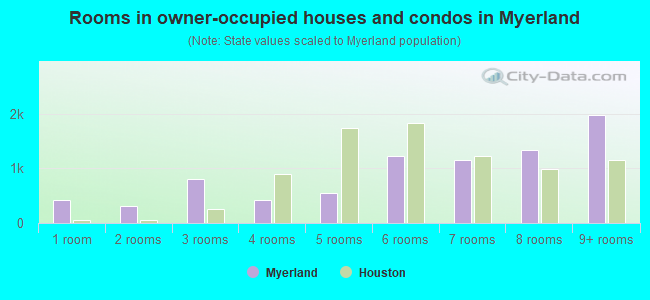
- Rooms in owner-occupied houses and condos in Myerland
- 4231 room
- 3082 rooms
- 8063 rooms
- 4194 rooms
- 5435 rooms
- 1,2266 rooms
- 1,1597 rooms
- 1,3458 rooms
- 1,9789+ rooms
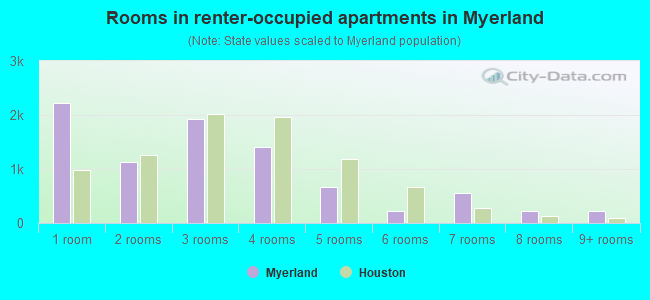
- Rooms in renter-occupied apartments in Myerland
- 2,2131 room
- 1,1322 rooms
- 1,9333 rooms
- 1,4114 rooms
- 6655 rooms
- 2286 rooms
- 5497 rooms
- 2308 rooms
- 2279+ rooms
Owner-occupied
Renter-occupied

- Bedrooms in owner-occupied houses and condos in Myerland
- 423no bedroom
- 6791 bedroom
- 3732 bedrooms
- 3,2123 bedrooms
- 2,4554 bedrooms
- 6865+ bedrooms
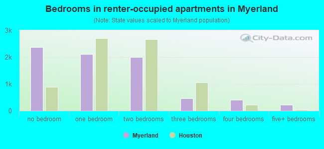
- Bedrooms in renter-occupied apartments in Myerland
- 2,377no bedroom
- 2,1101 bedroom
- 2,0002 bedrooms
- 4673 bedrooms
- 4094 bedrooms
- 2225+ bedrooms
Average number of cars or other vehicles available in houses/condos:
Average number of cars or other vehicles available in apartments:
| This neighborhood: | 2.3 |
| Houston: | 2.0 |
Average number of cars or other vehicles available in apartments:
| Here: | |
| city: |
Percentage of units with a mortgage:
| Myerland: | 54.6% |
| Houston: | 50.8% |
Average estimated value of detached houses in 2022 (84.9% of all units):
| Myerland: | $530,024 |
| Houston: | $368,067 |
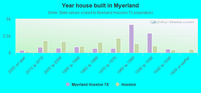
- Year house built in Myerland
- 3832020 or later
- 8052010 to 2019
- 6742000 to 2009
- 8561990 to 1999
- 6301980 to 1989
- 6521970 to 1979
- 4,1911960 to 1969
- 2,8851950 to 1959
- 5291940 to 1949
- 01939 or earlier
City-data.com crime index for city in 2020 (higher means more crime):
| City: | 560.9 |
| U.S. average: | 219.5 |
Travel time to work (commute)
![Travel time to work (commute)]()
- 58Less than 5 minutes
- 2285 to 9 minutes
- 77310 to 14 minutes
- 1,15515 to 19 minutes
- 1,18820 to 24 minutes
- 59525 to 29 minutes
- 1,56230 to 34 minutes
- 43935 to 39 minutes
- 29140 to 44 minutes
- 75945 to 59 minutes
- 38060 to 89 minutes
- 9590 or more minutes

Means of transportation to work
![Means of transportation to work]()
- 64.6%7,011Drove a car alone
- 8.6%934Carpooled
- 6.2%673Bus
- 3.8%408Subway or elevated rail
- 1.7%182Taxi
- 1.8%196Motorcycle
- 1.8%192Bicycle
- 1.2%127Walked
- 6.6%721Other means
- 22.5%2,440Worked at home

Time leaving home to go to work
![Time leaving home to go to work]()
- 19412:00 a.m. to 4:59 a.m.
- 2435:00 a.m. to 5:29 a.m.
- 2715:30 a.m. to 5:59 a.m.
- 6276:00 a.m. to 6:29 a.m.
- 7816:30 a.m. to 6:59 a.m.
- 1,2727:00 a.m. to 7:29 a.m.
- 9667:30 a.m. to 7:59 a.m.
- 1,0888:00 a.m. to 8:29 a.m.
- 6178:30 a.m. to 8:59 a.m.
- 6229:00 a.m. to 9:59 a.m.
- 27610:00 a.m. to 10:59 a.m.
- 10311:00 a.m. to 11:59 a.m.
- 28512:00 p.m. to 3:59 p.m.
- 1654:00 p.m. to 11:59 p.m.

Occupations of males:
- Percentage of males in management occupations (except farmers):
Here: 17.8% city: 10.6%
- Percentage of males in business and financial operations occupations:
Here: 11.9% city: 5.4%
- Percentage of males in computer and mathematical occupations:
Here: 6.7% city: 3.9%
- Percentage of males in architecture and engineering occupations:
Here: 7.0% city: 4.0%
- Percentage of males in life, physical, and social science occupations:
Here: 2.0% city: 1.5%
- Percentage of males in legal occupations:
Here: 4.0% city: 1.4%
- Percentage of males in education, training, and library occupations:
Here: 5.3% city: 3.1%
- Percentage of males in arts, design, entertainment, sports, and media occupations:
Here: 2.6% city: 1.6%
- Percentage of males in healthcare practitioners and technical occupations:
Here: 6.7% city: 2.7%
- Percentage of males in service occupations:
Here: 5.0% city: 12.9%
- Percentage of males in sales and office occupations:
Here: 16.7% city: 13.5%
- Percentage of males in construction, extraction, and maintenance occupations:
Here: 5.3% city: 15.7%
- Percentage of males in transportation occupations:
Here: 2.9% city: 6.1%
- Percentage of males in material moving occupations:
Here: 1.5% city: 5.4%
Occupations of females:
- Percentage of females in management occupations (except farmers):
Here: 12.8% city: 8.6%
- Percentage of females in business and financial operations occupations:
Here: 10.9% city: 6.8%
- Percentage of females in computer and mathematical occupations:
Here: 2.9% city: 1.7%
- Percentage of females in architecture and engineering occupations:
Here: 3.2% city: 1.4%
- Percentage of females in life, physical, and social science occupations:
Here: 2.4% city: 1.4%
- Percentage of females in community and social services occupations:
Here: 2.5% city: 1.8%
- Percentage of females in legal occupations:
Here: 3.7% city: 2.0%
- Percentage of females in education, training, and library occupations:
Here: 12.7% city: 8.5%
- Percentage of females in arts, design, entertainment, sports, and media occupations:
Here: 2.9% city: 2.0%
- Percentage of females in healthcare practitioners and technical occupations:
Here: 13.4% city: 8.1%
- Percentage of females in service occupations:
Here: 10.8% city: 23.8%
- Percentage of females in sales and office occupations:
Here: 19.8% city: 26.6%
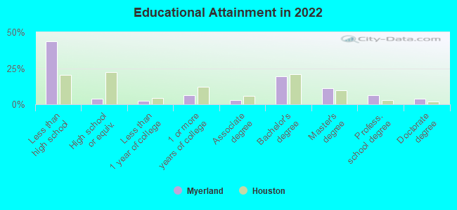
Education in this neighborhood (subdivision or community):
- Percentage of people 3 years and older in K-12 schools:
Myerland: 22.5% Houston: 16.6%
- Percentage of people 3 years and older in undergraduate colleges:
Myerland: 7.5% Houston: 4.6%
- Percentage of people 3 years and older in grad. or professional schools:
Myerland: 3.3% Houston: 1.6%
- Percentage of students K-12 enrolled in private schools:
Myerland: 70.4% Houston: 9.0%
Percentage of population below poverty level:
| Myerland: | 11.1% |
| Houston: | 20.7% |
Median year owner moved in (as recorded in 2022):
| Myerland: | 2007 |
| Houston: | 2010 |
Percentage of married-couple families with both working:
| Myerland: | 79.3% |
| Houston: | 54.9% |
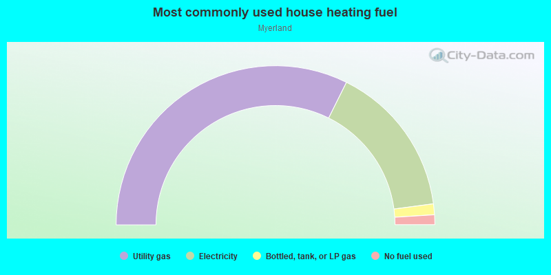
- 64.7%Utility gas
- 31.1%Electricity
- 2.2%Bottled, tank, or LP gas
- 2.0%No fuel used
Limited-access highways (interstate or state) in this neighborhood:
W Loop Fwy (I- 610)
Length: 1.99 miles
Directions: E-W, N-S, SE-NW
Directions: E-W, N-S, SE-NW
Roads and streets:
Chimney Rock Rd
Length: 3.30 miles
Direction: N-S
Address range: 8450 to 10599
Direction: N-S
Address range: 8450 to 10599
S Braeswood Blvd
Length: 3.13 miles
Directions: E-W, SE-NW
Address range: 4800 to 6299
Directions: E-W, SE-NW
Address range: 4800 to 6299
Yarwell Dr
Length: 2.88 miles
Directions: E-W, SE-NW, SW-NE
Address range: 4900 to 6299
Directions: E-W, SE-NW, SW-NE
Address range: 4900 to 6299
Beechnut St
Length: 2.79 miles
Direction: E-W
Address range: 4400 to 5671
Direction: E-W
Address range: 4400 to 5671
N Braeswood Blvd
Length: 2.76 miles
Directions: E-W, SE-NW, SW-NE
Address range: 4438 to 5698
Directions: E-W, SE-NW, SW-NE
Address range: 4438 to 5698
Dumfries Dr
Length: 2.75 miles
Directions: E-W, N-S, SE-NW, SW-NE
Address range: 4900 to 6299
Directions: E-W, N-S, SE-NW, SW-NE
Address range: 4900 to 6299
S Post Oak Rd
Length: 2.72 miles
Directions: N-S, SW-NE
Address range: 9600 to 10799
Directions: N-S, SW-NE
Address range: 9600 to 10799
Wigton Dr
Length: 2.68 miles
Directions: E-W, SW-NE
Address range: 4900 to 6299
Directions: E-W, SW-NE
Address range: 4900 to 6299
Rutherglenn Dr
Length: 2.46 miles
Directions: E-W, N-S, SW-NE
Address range: 5100 to 6299
Directions: E-W, N-S, SW-NE
Address range: 5100 to 6299
Valkeith Dr
Length: 2.38 miles
Directions: E-W, N-S, SW-NE
Address range: 4900 to 6199
Directions: E-W, N-S, SW-NE
Address range: 4900 to 6199
Cheena Dr
Length: 2.33 miles
Directions: E-W, N-S, SW-NE
Address range: 4900 to 6242
Directions: E-W, N-S, SW-NE
Address range: 4900 to 6242
Jason St
Length: 2.32 miles
Directions: E-W, SE-NW, SW-NE
Address range: 4600 to 5699
Directions: E-W, SE-NW, SW-NE
Address range: 4600 to 5699
S Rice Ave
Length: 2.26 miles
Directions: N-S, SE-NW, SW-NE
Address range: 8400 to 9799
Directions: N-S, SE-NW, SW-NE
Address range: 8400 to 9799
Braesheather Dr
Length: 2.25 miles
Directions: E-W, N-S, SE-NW
Address range: 4900 to 6299
Directions: E-W, N-S, SE-NW
Address range: 4900 to 6299
Jackwood St
Length: 2.11 miles
Directions: E-W, SW-NE
Address range: 4600 to 5699
Directions: E-W, SW-NE
Address range: 4600 to 5699
Braesvalley Dr
Length: 1.91 miles
Directions: E-W, N-S, SE-NW, SW-NE
Address range: 4700 to 5799
Directions: E-W, N-S, SE-NW, SW-NE
Address range: 4700 to 5799
Indigo St
Length: 1.81 miles
Direction: E-W
Address range: 4600 to 5710
Direction: E-W
Address range: 4600 to 5710
Queensloch Dr
Length: 1.76 miles
Directions: E-W, SE-NW, SW-NE
Address range: 5100 to 6299
Directions: E-W, SE-NW, SW-NE
Address range: 5100 to 6299
Lymbar Dr
Length: 1.59 miles
Directions: E-W, SW-NE
Address range: 5000 to 6299
Directions: E-W, SW-NE
Address range: 5000 to 6299
Willowbend Blvd
Length: 1.54 miles
Directions: E-W, SE-NW
Address range: 4826 to 5699
Directions: E-W, SE-NW
Address range: 4826 to 5699
Mullins Dr
Length: 1.53 miles
Directions: N-S, SE-NW
Address range: 8000 to 10599
Directions: N-S, SE-NW
Address range: 8000 to 10599
Braesmont Dr
Length: 1.51 miles
Direction: N-S
Address range: 8300 to 10499
Direction: N-S
Address range: 8300 to 10499
Darnell St
Length: 1.36 miles
Directions: E-W, N-S, SW-NE
Address range: 5000 to 5699
Directions: E-W, N-S, SW-NE
Address range: 5000 to 5699
Imogene St
Length: 1.27 miles
Directions: E-W, N-S, SE-NW, SW-NE
Address range: 4700 to 5499
Directions: E-W, N-S, SE-NW, SW-NE
Address range: 4700 to 5499
Loch Lomond Dr
Length: 1.23 miles
Direction: E-W
Address range: 4900 to 5599
Direction: E-W
Address range: 4900 to 5599
Paisley Ln (Paisley St)
Length: 1.19 miles
Directions: E-W, N-S, SW-NE
Address range: 5100 to 6299
Directions: E-W, N-S, SW-NE
Address range: 5100 to 6299
Grape Rd (Grape St)
Length: 1.19 miles
Direction: E-W
Address range: 5100 to 5645
Direction: E-W
Address range: 5100 to 5645
Carew St
Length: 1.18 miles
Directions: E-W, N-S, SE-NW
Address range: 5000 to 5699
Directions: E-W, N-S, SE-NW
Address range: 5000 to 5699
W Bellfort St
Length: 1.17 miles
Directions: E-W, SW-NE
Address range: 4601 to 5100
Directions: E-W, SW-NE
Address range: 4601 to 5100
Renwick Dr
Length: 1.14 miles
Directions: N-S, SW-NE
Address range: 8100 to 10599
Directions: N-S, SW-NE
Address range: 8100 to 10599
Birdwood Rd
Length: 1.04 miles
Direction: E-W
Address range: 5100 to 5731
Direction: E-W
Address range: 5100 to 5731
Edith St
Length: 0.99 miles
Directions: E-W, SW-NE
Address range: 5300 to 5641
Directions: E-W, SW-NE
Address range: 5300 to 5641
Manhattan Dr
Length: 0.99 miles
Direction: N-S
Address range: 8500 to 10799
Direction: N-S
Address range: 8500 to 10799
Pontiac Dr
Length: 0.91 miles
Directions: N-S, SE-NW, SW-NE
Address range: 8200 to 9299
Directions: N-S, SE-NW, SW-NE
Address range: 8200 to 9299
Glenmeadow Dr
Length: 0.79 miles
Directions: E-W, N-S, SE-NW
Address range: 4900 to 5299
Directions: E-W, N-S, SE-NW
Address range: 4900 to 5299
Hillcroft Ave (Hillcroft St)
Length: 0.77 miles
Directions: N-S, SE-NW
Address range: 9300 to 10505
Directions: N-S, SE-NW
Address range: 9300 to 10505
Willowgrove Dr
Length: 0.76 miles
Directions: N-S, SW-NE
Address range: 10000 to 10799
Directions: N-S, SW-NE
Address range: 10000 to 10799
Endicott Ln
Length: 0.75 miles
Directions: N-S, SE-NW, SW-NE
Address range: 8500 to 10699
Directions: N-S, SE-NW, SW-NE
Address range: 8500 to 10699
Ferris Dr
Length: 0.70 miles
Direction: N-S
Address range: 8400 to 9099
Direction: N-S
Address range: 8400 to 9099
Kuldell Dr
Length: 0.70 miles
Directions: E-W, SW-NE
Address range: 5400 to 5765
Directions: E-W, SW-NE
Address range: 5400 to 5765
Ariel St
Length: 0.70 miles
Direction: E-W
Address range: 5200 to 5699
Direction: E-W
Address range: 5200 to 5699
Bob White Dr
Length: 0.64 miles
Direction: N-S
Address range: 9400 to 10499
Direction: N-S
Address range: 9400 to 10499
Cedarhurst Dr
Length: 0.64 miles
Directions: N-S, SW-NE
Address range: 9600 to 10699
Directions: N-S, SW-NE
Address range: 9600 to 10699
Braewick Dr
Length: 0.63 miles
Direction: N-S
Address range: 9400 to 10399
Direction: N-S
Address range: 9400 to 10399
Bayou Bridge Dr
Length: 0.61 miles
Direction: E-W
Address range: 5900 to 6299
Direction: E-W
Address range: 5900 to 6299
Prichett Dr
Length: 0.57 miles
Direction: N-S
Address range: 8500 to 9099
Direction: N-S
Address range: 8500 to 9099
Valerie St
Length: 0.55 miles
Direction: E-W
Address range: 5500 to 6029
Direction: E-W
Address range: 5500 to 6029
Caversham Dr
Length: 0.54 miles
Direction: E-W
Address range: 5200 to 5599
Direction: E-W
Address range: 5200 to 5599
Atwell Dr
Length: 0.53 miles
Direction: N-S
Address range: 9700 to 10599
Direction: N-S
Address range: 9700 to 10599
S Atwell Dr
Length: 0.53 miles
Direction: N-S
Address range: 8400 to 8999
Direction: N-S
Address range: 8400 to 8999
Landsdowne Dr
Length: 0.52 miles
Direction: N-S
Address range: 9000 to 10399
Direction: N-S
Address range: 9000 to 10399
Heatherglen Dr
Length: 0.51 miles
Direction: E-W
Address range: 4900 to 5099
Direction: E-W
Address range: 4900 to 5099
Ashcroft Dr
Length: 0.51 miles
Direction: N-S
Address range: 8000 to 10399
Direction: N-S
Address range: 8000 to 10399
Glenfield Ct
Length: 0.46 miles
Directions: N-S, SE-NW
Address range: 9400 to 10563
Directions: N-S, SE-NW
Address range: 9400 to 10563
Runnymeade Dr
Length: 0.46 miles
Direction: SE-NW
Address range: 9700 to 10399
Direction: SE-NW
Address range: 9700 to 10399
O Meara Dr (Omeara Dr)
Length: 0.45 miles
Directions: E-W, SE-NW, SW-NE
Address range: 4500 to 4899
Directions: E-W, SE-NW, SW-NE
Address range: 4500 to 4899
Balmforth Ln
Length: 0.44 miles
Direction: SE-NW
Address range: 9900 to 10499
Direction: SE-NW
Address range: 9900 to 10499
Moonlight Dr
Length: 0.43 miles
Directions: N-S, SE-NW
Address range: 8500 to 10099
Directions: N-S, SE-NW
Address range: 8500 to 10099
Meyer Park Dr
Length: 0.42 miles
Direction: N-S
Address range: 8500 to 9099
Direction: N-S
Address range: 8500 to 9099
Meyer Forest Dr
Length: 0.42 miles
Directions: N-S, SE-NW, SW-NE
Directions: N-S, SE-NW, SW-NE
Doud Rd
Length: 0.41 miles
Directions: E-W, N-S, SE-NW, SW-NE
Address range: 8900 to 10199
Directions: E-W, N-S, SE-NW, SW-NE
Address range: 8900 to 10199
Albury Dr
Length: 0.41 miles
Direction: N-S
Address range: 9400 to 10599
Direction: N-S
Address range: 9400 to 10599
Frankway Dr
Length: 0.40 miles
Direction: N-S
Address range: 8500 to 9099
Direction: N-S
Address range: 8500 to 9099
Contour Pl
Length: 0.37 miles
Directions: E-W, N-S, SE-NW
Address range: 5000 to 5299
Directions: E-W, N-S, SE-NW
Address range: 5000 to 5299
Willowisp Dr
Length: 0.37 miles
Directions: E-W, N-S
Address range: 10300 to 10799
Directions: E-W, N-S
Address range: 10300 to 10799
Cheltenham Dr
Length: 0.37 miles
Directions: E-W, SE-NW
Address range: 5500 to 5799
Directions: E-W, SE-NW
Address range: 5500 to 5799
Millbury Dr
Length: 0.37 miles
Direction: N-S
Address range: 9400 to 9999
Direction: N-S
Address range: 9400 to 9999
Mc Dermed Dr
Length: 0.36 miles
Directions: E-W, SE-NW
Address range: 4713 to 4899
Directions: E-W, SE-NW
Address range: 4713 to 4899
Waycross St
Length: 0.33 miles
Directions: E-W, SE-NW
Address range: 4800 to 5199
Directions: E-W, SE-NW
Address range: 4800 to 5199
Sylmar Rd
Length: 0.32 miles
Direction: E-W
Address range: 5500 to 5635
Direction: E-W
Address range: 5500 to 5635
Pine St
Length: 0.32 miles
Direction: E-W
Address range: 5578 to 6215
Direction: E-W
Address range: 5578 to 6215
Rampart St
Length: 0.32 miles
Direction: N-S
Address range: 7800 to 8199
Direction: N-S
Address range: 7800 to 8199
Reamer St
Length: 0.31 miles
Directions: E-W, SE-NW
Address range: 5500 to 5799
Directions: E-W, SE-NW
Address range: 5500 to 5799
Hazelton St
Length: 0.31 miles
Directions: E-W, N-S, SW-NE
Address range: 4800 to 5099
Directions: E-W, N-S, SW-NE
Address range: 4800 to 5099
Grape St
Length: 0.30 miles
Directions: E-W, N-S, SW-NE
Address range: 5000 to 5699
Directions: E-W, N-S, SW-NE
Address range: 5000 to 5699
Dunlap
Length: 0.30 miles
Direction: N-S
Address range: 9800 to 10299
Direction: N-S
Address range: 9800 to 10299
Holly St
Length: 0.29 miles
Directions: E-W, SE-NW
Address range: 5500 to 5699
Directions: E-W, SE-NW
Address range: 5500 to 5699
Flack Dr (Flack St)
Length: 0.28 miles
Directions: E-W, N-S, SE-NW
Address range: 5600 to 5699
Directions: E-W, N-S, SE-NW
Address range: 5600 to 5699
Waynesboro Dr
Length: 0.26 miles
Directions: E-W, SE-NW
Address range: 4750 to 4899
Directions: E-W, SE-NW
Address range: 4750 to 4899
Meyer Park Blvd
Length: 0.25 miles
Directions: E-W, SE-NW
Directions: E-W, SE-NW
Burdine St
Length: 0.23 miles
Direction: N-S
Address range: 9100 to 9799
Direction: N-S
Address range: 9100 to 9799
Nenana Dr
Length: 0.22 miles
Directions: E-W, SE-NW
Address range: 4600 to 4899
Directions: E-W, SE-NW
Address range: 4600 to 4899
Quebec Dr
Length: 0.21 miles
Directions: N-S, SE-NW
Address range: 8300 to 9099
Directions: N-S, SE-NW
Address range: 8300 to 9099
Sager Dr
Length: 0.20 miles
Direction: N-S
Address range: 8800 to 8999
Direction: N-S
Address range: 8800 to 8999
Checkerboard St
Length: 0.19 miles
Direction: N-S
Address range: 9700 to 10599
Direction: N-S
Address range: 9700 to 10599
Knickerbocker St
Length: 0.18 miles
Direction: E-W
Address range: 4800 to 4899
Direction: E-W
Address range: 4800 to 4899
Tonawanda Dr
Length: 0.18 miles
Direction: E-W
Address range: 4800 to 4899
Direction: E-W
Address range: 4800 to 4899
S Renwick Dr
Length: 0.17 miles
Direction: N-S
Address range: 7900 to 8099
Direction: N-S
Address range: 7900 to 8099
Clematis Ln
Length: 0.16 miles
Directions: N-S, SW-NE
Address range: 10600 to 10699
Directions: N-S, SW-NE
Address range: 10600 to 10699
Hazen St
Length: 0.16 miles
Direction: E-W
Address range: 5600 to 5648
Direction: E-W
Address range: 5600 to 5648
Doud St
Length: 0.16 miles
Directions: E-W, N-S, SE-NW, SW-NE
Address range: 10600 to 10799
Directions: E-W, N-S, SE-NW, SW-NE
Address range: 10600 to 10799
Picasso Pl
Length: 0.14 miles
Directions: E-W, SW-NE
Address range: 5800 to 5899
Directions: E-W, SW-NE
Address range: 5800 to 5899
Piermain Dr
Length: 0.12 miles
Directions: N-S, SE-NW, SW-NE
Address range: 10200 to 10299
Directions: N-S, SE-NW, SW-NE
Address range: 10200 to 10299
Shadow Crest St
Length: 0.12 miles
Direction: E-W
Address range: 5500 to 5599
Direction: E-W
Address range: 5500 to 5599
Scofield Ln
Length: 0.11 miles
Direction: SE-NW
Address range: 10200 to 10399
Direction: SE-NW
Address range: 10200 to 10399
Brig O Doon Cir
Length: 0.07 miles
Direction: N-S
Address range: 9400 to 9499
Direction: N-S
Address range: 9400 to 9499
Newcastle Dr
Length: 0.06 miles
Direction: N-S
Direction: N-S
Maple St
Length: 0.06 miles
Direction: E-W
Address range: 5316 to 5419
Direction: E-W
Address range: 5316 to 5419
Cadman Ct
Length: 0.06 miles
Direction: N-S
Address range: 9400 to 9499
Direction: N-S
Address range: 9400 to 9499
Brooding Oak Cir
Length: 0.06 miles
Direction: N-S
Address range: 9400 to 9499
Direction: N-S
Address range: 9400 to 9499
Loop Fwy
Length: 0.05 miles
Direction: N-S
Direction: N-S
Cranleigh Ct
Length: 0.05 miles
Direction: N-S
Address range: 9400 to 9499
Direction: N-S
Address range: 9400 to 9499
Braeswood Blvd
Length: 0.05 miles
Directions: N-S, SE-NW
Directions: N-S, SE-NW
Kit St
Length: 0.05 miles
Direction: N-S
Address range: 9700 to 9799
Direction: N-S
Address range: 9700 to 9799
Braesheather Ct
Length: 0.05 miles
Direction: N-S
Address range: 9400 to 9416
Direction: N-S
Address range: 9400 to 9416
Oasis Dr
Length: 0.05 miles
Direction: N-S
Address range: 9700 to 9799
Direction: N-S
Address range: 9700 to 9799
Wallington Dr
Length: 0.04 miles
Direction: N-S
Address range: 8900 to 8925
Direction: N-S
Address range: 8900 to 8925
Brown Leaf Cir
Length: 0.04 miles
Direction: N-S
Address range: 9400 to 9499
Direction: N-S
Address range: 9400 to 9499
Jackwood
Length: 0.04 miles
Direction: E-W
Direction: E-W
Birdwood Ct
Length: 0.03 miles
Direction: SE-NW
Address range: 8900 to 8999
Direction: SE-NW
Address range: 8900 to 8999
Braesvalley Dr (Braesvalley Cir)
Length: 0.03 miles
Direction: SW-NE
Address range: 5714 to 5724
Direction: SW-NE
Address range: 5714 to 5724
Indigo
Length: 0.03 miles
Direction: E-W
Direction: E-W
Loch Lomond Ct
Length: 0.03 miles
Directions: N-S, SW-NE
Address range: 8900 to 8918
Directions: N-S, SW-NE
Address range: 8900 to 8918
Braesheather Cir
Length: 0.03 miles
Direction: N-S
Direction: N-S
Maple
Length: 0.03 miles
Direction: E-W
Direction: E-W
Other features:
Brays Byu
Length: 2.99 miles
Directions: E-W, SE-NW, SW-NE
Directions: E-W, SE-NW, SW-NE
Willow Waterhole Byu
Length: 0.04 miles
Directions: SE-NW, SW-NE
Directions: SE-NW, SW-NE