Newton Upper Falls (Upper Falls) neighborhood in Newton Highlands, Massachusetts (MA), 02459, 02461, 02464 detailed profile
Settings
X


Area: 1.681 square miles
Population: 5,378
Population density: 3,199 people per square mile

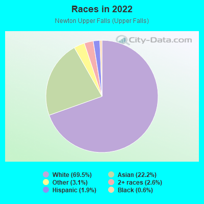
- 3,77369.5%White
- 1,20722.2%Asian
- 1673.1%Some other race
- 1402.6%Two or more races
- 1051.9%Hispanic or Latino
- 300.6%Black
- 40.07%Native Hawaiian and Other
Pacific Islander
Median household income in 2022:
| Newton Upper Falls (Upper Falls): | $189,616 |
| Massachusetts: | $94,488 |
Distribution of median household income
![Distribution of median household income]()
- 90Less than $10,000
- 80$10,000 to $19,999
- 104$20,000 to $29,999
- 77$30,000 to $39,999
- 123$40,000 to $49,999
- 74$50,000 to $59,999
- 193$60,000 to $74,999
- 234$75,000 to $99,999
- 110$100,000 to $124,999
- 162$125,000 to $149,999
- 208$150,000 to $199,999
- 822$200,000 or more

Distribution of owner-occupied house/condo value
![Distribution of owner-occupied house/condo value]()
- 109Less than $50,000
- 39$50,000 to $99,999
- 67$100,000 to $149,999
- 117$200,000 to $249,999
- 310$250,000 to $299,999
- 142$300,000 to $399,999
- 35$400,000 to $499,999
- 273$500,000 to $749,999
- 434$750,000 to $999,999
- 734$1,000,000 or more

Distribution of rent paid by renters
![Distribution of rent paid by renters]()
- 53Less than $100
- 44$100 to $199
- 37$200 to $299
- 34$300 to $399
- 31$500 to $599
- 27$600 to $699
- 57$700 to $799
- 10$800 to $899
- 168$900 to $999
- 26$1,000 to $1,249
- 15$1,250 to $1,499
- 206$1,500 to $1,999
- 1,513$2,000 or more

| Males: | 2,652 |
| Females: | 2,726 |
| Males: | 44.3 years |
| Females: | 46.3 years |
Average household size:
| Newton Upper Falls (Upper Falls): | 4.9 people |
| Massachusetts: | 2.4 people |
Percentage of family households:
| Newton Upper Falls (Upper Falls): | 53.7% |
| Massachusetts: | 43.1% |
| Here: | 57.1% |
| Massachusetts: | 45.2% |
Percentage of married-couple families with children (among all households):
| Newton Upper Falls (Upper Falls): | 29.9% |
| Massachusetts: | 56.2% |
Percentage of single-mother households (among all households):
| Newton Upper Falls (Upper Falls): | 8.0% |
| Massachusetts: | 8.7% |
Percentage of never married males 15 years old and over:
Percentage of never married females 15 years old and over:
| Newton Upper Falls (Upper Falls): | 15.1% |
| Massachusetts: | 19.4% |
Percentage of never married females 15 years old and over:
| Newton Upper Falls (Upper Falls): | 12.9% |
| Massachusetts: | 18.4% |
Percentage of people that speak English not well or not at all:
| Newton Upper Falls (Upper Falls): | 5.5% |
| Massachusetts: | 5.2% |
Percentage of people born in this state:
Percentage of people born in another U.S. state:
Percentage of native residents but born outside the U.S.:
Percentage of foreign born residents:
| Here: | 38.9% |
| Massachusetts: | 58.6% |
Percentage of people born in another U.S. state:
| Newton Upper Falls (Upper Falls): | 25.2% |
| Massachusetts: | 20.5% |
Percentage of native residents but born outside the U.S.:
| Here: | 1.6% |
| Massachusetts: | 2.8% |
Percentage of foreign born residents:
| Here: | 34.3% |
| Massachusetts: | 18.0% |
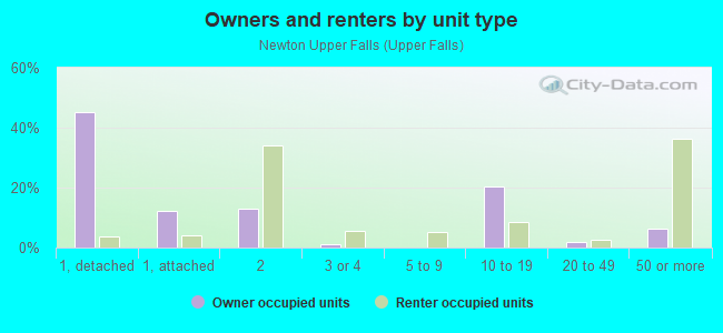
Owner-occupied
Renter-occupied

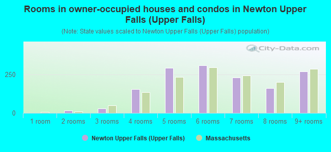
- Rooms in owner-occupied houses and condos in Newton Upper Falls <
> - 01 room
- 152 rooms
- 283 rooms
- 1544 rooms
- 2945 rooms
- 3096 rooms
- 2317 rooms
- 1608 rooms
- 2699+ rooms
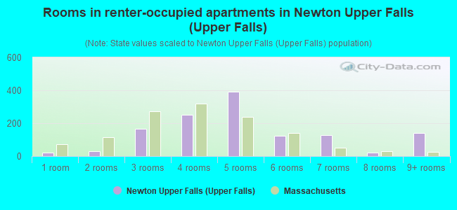
- Rooms in renter-occupied apartments in Newton Upper Falls <
> - 211 room
- 302 rooms
- 1643 rooms
- 2494 rooms
- 3915 rooms
- 1246 rooms
- 1267 rooms
- 218 rooms
- 1419+ rooms
Owner-occupied
Renter-occupied
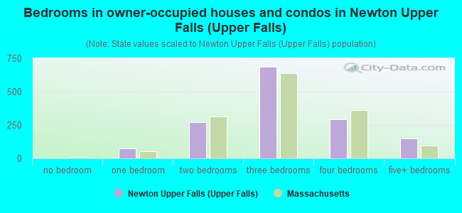
- Bedrooms in owner-occupied houses and condos in Newton Upper Falls <
> - 0no bedroom
- 771 bedroom
- 2712 bedrooms
- 6863 bedrooms
- 2924 bedrooms
- 1485+ bedrooms
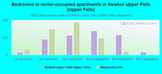
- Bedrooms in renter-occupied apartments in Newton Upper Falls <
> - 40no bedroom
- 2271 bedroom
- 2852 bedrooms
- 3473 bedrooms
- 2924 bedrooms
- 435+ bedrooms
Average number of cars or other vehicles available in houses/condos:
Average number of cars or other vehicles available in apartments:
| This neighborhood: | 1.9 |
| Massachusetts: | 2.0 |
Average number of cars or other vehicles available in apartments:
| Here: | |
| Massachusetts: |
Percentage of units with a mortgage:
| Newton Upper Falls (Upper Falls): | 62.6% |
| Massachusetts: | 65.5% |
Average estimated value of detached houses in 2022 (43.0% of all units):
| Newton Upper Falls (Upper Falls): | $1,465,334 |
| Massachusetts: | $651,570 |
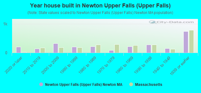
- Year house built in Newton Upper Falls <
> - 2092020 or later
- 1402010 to 2019
- 3252000 to 2009
- 2041990 to 1999
- 2181980 to 1989
- 831970 to 1979
- 2171960 to 1969
- 2821950 to 1959
- 1511940 to 1949
- 7471939 or earlier
Travel time to work (commute)
![Travel time to work (commute)]()
- 13Less than 5 minutes
- 1455 to 9 minutes
- 23210 to 14 minutes
- 33715 to 19 minutes
- 32720 to 24 minutes
- 10525 to 29 minutes
- 39930 to 34 minutes
- 6235 to 39 minutes
- 16140 to 44 minutes
- 40645 to 59 minutes
- 20860 to 89 minutes
- 6290 or more minutes

Means of transportation to work
![Means of transportation to work]()
- 56.0%1,537Drove a car alone
- 7.1%194Carpooled
- 2.2%59Bus
- 8.1%221Subway or elevated rail
- 1.6%43Long-distance train or commuter rail
- 2.0%54Light rail, streetcar or trolley
- 0.5%15Taxi
- 0.4%11Bicycle
- 2.9%80Walked
- 7.5%207Other means
- 23.8%652Worked at home

Time leaving home to go to work
![Time leaving home to go to work]()
- 2612:00 a.m. to 4:59 a.m.
- 285:00 a.m. to 5:29 a.m.
- 175:30 a.m. to 5:59 a.m.
- 1166:00 a.m. to 6:29 a.m.
- 1976:30 a.m. to 6:59 a.m.
- 3377:00 a.m. to 7:29 a.m.
- 3777:30 a.m. to 7:59 a.m.
- 3168:00 a.m. to 8:29 a.m.
- 2678:30 a.m. to 8:59 a.m.
- 3309:00 a.m. to 9:59 a.m.
- 11210:00 a.m. to 10:59 a.m.
- 1011:00 a.m. to 11:59 a.m.
- 21512:00 p.m. to 3:59 p.m.
- 1234:00 p.m. to 11:59 p.m.

Occupations of males:
- Percentage of males in management occupations (except farmers):
Here: 17.1% Massachusetts: 14.0%
- Percentage of males in business and financial operations occupations:
Here: 11.9% Massachusetts: 6.5%
- Percentage of males in computer and mathematical occupations:
Here: 7.7% Massachusetts: 6.9%
- Percentage of males in architecture and engineering occupations:
Here: 5.9% Massachusetts: 4.2%
- Percentage of males in life, physical, and social science occupations:
Here: 7.0% Massachusetts: 2.4%
- Percentage of males in legal occupations:
Here: 1.7% Massachusetts: 1.5%
- Percentage of males in education, training, and library occupations:
Here: 11.3% Massachusetts: 4.3%
- Percentage of males in arts, design, entertainment, sports, and media occupations:
Here: 2.9% Massachusetts: 2.2%
- Percentage of males in healthcare practitioners and technical occupations:
Here: 6.9% Massachusetts: 3.2%
- Percentage of males in service occupations:
Here: 4.1% Massachusetts: 13.5%
- Percentage of males in sales and office occupations:
Here: 10.2% Massachusetts: 14.0%
- Percentage of males in construction, extraction, and maintenance occupations:
Here: 1.7% Massachusetts: 8.2%
- Percentage of males in transportation occupations:
Here: 4.4% Massachusetts: 4.9%
Occupations of females:
- Percentage of females in management occupations (except farmers):
Here: 11.2% Massachusetts: 11.3%
- Percentage of females in business and financial operations occupations:
Here: 15.1% Massachusetts: 7.6%
- Percentage of females in computer and mathematical occupations:
Here: 4.3% Massachusetts: 2.6%
- Percentage of females in life, physical, and social science occupations:
Here: 12.7% Massachusetts: 2.4%
- Percentage of females in community and social services occupations:
Here: 2.0% Massachusetts: 3.1%
- Percentage of females in education, training, and library occupations:
Here: 14.2% Massachusetts: 10.9%
- Percentage of females in arts, design, entertainment, sports, and media occupations:
Here: 4.9% Massachusetts: 2.6%
- Percentage of females in healthcare practitioners and technical occupations:
Here: 12.1% Massachusetts: 10.8%
- Percentage of females in service occupations:
Here: 8.1% Massachusetts: 18.3%
- Percentage of females in sales and office occupations:
Here: 12.7% Massachusetts: 22.6%
- Percentage of females in production occupations:
Here: 1.7% Massachusetts: 2.5%
Education in this neighborhood (subdivision or community):
- Percentage of people 3 years and older in K-12 schools:
Newton Upper Falls (Upper Falls): 14.7% Massachusetts: 14.7%
- Percentage of people 3 years and older in undergraduate colleges:
Newton Upper Falls (Upper Falls): 6.9% Massachusetts: 5.9%
- Percentage of people 3 years and older in grad. or professional schools:
Newton Upper Falls (Upper Falls): 3.1% Massachusetts: 2.2%
- Percentage of students K-12 enrolled in private schools:
Newton Upper Falls (Upper Falls): 68.3% Massachusetts: 11.0%
Percentage of population below poverty level:
| Newton Upper Falls (Upper Falls): | 7.6% |
| Massachusetts: | 10.4% |
Median year owner moved in (as recorded in 2022):
| Newton Upper Falls (Upper Falls): | 2004 |
| Massachusetts: | 2009 |
Percentage of married-couple families with both working:
| Newton Upper Falls (Upper Falls): | 77.0% |
| Massachusetts: | 78.0% |
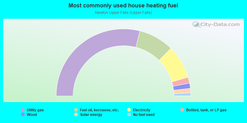
- 57.9%Utility gas
- 17.0%Fuel oil, kerosene, etc.
- 16.1%Electricity
- 2.9%Bottled, tank, or LP gas
- 2.5%Wood
- 2.1%Solar energy
- 1.5%No fuel used
Highways in this neighborhood:
State Hwy 9 (Boylston St)
Length: 2.44 miles
Direction: E-W
Address range: 822 to 1399
Direction: E-W
Address range: 822 to 1399
Roads and streets:
Winchester St
Length: 1.79 miles
Directions: N-S, SE-NW, SW-NE
Address range: 1 to 698
Directions: N-S, SE-NW, SW-NE
Address range: 1 to 698
Dedham St
Length: 1.58 miles
Directions: E-W, N-S, SE-NW, SW-NE
Address range: 1 to 670
Directions: E-W, N-S, SE-NW, SW-NE
Address range: 1 to 670
Elliot St
Length: 1.24 miles
Directions: E-W, N-S, SW-NE
Address range: 1 to 499
Directions: E-W, N-S, SW-NE
Address range: 1 to 499
Nahanton St
Length: 1.05 miles
Directions: E-W, SW-NE
Address range: 1 to 499
Directions: E-W, SW-NE
Address range: 1 to 499
Needham St
Length: 0.91 miles
Directions: N-S, SW-NE
Address range: 1 to 399
Directions: N-S, SW-NE
Address range: 1 to 399
Chestnut St
Length: 0.86 miles
Directions: E-W, N-S, SE-NW, SW-NE
Address range: 933 to 1299
Directions: E-W, N-S, SE-NW, SW-NE
Address range: 933 to 1299
Upland Ave
Length: 0.75 miles
Directions: E-W, N-S, SE-NW
Address range: 2 to 399
Directions: E-W, N-S, SE-NW
Address range: 2 to 399
Charlemont St
Length: 0.60 miles
Directions: E-W, N-S, SE-NW, SW-NE
Address range: 1 to 199
Directions: E-W, N-S, SE-NW, SW-NE
Address range: 1 to 199
Oak St
Length: 0.58 miles
Directions: E-W, N-S, SE-NW
Address range: 1 to 199
Directions: E-W, N-S, SE-NW
Address range: 1 to 199
High St
Length: 0.58 miles
Directions: E-W, N-S, SE-NW, SW-NE
Address range: 1 to 199
Directions: E-W, N-S, SE-NW, SW-NE
Address range: 1 to 199
Christina St
Length: 0.57 miles
Directions: E-W, SE-NW
Address range: 1 to 199
Directions: E-W, SE-NW
Address range: 1 to 199
Countryside Rd
Length: 0.56 miles
Directions: E-W, N-S, SE-NW, SW-NE
Address range: 1 to 211
Directions: E-W, N-S, SE-NW, SW-NE
Address range: 1 to 211
Thurston Rd
Length: 0.53 miles
Directions: E-W, N-S, SW-NE
Address range: 1 to 199
Directions: E-W, N-S, SW-NE
Address range: 1 to 199
Roundwood Rd
Length: 0.44 miles
Directions: E-W, N-S, SE-NW, SW-NE
Address range: 1 to 199
Directions: E-W, N-S, SE-NW, SW-NE
Address range: 1 to 199
Wallace St
Length: 0.40 miles
Directions: E-W, N-S, SE-NW, SW-NE
Address range: 1 to 199
Directions: E-W, N-S, SE-NW, SW-NE
Address range: 1 to 199
Walnut St
Length: 0.39 miles
Directions: N-S, SE-NW
Address range: 1259 to 1499
Directions: N-S, SE-NW
Address range: 1259 to 1499
Rachel Rd
Length: 0.39 miles
Directions: E-W, SW-NE
Address range: 1 to 136
Directions: E-W, SW-NE
Address range: 1 to 136
Andrew St
Length: 0.39 miles
Directions: E-W, N-S, SE-NW, SW-NE
Address range: 1 to 199
Directions: E-W, N-S, SE-NW, SW-NE
Address range: 1 to 199
Columbia Ave
Length: 0.38 miles
Directions: E-W, SE-NW, SW-NE
Address range: 1 to 199
Directions: E-W, SE-NW, SW-NE
Address range: 1 to 199
Bound Brook Rd
Length: 0.35 miles
Direction: E-W
Address range: 1 to 99
Direction: E-W
Address range: 1 to 99
Shady Hill Rd
Length: 0.31 miles
Directions: E-W, N-S, SE-NW
Address range: 1 to 199
Directions: E-W, N-S, SE-NW
Address range: 1 to 199
Rockland Pl
Length: 0.29 miles
Directions: E-W, N-S, SE-NW, SW-NE
Address range: 1 to 99
Directions: E-W, N-S, SE-NW, SW-NE
Address range: 1 to 99
Carl St
Length: 0.28 miles
Directions: E-W, N-S, SE-NW, SW-NE
Address range: 1 to 99
Directions: E-W, N-S, SE-NW, SW-NE
Address range: 1 to 99
Goddard St
Length: 0.28 miles
Direction: SW-NE
Address range: 1 to 99
Direction: SW-NE
Address range: 1 to 99
Pennsylvania Ave
Length: 0.28 miles
Direction: E-W
Address range: 1 to 99
Direction: E-W
Address range: 1 to 99
Circuit Ave
Length: 0.27 miles
Directions: N-S, SE-NW
Address range: 1 to 99
Directions: N-S, SE-NW
Address range: 1 to 99
Brush Hill Rd
Length: 0.27 miles
Directions: E-W, SE-NW, SW-NE
Address range: 1 to 99
Directions: E-W, SE-NW, SW-NE
Address range: 1 to 99
Heatherland Rd
Length: 0.27 miles
Direction: E-W
Address range: 1 to 99
Direction: E-W
Address range: 1 to 99
Ellis St
Length: 0.23 miles
Directions: N-S, SE-NW
Address range: 1 to 99
Directions: N-S, SE-NW
Address range: 1 to 99
Bernard St
Length: 0.22 miles
Direction: SE-NW
Address range: 1 to 99
Direction: SE-NW
Address range: 1 to 99
Margaret Rd
Length: 0.22 miles
Direction: SE-NW
Address range: 1 to 99
Direction: SE-NW
Address range: 1 to 99
Indiana Ter
Length: 0.22 miles
Directions: E-W, N-S, SE-NW, SW-NE
Address range: 1 to 99
Directions: E-W, N-S, SE-NW, SW-NE
Address range: 1 to 99
Stoney Brae Rd
Length: 0.22 miles
Directions: E-W, SW-NE
Address range: 1 to 99
Directions: E-W, SW-NE
Address range: 1 to 99
Jaconnet St
Length: 0.21 miles
Directions: E-W, SE-NW
Address range: 1 to 99
Directions: E-W, SE-NW
Address range: 1 to 99
Rockland St
Length: 0.21 miles
Directions: E-W, SE-NW, SW-NE
Address range: 1 to 28
Directions: E-W, SE-NW, SW-NE
Address range: 1 to 28
Wade St
Length: 0.21 miles
Directions: E-W, SE-NW
Address range: 1 to 99
Directions: E-W, SE-NW
Address range: 1 to 99
Cottage St
Length: 0.21 miles
Directions: N-S, SE-NW
Address range: 1 to 84
Directions: N-S, SE-NW
Address range: 1 to 84
Linden St
Length: 0.20 miles
Directions: N-S, SW-NE
Address range: 1 to 99
Directions: N-S, SW-NE
Address range: 1 to 99
Ossipee Rd
Length: 0.20 miles
Directions: E-W, SW-NE
Address range: 1 to 198
Directions: E-W, SW-NE
Address range: 1 to 198
Druid Hill Rd
Length: 0.18 miles
Directions: N-S, SE-NW, SW-NE
Address range: 1 to 99
Directions: N-S, SE-NW, SW-NE
Address range: 1 to 99
Wetherell St
Length: 0.18 miles
Directions: E-W, N-S, SE-NW, SW-NE
Address range: 1 to 99
Directions: E-W, N-S, SE-NW, SW-NE
Address range: 1 to 99
Kenneth St
Length: 0.18 miles
Direction: SW-NE
Address range: 1 to 99
Direction: SW-NE
Address range: 1 to 99
Tower Rd
Length: 0.17 miles
Direction: E-W
Address range: 1 to 99
Direction: E-W
Address range: 1 to 99
Verndale Rd
Length: 0.17 miles
Direction: N-S
Address range: 1 to 99
Direction: N-S
Address range: 1 to 99
Murley Ln
Length: 0.17 miles
Directions: N-S, SW-NE
Address range: 1 to 99
Directions: N-S, SW-NE
Address range: 1 to 99
Dane Hill Rd
Length: 0.16 miles
Directions: N-S, SE-NW
Address range: 1 to 199
Directions: N-S, SE-NW
Address range: 1 to 199
Industrial Pl
Length: 0.16 miles
Direction: E-W
Address range: 1 to 99
Direction: E-W
Address range: 1 to 99
Champa St
Length: 0.16 miles
Directions: E-W, SE-NW, SW-NE
Address range: 1 to 99
Directions: E-W, SE-NW, SW-NE
Address range: 1 to 99
White Pine Rd
Length: 0.16 miles
Directions: E-W, N-S, SE-NW, SW-NE
Address range: 1 to 99
Directions: E-W, N-S, SE-NW, SW-NE
Address range: 1 to 99
Roland St
Length: 0.16 miles
Directions: E-W, SW-NE
Address range: 1 to 99
Directions: E-W, SW-NE
Address range: 1 to 99
Mechanic St
Length: 0.15 miles
Directions: N-S, SE-NW, SW-NE
Address range: 1 to 99
Directions: N-S, SE-NW, SW-NE
Address range: 1 to 99
Sullivan Ave
Length: 0.15 miles
Directions: E-W, N-S, SE-NW
Address range: 1 to 99
Directions: E-W, N-S, SE-NW
Address range: 1 to 99
Hale St
Length: 0.15 miles
Direction: N-S
Address range: 1 to 99
Direction: N-S
Address range: 1 to 99
Hickory Cliff Rd
Length: 0.14 miles
Direction: N-S
Address range: 1 to 99
Direction: N-S
Address range: 1 to 99
Briarfield Rd
Length: 0.14 miles
Direction: N-S
Address range: 1 to 99
Direction: N-S
Address range: 1 to 99
River Ave
Length: 0.13 miles
Directions: E-W, N-S, SW-NE
Address range: 1 to 99
Directions: E-W, N-S, SW-NE
Address range: 1 to 99
Nod Hill Rd
Length: 0.13 miles
Direction: E-W
Address range: 1 to 99
Direction: E-W
Address range: 1 to 99
Frances St
Length: 0.12 miles
Direction: E-W
Address range: 1 to 99
Direction: E-W
Address range: 1 to 99
Winchester Plz
Length: 0.12 miles
Directions: E-W, SE-NW, SW-NE
Address range: 1 to 99
Directions: E-W, SE-NW, SW-NE
Address range: 1 to 99
Summer St
Length: 0.12 miles
Direction: E-W
Address range: 1 to 99
Direction: E-W
Address range: 1 to 99
Stephens Pl
Length: 0.12 miles
Directions: E-W, SE-NW
Address range: 1 to 99
Directions: E-W, SE-NW
Address range: 1 to 99
Ramsdell St
Length: 0.12 miles
Directions: E-W, SE-NW
Address range: 1 to 99
Directions: E-W, SE-NW
Address range: 1 to 99
Willard St
Length: 0.12 miles
Direction: SW-NE
Address range: 1 to 125
Direction: SW-NE
Address range: 1 to 125
Chandler Pl
Length: 0.12 miles
Direction: SW-NE
Address range: 1 to 99
Direction: SW-NE
Address range: 1 to 99
Williams St
Length: 0.11 miles
Directions: N-S, SW-NE
Address range: 1 to 99
Directions: N-S, SW-NE
Address range: 1 to 99
Butts St
Length: 0.10 miles
Directions: E-W, SE-NW
Address range: 1 to 99
Directions: E-W, SE-NW
Address range: 1 to 99
Mosley Rd
Length: 0.10 miles
Directions: E-W, SE-NW
Address range: 1 to 99
Directions: E-W, SE-NW
Address range: 1 to 99
Cliff Rd
Length: 0.10 miles
Direction: E-W
Address range: 1 to 99
Direction: E-W
Address range: 1 to 99
Keefe Ave
Length: 0.10 miles
Directions: E-W, N-S, SE-NW
Address range: 1 to 99
Directions: E-W, N-S, SE-NW
Address range: 1 to 99
Winter St
Length: 0.10 miles
Direction: E-W
Address range: 1 to 99
Direction: E-W
Address range: 1 to 99
Leewood Rd
Length: 0.10 miles
Directions: N-S, SW-NE
Address range: 1 to 99
Directions: N-S, SW-NE
Address range: 1 to 99
Lucille Pl
Length: 0.10 miles
Directions: N-S, SE-NW
Address range: 1 to 99
Directions: N-S, SE-NW
Address range: 1 to 99
Cheney St
Length: 0.09 miles
Direction: E-W
Address range: 1 to 99
Direction: E-W
Address range: 1 to 99
Walnut Pl
Length: 0.09 miles
Directions: E-W, SE-NW
Address range: 32 to 66
Directions: E-W, SE-NW
Address range: 32 to 66
Old Winchester St
Length: 0.09 miles
Directions: N-S, SE-NW
Address range: 1 to 298
Directions: N-S, SE-NW
Address range: 1 to 298
Josselyn Pl
Length: 0.08 miles
Direction: E-W
Address range: 1 to 99
Direction: E-W
Address range: 1 to 99
Charles St
Length: 0.08 miles
Direction: E-W
Address range: 1 to 99
Direction: E-W
Address range: 1 to 99
Elliot Ter
Length: 0.08 miles
Direction: SE-NW
Address range: 1 to 99
Direction: SE-NW
Address range: 1 to 99
Malubar Ln
Length: 0.08 miles
Directions: E-W, SE-NW
Address range: 1 to 99
Directions: E-W, SE-NW
Address range: 1 to 99
Abbott St
Length: 0.07 miles
Directions: N-S, SW-NE
Address range: 1 to 99
Directions: N-S, SW-NE
Address range: 1 to 99
Hemlock Rd
Length: 0.07 miles
Direction: N-S
Address range: 1 to 99
Direction: N-S
Address range: 1 to 99
Tamarac Rd
Length: 0.07 miles
Directions: E-W, SW-NE
Address range: 1 to 99
Directions: E-W, SW-NE
Address range: 1 to 99
Charles River Ter
Length: 0.07 miles
Direction: SW-NE
Address range: 1 to 99
Direction: SW-NE
Address range: 1 to 99
Sutcliffe Park
Length: 0.07 miles
Directions: E-W, SW-NE
Address range: 1 to 99
Directions: E-W, SW-NE
Address range: 1 to 99
Pettee St
Length: 0.06 miles
Directions: E-W, N-S, SW-NE
Address range: 1 to 99
Directions: E-W, N-S, SW-NE
Address range: 1 to 99
Patten Cir
Length: 0.06 miles
Direction: SE-NW
Address range: 1 to 99
Direction: SE-NW
Address range: 1 to 99
Elliot Pl
Length: 0.06 miles
Direction: N-S
Address range: 1 to 99
Direction: N-S
Address range: 1 to 99
Suban Pl
Length: 0.06 miles
Direction: E-W
Address range: 1 to 99
Direction: E-W
Address range: 1 to 99
Saco St
Length: 0.06 miles
Directions: E-W, N-S, SW-NE
Address range: 1 to 105
Directions: E-W, N-S, SW-NE
Address range: 1 to 105
Buff Cir
Length: 0.06 miles
Directions: E-W, SE-NW
Address range: 1 to 99
Directions: E-W, SE-NW
Address range: 1 to 99
Ledgewood Rd
Length: 0.05 miles
Directions: E-W, N-S, SW-NE
Address range: 1 to 99
Directions: E-W, N-S, SW-NE
Address range: 1 to 99
Spring St
Length: 0.05 miles
Direction: N-S
Address range: 1 to 99
Direction: N-S
Address range: 1 to 99
Sweet St
Length: 0.05 miles
Direction: SW-NE
Address range: 1 to 99
Direction: SW-NE
Address range: 1 to 99
Easy St
Length: 0.05 miles
Direction: SE-NW
Address range: 1 to 99
Direction: SE-NW
Address range: 1 to 99
Shawmut Park
Length: 0.05 miles
Direction: N-S
Address range: 1 to 99
Direction: N-S
Address range: 1 to 99
Hersey St
Length: 0.05 miles
Direction: SW-NE
Address range: 1 to 99
Direction: SW-NE
Address range: 1 to 99
Bank St
Length: 0.04 miles
Direction: SW-NE
Address range: 1 to 99
Direction: SW-NE
Address range: 1 to 99
Chilton Pl
Length: 0.04 miles
Directions: E-W, N-S, SW-NE
Address range: 1 to 21
Directions: E-W, N-S, SW-NE
Address range: 1 to 21
Ohio Ave
Length: 0.04 miles
Directions: N-S, SE-NW
Address range: 1 to 99
Directions: N-S, SE-NW
Address range: 1 to 99
Curtis St
Length: 0.04 miles
Direction: E-W
Address range: 1 to 99
Direction: E-W
Address range: 1 to 99
Ashcroft Rd
Length: 0.04 miles
Direction: SW-NE
Address range: 1 to 99
Direction: SW-NE
Address range: 1 to 99
Cheney Ct
Length: 0.04 miles
Direction: N-S
Address range: 1 to 99
Direction: N-S
Address range: 1 to 99
Indiana Ct
Length: 0.03 miles
Direction: N-S
Address range: 1 to 99
Direction: N-S
Address range: 1 to 99
Hillside Ln
Length: 0.03 miles
Direction: N-S
Direction: N-S
Railroad features:
Penn Central RR
Length: 2.03 miles
Directions: E-W, N-S, SE-NW, SW-NE
Directions: E-W, N-S, SE-NW, SW-NE
Mass transit rail lines:
Mbta Green Line Trolley
Length: 0.53 miles
Directions: E-W, SE-NW, SW-NE
Directions: E-W, SE-NW, SW-NE
Other features:
Charles Riv
Length: 2.11 miles
Directions: E-W, N-S, SE-NW, SW-NE
Directions: E-W, N-S, SE-NW, SW-NE
Meadow Brk
Length: 1.03 miles
Directions: E-W, N-S, SW-NE
Directions: E-W, N-S, SW-NE
Other features:
Cochituate Aqueduct (Historical)
Length: 0.26 miles
Direction: SW-NE
Direction: SW-NE
Other features:
South Meadow Brk
Length: 0.04 miles
Direction: SW-NE
Direction: SW-NE
Roads and streets:
Railroad features:
Penn Central RR
Length: 0.03 miles
Direction: SW-NE
Direction: SW-NE
Other features:
Charles Riv
Length: 2.11 miles
Directions: E-W, N-S, SE-NW, SW-NE
Directions: E-W, N-S, SE-NW, SW-NE