North Commons (North Common) neighborhood in Quincy, Massachusetts (MA), 02169 detailed profile
Settings
X


Business Search - 14 Million verified businesses
Area: 0.730 square miles
Population: 3,932
Population density:
| North Commons (North Common): | 5,386 people per square mile |
| Quincy: | 6,060 people per square mile |

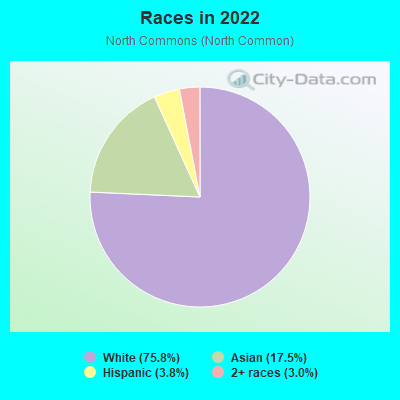
- 2,97975.8%White
- 68617.5%Asian
- 1493.8%Hispanic or Latino
- 1163.0%Two or more races

Median household income in 2022:
| North Commons (North Common): | $146,949 |
| Quincy: | $90,205 |
Distribution of median household income
![Distribution of median household income]()
- 20$10,000 to $19,999
- 127$20,000 to $29,999
- 30$30,000 to $39,999
- 177$50,000 to $59,999
- 67$75,000 to $99,999
- 144$100,000 to $124,999
- 254$125,000 to $149,999
- 137$150,000 to $199,999
- 507$200,000 or more

Distribution of owner-occupied house/condo value
![Distribution of owner-occupied house/condo value]()
- 34$100,000 to $149,999
- 84$400,000 to $499,999
- 304$500,000 to $749,999
- 357$750,000 to $999,999
- 227$1,000,000 or more

Distribution of rent paid by renters
![Distribution of rent paid by renters]()
- 187$1,500 to $1,999
- 270$2,000 or more

Median rent in 2022:
| North Commons (North Common): | $2,123 |
| Quincy: | $1,759 |
| Males: | 1,786 |
| Females: | 2,145 |
Males:
| This neighborhood: | 41.4 years |
| Whole city: | 37.6 years |
| This neighborhood: | 33.3 years |
| Whole city: | 43.7 years |
Average household size:
| North Commons (North Common): | 2.7 people |
| Quincy: | 2.1 people |
Percentage of family households:
| North Commons (North Common): | 50.9% |
| Quincy: | 36.2% |
| Here: | 62.6% |
| Quincy: | 39.5% |
Percentage of married-couple families with children (among all households):
| North Commons (North Common): | 37.1% |
| Quincy: | 35.4% |
Percentage of single-mother households (among all households):
| North Commons (North Common): | 0.0% |
| Quincy: | 7.9% |
Percentage of never married males 15 years old and over:
Percentage of never married females 15 years old and over:
| North Commons (North Common): | 13.7% |
| Quincy: | 20.7% |
Percentage of never married females 15 years old and over:
| North Commons (North Common): | 18.2% |
| city: | 17.4% |
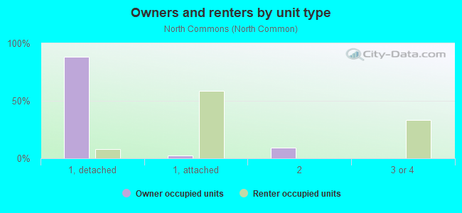
Owner-occupied
Renter-occupied

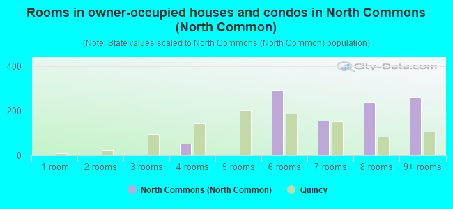
- Rooms in owner-occupied houses and condos in North Commons <
> - 01 room
- 02 rooms
- 03 rooms
- 534 rooms
- 05 rooms
- 2936 rooms
- 1567 rooms
- 2368 rooms
- 2639+ rooms

- Rooms in renter-occupied apartments in North Commons <
> - 01 room
- 02 rooms
- 333 rooms
- 3864 rooms
- 05 rooms
- 06 rooms
- 07 rooms
- 368 rooms
- 09+ rooms
Owner-occupied
Renter-occupied
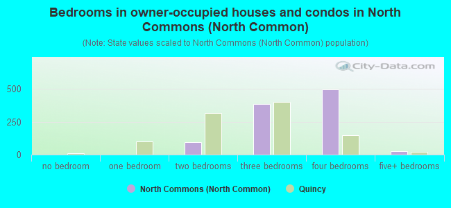
- Bedrooms in owner-occupied houses and condos in North Commons <
> - 0no bedroom
- 01 bedroom
- 932 bedrooms
- 3833 bedrooms
- 4964 bedrooms
- 295+ bedrooms
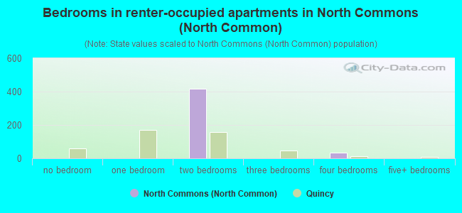
- Bedrooms in renter-occupied apartments in North Commons <
> - 0no bedroom
- 01 bedroom
- 4192 bedrooms
- 03 bedrooms
- 364 bedrooms
- 05+ bedrooms
Average number of cars or other vehicles available in houses/condos:
Average number of cars or other vehicles available in apartments:
| This neighborhood: | 2.1 |
| Quincy: | 1.6 |
Average number of cars or other vehicles available in apartments:
| Here: | 2.1 |
| city: | 1.0 |
Percentage of units with a mortgage:
| North Commons (North Common): | 82.1% |
| Quincy: | 62.1% |
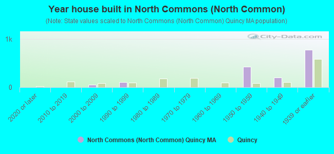
- Year house built in North Commons <
> - 02020 or later
- 02010 to 2019
- 562000 to 2009
- 1031990 to 1999
- 01980 to 1989
- 01970 to 1979
- 01960 to 1969
- 4191950 to 1959
- 1991940 to 1949
- 7691939 or earlier
City-data.com crime index for city in 2020 (higher means more crime):
| City: | 146.2 |
| U.S. average: | 219.5 |
Means of transportation to work
![Means of transportation to work]()
- 65.7%1,489Drove a car alone
- 9.2%209Carpooled
- 2.2%49Subway or elevated rail
- 2.3%53Walked
- 20.4%463Worked at home

Occupations of males:
- Percentage of males in management occupations (except farmers):
Here: 10.2% city: 12.6%
- Percentage of males in business and financial operations occupations:
Here: 28.9% city: 8.0%
- Percentage of males in computer and mathematical occupations:
Here: 14.6% city: 10.4%
- Percentage of males in architecture and engineering occupations:
Here: 3.2% city: 3.0%
- Percentage of males in legal occupations:
Here: 2.3% city: 2.2%
- Percentage of males in healthcare practitioners and technical occupations:
Here: 2.9% city: 3.3%
- Percentage of males in service occupations:
Here: 9.1% city: 15.2%
- Percentage of males in sales and office occupations:
Here: 2.3% city: 16.0%
- Percentage of males in construction, extraction, and maintenance occupations:
Here: 10.5% city: 5.1%
- Percentage of males in production occupations:
Here: 5.8% city: 3.5%
- Percentage of males in transportation occupations:
Here: 9.9% city: 4.9%
Occupations of females:
- Percentage of females in management occupations (except farmers):
Here: 12.4% city: 11.4%
- Percentage of females in business and financial operations occupations:
Here: 19.3% city: 11.1%
- Percentage of females in computer and mathematical occupations:
Here: 2.0% city: 4.1%
- Percentage of females in education, training, and library occupations:
Here: 8.1% city: 9.1%
- Percentage of females in healthcare practitioners and technical occupations:
Here: 23.3% city: 9.7%
- Percentage of females in service occupations:
Here: 16.4% city: 19.9%
- Percentage of females in sales and office occupations:
Here: 14.1% city: 22.1%
- Percentage of females in material moving occupations:
Here: 4.3% city: 0.8%
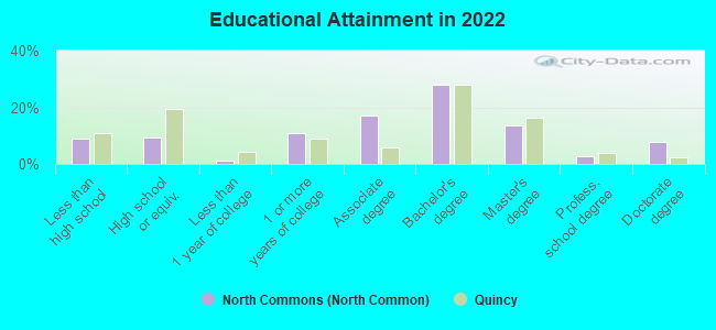
Education in this neighborhood (subdivision or community):
- Percentage of people 3 years and older in K-12 schools:
North Commons (North Common): 5.8% Quincy: 11.7%
- Percentage of people 3 years and older in undergraduate colleges:
North Commons (North Common): 2.5% Quincy: 6.1%
- Percentage of people 3 years and older in grad. or professional schools:
North Commons (North Common): 3.6% Quincy: 3.6%
- Percentage of students K-12 enrolled in private schools:
North Commons (North Common): 57.8% Quincy: 10.2%
Median year owner moved in (as recorded in 2022):
Median year renter moved in (as recorded in 2022):
| North Commons (North Common): | 2006 |
| Quincy: | 2009 |
Median year renter moved in (as recorded in 2022):
| North Commons (North Common): | 2019 |
| Quincy: | 2019 |
Percentage of married-couple families with both working:
| North Commons (North Common): | 84.8% |
| Quincy: | 63.7% |
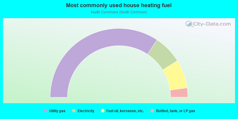
- 68.7%Utility gas
- 13.6%Electricity
- 13.4%Fuel oil, kerosene, etc.
- 4.4%Bottled, tank, or LP gas
Roads and streets:
Quarry St
Length: 1.38 miles
Directions: E-W, SE-NW
Address range: 1 to 465
Directions: E-W, SE-NW
Address range: 1 to 465
Granite St
Length: 1.02 miles
Directions: E-W, N-S, SW-NE
Address range: 67 to 375
Directions: E-W, N-S, SW-NE
Address range: 67 to 375
Common St
Length: 0.80 miles
Directions: N-S, SE-NW
Address range: 1 to 316
Directions: N-S, SE-NW
Address range: 1 to 316
Water St
Length: 0.72 miles
Directions: E-W, SW-NE
Address range: 181 to 405
Directions: E-W, SW-NE
Address range: 181 to 405
Burgin Pkwy (Thomas E Burgin Pkwy)
Length: 0.53 miles
Direction: N-S
Address range: 40 to 118
Direction: N-S
Address range: 40 to 118
Copeland St
Length: 0.52 miles
Direction: E-W
Address range: 1 to 165
Direction: E-W
Address range: 1 to 165
Suomi Rd
Length: 0.51 miles
Directions: E-W, N-S, SE-NW, SW-NE
Address range: 1 to 199
Directions: E-W, N-S, SE-NW, SW-NE
Address range: 1 to 199
Garfield St
Length: 0.40 miles
Directions: E-W, N-S, SE-NW, SW-NE
Address range: 1 to 199
Directions: E-W, N-S, SE-NW, SW-NE
Address range: 1 to 199
Cranch St
Length: 0.34 miles
Direction: E-W
Address range: 25 to 199
Direction: E-W
Address range: 25 to 199
School St
Length: 0.33 miles
Directions: E-W, SE-NW
Address range: 111 to 299
Directions: E-W, SE-NW
Address range: 111 to 299
Whitwell St
Length: 0.30 miles
Direction: E-W
Address range: 232 to 399
Direction: E-W
Address range: 232 to 399
Quincy St
Length: 0.30 miles
Directions: E-W, N-S, SW-NE
Address range: 1 to 124
Directions: E-W, N-S, SW-NE
Address range: 1 to 124
Brook Rd
Length: 0.28 miles
Directions: E-W, N-S, SW-NE
Address range: 1 to 101
Directions: E-W, N-S, SW-NE
Address range: 1 to 101
Arthur St
Length: 0.28 miles
Direction: E-W
Address range: 1 to 99
Direction: E-W
Address range: 1 to 99
Cityview Ln
Length: 0.28 miles
Directions: E-W, N-S, SE-NW, SW-NE
Directions: E-W, N-S, SE-NW, SW-NE
Packards Ln
Length: 0.27 miles
Directions: E-W, N-S, SE-NW
Address range: 1 to 64
Directions: E-W, N-S, SE-NW
Address range: 1 to 64
Dayton St
Length: 0.26 miles
Direction: N-S
Address range: 1 to 199
Direction: N-S
Address range: 1 to 199
Pleasant St
Length: 0.26 miles
Directions: E-W, N-S, SE-NW
Address range: 1 to 199
Directions: E-W, N-S, SE-NW
Address range: 1 to 199
Scotch Pond Pl
Length: 0.26 miles
Direction: E-W
Address range: 54 to 99
Direction: E-W
Address range: 54 to 99
Churchill Rd
Length: 0.25 miles
Direction: E-W
Address range: 1 to 99
Direction: E-W
Address range: 1 to 99
Tinson Rd
Length: 0.24 miles
Direction: E-W
Address range: 1 to 99
Direction: E-W
Address range: 1 to 99
Parker St
Length: 0.23 miles
Directions: E-W, SE-NW
Address range: 1 to 99
Directions: E-W, SE-NW
Address range: 1 to 99
Furnace Brook Pkwy
Length: 0.23 miles
Direction: SE-NW
Address range: 1009 to 1230
Direction: SE-NW
Address range: 1009 to 1230
Jackson St
Length: 0.23 miles
Directions: E-W, N-S, SW-NE
Address range: 1 to 99
Directions: E-W, N-S, SW-NE
Address range: 1 to 99
Smith St
Length: 0.22 miles
Directions: N-S, SE-NW
Address range: 1 to 99
Directions: N-S, SE-NW
Address range: 1 to 99
Jenness St
Length: 0.21 miles
Direction: E-W
Address range: 13 to 99
Direction: E-W
Address range: 13 to 99
Grogan Ave
Length: 0.21 miles
Directions: N-S, SW-NE
Address range: 1 to 99
Directions: N-S, SW-NE
Address range: 1 to 99
Mount Ararat Rd
Length: 0.19 miles
Directions: E-W, N-S, SE-NW, SW-NE
Address range: 1 to 99
Directions: E-W, N-S, SE-NW, SW-NE
Address range: 1 to 99
Buckley St
Length: 0.19 miles
Directions: N-S, SW-NE
Address range: 1 to 99
Directions: N-S, SW-NE
Address range: 1 to 99
Harris St
Length: 0.19 miles
Directions: E-W, N-S
Address range: 1 to 99
Directions: E-W, N-S
Address range: 1 to 99
Curtis St
Length: 0.18 miles
Direction: E-W
Address range: 1 to 199
Direction: E-W
Address range: 1 to 199
Dunns Hill Rd
Length: 0.17 miles
Directions: E-W, N-S, SW-NE
Address range: 1 to 99
Directions: E-W, N-S, SW-NE
Address range: 1 to 99
Prout St
Length: 0.17 miles
Directions: E-W, N-S
Address range: 1 to 199
Directions: E-W, N-S
Address range: 1 to 199
Morton St
Length: 0.17 miles
Direction: E-W
Address range: 1 to 99
Direction: E-W
Address range: 1 to 99
Reardon St
Length: 0.17 miles
Direction: E-W
Address range: 1 to 45
Direction: E-W
Address range: 1 to 45
Filbert St
Length: 0.16 miles
Direction: N-S
Address range: 1 to 99
Direction: N-S
Address range: 1 to 99
Kidder St
Length: 0.15 miles
Directions: N-S, SE-NW
Address range: 1 to 99
Directions: N-S, SE-NW
Address range: 1 to 99
Nelson St
Length: 0.15 miles
Direction: N-S
Address range: 1 to 99
Direction: N-S
Address range: 1 to 99
Barry St
Length: 0.15 miles
Directions: E-W, N-S
Address range: 1 to 99
Directions: E-W, N-S
Address range: 1 to 99
Roosevelt Rd
Length: 0.14 miles
Direction: E-W
Address range: 1 to 99
Direction: E-W
Address range: 1 to 99
Deldorf St
Length: 0.13 miles
Directions: N-S, SW-NE
Address range: 1 to 99
Directions: N-S, SW-NE
Address range: 1 to 99
Carlson St
Length: 0.12 miles
Directions: E-W, N-S, SE-NW
Address range: 1 to 99
Directions: E-W, N-S, SE-NW
Address range: 1 to 99
Adams St
Length: 0.12 miles
Direction: E-W
Address range: 436 to 543
Direction: E-W
Address range: 436 to 543
Gordon Ter
Length: 0.11 miles
Directions: E-W, N-S, SE-NW, SW-NE
Address range: 1 to 99
Directions: E-W, N-S, SE-NW, SW-NE
Address range: 1 to 99
Fairview Rd
Length: 0.11 miles
Direction: E-W
Address range: 1 to 99
Direction: E-W
Address range: 1 to 99
Mount Vernon St
Length: 0.11 miles
Direction: N-S
Address range: 1 to 99
Direction: N-S
Address range: 1 to 99
Gothland St
Length: 0.10 miles
Direction: E-W
Address range: 1 to 99
Direction: E-W
Address range: 1 to 99
Carrolls Ln
Length: 0.10 miles
Directions: N-S, SW-NE
Address range: 2 to 99
Directions: N-S, SW-NE
Address range: 2 to 99
Fort St
Length: 0.09 miles
Direction: N-S
Address range: 1 to 99
Direction: N-S
Address range: 1 to 99
Marsh St
Length: 0.09 miles
Directions: E-W, N-S, SW-NE
Address range: 1 to 99
Directions: E-W, N-S, SW-NE
Address range: 1 to 99
Prospect Hill St
Length: 0.09 miles
Direction: E-W
Address range: 1 to 99
Direction: E-W
Address range: 1 to 99
Granite Ledge St
Length: 0.08 miles
Directions: E-W, SW-NE
Address range: 29 to 37
Directions: E-W, SW-NE
Address range: 29 to 37
Madden St
Length: 0.08 miles
Directions: N-S, SE-NW
Address range: 1 to 99
Directions: N-S, SE-NW
Address range: 1 to 99
Rowley St
Length: 0.08 miles
Direction: E-W
Address range: 1 to 99
Direction: E-W
Address range: 1 to 99
Booth St
Length: 0.08 miles
Direction: SW-NE
Address range: 1 to 99
Direction: SW-NE
Address range: 1 to 99
Rockview Rd
Length: 0.07 miles
Directions: N-S, SW-NE
Address range: 1 to 99
Directions: N-S, SW-NE
Address range: 1 to 99
Carlmark St
Length: 0.06 miles
Directions: E-W, N-S
Address range: 1 to 99
Directions: E-W, N-S
Address range: 1 to 99
Stevens St
Length: 0.06 miles
Direction: N-S
Address range: 1 to 99
Direction: N-S
Address range: 1 to 99
Garrett Dr
Length: 0.06 miles
Direction: E-W
Direction: E-W
Highpoint Cir
Length: 0.06 miles
Direction: SW-NE
Direction: SW-NE
Payson St
Length: 0.06 miles
Direction: SE-NW
Address range: 1 to 99
Direction: SE-NW
Address range: 1 to 99
Old Coach Rd
Length: 0.06 miles
Direction: N-S
Address range: 1 to 99
Direction: N-S
Address range: 1 to 99
Dunmore St
Length: 0.06 miles
Direction: N-S
Address range: 1 to 99
Direction: N-S
Address range: 1 to 99
Fallon Ct
Length: 0.05 miles
Direction: N-S
Address range: 1 to 50
Direction: N-S
Address range: 1 to 50
Mattson St
Length: 0.05 miles
Direction: SW-NE
Address range: 1 to 99
Direction: SW-NE
Address range: 1 to 99
Arthur Ave
Length: 0.05 miles
Directions: N-S, SE-NW
Address range: 1 to 99
Directions: N-S, SE-NW
Address range: 1 to 99
Rustic Pl
Length: 0.04 miles
Direction: E-W
Address range: 1 to 99
Direction: E-W
Address range: 1 to 99
Terrace St
Length: 0.04 miles
Direction: E-W
Address range: 1 to 99
Direction: E-W
Address range: 1 to 99
Ernest Ave
Length: 0.04 miles
Direction: SW-NE
Address range: 1 to 99
Direction: SW-NE
Address range: 1 to 99
Dunns Ct
Length: 0.04 miles
Directions: N-S, SW-NE
Address range: 1 to 99
Directions: N-S, SW-NE
Address range: 1 to 99
Prospect Hill
Length: 0.03 miles
Direction: N-S
Address range: 186 to 199
Direction: N-S
Address range: 186 to 199
Nilsen Ave
Length: 0.02 miles
Direction: N-S
Address range: 1 to 14
Direction: N-S
Address range: 1 to 14