Northside neighborhood in Haledon, New Jersey (NJ), 07522, 07506, 07508 detailed profile
Settings
X


Business Search - 14 Million verified businesses
Area: 1.242 square miles
Population: 26,954
Population density:
| Northside: | 21,695 people per square mile |
| Haledon: | 7,709 people per square mile |

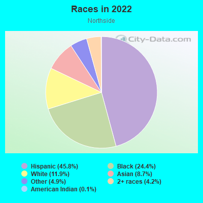
- 14,65945.8%Hispanic or Latino
- 7,80224.4%Black
- 3,80111.9%White
- 2,7788.7%Asian
- 1,5654.9%Some other race
- 1,3454.2%Two or more races
- 450.1%American Indian
Distribution of median household income
![Distribution of median household income]()
- 737Less than $10,000
- 911$10,000 to $19,999
- 1,664$20,000 to $29,999
- 1,244$30,000 to $39,999
- 1,176$40,000 to $49,999
- 716$50,000 to $59,999
- 758$60,000 to $74,999
- 871$75,000 to $99,999
- 724$100,000 to $124,999
- 531$125,000 to $149,999
- 651$150,000 to $199,999
- 645$200,000 or more

Distribution of owner-occupied house/condo value
![Distribution of owner-occupied house/condo value]()
- 641Less than $50,000
- 657$50,000 to $99,999
- 2,199$100,000 to $149,999
- 494$150,000 to $199,999
- 977$200,000 to $249,999
- 627$250,000 to $299,999
- 747$300,000 to $399,999
- 638$400,000 to $499,999
- 531$500,000 to $749,999
- 322$750,000 to $999,999
- 1,003$1,000,000 or more

Distribution of rent paid by renters
![Distribution of rent paid by renters]()
- 194Less than $100
- 637$100 to $199
- 749$200 to $299
- 774$300 to $399
- 490$400 to $499
- 287$500 to $599
- 664$600 to $699
- 614$700 to $799
- 620$800 to $899
- 255$900 to $999
- 1,223$1,000 to $1,249
- 1,796$1,250 to $1,499
- 1,942$1,500 to $1,999
- 343$2,000 or more

Median rent in 2022:
| Northside: | $1,358 |
| Haledon: | $1,355 |
| Males: | 13,472 |
| Females: | 13,482 |
Males:
| This neighborhood: | 28.7 years |
| Whole city: | 37.7 years |
| This neighborhood: | 33.9 years |
| Whole city: | 41.2 years |
Average household size:
| Northside: | 7.7 people |
| Haledon: | 2.8 people |
Percentage of family households:
| Northside: | 64.9% |
| Haledon: | 51.7% |
| Here: | 30.2% |
| Haledon: | 43.9% |
Percentage of married-couple families with children (among all households):
| Northside: | 11.2% |
| Haledon: | 21.4% |
Percentage of single-mother households (among all households):
| Northside: | 16.6% |
| Haledon: | 11.0% |
Percentage of never married males 15 years old and over:
Percentage of never married females 15 years old and over:
| Northside: | 28.0% |
| Haledon: | 19.9% |
Percentage of never married females 15 years old and over:
| Northside: | 26.4% |
| borough: | 16.4% |
Percentage of people that speak English not well or not at all:
| Northside: | 15.1% |
| Haledon: | 9.8% |
Percentage of people born in this state:
Percentage of people born in another U.S. state:
Percentage of native residents but born outside the U.S.:
Percentage of foreign born residents:
| Here: | 57.1% |
| Haledon: | 48.7% |
Percentage of people born in another U.S. state:
| Northside: | 7.8% |
| Haledon: | 10.1% |
Percentage of native residents but born outside the U.S.:
| Here: | 3.9% |
| borough: | 9.2% |
Percentage of foreign born residents:
| Here: | 31.2% |
| Haledon: | 32.1% |
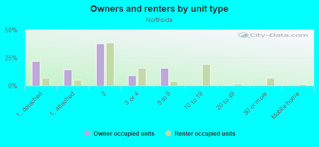
Owner-occupied
Renter-occupied

- Rooms in owner-occupied houses and condos in Northside
- 01 room
- 02 rooms
- 5543 rooms
- 6214 rooms
- 7725 rooms
- 4886 rooms
- 4337 rooms
- 3538 rooms
- 5029+ rooms
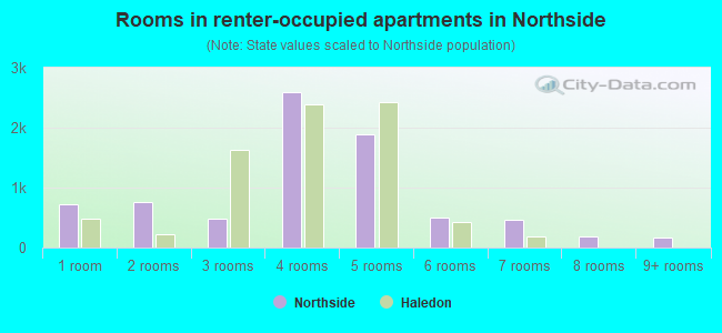
- Rooms in renter-occupied apartments in Northside
- 7131 room
- 7562 rooms
- 4883 rooms
- 2,5974 rooms
- 1,8925 rooms
- 4976 rooms
- 4627 rooms
- 1838 rooms
- 1689+ rooms
Owner-occupied
Renter-occupied
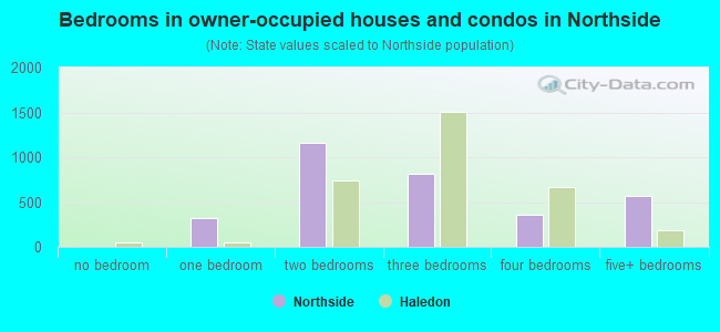
- Bedrooms in owner-occupied houses and condos in Northside
- 0no bedroom
- 3191 bedroom
- 1,1552 bedrooms
- 8103 bedrooms
- 3524 bedrooms
- 5625+ bedrooms
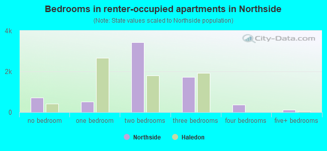
- Bedrooms in renter-occupied apartments in Northside
- 713no bedroom
- 5101 bedroom
- 3,4342 bedrooms
- 1,7243 bedrooms
- 3714 bedrooms
- 1345+ bedrooms
Average number of cars or other vehicles available in houses/condos:
Average number of cars or other vehicles available in apartments:
| This neighborhood: | 2.3 |
| Haledon: | 2.3 |
Average number of cars or other vehicles available in apartments:
| Here: | 1.1 |
| borough: | 1.1 |
Percentage of units with a mortgage:
| Northside: | 59.4% |
| Haledon: | 70.7% |
Housing prices:
- Average estimated value of detached houses in 2022 (15.5% of all units):
Northside: $371,262 New Jersey: $537,591
- Average estimated value of housing units in 2-unit structures in 2022 (56.3% of all units):
This neighborhood: $344,138 New Jersey: $444,476
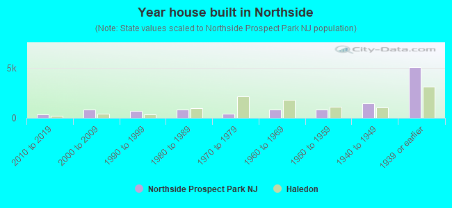
- Year house built in Northside
- 02020 or later
- 3212010 to 2019
- 8232000 to 2009
- 6931990 to 1999
- 8001980 to 1989
- 3881970 to 1979
- 8051960 to 1969
- 8501950 to 1959
- 1,4391940 to 1949
- 5,0221939 or earlier
City-data.com crime index for borough in 2020 (higher means more crime):
| City: | 117.5 |
| U.S. average: | 219.5 |
Travel time to work (commute)
![Travel time to work (commute)]()
- 188Less than 5 minutes
- 7525 to 9 minutes
- 1,34510 to 14 minutes
- 1,90915 to 19 minutes
- 2,20620 to 24 minutes
- 1,15125 to 29 minutes
- 2,24030 to 34 minutes
- 34035 to 39 minutes
- 7940 to 44 minutes
- 1,02345 to 59 minutes
- 26260 to 89 minutes
- 43090 or more minutes

Means of transportation to work
![Means of transportation to work]()
- 69.9%7,604Drove a car alone
- 16.4%1,788Carpooled
- 6.0%656Bus
- 7.3%793Long-distance train or commuter rail
- 7.7%841Taxi
- 8.8%962Walked
- 9.6%1,049Other means
- 8.6%940Worked at home

Time leaving home to go to work
![Time leaving home to go to work]()
- 23412:00 a.m. to 4:59 a.m.
- 1045:00 a.m. to 5:29 a.m.
- 3035:30 a.m. to 5:59 a.m.
- 1,1746:00 a.m. to 6:29 a.m.
- 2,0196:30 a.m. to 6:59 a.m.
- 1,0677:00 a.m. to 7:29 a.m.
- 1,5517:30 a.m. to 7:59 a.m.
- 2,7448:00 a.m. to 8:29 a.m.
- 5898:30 a.m. to 8:59 a.m.
- 5399:00 a.m. to 9:59 a.m.
- 39410:00 a.m. to 10:59 a.m.
- 12811:00 a.m. to 11:59 a.m.
- 36412:00 p.m. to 3:59 p.m.
- 4744:00 p.m. to 11:59 p.m.

Occupations of males:
- Percentage of males in management occupations (except farmers):
Here: 5.6% borough: 14.1%
- Percentage of males in business and financial operations occupations:
Here: 2.7% borough: 0.3%
- Percentage of males in architecture and engineering occupations:
Here: 1.7% borough: 0.4%
- Percentage of males in healthcare practitioners and technical occupations:
Here: 1.8% borough: 0.4%
- Percentage of males in service occupations:
Here: 9.5% borough: 16.3%
- Percentage of males in sales and office occupations:
Here: 23.4% borough: 12.6%
- Percentage of males in construction, extraction, and maintenance occupations:
Here: 10.1% borough: 7.8%
- Percentage of males in production occupations:
Here: 8.3% borough: 7.4%
- Percentage of males in transportation occupations:
Here: 16.1% borough: 11.4%
- Percentage of males in material moving occupations:
Here: 8.7% borough: 8.3%
Occupations of females:
- Percentage of females in management occupations (except farmers):
Here: 5.5% borough: 12.8%
- Percentage of females in community and social services occupations:
Here: 2.0% borough: 0.0%
- Percentage of females in education, training, and library occupations:
Here: 10.3% borough: 9.3%
- Percentage of females in healthcare practitioners and technical occupations:
Here: 6.1% borough: 5.6%
- Percentage of females in service occupations:
Here: 30.4% borough: 17.4%
- Percentage of females in sales and office occupations:
Here: 28.6% borough: 35.7%
- Percentage of females in production occupations:
Here: 10.8% borough: 3.6%
- Percentage of females in transportation occupations:
Here: 2.7% borough: 0.6%
- Percentage of females in material moving occupations:
Here: 1.9% borough: 3.4%
Education in this neighborhood (subdivision or community):
- Percentage of people 3 years and older in K-12 schools:
Northside: 31.3% Haledon: 15.5%
- Percentage of people 3 years and older in undergraduate colleges:
Northside: 5.4% Haledon: 5.8%
- Percentage of people 3 years and older in grad. or professional schools:
Northside: 1.3% Haledon: 0.7%
- Percentage of students K-12 enrolled in private schools:
Northside: 54.2% Haledon: 2.2%
Percentage of population below poverty level:
| Northside: | 23.6% |
| Haledon: | 8.5% |
Median year renter moved in (as recorded in 2022):
| Northside: | 2012 |
| Haledon: | 2014 |
Percentage of married-couple families with both working:
| Northside: | 64.0% |
| Haledon: | 80.8% |
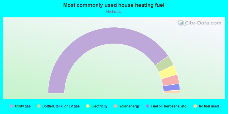
- 80.9%Utility gas
- 5.0%Bottled, tank, or LP gas
- 4.8%Electricity
- 4.6%Solar energy
- 3.2%Fuel oil, kerosene, etc.
- 1.4%No fuel used
Highways in this neighborhood:
Haledon Ave (State Rte 504)
Length: 1.29 miles
Direction: SE-NW
Address range: 1 to 466
Direction: SE-NW
Address range: 1 to 466
E Main St (State Rte 504)
Length: 0.62 miles
Directions: N-S, SW-NE
Address range: 1 to 271
Directions: N-S, SW-NE
Address range: 1 to 271
Goffle Rd (State Rte 504)
Length: 0.46 miles
Directions: N-S, SW-NE
Address range: 1 to 189
Directions: N-S, SW-NE
Address range: 1 to 189
State Rte 509 (Holsman St)
Length: 0.27 miles
Directions: N-S, SW-NE
Address range: 1 to 199
Directions: N-S, SW-NE
Address range: 1 to 199
Wagaraw Rd (State Rte 504)
Length: 0.19 miles
Direction: SW-NE
Address range: 1 to 60
Direction: SW-NE
Address range: 1 to 60
State Rte 504 (N Straight St)
Length: 0.12 miles
Directions: E-W, SE-NW
Address range: 38 to 73
Directions: E-W, SE-NW
Address range: 38 to 73
Roads and streets:
N 8th St
Length: 1.41 miles
Directions: E-W, SW-NE
Address range: 1 to 416
Directions: E-W, SW-NE
Address range: 1 to 416
N 9th St
Length: 1.23 miles
Directions: E-W, SW-NE
Address range: 1 to 428
Directions: E-W, SW-NE
Address range: 1 to 428
N 7th St
Length: 1.23 miles
Directions: E-W, N-S, SW-NE
Address range: 1 to 398
Directions: E-W, N-S, SW-NE
Address range: 1 to 398
N 10th St
Length: 1.15 miles
Directions: E-W, SW-NE
Address range: 1 to 436
Directions: E-W, SW-NE
Address range: 1 to 436
Clinton St
Length: 1.12 miles
Direction: SE-NW
Address range: 2 to 420
Direction: SE-NW
Address range: 2 to 420
N 11th St
Length: 1.06 miles
Directions: E-W, SW-NE
Address range: 1 to 448
Directions: E-W, SW-NE
Address range: 1 to 448
N 6th St
Length: 0.85 miles
Directions: E-W, SE-NW, SW-NE
Address range: 1 to 345
Directions: E-W, SE-NW, SW-NE
Address range: 1 to 345
Jefferson St
Length: 0.84 miles
Direction: SE-NW
Address range: 1 to 399
Direction: SE-NW
Address range: 1 to 399
N 12th St
Length: 0.81 miles
Directions: E-W, SW-NE
Address range: 1 to 199
Directions: E-W, SW-NE
Address range: 1 to 199
N 4th St
Length: 0.81 miles
Directions: E-W, SW-NE
Address range: 2 to 299
Directions: E-W, SW-NE
Address range: 2 to 299
Brown Ave
Length: 0.81 miles
Direction: SE-NW
Address range: 1 to 299
Direction: SE-NW
Address range: 1 to 299
Fairview Ave
Length: 0.80 miles
Direction: SE-NW
Address range: 1 to 299
Direction: SE-NW
Address range: 1 to 299
N 13th St
Length: 0.77 miles
Directions: E-W, SW-NE
Address range: 1 to 199
Directions: E-W, SW-NE
Address range: 1 to 199
Temple St
Length: 0.75 miles
Direction: SE-NW
Address range: 50 to 261
Direction: SE-NW
Address range: 50 to 261
N 15th St
Length: 0.66 miles
Directions: E-W, SW-NE
Address range: 1 to 230
Directions: E-W, SW-NE
Address range: 1 to 230
N 1st St
Length: 0.63 miles
Directions: E-W, SW-NE
Address range: 1 to 226
Directions: E-W, SW-NE
Address range: 1 to 226
Passaic County 662 (Burhans Ave)
Length: 0.61 miles
Direction: SW-NE
Address range: 127 to 329
Direction: SW-NE
Address range: 127 to 329
N 14th St
Length: 0.54 miles
Directions: E-W, SW-NE
Address range: 1 to 146
Directions: E-W, SW-NE
Address range: 1 to 146
N 16th St
Length: 0.54 miles
Directions: E-W, SW-NE
Address range: 1 to 135
Directions: E-W, SW-NE
Address range: 1 to 135
N 5th St
Length: 0.53 miles
Direction: SW-NE
Address range: 1 to 177
Direction: SW-NE
Address range: 1 to 177
Belmont Ave (Passaic County 675)
Length: 0.52 miles
Directions: N-S, SE-NW, SW-NE
Address range: 26 to 212
Directions: N-S, SE-NW, SW-NE
Address range: 26 to 212
N 3rd St
Length: 0.51 miles
Direction: SW-NE
Address range: 2 to 399
Direction: SW-NE
Address range: 2 to 399
Presidential Blvd
Length: 0.50 miles
Directions: E-W, N-S, SE-NW, SW-NE
Address range: 128 to 314
Directions: E-W, N-S, SE-NW, SW-NE
Address range: 128 to 314
Westervelt Ave
Length: 0.50 miles
Directions: N-S, SE-NW
Address range: 1 to 199
Directions: N-S, SE-NW
Address range: 1 to 199
Prescott Ave
Length: 0.48 miles
Directions: N-S, SE-NW
Address range: 1 to 216
Directions: N-S, SE-NW
Address range: 1 to 216
Mohawk Ave
Length: 0.47 miles
Direction: SE-NW
Address range: 1 to 199
Direction: SE-NW
Address range: 1 to 199
N 17th St
Length: 0.44 miles
Directions: E-W, N-S, SW-NE
Address range: 1 to 146
Directions: E-W, N-S, SW-NE
Address range: 1 to 146
N Main St
Length: 0.43 miles
Direction: SW-NE
Address range: 28 to 209
Direction: SW-NE
Address range: 28 to 209
Oxford St
Length: 0.43 miles
Directions: N-S, SE-NW, SW-NE
Address range: 1 to 175
Directions: N-S, SE-NW, SW-NE
Address range: 1 to 175
Planten Ave
Length: 0.41 miles
Direction: SE-NW
Address range: 1 to 118
Direction: SE-NW
Address range: 1 to 118
Roe St
Length: 0.40 miles
Direction: SE-NW
Address range: 15 to 441
Direction: SE-NW
Address range: 15 to 441
N 2nd St
Length: 0.40 miles
Direction: SW-NE
Address range: 1 to 150
Direction: SW-NE
Address range: 1 to 150
Struyk Ave
Length: 0.39 miles
Directions: E-W, N-S, SE-NW, SW-NE
Address range: 1 to 140
Directions: E-W, N-S, SE-NW, SW-NE
Address range: 1 to 140
Lily St
Length: 0.36 miles
Directions: E-W, SE-NW
Address range: 87 to 299
Directions: E-W, SE-NW
Address range: 87 to 299
Carbon St
Length: 0.34 miles
Direction: SE-NW
Address range: 79 to 213
Direction: SE-NW
Address range: 79 to 213
Cliff St
Length: 0.31 miles
Directions: E-W, N-S, SE-NW, SW-NE
Address range: 11 to 132
Directions: E-W, N-S, SE-NW, SW-NE
Address range: 11 to 132
Lake Shore Dr
Length: 0.29 miles
Directions: E-W, N-S, SW-NE
Address range: 1 to 99
Directions: E-W, N-S, SW-NE
Address range: 1 to 99
Hopper St
Length: 0.29 miles
Direction: SW-NE
Address range: 1 to 199
Direction: SW-NE
Address range: 1 to 199
Arch St
Length: 0.28 miles
Direction: SE-NW
Address range: 1 to 99
Direction: SE-NW
Address range: 1 to 99
Garfield Ave
Length: 0.28 miles
Direction: SW-NE
Address range: 1 to 99
Direction: SW-NE
Address range: 1 to 99
Wagaraw Blvd
Length: 0.26 miles
Direction: SW-NE
Address range: 1 to 99
Direction: SW-NE
Address range: 1 to 99
N 12th Pl
Length: 0.25 miles
Directions: E-W, SW-NE
Address range: 213 to 318
Directions: E-W, SW-NE
Address range: 213 to 318
Aberdeen Ct
Length: 0.24 miles
Directions: E-W, N-S, SE-NW, SW-NE
Address range: 1 to 100
Directions: E-W, N-S, SE-NW, SW-NE
Address range: 1 to 100
Zabriskie St
Length: 0.23 miles
Direction: SW-NE
Address range: 14 to 99
Direction: SW-NE
Address range: 14 to 99
Bergen St
Length: 0.23 miles
Directions: E-W, SE-NW
Address range: 1 to 75
Directions: E-W, SE-NW
Address range: 1 to 75
Bernard Ave
Length: 0.22 miles
Direction: SE-NW
Address range: 1 to 84
Direction: SE-NW
Address range: 1 to 84
John St
Length: 0.21 miles
Direction: SW-NE
Address range: 1 to 46
Direction: SW-NE
Address range: 1 to 46
Ida St
Length: 0.20 miles
Direction: SE-NW
Address range: 1 to 71
Direction: SE-NW
Address range: 1 to 71
N 13th Pl
Length: 0.20 miles
Directions: E-W, SW-NE
Address range: 234 to 316
Directions: E-W, SW-NE
Address range: 234 to 316
Halpine St
Length: 0.19 miles
Direction: SE-NW
Address range: 10 to 80
Direction: SE-NW
Address range: 10 to 80
Post St
Length: 0.19 miles
Direction: SE-NW
Address range: 1 to 69
Direction: SE-NW
Address range: 1 to 69
Matlock St
Length: 0.19 miles
Direction: SW-NE
Address range: 1 to 3
Direction: SW-NE
Address range: 1 to 3
Hillman St
Length: 0.19 miles
Direction: E-W
Address range: 3 to 61
Direction: E-W
Address range: 3 to 61
E Barbour St
Length: 0.18 miles
Direction: SW-NE
Address range: 1 to 74
Direction: SW-NE
Address range: 1 to 74
E Holsman St
Length: 0.17 miles
Direction: E-W
Address range: 100 to 165
Direction: E-W
Address range: 100 to 165
Watson St (E Halden Ave)
Length: 0.15 miles
Direction: E-W
Address range: 1 to 54
Direction: E-W
Address range: 1 to 54
Cook St
Length: 0.15 miles
Direction: SW-NE
Address range: 1 to 48
Direction: SW-NE
Address range: 1 to 48
Lee Ave
Length: 0.15 miles
Direction: SE-NW
Address range: 1 to 50
Direction: SE-NW
Address range: 1 to 50
Cona Ct
Length: 0.14 miles
Directions: N-S, SE-NW, SW-NE
Address range: 1 to 56
Directions: N-S, SE-NW, SW-NE
Address range: 1 to 56
Sandy Ct
Length: 0.13 miles
Direction: SW-NE
Address range: 1 to 134
Direction: SW-NE
Address range: 1 to 134
Lupton Ln
Length: 0.12 miles
Directions: N-S, SE-NW
Address range: 52 to 98
Directions: N-S, SE-NW
Address range: 52 to 98
Geyer St
Length: 0.12 miles
Direction: SE-NW
Address range: 1 to 56
Direction: SE-NW
Address range: 1 to 56
N Bridge St
Length: 0.11 miles
Direction: N-S
Address range: 1 to 50
Direction: N-S
Address range: 1 to 50
Stout St
Length: 0.11 miles
Directions: E-W, SE-NW
Address range: 1 to 46
Directions: E-W, SE-NW
Address range: 1 to 46
Belle Ave
Length: 0.11 miles
Direction: SE-NW
Address range: 1 to 99
Direction: SE-NW
Address range: 1 to 99
Park Entrance
Length: 0.11 miles
Directions: E-W, SE-NW
Address range: 314 to 323
Directions: E-W, SE-NW
Address range: 314 to 323
Halsey Ave
Length: 0.11 miles
Direction: SW-NE
Direction: SW-NE
Circle Ave
Length: 0.11 miles
Direction: N-S
Address range: 1 to 35
Direction: N-S
Address range: 1 to 35
Savoy Pl
Length: 0.10 miles
Direction: E-W
Address range: 1 to 99
Direction: E-W
Address range: 1 to 99
N 15th Pl (15th St)
Length: 0.10 miles
Directions: E-W, SW-NE
Address range: 294 to 399
Directions: E-W, SW-NE
Address range: 294 to 399
Haldon St (N Straight St)
Length: 0.09 miles
Directions: E-W, SE-NW
Address range: 1 to 30
Directions: E-W, SE-NW
Address range: 1 to 30
Piercy St
Length: 0.09 miles
Direction: SE-NW
Address range: 1 to 44
Direction: SE-NW
Address range: 1 to 44
Amity St
Length: 0.09 miles
Direction: E-W
Address range: 1 to 31
Direction: E-W
Address range: 1 to 31
Prescott Pl
Length: 0.09 miles
Directions: N-S, SE-NW, SW-NE
Address range: 1 to 38
Directions: N-S, SE-NW, SW-NE
Address range: 1 to 38
Barnert Pl
Length: 0.08 miles
Direction: SE-NW
Address range: 1 to 30
Direction: SE-NW
Address range: 1 to 30
Prescott Ter
Length: 0.08 miles
Directions: E-W, SW-NE
Address range: 271 to 302
Directions: E-W, SW-NE
Address range: 271 to 302
Christopher Columbus Dr
Length: 0.08 miles
Direction: SE-NW
Direction: SE-NW
Inglis Pl
Length: 0.08 miles
Direction: SE-NW
Address range: 1 to 13
Direction: SE-NW
Address range: 1 to 13
Jay St
Length: 0.08 miles
Directions: SE-NW, SW-NE
Directions: SE-NW, SW-NE
Hudson St
Length: 0.07 miles
Direction: SE-NW
Address range: 1 to 32
Direction: SE-NW
Address range: 1 to 32
Short St
Length: 0.07 miles
Direction: E-W
Address range: 1 to 17
Direction: E-W
Address range: 1 to 17
Irvington
Length: 0.06 miles
Directions: E-W, N-S, SE-NW, SW-NE
Address range: 28 to 53
Directions: E-W, N-S, SE-NW, SW-NE
Address range: 28 to 53
Haledon St (N Straight St, Bishop Clarence Gilmore Plz)
Length: 0.06 miles
Directions: E-W, SE-NW
Address range: 31 to 51
Directions: E-W, SE-NW
Address range: 31 to 51
Welcome St
Length: 0.06 miles
Direction: SE-NW
Direction: SE-NW
Arlington St
Length: 0.06 miles
Direction: SW-NE
Address range: 1 to 99
Direction: SW-NE
Address range: 1 to 99
Lambert Pl
Length: 0.05 miles
Direction: SE-NW
Direction: SE-NW
Kenneth Ave
Length: 0.05 miles
Direction: SE-NW
Address range: 63 to 98
Direction: SE-NW
Address range: 63 to 98
Park Ave
Length: 0.05 miles
Direction: SE-NW
Address range: 1 to 3
Direction: SE-NW
Address range: 1 to 3
Cyril Ave
Length: 0.05 miles
Direction: SE-NW
Address range: 83 to 136
Direction: SE-NW
Address range: 83 to 136
Reenstra Ct
Length: 0.04 miles
Direction: SW-NE
Direction: SW-NE
Cyril Dr
Length: 0.04 miles
Direction: SE-NW
Direction: SE-NW
Stams Aly
Length: 0.04 miles
Direction: SE-NW
Address range: 1 to 99
Direction: SE-NW
Address range: 1 to 99
Passaic County 652
Length: 0.04 miles
Direction: E-W
Direction: E-W
Hope St
Length: 0.03 miles
Direction: SW-NE
Address range: 39 to 98
Direction: SW-NE
Address range: 39 to 98
Watson St
Length: 0.03 miles
Direction: E-W
Direction: E-W
Arch St Brg
Length: 0.02 miles
Direction: SE-NW
Direction: SE-NW
Other features:
Molly Ann Brk
Length: 0.51 miles
Directions: N-S, SW-NE
Directions: N-S, SW-NE
Goffle Brk
Length: 0.04 miles
Directions: E-W, SE-NW
Directions: E-W, SE-NW