Pennypack neighborhood in Philadelphia, Pennsylvania (PA), 19114, 19136, 19152 detailed profile
Settings
X


Business Search - 14 Million verified businesses
Area: 3.017 square miles
Population: 23,339
Population density:
| Pennypack: | 7,736 people per square mile |
| Philadelphia: | 11,602 people per square mile |

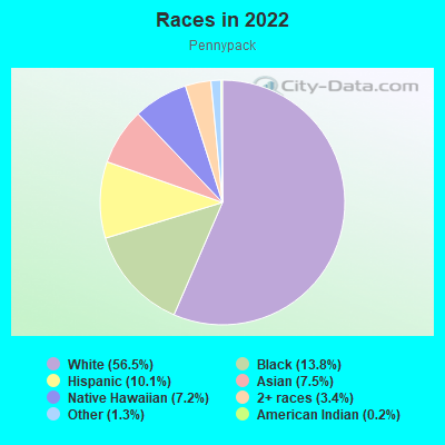
- 15,36356.5%White
- 3,74913.8%Black
- 2,74210.1%Hispanic or Latino
- 2,0407.5%Asian
- 1,9677.2%Native Hawaiian and Other
Pacific Islander - 9143.4%Two or more races
- 3521.3%Some other race
- 470.2%American Indian
Distribution of median household income
![Distribution of median household income]()
- 423Less than $10,000
- 1,908$10,000 to $19,999
- 965$20,000 to $29,999
- 1,476$30,000 to $39,999
- 931$40,000 to $49,999
- 740$50,000 to $59,999
- 1,123$60,000 to $74,999
- 1,259$75,000 to $99,999
- 861$100,000 to $124,999
- 1,259$125,000 to $149,999
- 925$150,000 to $199,999
- 957$200,000 or more

Distribution of owner-occupied house/condo value
![Distribution of owner-occupied house/condo value]()
- 2,828Less than $50,000
- 1,834$50,000 to $99,999
- 611$100,000 to $149,999
- 1,426$150,000 to $199,999
- 2,008$200,000 to $249,999
- 2,605$250,000 to $299,999
- 1,808$300,000 to $399,999
- 387$400,000 to $499,999
- 309$500,000 to $749,999
- 129$750,000 to $999,999
- 440$1,000,000 or more

Distribution of rent paid by renters
![Distribution of rent paid by renters]()
- 608Less than $100
- 55$100 to $199
- 33$200 to $299
- 1,060$300 to $399
- 568$400 to $499
- 1,379$500 to $599
- 778$600 to $699
- 3,176$700 to $799
- 2,140$800 to $899
- 616$900 to $999
- 1,579$1,000 to $1,249
- 1,124$1,250 to $1,499
- 1,020$1,500 to $1,999
- 397$2,000 or more

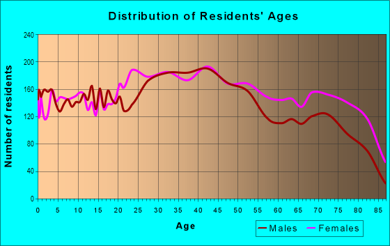
| Males: | 11,361 |
| Females: | 11,978 |
Males:
| This neighborhood: | 39.9 years |
| Whole city: | 34.1 years |
| This neighborhood: | 43.0 years |
| Whole city: | 36.3 years |
Average household size:
| Pennypack: | 9.3 people |
| Philadelphia: | 2.2 people |
Percentage of family households:
| Pennypack: | 41.1% |
| Philadelphia: | 36.5% |
| Here: | 44.6% |
| Philadelphia: | 28.0% |
Percentage of married-couple families with children (among all households):
| Pennypack: | 29.4% |
| Philadelphia: | 23.5% |
Percentage of single-mother households (among all households):
| Pennypack: | 12.9% |
| Philadelphia: | 17.6% |
Percentage of never married males 15 years old and over:
Percentage of never married females 15 years old and over:
| Pennypack: | 18.6% |
| Philadelphia: | 23.9% |
Percentage of never married females 15 years old and over:
| Pennypack: | 13.4% |
| city: | 26.0% |
Percentage of people that speak English not well or not at all:
| Pennypack: | 4.9% |
| Philadelphia: | 7.0% |
Percentage of people born in this state:
Percentage of people born in another U.S. state:
Percentage of native residents but born outside the U.S.:
Percentage of foreign born residents:
| Here: | 71.5% |
| Philadelphia: | 61.6% |
Percentage of people born in another U.S. state:
| Pennypack: | 8.2% |
| Philadelphia: | 18.9% |
Percentage of native residents but born outside the U.S.:
| Here: | 5.0% |
| city: | 3.7% |
Percentage of foreign born residents:
| Here: | 15.3% |
| Philadelphia: | 15.7% |
Owner-occupied
Renter-occupied


- Rooms in owner-occupied houses and condos in Pennypack
- 01 room
- 2692 rooms
- 2233 rooms
- 6074 rooms
- 8825 rooms
- 1,5916 rooms
- 1,8987 rooms
- 9458 rooms
- 1,1999+ rooms

- Rooms in renter-occupied apartments in Pennypack
- 1,2461 room
- 3172 rooms
- 9533 rooms
- 1,3724 rooms
- 8705 rooms
- 1,8076 rooms
- 4617 rooms
- 1688 rooms
- 3129+ rooms
Owner-occupied
Renter-occupied

- Bedrooms in owner-occupied houses and condos in Pennypack
- 84no bedroom
- 2361 bedroom
- 7682 bedrooms
- 4,3433 bedrooms
- 1,4764 bedrooms
- 5885+ bedrooms
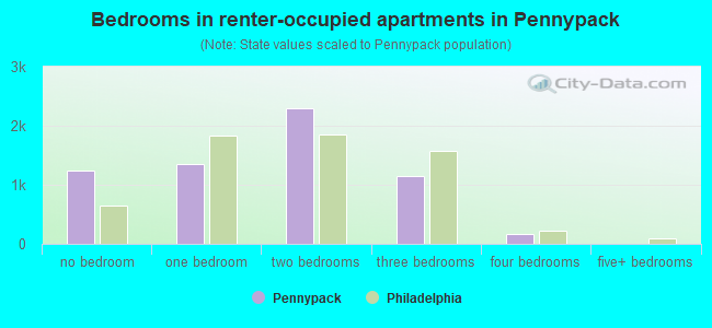
- Bedrooms in renter-occupied apartments in Pennypack
- 1,246no bedroom
- 1,3571 bedroom
- 2,3032 bedrooms
- 1,1423 bedrooms
- 1584 bedrooms
- 05+ bedrooms
Average number of cars or other vehicles available in houses/condos:
Average number of cars or other vehicles available in apartments:
| This neighborhood: | 1.7 |
| Philadelphia: | 1.3 |
Average number of cars or other vehicles available in apartments:
| Here: | |
| city: |
Percentage of units with a mortgage:
| Pennypack: | 60.7% |
| Philadelphia: | 58.9% |
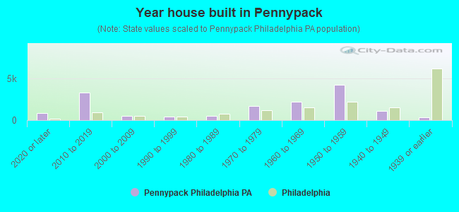
- Year house built in Pennypack
- 8252020 or later
- 3,2962010 to 2019
- 5082000 to 2009
- 4661990 to 1999
- 5291980 to 1989
- 1,7031970 to 1979
- 2,2291960 to 1969
- 4,2511950 to 1959
- 1,1391940 to 1949
- 3711939 or earlier
City-data.com crime index for city in 2020 (higher means more crime):
| City: | 169.8 |
| U.S. average: | 219.5 |
Travel time to work (commute)
![Travel time to work (commute)]()
- 223Less than 5 minutes
- 7255 to 9 minutes
- 1,32610 to 14 minutes
- 1,28315 to 19 minutes
- 1,38320 to 24 minutes
- 85125 to 29 minutes
- 1,62630 to 34 minutes
- 33035 to 39 minutes
- 88940 to 44 minutes
- 1,71445 to 59 minutes
- 95760 to 89 minutes
- 50390 or more minutes

Means of transportation to work
![Means of transportation to work]()
- 73.3%8,246Drove a car alone
- 9.7%1,093Carpooled
- 5.7%637Bus
- 2.7%307Subway or elevated rail
- 3.5%389Long-distance train or commuter rail
- 2.7%301Light rail, streetcar or trolley
- 5.0%562Taxi
- 0.7%78Motorcycle
- 3.6%403Bicycle
- 1.8%207Walked
- 4.3%482Other means
- 9.9%1,112Worked at home

Time leaving home to go to work
![Time leaving home to go to work]()
- 45812:00 a.m. to 4:59 a.m.
- 6145:00 a.m. to 5:29 a.m.
- 7865:30 a.m. to 5:59 a.m.
- 1,1646:00 a.m. to 6:29 a.m.
- 7596:30 a.m. to 6:59 a.m.
- 1,5337:00 a.m. to 7:29 a.m.
- 1,0157:30 a.m. to 7:59 a.m.
- 1,1238:00 a.m. to 8:29 a.m.
- 4278:30 a.m. to 8:59 a.m.
- 4169:00 a.m. to 9:59 a.m.
- 77310:00 a.m. to 10:59 a.m.
- 30011:00 a.m. to 11:59 a.m.
- 1,13312:00 p.m. to 3:59 p.m.
- 1,1364:00 p.m. to 11:59 p.m.

Occupations of males:
- Percentage of males in management occupations (except farmers):
Here: 12.1% city: 9.1%
- Percentage of males in business and financial operations occupations:
Here: 4.7% city: 6.0%
- Percentage of males in computer and mathematical occupations:
Here: 2.0% city: 4.6%
- Percentage of males in community and social services occupations:
Here: 1.1% city: 1.9%
- Percentage of males in legal occupations:
Here: 1.8% city: 1.8%
- Percentage of males in arts, design, entertainment, sports, and media occupations:
Here: 2.9% city: 2.5%
- Percentage of males in healthcare practitioners and technical occupations:
Here: 2.8% city: 4.3%
- Percentage of males in service occupations:
Here: 18.4% city: 19.3%
- Percentage of males in sales and office occupations:
Here: 14.2% city: 14.1%
- Percentage of males in construction, extraction, and maintenance occupations:
Here: 11.2% city: 6.4%
- Percentage of males in production occupations:
Here: 5.5% city: 5.0%
- Percentage of males in transportation occupations:
Here: 9.4% city: 6.9%
- Percentage of males in material moving occupations:
Here: 8.4% city: 6.2%
Occupations of females:
- Percentage of females in management occupations (except farmers):
Here: 9.7% city: 9.1%
- Percentage of females in business and financial operations occupations:
Here: 8.3% city: 6.6%
- Percentage of females in computer and mathematical occupations:
Here: 2.5% city: 1.7%
- Percentage of females in life, physical, and social science occupations:
Here: 2.9% city: 1.6%
- Percentage of females in community and social services occupations:
Here: 2.3% city: 3.6%
- Percentage of females in legal occupations:
Here: 2.4% city: 1.9%
- Percentage of females in education, training, and library occupations:
Here: 4.7% city: 8.5%
- Percentage of females in arts, design, entertainment, sports, and media occupations:
Here: 2.8% city: 2.4%
- Percentage of females in healthcare practitioners and technical occupations:
Here: 11.4% city: 10.3%
- Percentage of females in service occupations:
Here: 21.9% city: 24.4%
- Percentage of females in sales and office occupations:
Here: 24.0% city: 23.4%
- Percentage of females in production occupations:
Here: 3.0% city: 2.4%
- Percentage of females in transportation occupations:
Here: 1.7% city: 1.1%
- Percentage of females in material moving occupations:
Here: 1.7% city: 1.7%
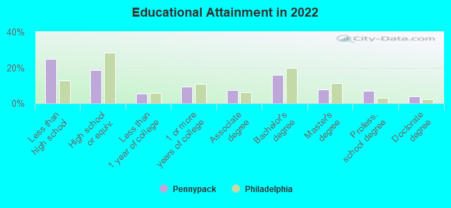
Education in this neighborhood (subdivision or community):
- Percentage of people 3 years and older in K-12 schools:
Pennypack: 25.3% Philadelphia: 15.6%
- Percentage of people 3 years and older in undergraduate colleges:
Pennypack: 5.5% Philadelphia: 6.0%
- Percentage of people 3 years and older in grad. or professional schools:
Pennypack: 7.2% Philadelphia: 2.8%
- Percentage of students K-12 enrolled in private schools:
Pennypack: 67.7% Philadelphia: 25.0%
Percentage of population below poverty level:
| Pennypack: | 9.4% |
| Philadelphia: | 21.7% |
Median year owner moved in (as recorded in 2022):
| Pennypack: | 2003 |
| Philadelphia: | 2007 |
Percentage of married-couple families with both working:
| Pennypack: | 79.1% |
| Philadelphia: | 71.4% |
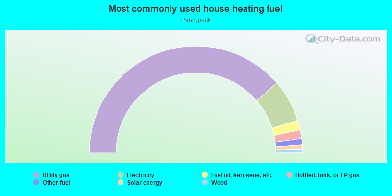
- 77.4%Utility gas
- 12.8%Electricity
- 3.0%Fuel oil, kerosene, etc.
- 2.6%Bottled, tank, or LP gas
- 1.8%Other fuel
- 1.5%Solar energy
- 1.0%Wood
Highways in this neighborhood:
Holme Ave
Length: 3.41 miles
Directions: E-W, SW-NE
Address range: 2801 to 3399
Directions: E-W, SW-NE
Address range: 2801 to 3399
Grant Ave
Length: 2.17 miles
Directions: E-W, SE-NW
Address range: 2314 to 3999
Directions: E-W, SE-NW
Address range: 2314 to 3999
Willits Rd
Length: 1.79 miles
Directions: E-W, SE-NW
Address range: 2601 to 3698
Directions: E-W, SE-NW
Address range: 2601 to 3698
Welsh Rd
Length: 1.72 miles
Directions: N-S, SE-NW, SW-NE
Address range: 2300 to 3199
Directions: N-S, SE-NW, SW-NE
Address range: 2300 to 3199
Frankford Ave (US Hwy 13)
Length: 1.35 miles
Directions: E-W, SW-NE
Address range: 9100 to 9799
Directions: E-W, SW-NE
Address range: 9100 to 9799
Academy Rd
Length: 1.20 miles
Directions: N-S, SW-NE
Address range: 9101 to 9499
Directions: N-S, SW-NE
Address range: 9101 to 9499
Roads and streets:
Roosevelt Blvd
Length: 2.85 miles
Direction: SW-NE
Address range: 8801 to 9099
Direction: SW-NE
Address range: 8801 to 9099
Ashton Rd
Length: 1.49 miles
Direction: SW-NE
Address range: 8600 to 9799
Direction: SW-NE
Address range: 8600 to 9799
Blue Grass Rd
Length: 1.15 miles
Directions: E-W, SW-NE
Address range: 8800 to 9499
Directions: E-W, SW-NE
Address range: 8800 to 9499
Convent Ave
Length: 1.14 miles
Directions: E-W, N-S, SE-NW, SW-NE
Address range: 8900 to 9699
Directions: E-W, N-S, SE-NW, SW-NE
Address range: 8900 to 9699
Tremont St
Length: 1.06 miles
Directions: E-W, N-S, SE-NW, SW-NE
Address range: 2601 to 3099
Directions: E-W, N-S, SE-NW, SW-NE
Address range: 2601 to 3099
Annapolis Rd
Length: 0.84 miles
Directions: E-W, N-S, SE-NW, SW-NE
Address range: 9200 to 9399
Directions: E-W, N-S, SE-NW, SW-NE
Address range: 9200 to 9399
Fordham Rd
Length: 0.79 miles
Directions: E-W, SE-NW, SW-NE
Address range: 3100 to 9599
Directions: E-W, SE-NW, SW-NE
Address range: 3100 to 9599
Primrose Rd
Length: 0.74 miles
Directions: E-W, SE-NW
Address range: 3200 to 3599
Directions: E-W, SE-NW
Address range: 3200 to 3599
Walnut Hill St
Length: 0.73 miles
Directions: E-W, N-S, SW-NE
Address range: 2700 to 2999
Directions: E-W, N-S, SW-NE
Address range: 2700 to 2999
Fitler St
Length: 0.68 miles
Directions: E-W, SE-NW, SW-NE
Address range: 3300 to 3999
Directions: E-W, SE-NW, SW-NE
Address range: 3300 to 3999
Pennypack St
Length: 0.68 miles
Directions: N-S, SE-NW
Address range: 3701 to 3982
Directions: N-S, SE-NW
Address range: 3701 to 3982
Revere St
Length: 0.67 miles
Directions: E-W, SE-NW, SW-NE
Address range: 8800 to 9199
Directions: E-W, SE-NW, SW-NE
Address range: 8800 to 9199
Winchester Ave
Length: 0.66 miles
Directions: E-W, SE-NW, SW-NE
Address range: 2500 to 2848
Directions: E-W, SE-NW, SW-NE
Address range: 2500 to 2848
Fairfield St
Length: 0.66 miles
Directions: E-W, N-S, SE-NW, SW-NE
Address range: 3000 to 8999
Directions: E-W, N-S, SE-NW, SW-NE
Address range: 3000 to 8999
Treaty Rd
Length: 0.64 miles
Directions: N-S, SE-NW
Address range: 9200 to 9399
Directions: N-S, SE-NW
Address range: 9200 to 9399
Maxwell St
Length: 0.62 miles
Directions: N-S, SE-NW
Address range: 2500 to 2899
Directions: N-S, SE-NW
Address range: 2500 to 2899
Outlook Ave
Length: 0.62 miles
Directions: E-W, SW-NE
Address range: 9101 to 9599
Directions: E-W, SW-NE
Address range: 9101 to 9599
Colfax St
Length: 0.61 miles
Direction: E-W
Address range: 8000 to 8299
Direction: E-W
Address range: 8000 to 8299
Andover Rd
Length: 0.60 miles
Direction: N-S
Address range: 9200 to 9399
Direction: N-S
Address range: 9200 to 9399
Kirkwood Rd
Length: 0.59 miles
Directions: E-W, N-S, SE-NW, SW-NE
Address range: 3400 to 9499
Directions: E-W, N-S, SE-NW, SW-NE
Address range: 3400 to 9499
Leon St
Length: 0.58 miles
Directions: E-W, N-S, SE-NW, SW-NE
Address range: 9200 to 9799
Directions: E-W, N-S, SE-NW, SW-NE
Address range: 9200 to 9799
Dewees St
Length: 0.55 miles
Directions: E-W, SW-NE
Address range: 8800 to 9299
Directions: E-W, SW-NE
Address range: 8800 to 9299
Albion St
Length: 0.55 miles
Directions: E-W, SE-NW, SW-NE
Address range: 8010 to 8299
Directions: E-W, SE-NW, SW-NE
Address range: 8010 to 8299
Crispin St (Crispin Dr)
Length: 0.54 miles
Direction: SW-NE
Address range: 8600 to 8899
Direction: SW-NE
Address range: 8600 to 8899
Lansford St
Length: 0.54 miles
Directions: E-W, N-S, SE-NW, SW-NE
Address range: 9200 to 9499
Directions: E-W, N-S, SE-NW, SW-NE
Address range: 9200 to 9499
Eden St
Length: 0.54 miles
Directions: E-W, SE-NW
Address range: 3200 to 3999
Directions: E-W, SE-NW
Address range: 3200 to 3999
Tolbut St
Length: 0.50 miles
Directions: E-W, N-S, SE-NW, SW-NE
Address range: 2601 to 2899
Directions: E-W, N-S, SE-NW, SW-NE
Address range: 2601 to 2899
Holyoke Rd
Length: 0.49 miles
Directions: E-W, N-S, SE-NW, SW-NE
Address range: 3025 to 3499
Directions: E-W, N-S, SE-NW, SW-NE
Address range: 3025 to 3499
Winthrop St
Length: 0.48 miles
Directions: E-W, N-S, SE-NW, SW-NE
Address range: 8100 to 8299
Directions: E-W, N-S, SE-NW, SW-NE
Address range: 8100 to 8299
Hargrave St
Length: 0.48 miles
Directions: E-W, N-S, SE-NW, SW-NE
Address range: 2800 to 8899
Directions: E-W, N-S, SE-NW, SW-NE
Address range: 2800 to 8899
Aubrey Ave
Length: 0.46 miles
Directions: E-W, SE-NW
Address range: 3400 to 3899
Directions: E-W, SE-NW
Address range: 3400 to 3899
Narvon St
Length: 0.46 miles
Directions: E-W, SE-NW, SW-NE
Address range: 8001 to 8299
Directions: E-W, SE-NW, SW-NE
Address range: 8001 to 8299
Crispin St
Length: 0.44 miles
Directions: E-W, N-S, SE-NW, SW-NE
Address range: 9100 to 9399
Directions: E-W, N-S, SE-NW, SW-NE
Address range: 9100 to 9399
Brous Ave
Length: 0.44 miles
Directions: E-W, SE-NW, SW-NE
Address range: 8800 to 9099
Directions: E-W, SE-NW, SW-NE
Address range: 8800 to 9099
Calvert St
Length: 0.44 miles
Directions: E-W, SW-NE
Address range: 8800 to 8999
Directions: E-W, SW-NE
Address range: 8800 to 8999
Wesleyan Rd
Length: 0.44 miles
Directions: E-W, N-S, SW-NE
Address range: 9000 to 9299
Directions: E-W, N-S, SW-NE
Address range: 9000 to 9299
Stamford St
Length: 0.43 miles
Directions: N-S, SE-NW, SW-NE
Address range: 2800 to 3180
Directions: N-S, SE-NW, SW-NE
Address range: 2800 to 3180
Holme Dr
Length: 0.41 miles
Direction: E-W
Address range: 8700 to 8899
Direction: E-W
Address range: 8700 to 8899
Woodenbridge Rd
Length: 0.41 miles
Directions: E-W, N-S, SE-NW, SW-NE
Address range: 9200 to 9299
Directions: E-W, N-S, SE-NW, SW-NE
Address range: 9200 to 9299
Cloverly Rd
Length: 0.40 miles
Directions: E-W, N-S, SE-NW, SW-NE
Address range: 9000 to 9399
Directions: E-W, N-S, SE-NW, SW-NE
Address range: 9000 to 9399
Linden Ave
Length: 0.37 miles
Directions: N-S, SE-NW
Address range: 3702 to 3999
Directions: N-S, SE-NW
Address range: 3702 to 3999
Woodward St
Length: 0.37 miles
Directions: E-W, N-S, SE-NW
Address range: 2600 to 8899
Directions: E-W, N-S, SE-NW
Address range: 2600 to 8899
Exeter Rd
Length: 0.36 miles
Directions: N-S, SW-NE
Address range: 9100 to 9299
Directions: N-S, SW-NE
Address range: 9100 to 9299
Woodbridge Rd
Length: 0.34 miles
Directions: E-W, N-S, SE-NW, SW-NE
Address range: 2800 to 9499
Directions: E-W, N-S, SE-NW, SW-NE
Address range: 2800 to 9499
E Roosevelt Blvd
Length: 0.34 miles
Directions: E-W, SE-NW, SW-NE
Directions: E-W, SE-NW, SW-NE
Stanwood St
Length: 0.33 miles
Directions: E-W, N-S, SE-NW, SW-NE
Address range: 3000 to 3199
Directions: E-W, N-S, SE-NW, SW-NE
Address range: 3000 to 3199
Pearson Ave
Length: 0.32 miles
Direction: SE-NW
Address range: 3500 to 3999
Direction: SE-NW
Address range: 3500 to 3999
Marshall St
Length: 0.31 miles
Directions: E-W, SW-NE
Address range: 9100 to 9299
Directions: E-W, SW-NE
Address range: 9100 to 9299
Draper St
Length: 0.31 miles
Directions: E-W, N-S, SE-NW, SW-NE
Address range: 3100 to 3199
Directions: E-W, N-S, SE-NW, SW-NE
Address range: 3100 to 3199
Campus Ln
Length: 0.30 miles
Directions: E-W, N-S, SE-NW
Address range: 9300 to 9399
Directions: E-W, N-S, SE-NW
Address range: 9300 to 9399
Manchester Ave
Length: 0.29 miles
Directions: E-W, N-S, SE-NW, SW-NE
Address range: 2776 to 8899
Directions: E-W, N-S, SE-NW, SW-NE
Address range: 2776 to 8899
Leonard St
Length: 0.27 miles
Directions: E-W, SE-NW, SW-NE
Address range: 8900 to 9099
Directions: E-W, SE-NW, SW-NE
Address range: 8900 to 9099
Brocklehurst St
Length: 0.27 miles
Directions: N-S, SW-NE
Address range: 8800 to 8999
Directions: N-S, SW-NE
Address range: 8800 to 8999
Macon St
Length: 0.27 miles
Directions: E-W, N-S, SE-NW, SW-NE
Address range: 8700 to 8899
Directions: E-W, N-S, SE-NW, SW-NE
Address range: 8700 to 8899
Ryerson Rd
Length: 0.26 miles
Directions: E-W, N-S, SE-NW, SW-NE
Address range: 9100 to 9199
Directions: E-W, N-S, SE-NW, SW-NE
Address range: 9100 to 9199
Angus Rd
Length: 0.24 miles
Directions: E-W, N-S, SE-NW, SW-NE
Address range: 2800 to 2899
Directions: E-W, N-S, SE-NW, SW-NE
Address range: 2800 to 2899
Clayton St
Length: 0.24 miles
Directions: E-W, N-S, SE-NW
Address range: 2700 to 2799
Directions: E-W, N-S, SE-NW
Address range: 2700 to 2799
Axe Factory Rd
Length: 0.23 miles
Direction: SE-NW
Address range: 2740 to 2899
Direction: SE-NW
Address range: 2740 to 2899
Lenola St
Length: 0.23 miles
Directions: E-W, SW-NE
Address range: 8000 to 8099
Directions: E-W, SW-NE
Address range: 8000 to 8099
Horatio Rd
Length: 0.23 miles
Directions: E-W, SW-NE
Address range: 9200 to 9299
Directions: E-W, SW-NE
Address range: 9200 to 9299
Stardust Ln
Length: 0.23 miles
Directions: E-W, SW-NE
Address range: 8600 to 8799
Directions: E-W, SW-NE
Address range: 8600 to 8799
Gregg St
Length: 0.22 miles
Direction: SE-NW
Address range: 2428 to 2498
Direction: SE-NW
Address range: 2428 to 2498
Shipley Rd
Length: 0.22 miles
Directions: E-W, SE-NW
Address range: 2800 to 2899
Directions: E-W, SE-NW
Address range: 2800 to 2899
Donaldson St
Length: 0.22 miles
Direction: SW-NE
Address range: 9131 to 9137
Direction: SW-NE
Address range: 9131 to 9137
Wilson St
Length: 0.21 miles
Directions: E-W, SE-NW
Address range: 8136 to 8299
Directions: E-W, SE-NW
Address range: 8136 to 8299
Hickory Dr
Length: 0.21 miles
Direction: SW-NE
Address range: 8600 to 8799
Direction: SW-NE
Address range: 8600 to 8799
Brookdale Rd
Length: 0.21 miles
Directions: E-W, SE-NW, SW-NE
Address range: 3200 to 3299
Directions: E-W, SE-NW, SW-NE
Address range: 3200 to 3299
Gelena Rd
Length: 0.20 miles
Directions: E-W, N-S, SE-NW, SW-NE
Address range: 2900 to 2999
Directions: E-W, N-S, SE-NW, SW-NE
Address range: 2900 to 2999
Taunton St
Length: 0.20 miles
Directions: E-W, SE-NW
Address range: 2600 to 2799
Directions: E-W, SE-NW
Address range: 2600 to 2799
Arendell Ave
Length: 0.20 miles
Directions: E-W, SE-NW
Address range: 3800 to 3899
Directions: E-W, SE-NW
Address range: 3800 to 3899
Michael Rd
Length: 0.20 miles
Directions: E-W, SE-NW
Address range: 2800 to 2899
Directions: E-W, SE-NW
Address range: 2800 to 2899
Joey Dr
Length: 0.19 miles
Directions: E-W, N-S, SW-NE
Address range: 2900 to 2999
Directions: E-W, N-S, SW-NE
Address range: 2900 to 2999
Martindale St
Length: 0.19 miles
Direction: E-W
Address range: 8100 to 8199
Direction: E-W
Address range: 8100 to 8199
Midland Ave
Length: 0.19 miles
Directions: E-W, SE-NW, SW-NE
Address range: 8600 to 8799
Directions: E-W, SE-NW, SW-NE
Address range: 8600 to 8799
Puritan Rd
Length: 0.19 miles
Directions: E-W, SW-NE
Address range: 9200 to 9299
Directions: E-W, SW-NE
Address range: 9200 to 9299
Weston St
Length: 0.19 miles
Direction: N-S
Address range: 3100 to 3199
Direction: N-S
Address range: 3100 to 3199
Perch Ln
Length: 0.18 miles
Directions: E-W, SW-NE
Address range: 8600 to 8799
Directions: E-W, SW-NE
Address range: 8600 to 8799
Etta St
Length: 0.17 miles
Direction: SE-NW
Address range: 3841 to 3899
Direction: SE-NW
Address range: 3841 to 3899
Janice St
Length: 0.17 miles
Directions: E-W, SE-NW, SW-NE
Address range: 3800 to 3899
Directions: E-W, SE-NW, SW-NE
Address range: 3800 to 3899
Marigold Pl
Length: 0.17 miles
Directions: E-W, SW-NE
Address range: 8600 to 8799
Directions: E-W, SW-NE
Address range: 8600 to 8799
Dartmouth Pl
Length: 0.16 miles
Directions: E-W, SE-NW
Address range: 3800 to 3999
Directions: E-W, SE-NW
Address range: 3800 to 3999
Chelfield St
Length: 0.16 miles
Directions: N-S, SE-NW, SW-NE
Address range: 2800 to 2899
Directions: N-S, SE-NW, SW-NE
Address range: 2800 to 2899
Karen St
Length: 0.16 miles
Directions: N-S, SE-NW
Address range: 3800 to 3899
Directions: N-S, SE-NW
Address range: 3800 to 3899
Sebring Rd
Length: 0.16 miles
Directions: N-S, SE-NW
Address range: 2800 to 2899
Directions: N-S, SE-NW
Address range: 2800 to 2899
Fairgreen Ln
Length: 0.16 miles
Directions: N-S, SE-NW, SW-NE
Address range: 9400 to 9499
Directions: N-S, SE-NW, SW-NE
Address range: 9400 to 9499
Northview St
Length: 0.16 miles
Directions: E-W, N-S, SE-NW, SW-NE
Address range: 2700 to 2799
Directions: E-W, N-S, SE-NW, SW-NE
Address range: 2700 to 2799
Danbury St
Length: 0.16 miles
Directions: E-W, SW-NE
Address range: 8800 to 8899
Directions: E-W, SW-NE
Address range: 8800 to 8899
Holme Cir
Length: 0.15 miles
Directions: E-W, N-S, SE-NW, SW-NE
Directions: E-W, N-S, SE-NW, SW-NE
Sperry St
Length: 0.14 miles
Directions: E-W, N-S, SE-NW, SW-NE
Address range: 2600 to 2699
Directions: E-W, N-S, SE-NW, SW-NE
Address range: 2600 to 2699
Amherst Pl
Length: 0.14 miles
Directions: E-W, SE-NW
Address range: 3800 to 3999
Directions: E-W, SE-NW
Address range: 3800 to 3999
Oak Dr
Length: 0.13 miles
Directions: E-W, SE-NW, SW-NE
Address range: 3800 to 3899
Directions: E-W, SE-NW, SW-NE
Address range: 3800 to 3899
Arlan St
Length: 0.13 miles
Directions: E-W, N-S, SE-NW
Address range: 2900 to 2999
Directions: E-W, N-S, SE-NW
Address range: 2900 to 2999
Lister St
Length: 0.13 miles
Directions: N-S, SW-NE
Address range: 8800 to 8899
Directions: N-S, SW-NE
Address range: 8800 to 8899
Chase Rd
Length: 0.13 miles
Directions: N-S, SE-NW, SW-NE
Address range: 2800 to 2899
Directions: N-S, SE-NW, SW-NE
Address range: 2800 to 2899
Legion St
Length: 0.13 miles
Directions: N-S, SE-NW, SW-NE
Address range: 9400 to 9499
Directions: N-S, SE-NW, SW-NE
Address range: 9400 to 9499
Shelly Rd
Length: 0.13 miles
Directions: E-W, SE-NW
Address range: 2800 to 2899
Directions: E-W, SE-NW
Address range: 2800 to 2899
Pheasant Dr
Length: 0.13 miles
Directions: N-S, SE-NW
Address range: 3700 to 3799
Directions: N-S, SE-NW
Address range: 3700 to 3799
Yale Pl
Length: 0.12 miles
Direction: E-W
Address range: 8600 to 8799
Direction: E-W
Address range: 8600 to 8799
Poppy Dr
Length: 0.12 miles
Directions: N-S, SE-NW
Address range: 3700 to 3799
Directions: N-S, SE-NW
Address range: 3700 to 3799
Longford St
Length: 0.12 miles
Directions: N-S, SE-NW
Address range: 1 to 3799
Directions: N-S, SE-NW
Address range: 1 to 3799
Angus Pl
Length: 0.12 miles
Directions: E-W, SE-NW, SW-NE
Address range: 9200 to 9299
Directions: E-W, SE-NW, SW-NE
Address range: 9200 to 9299
Norcross Ln
Length: 0.12 miles
Direction: SE-NW
Address range: 2801 to 2899
Direction: SE-NW
Address range: 2801 to 2899
Pilgrim Ln
Length: 0.11 miles
Directions: N-S, SW-NE
Address range: 9200 to 9299
Directions: N-S, SW-NE
Address range: 9200 to 9299
Jenny Pl
Length: 0.11 miles
Directions: E-W, SE-NW
Address range: 2900 to 2999
Directions: E-W, SE-NW
Address range: 2900 to 2999
Maxwell Pl
Length: 0.11 miles
Directions: N-S, SE-NW, SW-NE
Address range: 8900 to 8998
Directions: N-S, SE-NW, SW-NE
Address range: 8900 to 8998
Lilac Ln
Length: 0.11 miles
Directions: N-S, SE-NW
Address range: 3700 to 3799
Directions: N-S, SE-NW
Address range: 3700 to 3799
Ellie Dr
Length: 0.11 miles
Directions: N-S, SE-NW, SW-NE
Address range: 9100 to 9199
Directions: N-S, SE-NW, SW-NE
Address range: 9100 to 9199
Old Ashton Rd
Length: 0.11 miles
Direction: E-W
Address range: 1 to 99
Direction: E-W
Address range: 1 to 99
Saxton Rd
Length: 0.10 miles
Direction: SE-NW
Address range: 2800 to 2899
Direction: SE-NW
Address range: 2800 to 2899
Ryerson Pl
Length: 0.10 miles
Directions: SE-NW, SW-NE
Address range: 2800 to 2899
Directions: SE-NW, SW-NE
Address range: 2800 to 2899
Lewin Pl
Length: 0.09 miles
Directions: N-S, SE-NW, SW-NE
Address range: 8900 to 8999
Directions: N-S, SE-NW, SW-NE
Address range: 8900 to 8999
Azalea Dr
Length: 0.09 miles
Directions: E-W, N-S, SE-NW
Address range: 3700 to 3799
Directions: E-W, N-S, SE-NW
Address range: 3700 to 3799
Wooden Bridge Rd
Length: 0.09 miles
Direction: SW-NE
Address range: 9100 to 9199
Direction: SW-NE
Address range: 9100 to 9199
Colony Dr
Length: 0.09 miles
Directions: E-W, SW-NE
Address range: 2922 to 8699
Directions: E-W, SW-NE
Address range: 2922 to 8699
Blakiston St
Length: 0.09 miles
Direction: SE-NW
Address range: 1 to 99
Direction: SE-NW
Address range: 1 to 99
Eastview St
Length: 0.08 miles
Directions: E-W, SW-NE
Address range: 9000 to 9099
Directions: E-W, SW-NE
Address range: 9000 to 9099
Aster Ct
Length: 0.08 miles
Direction: N-S
Address range: 3700 to 3799
Direction: N-S
Address range: 3700 to 3799
Cosmos Ct
Length: 0.08 miles
Direction: N-S
Address range: 3700 to 3799
Direction: N-S
Address range: 3700 to 3799
Dean Plz
Length: 0.07 miles
Direction: N-S
Address range: 9100 to 9199
Direction: N-S
Address range: 9100 to 9199
Harvard Pl
Length: 0.07 miles
Direction: E-W
Address range: 3800 to 3899
Direction: E-W
Address range: 3800 to 3899
Rose Ln
Length: 0.07 miles
Directions: E-W, SW-NE
Address range: 8600 to 8699
Directions: E-W, SW-NE
Address range: 8600 to 8699
Northview Rd
Length: 0.06 miles
Directions: E-W, N-S, SE-NW, SW-NE
Directions: E-W, N-S, SE-NW, SW-NE
Lavender St
Length: 0.06 miles
Direction: SW-NE
Address range: 9400 to 9499
Direction: SW-NE
Address range: 9400 to 9499
Deer Ln
Length: 0.06 miles
Direction: E-W
Address range: 8600 to 8699
Direction: E-W
Address range: 8600 to 8699
Park Pl
Length: 0.05 miles
Direction: SW-NE
Address range: 8600 to 8699
Direction: SW-NE
Address range: 8600 to 8699
Arthur St
Length: 0.05 miles
Direction: N-S
Address range: 3000 to 3099
Direction: N-S
Address range: 3000 to 3099
Sycamore Dr
Length: 0.05 miles
Direction: SW-NE
Address range: 8600 to 8699
Direction: SW-NE
Address range: 8600 to 8699
Teal Ave
Length: 0.05 miles
Direction: SW-NE
Address range: 8600 to 8699
Direction: SW-NE
Address range: 8600 to 8699
Goodnaw St
Length: 0.05 miles
Direction: SE-NW
Direction: SE-NW
Shipley Pl
Length: 0.04 miles
Direction: SW-NE
Address range: 1 to 99
Direction: SW-NE
Address range: 1 to 99
Holyoke Pl
Length: 0.04 miles
Directions: N-S, SE-NW, SW-NE
Address range: 3264 to 3299
Directions: N-S, SE-NW, SW-NE
Address range: 3264 to 3299
Haven Pl
Length: 0.03 miles
Direction: SW-NE
Address range: 8900 to 8999
Direction: SW-NE
Address range: 8900 to 8999
Railroad features:
Penn Central RR (Norfolk Southern Rlwy)
Length: 1.61 miles
Directions: N-S, SE-NW
Directions: N-S, SE-NW
Norfolk Southern Rlwy (Pennsylvania RR)
Length: 0.27 miles
Direction: SE-NW
Direction: SE-NW