Port Houston (Denver Harbor) neighborhood in Houston, Texas (TX), 77020, 77029 detailed profile
Settings
X


Business Search - 14 Million verified businesses
Area: 6.318 square miles
Population: 49,410
Population density:
| Port Houston (Denver Harbor): | 7,820 people per square mile |
| Houston: | 3,977 people per square mile |

- 45,56182.3%Hispanic or Latino
- 5,87710.6%Black
- 2,7995.1%White
- 7811.4%Two or more races
- 2580.5%Asian
- 520.09%Some other race
- 270.05%American Indian

Median household income in 2022:
| Port Houston (Denver Harbor): | $44,919 |
| Houston: | $60,426 |
Distribution of median household income
![Distribution of median household income]()
- 1,875Less than $10,000
- 2,374$10,000 to $19,999
- 2,174$20,000 to $29,999
- 1,101$30,000 to $39,999
- 4,053$40,000 to $49,999
- 1,566$50,000 to $59,999
- 1,888$60,000 to $74,999
- 1,464$75,000 to $99,999
- 1,709$100,000 to $124,999
- 1,137$125,000 to $149,999
- 1,000$150,000 to $199,999
- 1,084$200,000 or more

Distribution of owner-occupied house/condo value
![Distribution of owner-occupied house/condo value]()
- 1,952Less than $50,000
- 6,930$50,000 to $99,999
- 5,264$100,000 to $149,999
- 1,693$150,000 to $199,999
- 1,475$200,000 to $249,999
- 748$250,000 to $299,999
- 247$300,000 to $399,999
- 84$400,000 to $499,999
- 194$500,000 to $749,999
- 363$750,000 to $999,999
- 92$1,000,000 or more

Distribution of rent paid by renters
![Distribution of rent paid by renters]()
- 398Less than $100
- 517$100 to $199
- 829$200 to $299
- 487$300 to $399
- 1,414$400 to $499
- 1,880$500 to $599
- 1,008$600 to $699
- 1,591$700 to $799
- 1,305$800 to $899
- 1,140$900 to $999
- 1,038$1,000 to $1,249
- 159$1,250 to $1,499
- 466$1,500 to $1,999
- 117$2,000 or more

Median rent in 2022:
| Port Houston (Denver Harbor): | $775 |
| Houston: | $1,089 |
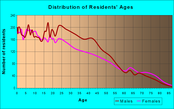
| Males: | 24,281 |
| Females: | 25,128 |
Males:
| This neighborhood: | 32.9 years |
| Whole city: | 34.4 years |
| This neighborhood: | 41.0 years |
| Whole city: | 34.7 years |
Average household size:
| Port Houston (Denver Harbor): | 2.8 people |
| Houston: | 2.4 people |
Percentage of family households:
| Port Houston (Denver Harbor): | 44.5% |
| Houston: | 43.0% |
| Here: | 27.5% |
| Houston: | 34.7% |
Percentage of married-couple families with children (among all households):
| Port Houston (Denver Harbor): | 20.9% |
| Houston: | 23.3% |
Percentage of single-mother households (among all households):
| Port Houston (Denver Harbor): | 13.2% |
| Houston: | 13.9% |
Percentage of never married males 15 years old and over:
Percentage of never married females 15 years old and over:
| Port Houston (Denver Harbor): | 23.3% |
| Houston: | 22.9% |
Percentage of never married females 15 years old and over:
| Port Houston (Denver Harbor): | 15.0% |
| city: | 21.2% |
Percentage of people that speak English not well or not at all:
| Port Houston (Denver Harbor): | 15.1% |
| Houston: | 15.9% |
Percentage of people born in this state:
Percentage of people born in another U.S. state:
Percentage of native residents but born outside the U.S.:
Percentage of foreign born residents:
| Here: | 74.9% |
| Houston: | 51.1% |
Percentage of people born in another U.S. state:
| Port Houston (Denver Harbor): | 3.3% |
| Houston: | 17.7% |
Percentage of native residents but born outside the U.S.:
| Here: | 4.9% |
| city: | 1.8% |
Percentage of foreign born residents:
| Here: | 16.9% |
| Houston: | 29.4% |
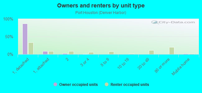
Owner-occupied
Renter-occupied

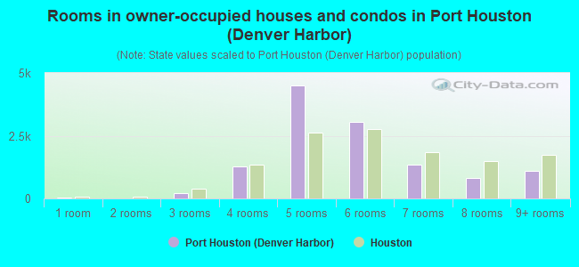
- Rooms in owner-occupied houses and condos in Port Houston <
> - 331 room
- 02 rooms
- 2223 rooms
- 1,2894 rooms
- 4,5165 rooms
- 3,0456 rooms
- 1,3547 rooms
- 8238 rooms
- 1,1059+ rooms
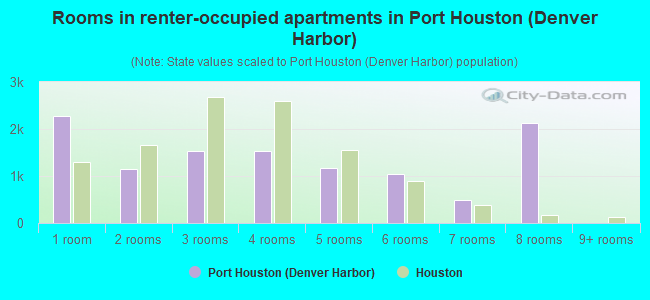
- Rooms in renter-occupied apartments in Port Houston <
> - 2,2771 room
- 1,1472 rooms
- 1,5393 rooms
- 1,5364 rooms
- 1,1795 rooms
- 1,0426 rooms
- 4967 rooms
- 2,1258 rooms
- 09+ rooms
Owner-occupied
Renter-occupied
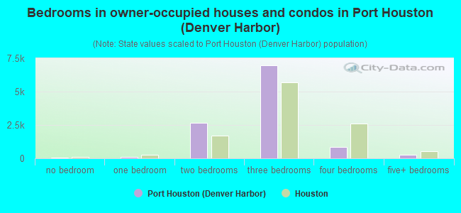
- Bedrooms in owner-occupied houses and condos in Port Houston <
> - 33no bedroom
- 831 bedroom
- 2,6612 bedrooms
- 6,9943 bedrooms
- 8744 bedrooms
- 2515+ bedrooms
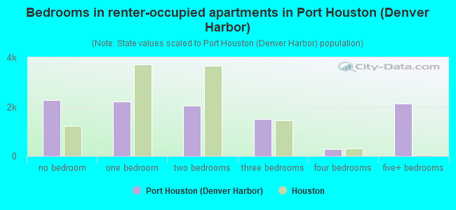
- Bedrooms in renter-occupied apartments in Port Houston <
> - 2,277no bedroom
- 2,2061 bedroom
- 2,0392 bedrooms
- 1,4953 bedrooms
- 2714 bedrooms
- 2,1255+ bedrooms
Average number of cars or other vehicles available in houses/condos:
Average number of cars or other vehicles available in apartments:
| This neighborhood: | 1.8 |
| Houston: | 2.0 |
Average number of cars or other vehicles available in apartments:
| Here: | 1.4 |
| city: | 1.3 |
Percentage of units with a mortgage:
| Port Houston (Denver Harbor): | 28.5% |
| Houston: | 50.8% |
Average estimated value of detached houses in 2022 (81.9% of all units):
| Port Houston (Denver Harbor): | $135,500 |
| Houston: | $368,067 |
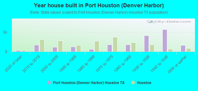
- Year house built in Port Houston <
> - 2962020 or later
- 1,6882010 to 2019
- 1,2142000 to 2009
- 1,2331990 to 1999
- 6571980 to 1989
- 1,8071970 to 1979
- 1,8221960 to 1969
- 4,1991950 to 1959
- 5,7051940 to 1949
- 1,6341939 or earlier
City-data.com crime index for city in 2020 (higher means more crime):
| City: | 560.9 |
| U.S. average: | 219.5 |
Travel time to work (commute)
![Travel time to work (commute)]()
- 950Less than 5 minutes
- 1,3245 to 9 minutes
- 2,84510 to 14 minutes
- 4,11215 to 19 minutes
- 4,64820 to 24 minutes
- 1,09725 to 29 minutes
- 4,45930 to 34 minutes
- 68435 to 39 minutes
- 1,94540 to 44 minutes
- 1,83345 to 59 minutes
- 56660 to 89 minutes
- 30990 or more minutes

Means of transportation to work
![Means of transportation to work]()
- 89.1%17,799Drove a car alone
- 6.7%1,346Carpooled
- 4.6%911Bus
- 0.1%27Light rail, streetcar or trolley
- 0.1%26Bicycle
- 2.6%521Walked
- 0.7%142Other means
- 0.9%185Worked at home

Time leaving home to go to work
![Time leaving home to go to work]()
- 1,58812:00 a.m. to 4:59 a.m.
- 1,4175:00 a.m. to 5:29 a.m.
- 1,3045:30 a.m. to 5:59 a.m.
- 5,0156:00 a.m. to 6:29 a.m.
- 9936:30 a.m. to 6:59 a.m.
- 4,9857:00 a.m. to 7:29 a.m.
- 8717:30 a.m. to 7:59 a.m.
- 1,4068:00 a.m. to 8:29 a.m.
- 1,2088:30 a.m. to 8:59 a.m.
- 1,1379:00 a.m. to 9:59 a.m.
- 23710:00 a.m. to 10:59 a.m.
- 6111:00 a.m. to 11:59 a.m.
- 2,26912:00 p.m. to 3:59 p.m.
- 1,9664:00 p.m. to 11:59 p.m.

Occupations of males:
- Percentage of males in management occupations (except farmers):
Here: 6.8% city: 10.6%
- Percentage of males in architecture and engineering occupations:
Here: 2.7% city: 4.0%
- Percentage of males in legal occupations:
Here: 1.3% city: 1.4%
- Percentage of males in education, training, and library occupations:
Here: 1.1% city: 3.1%
- Percentage of males in service occupations:
Here: 10.3% city: 12.9%
- Percentage of males in sales and office occupations:
Here: 14.3% city: 13.5%
- Percentage of males in farming, fishing, and forestry occupations:
Here: 2.3% city: 0.2%
- Percentage of males in construction, extraction, and maintenance occupations:
Here: 42.2% city: 15.7%
- Percentage of males in production occupations:
Here: 8.4% city: 6.0%
- Percentage of males in transportation occupations:
Here: 7.7% city: 6.1%
- Percentage of males in material moving occupations:
Here: 2.3% city: 5.4%
Occupations of females:
- Percentage of females in business and financial operations occupations:
Here: 1.9% city: 6.8%
- Percentage of females in computer and mathematical occupations:
Here: 2.4% city: 1.7%
- Percentage of females in community and social services occupations:
Here: 2.3% city: 1.8%
- Percentage of females in healthcare practitioners and technical occupations:
Here: 2.6% city: 8.1%
- Percentage of females in service occupations:
Here: 38.3% city: 23.8%
- Percentage of females in sales and office occupations:
Here: 35.4% city: 26.6%
- Percentage of females in production occupations:
Here: 13.2% city: 2.6%
- Percentage of females in transportation occupations:
Here: 1.1% city: 1.2%
- Percentage of females in material moving occupations:
Here: 2.4% city: 2.5%
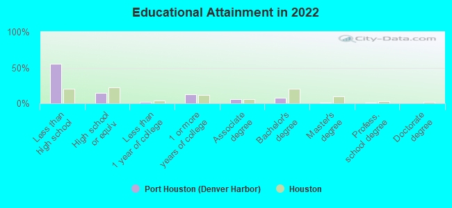
Education in this neighborhood (subdivision or community):
- Percentage of people 3 years and older in K-12 schools:
Port Houston (Denver Harbor): 24.6% Houston: 16.6%
- Percentage of people 3 years and older in undergraduate colleges:
Port Houston (Denver Harbor): 5.8% Houston: 4.6%
- Percentage of people 3 years and older in grad. or professional schools:
Port Houston (Denver Harbor): 0.5% Houston: 1.6%
- Percentage of students K-12 enrolled in private schools:
Port Houston (Denver Harbor): 7.1% Houston: 9.0%
Percentage of population below poverty level:
| Port Houston (Denver Harbor): | 26.5% |
| Houston: | 20.7% |
Median year owner moved in (as recorded in 2022):
Median year renter moved in (as recorded in 2022):
| Port Houston (Denver Harbor): | 1998 |
| Houston: | 2010 |
Median year renter moved in (as recorded in 2022):
| Port Houston (Denver Harbor): | 2015 |
| Houston: | 2020 |
Percentage of married-couple families with both working:
| Port Houston (Denver Harbor): | 58.2% |
| Houston: | 54.9% |
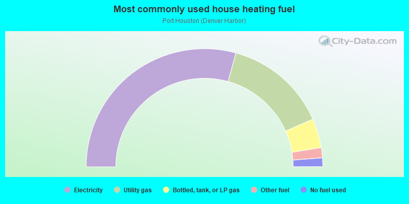
- 58.6%Electricity
- 28.2%Utility gas
- 8.0%Bottled, tank, or LP gas
- 2.8%Other fuel
- 2.4%No fuel used
Limited-access highways (interstate or state) in this neighborhood:
East Fwy (US Hwy 90, I- 10)
Length: 3.68 miles
Directions: E-W, SW-NE
Directions: E-W, SW-NE
I- 610 (E Loop Fwy)
Length: 1.67 miles
Direction: N-S
Direction: N-S
Highways in this neighborhood:
US Hwy 90 Alt (N Wayside Dr)
Length: 5.08 miles
Directions: N-S, SW-NE
Address range: 951 to 2599
Directions: N-S, SW-NE
Address range: 951 to 2599
N McCarty St (US Hwy 90 Alt)
Length: 0.21 miles
Direction: N-S
Address range: 409 to 599
Direction: N-S
Address range: 409 to 599
Roads and streets:
Clinton Dr
Length: 3.09 miles
Directions: E-W, SE-NW, SW-NE
Address range: 5801 to 8843
Directions: E-W, SE-NW, SW-NE
Address range: 5801 to 8843
Kress St
Length: 2.27 miles
Directions: N-S, SW-NE
Address range: 100 to 1898
Directions: N-S, SW-NE
Address range: 100 to 1898
Lathrop St
Length: 1.99 miles
Direction: N-S
Address range: 1 to 1599
Direction: N-S
Address range: 1 to 1599
Old Clinton Rd
Length: 1.98 miles
Directions: E-W, N-S, SE-NW, SW-NE
Address range: 5600 to 9099
Directions: E-W, N-S, SE-NW, SW-NE
Address range: 5600 to 9099
Hillsboro St
Length: 1.88 miles
Direction: E-W
Address range: 5900 to 8199
Direction: E-W
Address range: 5900 to 8199
Hershe St
Length: 1.86 miles
Direction: E-W
Address range: 5900 to 8199
Direction: E-W
Address range: 5900 to 8199
Boyles St
Length: 1.83 miles
Directions: N-S, SW-NE
Address range: 100 to 1599
Directions: N-S, SW-NE
Address range: 100 to 1599
Lyons Ave
Length: 1.78 miles
Directions: E-W, SE-NW
Address range: 5900 to 8199
Directions: E-W, SE-NW
Address range: 5900 to 8199
Market St
Length: 1.77 miles
Direction: E-W
Address range: 6000 to 7799
Direction: E-W
Address range: 6000 to 7799
Pearl St
Length: 1.68 miles
Direction: N-S
Address range: 400 to 2499
Direction: N-S
Address range: 400 to 2499
Wallisville Rd
Length: 1.63 miles
Direction: E-W
Address range: 5801 to 7699
Direction: E-W
Address range: 5801 to 7699
Hahlo St
Length: 1.61 miles
Directions: N-S, SW-NE
Address range: 100 to 1399
Directions: N-S, SW-NE
Address range: 100 to 1399
Harris St
Length: 1.59 miles
Directions: E-W, N-S, SE-NW, SW-NE
Address range: 100 to 1499
Directions: E-W, N-S, SE-NW, SW-NE
Address range: 100 to 1499
Port St
Length: 1.55 miles
Directions: E-W, N-S, SE-NW, SW-NE
Address range: 100 to 1449
Directions: E-W, N-S, SE-NW, SW-NE
Address range: 100 to 1449
Lower Level Rd
Length: 1.55 miles
Directions: E-W, N-S, SE-NW, SW-NE
Directions: E-W, N-S, SE-NW, SW-NE
S McCarty St
Length: 1.52 miles
Direction: N-S
Address range: 900 to 2417
Direction: N-S
Address range: 900 to 2417
Hoffman St
Length: 1.52 miles
Directions: N-S, SE-NW
Address range: 100 to 1299
Directions: N-S, SE-NW
Address range: 100 to 1299
Gazin St
Length: 1.49 miles
Direction: N-S
Address range: 500 to 1799
Direction: N-S
Address range: 500 to 1799
High Level Rd
Length: 1.39 miles
Directions: E-W, N-S, SE-NW, SW-NE
Directions: E-W, N-S, SE-NW, SW-NE
Woolworth St
Length: 1.35 miles
Directions: E-W, N-S
Address range: 100 to 1199
Directions: E-W, N-S
Address range: 100 to 1199
Zoe St
Length: 1.33 miles
Direction: N-S
Address range: 100 to 1199
Direction: N-S
Address range: 100 to 1199
Wayside Dr
Length: 1.32 miles
Directions: E-W, N-S, SW-NE
Address range: 140 to 973
Directions: E-W, N-S, SW-NE
Address range: 140 to 973
Dorsett St (Dorsett Ave)
Length: 1.23 miles
Direction: N-S
Address range: 700 to 2349
Direction: N-S
Address range: 700 to 2349
Laredo St
Length: 1.20 miles
Direction: E-W
Address range: 6300 to 8199
Direction: E-W
Address range: 6300 to 8199
Alderson St
Length: 1.18 miles
Direction: E-W
Address range: 5900 to 7599
Direction: E-W
Address range: 5900 to 7599
Texarkana St
Length: 1.15 miles
Direction: E-W
Address range: 6200 to 7599
Direction: E-W
Address range: 6200 to 7599
Longview St
Length: 1.15 miles
Direction: E-W
Address range: 6200 to 7599
Direction: E-W
Address range: 6200 to 7599
Gainesville St
Length: 1.15 miles
Directions: E-W, SW-NE
Address range: 6200 to 7599
Directions: E-W, SW-NE
Address range: 6200 to 7599
Force St
Length: 1.15 miles
Direction: E-W
Address range: 6200 to 7599
Direction: E-W
Address range: 6200 to 7599
Amarillo St
Length: 1.13 miles
Direction: E-W
Address range: 6900 to 8199
Direction: E-W
Address range: 6900 to 8199
Shotwell St
Length: 1.13 miles
Directions: E-W, N-S, SW-NE
Address range: 94 to 1299
Directions: E-W, N-S, SW-NE
Address range: 94 to 1299
Crown St
Length: 1.10 miles
Directions: N-S, SE-NW
Address range: 101 to 1049
Directions: N-S, SE-NW
Address range: 101 to 1049
Grand Blvd
Length: 1.09 miles
Directions: E-W, SE-NW, SW-NE
Address range: 7500 to 7799
Directions: E-W, SE-NW, SW-NE
Address range: 7500 to 7799
Corpus Christi St
Length: 1.08 miles
Direction: E-W
Address range: 6300 to 7599
Direction: E-W
Address range: 6300 to 7599
Victoria St
Length: 1.08 miles
Direction: E-W
Address range: 6300 to 7599
Direction: E-W
Address range: 6300 to 7599
Eagle Pass St
Length: 1.08 miles
Direction: E-W
Address range: 6301 to 7599
Direction: E-W
Address range: 6301 to 7599
Rouse St
Length: 1.08 miles
Direction: N-S
Address range: 100 to 1199
Direction: N-S
Address range: 100 to 1199
Waxahachie St
Length: 1.05 miles
Direction: E-W
Address range: 6900 to 8199
Direction: E-W
Address range: 6900 to 8199
Daugherty St
Length: 0.98 miles
Direction: N-S
Address range: 1300 to 2399
Direction: N-S
Address range: 1300 to 2399
Brownsville St
Length: 0.94 miles
Direction: E-W
Address range: 6500 to 7599
Direction: E-W
Address range: 6500 to 7599
Armour Dr
Length: 0.88 miles
Directions: E-W, SW-NE
Address range: 5600 to 6099
Directions: E-W, SW-NE
Address range: 5600 to 6099
Henke St
Length: 0.87 miles
Direction: N-S
Address range: 400 to 1199
Direction: N-S
Address range: 400 to 1199
Exchange St
Length: 0.85 miles
Directions: E-W, N-S, SE-NW
Address range: 300 to 3412
Directions: E-W, N-S, SE-NW
Address range: 300 to 3412
Majestic St
Length: 0.82 miles
Direction: N-S
Address range: 500 to 1199
Direction: N-S
Address range: 500 to 1199
Houston Harbor Blvd (Harbor St)
Length: 0.80 miles
Directions: N-S, SE-NW, SW-NE
Address range: 700 to 1199
Directions: N-S, SE-NW, SW-NE
Address range: 700 to 1199
Tilgham St
Length: 0.75 miles
Direction: E-W
Address range: 7200 to 8299
Direction: E-W
Address range: 7200 to 8299
Harbor Dr
Length: 0.74 miles
Directions: N-S, SE-NW
Address range: 100 to 1299
Directions: N-S, SE-NW
Address range: 100 to 1299
Gate 1 Rd
Length: 0.73 miles
Directions: N-S, SE-NW, SW-NE
Directions: N-S, SE-NW, SW-NE
Harvey Wilson Dr
Length: 0.72 miles
Direction: E-W
Address range: 5600 to 6999
Direction: E-W
Address range: 5600 to 6999
Larimer St
Length: 0.71 miles
Direction: E-W
Address range: 5950 to 6899
Direction: E-W
Address range: 5950 to 6899
San Pablo Dr
Length: 0.69 miles
Directions: E-W, N-S, SW-NE
Directions: E-W, N-S, SW-NE
Brownwood St
Length: 0.65 miles
Direction: E-W
Address range: 6900 to 7599
Direction: E-W
Address range: 6900 to 7599
Leslie St
Length: 0.64 miles
Direction: E-W
Address range: 6000 to 6899
Direction: E-W
Address range: 6000 to 6899
Abilene Ave (Abilene St)
Length: 0.64 miles
Direction: E-W
Address range: 6900 to 7599
Direction: E-W
Address range: 6900 to 7599
el Paso St
Length: 0.61 miles
Direction: E-W
Address range: 6900 to 7599
Direction: E-W
Address range: 6900 to 7599
San Angelo St
Length: 0.60 miles
Direction: E-W
Address range: 6900 to 7599
Direction: E-W
Address range: 6900 to 7599
Denison St
Length: 0.59 miles
Direction: E-W
Address range: 6900 to 7698
Direction: E-W
Address range: 6900 to 7698
Bonham St
Length: 0.58 miles
Direction: E-W
Address range: 6900 to 7699
Direction: E-W
Address range: 6900 to 7699
Cowart St
Length: 0.54 miles
Direction: E-W
Address range: 7200 to 8299
Direction: E-W
Address range: 7200 to 8299
Gonzales St
Length: 0.53 miles
Direction: E-W
Address range: 6900 to 7499
Direction: E-W
Address range: 6900 to 7499
Wiggins St
Length: 0.51 miles
Direction: E-W
Address range: 7200 to 8299
Direction: E-W
Address range: 7200 to 8299
Tuck St
Length: 0.51 miles
Direction: E-W
Address range: 6900 to 7499
Direction: E-W
Address range: 6900 to 7499
Anzac St
Length: 0.50 miles
Direction: E-W
Address range: 7100 to 7928
Direction: E-W
Address range: 7100 to 7928
Arapahoe St
Length: 0.50 miles
Direction: E-W
Address range: 6000 to 6899
Direction: E-W
Address range: 6000 to 6899
Boyce St
Length: 0.50 miles
Direction: E-W
Address range: 6900 to 7449
Direction: E-W
Address range: 6900 to 7449
Greenville St
Length: 0.48 miles
Direction: E-W
Address range: 6900 to 7499
Direction: E-W
Address range: 6900 to 7499
Labco St
Length: 0.48 miles
Directions: E-W, N-S
Address range: 1100 to 1299
Directions: E-W, N-S
Address range: 1100 to 1299
Tremper St
Length: 0.48 miles
Direction: E-W
Address range: 7100 to 7599
Direction: E-W
Address range: 7100 to 7599
Fillmore St
Length: 0.46 miles
Directions: E-W, N-S
Address range: 7900 to 8299
Directions: E-W, N-S
Address range: 7900 to 8299
Palestine St
Length: 0.45 miles
Direction: E-W
Address range: 6900 to 7399
Direction: E-W
Address range: 6900 to 7399
Corsicana St
Length: 0.44 miles
Direction: E-W
Address range: 6900 to 7399
Direction: E-W
Address range: 6900 to 7399
Terminal St
Length: 0.44 miles
Directions: N-S, SE-NW, SW-NE
Address range: 300 to 3499
Directions: N-S, SE-NW, SW-NE
Address range: 300 to 3499
Norvic St
Length: 0.43 miles
Direction: E-W
Address range: 7900 to 8299
Direction: E-W
Address range: 7900 to 8299
Pillot St
Length: 0.43 miles
Direction: E-W
Address range: 7900 to 8299
Direction: E-W
Address range: 7900 to 8299
Flaxman St
Length: 0.43 miles
Direction: E-W
Address range: 7900 to 8299
Direction: E-W
Address range: 7900 to 8299
Lane St
Length: 0.43 miles
Direction: E-W
Address range: 7900 to 8299
Direction: E-W
Address range: 7900 to 8299
Chadwick St
Length: 0.43 miles
Direction: E-W
Address range: 7900 to 8299
Direction: E-W
Address range: 7900 to 8299
Kerr St
Length: 0.43 miles
Direction: E-W
Address range: 7900 to 8299
Direction: E-W
Address range: 7900 to 8299
Buchanan St
Length: 0.43 miles
Direction: E-W
Address range: 7900 to 8300
Direction: E-W
Address range: 7900 to 8300
Richards St
Length: 0.43 miles
Direction: E-W
Address range: 7900 to 8299
Direction: E-W
Address range: 7900 to 8299
Mendez St
Length: 0.43 miles
Direction: E-W
Address range: 7900 to 8299
Direction: E-W
Address range: 7900 to 8299
Burman St
Length: 0.43 miles
Direction: E-W
Address range: 7900 to 8299
Direction: E-W
Address range: 7900 to 8299
Cargill St
Length: 0.42 miles
Direction: E-W
Address range: 7900 to 8299
Direction: E-W
Address range: 7900 to 8299
Port Houston
Length: 0.40 miles
Direction: N-S
Address range: 900 to 1299
Direction: N-S
Address range: 900 to 1299
Masterson St
Length: 0.39 miles
Direction: E-W
Address range: 7900 to 8299
Direction: E-W
Address range: 7900 to 8299
Garfield St
Length: 0.39 miles
Direction: E-W
Address range: 7900 to 8299
Direction: E-W
Address range: 7900 to 8299
Signet St
Length: 0.39 miles
Direction: E-W
Address range: 7900 to 8299
Direction: E-W
Address range: 7900 to 8299
Tuffly St
Length: 0.39 miles
Direction: E-W
Address range: 7900 to 8299
Direction: E-W
Address range: 7900 to 8299
McCarty St
Length: 0.37 miles
Direction: N-S
Address range: 631 to 899
Direction: N-S
Address range: 631 to 899
Munn St
Length: 0.34 miles
Direction: E-W
Address range: 7900 to 8199
Direction: E-W
Address range: 7900 to 8199
Market Street Rd
Length: 0.34 miles
Direction: E-W
Address range: 7800 to 8299
Direction: E-W
Address range: 7800 to 8299
Stedman St
Length: 0.29 miles
Direction: E-W
Address range: 7900 to 8299
Direction: E-W
Address range: 7900 to 8299
Colfax St
Length: 0.29 miles
Direction: E-W
Address range: 5900 to 6299
Direction: E-W
Address range: 5900 to 6299
Glenarm St
Length: 0.28 miles
Direction: E-W
Address range: 5900 to 6299
Direction: E-W
Address range: 5900 to 6299
69th St
Length: 0.28 miles
Directions: E-W, N-S, SE-NW, SW-NE
Address range: 2551 to 2599
Directions: E-W, N-S, SE-NW, SW-NE
Address range: 2551 to 2599
Plummer St
Length: 0.26 miles
Direction: E-W
Address range: 8000 to 8299
Direction: E-W
Address range: 8000 to 8299
Meters St
Length: 0.23 miles
Direction: N-S
Address range: 300 to 499
Direction: N-S
Address range: 300 to 499
Eagle Pass
Length: 0.22 miles
Direction: E-W
Address range: 7600 to 7799
Direction: E-W
Address range: 7600 to 7799
Downing St
Length: 0.21 miles
Directions: E-W, SW-NE
Address range: 5819 to 6199
Directions: E-W, SW-NE
Address range: 5819 to 6199
Turkey St (Plastics Ave)
Length: 0.21 miles
Direction: N-S
Direction: N-S
Heitman St
Length: 0.21 miles
Directions: E-W, N-S, SE-NW, SW-NE
Address range: 8700 to 8899
Directions: E-W, N-S, SE-NW, SW-NE
Address range: 8700 to 8899
Karnes St
Length: 0.19 miles
Direction: E-W
Address range: 7200 to 7399
Direction: E-W
Address range: 7200 to 7399
Gate 2 Rd
Length: 0.17 miles
Direction: N-S
Direction: N-S
Salina St
Length: 0.17 miles
Directions: E-W, SW-NE
Address range: 7600 to 7749
Directions: E-W, SW-NE
Address range: 7600 to 7749
Ranger Ave
Length: 0.15 miles
Direction: N-S
Address range: 400 to 599
Direction: N-S
Address range: 400 to 599
S Sgt Macario Garcia Dr
Length: 0.14 miles
Directions: E-W, N-S, SW-NE
Directions: E-W, N-S, SW-NE
Clinton-Wayside Dr
Length: 0.14 miles
Directions: N-S, SW-NE
Directions: N-S, SW-NE
Hewrick St
Length: 0.14 miles
Directions: E-W, N-S, SE-NW, SW-NE
Address range: 3300 to 3499
Directions: E-W, N-S, SE-NW, SW-NE
Address range: 3300 to 3499
Terminal
Length: 0.14 miles
Direction: N-S
Direction: N-S
Stonewall St
Length: 0.12 miles
Directions: E-W, SE-NW, SW-NE
Address range: 5900 to 6199
Directions: E-W, SE-NW, SW-NE
Address range: 5900 to 6199
Harris
Length: 0.11 miles
Direction: N-S
Direction: N-S
Bennett St
Length: 0.10 miles
Direction: E-W
Address range: 8100 to 8199
Direction: E-W
Address range: 8100 to 8199
Arlicious St
Length: 0.10 miles
Directions: E-W, N-S, SE-NW
Address range: 3300 to 3499
Directions: E-W, N-S, SE-NW
Address range: 3300 to 3499
Waxahachie
Length: 0.10 miles
Direction: E-W
Direction: E-W
Exchange
Length: 0.08 miles
Direction: N-S
Direction: N-S
Harbor
Length: 0.08 miles
Directions: N-S, SE-NW
Directions: N-S, SE-NW
Stuebner
Length: 0.07 miles
Direction: E-W
Address range: 8100 to 8199
Direction: E-W
Address range: 8100 to 8199
Crown
Length: 0.07 miles
Direction: N-S
Direction: N-S
Ranger St
Length: 0.05 miles
Direction: N-S
Address range: 600 to 699
Direction: N-S
Address range: 600 to 699
Clinton-Wayside
Length: 0.05 miles
Direction: N-S
Direction: N-S
Tuffly
Length: 0.05 miles
Direction: N-S
Direction: N-S
Lyons
Length: 0.04 miles
Direction: E-W
Direction: E-W
Gonzales
Length: 0.04 miles
Direction: E-W
Direction: E-W
Iris
Length: 0.04 miles
Direction: E-W
Direction: E-W
Tuck
Length: 0.04 miles
Direction: E-W
Direction: E-W
Lyons St
Length: 0.03 miles
Direction: E-W
Direction: E-W
Arapahoe
Length: 0.03 miles
Direction: E-W
Direction: E-W
Daugherty
Length: 0.03 miles
Direction: N-S
Direction: N-S
el Paso
Length: 0.03 miles
Direction: E-W
Direction: E-W
McCarty Dr
Length: 0.02 miles
Direction: N-S
Direction: N-S
Abilene
Length: 0.02 miles
Direction: E-W
Direction: E-W
Railroad features:
Southern Pacific RR
Length: 19.99 miles
Directions: E-W, N-S, SE-NW, SW-NE
Directions: E-W, N-S, SE-NW, SW-NE
Port Terminal RR
Length: 10.01 miles
Directions: E-W, N-S, SE-NW, SW-NE
Directions: E-W, N-S, SE-NW, SW-NE
Houston Belt and Terminal Rlwy
Length: 5.52 miles
Directions: N-S, SE-NW, SW-NE
Directions: N-S, SE-NW, SW-NE
Union Pacific RR
Length: 0.94 miles
Directions: E-W, N-S, SE-NW
Directions: E-W, N-S, SE-NW
Other features:
Hunting Byu
Length: 0.10 miles
Direction: SE-NW
Direction: SE-NW