Puritas-Longmead neighborhood in Cleveland, Ohio (OH), 44111, 44135 detailed profile
Settings
X


Business Search - 14 Million verified businesses
Area: 3.460 square miles
Population: 15,078
Population density:
| Puritas-Longmead: | 4,358 people per square mile |
| Cleveland: | 4,662 people per square mile |

- 7,70746.6%White
- 3,51921.3%Hispanic or Latino
- 2,71316.4%Black
- 1,0756.5%Asian
- 9745.9%Two or more races
- 3952.4%American Indian
- 1691.0%Some other race

Distribution of median household income
![Distribution of median household income]()
- 450Less than $10,000
- 1,474$10,000 to $19,999
- 811$20,000 to $29,999
- 823$30,000 to $39,999
- 732$40,000 to $49,999
- 485$50,000 to $59,999
- 746$60,000 to $74,999
- 851$75,000 to $99,999
- 474$100,000 to $124,999
- 331$125,000 to $149,999
- 359$150,000 to $199,999
- 322$200,000 or more

Distribution of owner-occupied house/condo value
![Distribution of owner-occupied house/condo value]()
- 3,609Less than $50,000
- 2,647$50,000 to $99,999
- 1,412$100,000 to $149,999
- 759$150,000 to $199,999
- 122$200,000 to $249,999
- 219$250,000 to $299,999
- 164$300,000 to $399,999
- 136$400,000 to $499,999
- 13$500,000 to $749,999
- 494$750,000 to $999,999
- 193$1,000,000 or more

Distribution of rent paid by renters
![Distribution of rent paid by renters]()
- 1,028Less than $100
- 2,604$100 to $199
- 963$200 to $299
- 655$300 to $399
- 525$400 to $499
- 582$500 to $599
- 578$600 to $699
- 961$700 to $799
- 483$800 to $899
- 948$900 to $999
- 298$1,000 to $1,249
- 954$1,250 to $1,499
- 418$1,500 to $1,999

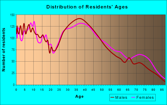
| Males: | 7,468 |
| Females: | 7,610 |
Males:
| This neighborhood: | |
| Whole city: |
| This neighborhood: | |
| Whole city: |
Percentage of family households:
| Puritas-Longmead: | 41.4% |
| Cleveland: | 32.3% |
| Here: | 26.0% |
| Cleveland: | 18.6% |
Percentage of married-couple families with children (among all households):
| Puritas-Longmead: | 21.3% |
| Cleveland: | 10.0% |
Percentage of single-mother households (among all households):
| Puritas-Longmead: | 22.4% |
| Cleveland: | 30.3% |
Percentage of never married males 15 years old and over:
Percentage of never married females 15 years old and over:
| Puritas-Longmead: | 27.2% |
| Cleveland: | 27.7% |
Percentage of never married females 15 years old and over:
| Puritas-Longmead: | 22.0% |
| city: | 26.3% |
Percentage of people that speak English not well or not at all:
| Puritas-Longmead: | 3.4% |
| Cleveland: | 2.7% |
Percentage of people born in this state:
Percentage of people born in another U.S. state:
Percentage of native residents but born outside the U.S.:
Percentage of foreign born residents:
| Here: | 70.0% |
| Cleveland: | 71.5% |
Percentage of people born in another U.S. state:
| Puritas-Longmead: | 15.1% |
| Cleveland: | 17.9% |
Percentage of native residents but born outside the U.S.:
| Here: | 6.7% |
| city: | 4.3% |
Percentage of foreign born residents:
| Here: | 8.2% |
| Cleveland: | 6.3% |

Owner-occupied
Renter-occupied


- Rooms in owner-occupied houses and condos in Puritas-Longmead
- 1191 room
- 302 rooms
- 813 rooms
- 5304 rooms
- 1,2005 rooms
- 1,0656 rooms
- 5627 rooms
- 4398 rooms
- 2839+ rooms

- Rooms in renter-occupied apartments in Puritas-Longmead
- 1391 room
- 4442 rooms
- 6173 rooms
- 9864 rooms
- 9235 rooms
- 4976 rooms
- 5297 rooms
- 2188 rooms
- 3379+ rooms
Owner-occupied
Renter-occupied

- Bedrooms in owner-occupied houses and condos in Puritas-Longmead
- 119no bedroom
- 9201 bedroom
- 1,3042 bedrooms
- 1,6873 bedrooms
- 5714 bedrooms
- 3915+ bedrooms

- Bedrooms in renter-occupied apartments in Puritas-Longmead
- 274no bedroom
- 1,0031 bedroom
- 1,0642 bedrooms
- 7353 bedrooms
- 4204 bedrooms
- 3375+ bedrooms
Average number of cars or other vehicles available in houses/condos:
Average number of cars or other vehicles available in apartments:
| This neighborhood: | |
| Cleveland: |
Average number of cars or other vehicles available in apartments:
| Here: | |
| city: |
Percentage of units with a mortgage:
| Puritas-Longmead: | 60.1% |
| Cleveland: | 50.7% |

- Year house built in Puritas-Longmead
- 4512020 or later
- 1,1592010 to 2019
- 2222000 to 2009
- 2151990 to 1999
- 6071980 to 1989
- 5571970 to 1979
- 5321960 to 1969
- 2,6711950 to 1959
- 1,6801940 to 1949
- 1,3761939 or earlier

City-data.com crime index for city in 2020 (higher means more crime):
| City: | 735.3 |
| U.S. average: | 219.5 |
Travel time to work (commute)
![Travel time to work (commute)]()
- 135Less than 5 minutes
- 4495 to 9 minutes
- 1,33310 to 14 minutes
- 1,13615 to 19 minutes
- 1,15220 to 24 minutes
- 70325 to 29 minutes
- 68430 to 34 minutes
- 25335 to 39 minutes
- 10740 to 44 minutes
- 27045 to 59 minutes
- 10560 to 89 minutes
- 7790 or more minutes

Means of transportation to work
![Means of transportation to work]()
- 69.5%4,725Drove a car alone
- 14.3%973Carpooled
- 7.6%518Bus
- 9.3%635Subway or elevated rail
- 0.9%60Long-distance train or commuter rail
- 0.6%44Light rail, streetcar or trolley
- 14.2%966Taxi
- 3.0%202Motorcycle
- 1.8%120Bicycle
- 8.1%548Walked
- 3.8%256Other means
- 10.8%737Worked at home

Time leaving home to go to work
![Time leaving home to go to work]()
- 41012:00 a.m. to 4:59 a.m.
- 2775:00 a.m. to 5:29 a.m.
- 5435:30 a.m. to 5:59 a.m.
- 5986:00 a.m. to 6:29 a.m.
- 6306:30 a.m. to 6:59 a.m.
- 5347:00 a.m. to 7:29 a.m.
- 4567:30 a.m. to 7:59 a.m.
- 6448:00 a.m. to 8:29 a.m.
- 1458:30 a.m. to 8:59 a.m.
- 3109:00 a.m. to 9:59 a.m.
- 24110:00 a.m. to 10:59 a.m.
- 11211:00 a.m. to 11:59 a.m.
- 65612:00 p.m. to 3:59 p.m.
- 6174:00 p.m. to 11:59 p.m.

Occupations of males:
- Percentage of males in management occupations (except farmers):
Here: 6.3% city: 7.3%
- Percentage of males in business and financial operations occupations:
Here: 2.9% city: 4.6%
- Percentage of males in computer and mathematical occupations:
Here: 2.3% city: 3.6%
- Percentage of males in architecture and engineering occupations:
Here: 2.7% city: 1.8%
- Percentage of males in education, training, and library occupations:
Here: 1.1% city: 2.1%
- Percentage of males in service occupations:
Here: 18.9% city: 20.2%
- Percentage of males in sales and office occupations:
Here: 14.7% city: 14.2%
- Percentage of males in construction, extraction, and maintenance occupations:
Here: 7.0% city: 6.7%
- Percentage of males in production occupations:
Here: 14.8% city: 10.8%
- Percentage of males in transportation occupations:
Here: 5.4% city: 5.8%
- Percentage of males in material moving occupations:
Here: 17.0% city: 9.1%
Occupations of females:
- Percentage of females in management occupations (except farmers):
Here: 3.7% city: 6.9%
- Percentage of females in business and financial operations occupations:
Here: 4.4% city: 5.8%
- Percentage of females in community and social services occupations:
Here: 3.6% city: 2.8%
- Percentage of females in education, training, and library occupations:
Here: 2.0% city: 5.8%
- Percentage of females in healthcare practitioners and technical occupations:
Here: 7.4% city: 9.3%
- Percentage of females in service occupations:
Here: 26.5% city: 26.3%
- Percentage of females in sales and office occupations:
Here: 36.1% city: 27.0%
- Percentage of females in production occupations:
Here: 6.9% city: 5.0%
- Percentage of females in transportation occupations:
Here: 1.7% city: 2.4%
- Percentage of females in material moving occupations:
Here: 6.0% city: 2.6%
Percentage of people 16-64 in Armed Forces:
| Puritas-Longmead: | 0.1% |
| Cleveland: | 0.3% |
Education in this neighborhood (subdivision or community):
- Percentage of people 3 years and older in K-12 schools:
Puritas-Longmead: 25.9% Cleveland: 15.5%
- Percentage of people 3 years and older in undergraduate colleges:
Puritas-Longmead: 9.1% Cleveland: 5.1%
- Percentage of people 3 years and older in grad. or professional schools:
Puritas-Longmead: 1.7% Cleveland: 1.7%
- Percentage of students K-12 enrolled in private schools:
Puritas-Longmead: 51.3% Cleveland: 22.4%
Percentage of population below poverty level:
| Puritas-Longmead: | 22.7% |
| Cleveland: | 31.8% |
Percentage of married-couple families with both working:
| Puritas-Longmead: | 132.5% |
| Cleveland: | 72.0% |

- 71.5%Utility gas
- 14.4%Electricity
- 6.1%Other fuel
- 3.2%Bottled, tank, or LP gas
- 2.5%Wood
- 1.4%No fuel used
- 0.7%Fuel oil, kerosene, etc.
Limited-access highways (interstate or state) in this neighborhood:
Outerbelt South Fwy (I- 480)
Length: 2.45 miles
Directions: E-W, SW-NE
Directions: E-W, SW-NE
I- 71
Length: 2.00 miles
Directions: E-W, SW-NE
Directions: E-W, SW-NE
Highways in this neighborhood:
Brookpark Rd (State Rte 17)
Length: 0.78 miles
Direction: E-W
Address range: 11502 to 12999
Direction: E-W
Address range: 11502 to 12999
Roads and streets:
W 130th St
Length: 2.05 miles
Direction: N-S
Address range: 3900 to 4999
Direction: N-S
Address range: 3900 to 4999
Industrial Pkwy
Length: 1.97 miles
Directions: E-W, N-S, SE-NW, SW-NE
Address range: 4400 to 16099
Directions: E-W, N-S, SE-NW, SW-NE
Address range: 4400 to 16099
Bellaire Rd
Length: 1.75 miles
Directions: E-W, SW-NE
Address range: 11765 to 13899
Directions: E-W, SW-NE
Address range: 11765 to 13899
Bennington Ave
Length: 1.23 miles
Direction: E-W
Address range: 11900 to 13998
Direction: E-W
Address range: 11900 to 13998
Carrington Ave
Length: 1.20 miles
Direction: E-W
Address range: 11800 to 13799
Direction: E-W
Address range: 11800 to 13799
Kirton Ave
Length: 1.16 miles
Direction: E-W
Address range: 11801 to 13799
Direction: E-W
Address range: 11801 to 13799
W 140th St
Length: 1.15 miles
Direction: N-S
Address range: 3900 to 4609
Direction: N-S
Address range: 3900 to 4609
Sprecher Ave
Length: 1.12 miles
Direction: E-W
Address range: 12100 to 13899
Direction: E-W
Address range: 12100 to 13899
Emery Ave
Length: 1.03 miles
Direction: E-W
Address range: 11900 to 13999
Direction: E-W
Address range: 11900 to 13999
Crossburn Ave
Length: 0.94 miles
Direction: E-W
Address range: 12300 to 13899
Direction: E-W
Address range: 12300 to 13899
Brookside Blvd
Length: 0.89 miles
Directions: E-W, N-S, SE-NW, SW-NE
Address range: 3800 to 4299
Directions: E-W, N-S, SE-NW, SW-NE
Address range: 3800 to 4299
Astor Ave
Length: 0.89 miles
Direction: E-W
Address range: 12500 to 13799
Direction: E-W
Address range: 12500 to 13799
Enterprise Ave
Length: 0.77 miles
Directions: E-W, SE-NW
Address range: 13000 to 14299
Directions: E-W, SE-NW
Address range: 13000 to 14299
Victory Blvd
Length: 0.76 miles
Directions: E-W, N-S, SW-NE
Address range: 3900 to 4299
Directions: E-W, N-S, SW-NE
Address range: 3900 to 4299
W 137th St
Length: 0.76 miles
Directions: N-S, SE-NW
Address range: 3934 to 4751
Directions: N-S, SE-NW
Address range: 3934 to 4751
Brooklawn Ave
Length: 0.75 miles
Directions: E-W, SW-NE
Address range: 11700 to 12999
Directions: E-W, SW-NE
Address range: 11700 to 12999
W 150th St
Length: 0.75 miles
Directions: N-S, SW-NE
Address range: 4501 to 4949
Directions: N-S, SW-NE
Address range: 4501 to 4949
Harold Ave
Length: 0.74 miles
Direction: E-W
Address range: 13000 to 13999
Direction: E-W
Address range: 13000 to 13999
Erwin Ave
Length: 0.73 miles
Direction: E-W
Address range: 11700 to 12999
Direction: E-W
Address range: 11700 to 12999
Milligan Ave
Length: 0.73 miles
Direction: E-W
Address range: 11700 to 12999
Direction: E-W
Address range: 11700 to 12999
Puritas Ave
Length: 0.72 miles
Directions: E-W, SW-NE
Address range: 12950 to 13999
Directions: E-W, SW-NE
Address range: 12950 to 13999
Longmead Ave
Length: 0.72 miles
Direction: E-W
Address range: 11700 to 12999
Direction: E-W
Address range: 11700 to 12999
W 134th St
Length: 0.72 miles
Directions: N-S, SE-NW
Address range: 4130 to 4797
Directions: N-S, SE-NW
Address range: 4130 to 4797
St John Ave
Length: 0.71 miles
Directions: E-W, SW-NE
Address range: 11800 to 12899
Directions: E-W, SW-NE
Address range: 11800 to 12899
Lena Ave
Length: 0.69 miles
Direction: E-W
Address range: 11700 to 12999
Direction: E-W
Address range: 11700 to 12999
Summerland Ave
Length: 0.67 miles
Directions: E-W, SW-NE
Address range: 11800 to 12899
Directions: E-W, SW-NE
Address range: 11800 to 12899
Leeila Ave
Length: 0.67 miles
Directions: E-W, SE-NW
Address range: 11800 to 12999
Directions: E-W, SE-NW
Address range: 11800 to 12999
Hirst Ave
Length: 0.65 miles
Directions: E-W, N-S, SW-NE
Address range: 11800 to 12999
Directions: E-W, N-S, SW-NE
Address range: 11800 to 12999
Tyler Ave
Length: 0.64 miles
Direction: E-W
Address range: 13000 to 13999
Direction: E-W
Address range: 13000 to 13999
Wanda Ave
Length: 0.64 miles
Directions: E-W, SE-NW, SW-NE
Address range: 12001 to 12999
Directions: E-W, SE-NW, SW-NE
Address range: 12001 to 12999
Thornhope Rd
Length: 0.63 miles
Directions: E-W, N-S, SW-NE
Address range: 13200 to 13999
Directions: E-W, N-S, SW-NE
Address range: 13200 to 13999
Highlandview Ave
Length: 0.59 miles
Direction: E-W
Address range: 13000 to 13999
Direction: E-W
Address range: 13000 to 13999
Brookfield Ave
Length: 0.57 miles
Direction: E-W
Address range: 12000 to 12998
Direction: E-W
Address range: 12000 to 12998
W 139th St
Length: 0.55 miles
Directions: N-S, SW-NE
Address range: 4300 to 4899
Directions: N-S, SW-NE
Address range: 4300 to 4899
Courtland Ave
Length: 0.53 miles
Direction: E-W
Address range: 13000 to 13999
Direction: E-W
Address range: 13000 to 13999
Terminal Ave
Length: 0.53 miles
Direction: E-W
Address range: 13000 to 13699
Direction: E-W
Address range: 13000 to 13699
Sherry Ave
Length: 0.53 miles
Directions: E-W, SE-NW
Address range: 13300 to 13999
Directions: E-W, SE-NW
Address range: 13300 to 13999
St James Ave
Length: 0.51 miles
Direction: E-W
Address range: 13000 to 13699
Direction: E-W
Address range: 13000 to 13699
Liberty Ave
Length: 0.51 miles
Direction: E-W
Address range: 13000 to 13999
Direction: E-W
Address range: 13000 to 13999
Guardian Blvd
Length: 0.50 miles
Direction: E-W
Address range: 12200 to 12999
Direction: E-W
Address range: 12200 to 12999
W Parkway Rd
Length: 0.49 miles
Directions: E-W, SE-NW
Address range: 13700 to 13999
Directions: E-W, SE-NW
Address range: 13700 to 13999
Clifford Ave
Length: 0.45 miles
Direction: E-W
Address range: 13216 to 13999
Direction: E-W
Address range: 13216 to 13999
Matherson Ave
Length: 0.43 miles
Direction: E-W
Address range: 12300 to 12999
Direction: E-W
Address range: 12300 to 12999
Wainstead Ave
Length: 0.43 miles
Direction: E-W
Address range: 13400 to 13999
Direction: E-W
Address range: 13400 to 13999
West Ave
Length: 0.42 miles
Direction: E-W
Address range: 13000 to 13599
Direction: E-W
Address range: 13000 to 13599
Wainfleet Ave
Length: 0.40 miles
Direction: E-W
Address range: 13000 to 13599
Direction: E-W
Address range: 13000 to 13599
Mc Gowan Ave
Length: 0.39 miles
Direction: E-W
Address range: 12050 to 12999
Direction: E-W
Address range: 12050 to 12999
Gilmore Ave
Length: 0.39 miles
Direction: E-W
Address range: 13000 to 13599
Direction: E-W
Address range: 13000 to 13599
W 160th St
Length: 0.39 miles
Directions: N-S, SW-NE
Address range: 4541 to 4809
Directions: N-S, SW-NE
Address range: 4541 to 4809
W 135th St
Length: 0.39 miles
Direction: N-S
Address range: 4457 to 4999
Direction: N-S
Address range: 4457 to 4999
Manufacturing Ave (Manufacturing Rd)
Length: 0.38 miles
Directions: N-S, SE-NW
Address range: 4500 to 4799
Directions: N-S, SE-NW
Address range: 4500 to 4799
Justin Ave
Length: 0.37 miles
Directions: E-W, SW-NE
Address range: 14600 to 14999
Directions: E-W, SW-NE
Address range: 14600 to 14999
W 125th St
Length: 0.36 miles
Direction: N-S
Address range: 4048 to 4799
Direction: N-S
Address range: 4048 to 4799
Coe Ave
Length: 0.36 miles
Direction: E-W
Address range: 14500 to 14999
Direction: E-W
Address range: 14500 to 14999
W 156th St
Length: 0.35 miles
Directions: N-S, SW-NE
Address range: 4500 to 4799
Directions: N-S, SW-NE
Address range: 4500 to 4799
W 127th St
Length: 0.35 miles
Direction: N-S
Address range: 4100 to 4735
Direction: N-S
Address range: 4100 to 4735
Belleshire Ave
Length: 0.35 miles
Direction: E-W
Address range: 13500 to 13999
Direction: E-W
Address range: 13500 to 13999
Leroy Ave
Length: 0.34 miles
Direction: E-W
Address range: 13500 to 13999
Direction: E-W
Address range: 13500 to 13999
Sobieski Ave
Length: 0.32 miles
Direction: E-W
Address range: 12100 to 12699
Direction: E-W
Address range: 12100 to 12699
Grimsby Ave
Length: 0.32 miles
Direction: E-W
Address range: 12200 to 12899
Direction: E-W
Address range: 12200 to 12899
Firsby Ave
Length: 0.31 miles
Direction: E-W
Address range: 12300 to 12999
Direction: E-W
Address range: 12300 to 12999
Giles Rd
Length: 0.31 miles
Directions: N-S, SW-NE
Address range: 4600 to 4699
Directions: N-S, SW-NE
Address range: 4600 to 4699
W 121st St
Length: 0.29 miles
Direction: N-S
Address range: 4200 to 4685
Direction: N-S
Address range: 4200 to 4685
Wilton Ave
Length: 0.29 miles
Direction: E-W
Address range: 13000 to 13499
Direction: E-W
Address range: 13000 to 13499
Elsetta Ave
Length: 0.28 miles
Direction: E-W
Address range: 13600 to 13999
Direction: E-W
Address range: 13600 to 13999
W 131st St
Length: 0.28 miles
Direction: N-S
Address range: 4313 to 4499
Direction: N-S
Address range: 4313 to 4499
Violet Ave
Length: 0.28 miles
Direction: E-W
Address range: 15000 to 15599
Direction: E-W
Address range: 15000 to 15599
London Ave
Length: 0.28 miles
Direction: E-W
Address range: 15300 to 15599
Direction: E-W
Address range: 15300 to 15599
Kadel Ave
Length: 0.28 miles
Direction: E-W
Address range: 12600 to 12999
Direction: E-W
Address range: 12600 to 12999
Willman Ave
Length: 0.28 miles
Direction: E-W
Address range: 15000 to 15512
Direction: E-W
Address range: 15000 to 15512
W 138th St
Length: 0.26 miles
Direction: N-S
Address range: 4300 to 4599
Direction: N-S
Address range: 4300 to 4599
W 149th St
Length: 0.26 miles
Direction: N-S
Address range: 4578 to 4799
Direction: N-S
Address range: 4578 to 4799
W 148th St
Length: 0.26 miles
Direction: N-S
Address range: 4578 to 4799
Direction: N-S
Address range: 4578 to 4799
W 146th St
Length: 0.26 miles
Direction: N-S
Address range: 4578 to 4799
Direction: N-S
Address range: 4578 to 4799
Briar Rd
Length: 0.26 miles
Directions: E-W, N-S, SE-NW, SW-NE
Address range: 4700 to 4999
Directions: E-W, N-S, SE-NW, SW-NE
Address range: 4700 to 4999
W 147th St
Length: 0.26 miles
Direction: N-S
Address range: 4579 to 4726
Direction: N-S
Address range: 4579 to 4726
W 123rd St
Length: 0.24 miles
Direction: N-S
Address range: 4200 to 4615
Direction: N-S
Address range: 4200 to 4615
W 143rd St
Length: 0.22 miles
Directions: E-W, N-S
Address range: 4442 to 4499
Directions: E-W, N-S
Address range: 4442 to 4499
Ventnor Ave
Length: 0.21 miles
Direction: E-W
Address range: 15600 to 15849
Direction: E-W
Address range: 15600 to 15849
W 118th St
Length: 0.20 miles
Directions: N-S, SE-NW
Address range: 3850 to 4499
Directions: N-S, SE-NW
Address range: 3850 to 4499
Louis Ave
Length: 0.20 miles
Direction: E-W
Address range: 15200 to 15599
Direction: E-W
Address range: 15200 to 15599
Ellwood Ave
Length: 0.19 miles
Directions: E-W, SE-NW
Address range: 13500 to 13699
Directions: E-W, SE-NW
Address range: 13500 to 13699
Marlene Ave
Length: 0.18 miles
Direction: E-W
Address range: 15200 to 15599
Direction: E-W
Address range: 15200 to 15599
W 158th St
Length: 0.18 miles
Direction: N-S
Address range: 4600 to 4799
Direction: N-S
Address range: 4600 to 4799
W 157th St
Length: 0.15 miles
Direction: N-S
Address range: 4648 to 4799
Direction: N-S
Address range: 4648 to 4799
W 132nd St
Length: 0.13 miles
Direction: N-S
Address range: 4300 to 4399
Direction: N-S
Address range: 4300 to 4399
W 154th St
Length: 0.13 miles
Direction: N-S
Address range: 4538 to 4599
Direction: N-S
Address range: 4538 to 4599
W 136th St
Length: 0.12 miles
Direction: N-S
Address range: 4457 to 4599
Direction: N-S
Address range: 4457 to 4599
W 124th St
Length: 0.12 miles
Direction: N-S
Address range: 4616 to 4685
Direction: N-S
Address range: 4616 to 4685
Industrial Ln
Length: 0.12 miles
Directions: SE-NW, SW-NE
Address range: 14500 to 15999
Directions: SE-NW, SW-NE
Address range: 14500 to 15999
W 133rd St
Length: 0.11 miles
Direction: N-S
Address range: 4390 to 4499
Direction: N-S
Address range: 4390 to 4499
W 152nd St
Length: 0.11 miles
Directions: E-W, N-S
Address range: 4650 to 4749
Directions: E-W, N-S
Address range: 4650 to 4749
W 126th St
Length: 0.10 miles
Direction: N-S
Address range: 4746 to 4839
Direction: N-S
Address range: 4746 to 4839
W 129th St
Length: 0.09 miles
Direction: N-S
Address range: 3901 to 3999
Direction: N-S
Address range: 3901 to 3999
W 120th St
Length: 0.09 miles
Direction: N-S
Address range: 3900 to 3999
Direction: N-S
Address range: 3900 to 3999
Alexco Rd
Length: 0.08 miles
Directions: N-S, SW-NE
Address range: 4080 to 4109
Directions: N-S, SW-NE
Address range: 4080 to 4109
W 128th St
Length: 0.07 miles
Direction: N-S
Address range: 4450 to 4499
Direction: N-S
Address range: 4450 to 4499
Margate (Margate Ave)
Length: 0.06 miles
Direction: E-W
Address range: 15600 to 15622
Direction: E-W
Address range: 15600 to 15622
Hirst Ct
Length: 0.05 miles
Direction: N-S
Direction: N-S
Railroad features:
Csx RR (Conrail RR)
Length: 9.63 miles
Directions: E-W, N-S, SW-NE
Directions: E-W, N-S, SW-NE
Baltimore and Ohio RR
Length: 1.50 miles
Directions: E-W, N-S, SW-NE
Directions: E-W, N-S, SW-NE
Conrail RR
Length: 0.67 miles
Direction: SW-NE
Direction: SW-NE