Route 102 (Route 102-Grand River Avenue) neighborhood in Farmington, Michigan (MI), 48331, 48335 detailed profile
Settings
X


Business Search - 14 Million verified businesses
Area: 4.322 square miles
Population: 3,672
Population density:
| Route 102 (Route 102-Grand River Avenue): | 850 people per square mile |
| Farmington: | 4,303 people per square mile |

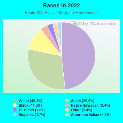
- 2,31948.3%White
- 1,43529.9%Asian
- 54311.3%Black
- 1613.4%Native Hawaiian and Other
Pacific Islander - 1362.8%Two or more races
- 1172.4%Some other race
- 841.7%Hispanic or Latino
- 80.2%American Indian
Median household income in 2022:
| Route 102 (Route 102-Grand River Avenue): | $125,107 |
| Farmington: | $92,128 |
Distribution of median household income
![Distribution of median household income]()
- 105Less than $10,000
- 147$10,000 to $19,999
- 171$20,000 to $29,999
- 70$30,000 to $39,999
- 73$40,000 to $49,999
- 104$50,000 to $59,999
- 98$60,000 to $74,999
- 235$75,000 to $99,999
- 342$100,000 to $124,999
- 139$125,000 to $149,999
- 305$150,000 to $199,999
- 358$200,000 or more

Distribution of owner-occupied house/condo value
![Distribution of owner-occupied house/condo value]()
- 289Less than $50,000
- 192$50,000 to $99,999
- 383$100,000 to $149,999
- 250$150,000 to $199,999
- 174$200,000 to $249,999
- 85$250,000 to $299,999
- 435$300,000 to $399,999
- 229$400,000 to $499,999
- 281$500,000 to $749,999
- 33$750,000 to $999,999
- 46$1,000,000 or more

Distribution of rent paid by renters
![Distribution of rent paid by renters]()
- 36Less than $100
- 21$100 to $199
- 121$200 to $299
- 88$400 to $499
- 26$500 to $599
- 20$600 to $699
- 49$700 to $799
- 162$900 to $999
- 305$1,000 to $1,249
- 182$1,250 to $1,499
- 118$1,500 to $1,999
- 462$2,000 or more

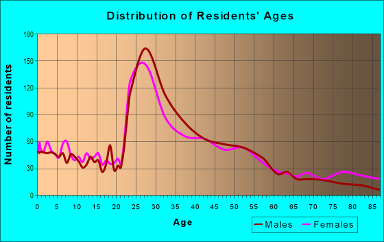
| Males: | 1,867 |
| Females: | 1,804 |
Males:
| This neighborhood: | 46.1 years |
| Whole city: | 35.3 years |
| This neighborhood: | 49.5 years |
| Whole city: | 42.4 years |
Average household size:
| Route 102 (Route 102-Grand River Avenue): | 2.4 people |
| Farmington: | 2.2 people |
Percentage of family households:
| Route 102 (Route 102-Grand River Avenue): | 47.4% |
| Farmington: | 41.0% |
| Here: | 64.0% |
| Farmington: | 45.5% |
Percentage of married-couple families with children (among all households):
| Route 102 (Route 102-Grand River Avenue): | 36.5% |
| Farmington: | 40.7% |
Percentage of single-mother households (among all households):
| Route 102 (Route 102-Grand River Avenue): | 5.5% |
| Farmington: | 4.2% |
Percentage of never married males 15 years old and over:
Percentage of never married females 15 years old and over:
| Route 102 (Route 102-Grand River Avenue): | 10.4% |
| Farmington: | 16.1% |
Percentage of never married females 15 years old and over:
| Route 102 (Route 102-Grand River Avenue): | 11.6% |
| city: | 15.2% |
Percentage of people that speak English not well or not at all:
| Route 102 (Route 102-Grand River Avenue): | 0.0% |
| Farmington: | 0.7% |
Percentage of people born in this state:
Percentage of people born in another U.S. state:
Percentage of native residents but born outside the U.S.:
Percentage of foreign born residents:
| Here: | 55.0% |
| Farmington: | 63.1% |
Percentage of people born in another U.S. state:
| Route 102 (Route 102-Grand River Avenue): | 15.4% |
| Farmington: | 16.3% |
Percentage of native residents but born outside the U.S.:
| Here: | 1.2% |
| city: | 0.8% |
Percentage of foreign born residents:
| Here: | 29.1% |
| Farmington: | 19.8% |
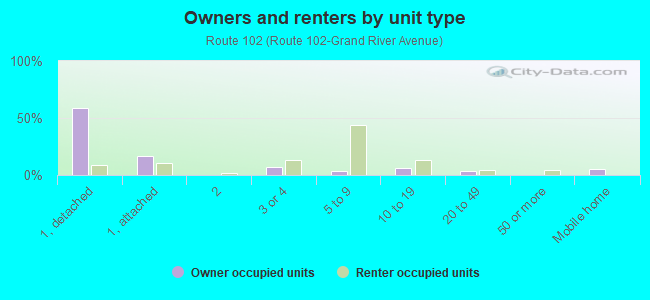
Owner-occupied
Renter-occupied

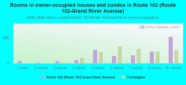
- Rooms in owner-occupied houses and condos in Route 102 <
> - 481 room
- 182 rooms
- 423 rooms
- 674 rooms
- 2655 rooms
- 1516 rooms
- 1607 rooms
- 2338 rooms
- 5249+ rooms
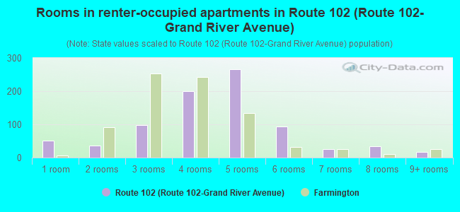
- Rooms in renter-occupied apartments in Route 102 <
> - 521 room
- 362 rooms
- 973 rooms
- 2004 rooms
- 2675 rooms
- 936 rooms
- 257 rooms
- 348 rooms
- 179+ rooms
Owner-occupied
Renter-occupied
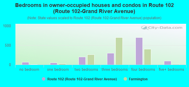
- Bedrooms in owner-occupied houses and condos in Route 102 <
> - 67no bedroom
- 511 bedroom
- 2002 bedrooms
- 2993 bedrooms
- 7004 bedrooms
- 955+ bedrooms
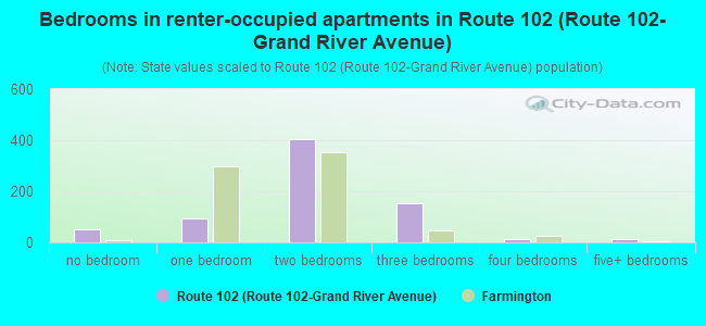
- Bedrooms in renter-occupied apartments in Route 102 <
> - 52no bedroom
- 951 bedroom
- 4052 bedrooms
- 1523 bedrooms
- 124 bedrooms
- 145+ bedrooms
Average number of cars or other vehicles available in houses/condos:
Average number of cars or other vehicles available in apartments:
| This neighborhood: | 2.0 |
| Farmington: | 1.9 |
Average number of cars or other vehicles available in apartments:
| Here: | |
| city: |
Percentage of units with a mortgage:
| Route 102 (Route 102-Grand River Avenue): | 54.0% |
| Farmington: | 63.7% |
Average estimated value of detached houses in 2022 (72.6% of all units):
| Route 102 (Route 102-Grand River Avenue): | $431,958 |
| Farmington: | $284,023 |
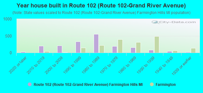
- Year house built in Route 102 <
> - 252020 or later
- 2042010 to 2019
- 2152000 to 2009
- 3261990 to 1999
- 5531980 to 1989
- 1961970 to 1979
- 1591960 to 1969
- 781950 to 1959
- 491940 to 1949
- 211939 or earlier
City-data.com crime index for city in 2020 (higher means more crime):
| City: | 33.2 |
| U.S. average: | 219.5 |
Travel time to work (commute)
![Travel time to work (commute)]()
- 49Less than 5 minutes
- 2155 to 9 minutes
- 66210 to 14 minutes
- 41715 to 19 minutes
- 44320 to 24 minutes
- 27025 to 29 minutes
- 65730 to 34 minutes
- 14535 to 39 minutes
- 13540 to 44 minutes
- 10245 to 59 minutes
- 20560 to 89 minutes
- 4190 or more minutes

Means of transportation to work
![Means of transportation to work]()
- 78.0%1,378Drove a car alone
- 16.4%289Carpooled
- 3.1%54Bus
- 1.7%30Bicycle
- 0.7%13Walked
- 0.4%7Other means
- 16.6%294Worked at home

Time leaving home to go to work
![Time leaving home to go to work]()
- 13812:00 a.m. to 4:59 a.m.
- 1045:00 a.m. to 5:29 a.m.
- 1545:30 a.m. to 5:59 a.m.
- 1996:00 a.m. to 6:29 a.m.
- 2176:30 a.m. to 6:59 a.m.
- 3947:00 a.m. to 7:29 a.m.
- 5327:30 a.m. to 7:59 a.m.
- 5308:00 a.m. to 8:29 a.m.
- 3208:30 a.m. to 8:59 a.m.
- 4769:00 a.m. to 9:59 a.m.
- 11410:00 a.m. to 10:59 a.m.
- 10911:00 a.m. to 11:59 a.m.
- 17112:00 p.m. to 3:59 p.m.
- 1424:00 p.m. to 11:59 p.m.

Occupations of males:
- Percentage of males in management occupations (except farmers):
Here: 25.2% city: 10.6%
- Percentage of males in business and financial operations occupations:
Here: 5.3% city: 8.7%
- Percentage of males in computer and mathematical occupations:
Here: 10.3% city: 21.4%
- Percentage of males in architecture and engineering occupations:
Here: 10.7% city: 13.8%
- Percentage of males in legal occupations:
Here: 1.3% city: 0.3%
- Percentage of males in education, training, and library occupations:
Here: 2.0% city: 1.9%
- Percentage of males in healthcare practitioners and technical occupations:
Here: 8.8% city: 2.6%
- Percentage of males in service occupations:
Here: 7.0% city: 5.6%
- Percentage of males in sales and office occupations:
Here: 18.1% city: 14.6%
- Percentage of males in construction, extraction, and maintenance occupations:
Here: 2.3% city: 4.2%
- Percentage of males in production occupations:
Here: 3.0% city: 4.4%
- Percentage of males in material moving occupations:
Here: 3.5% city: 0.9%
Occupations of females:
- Percentage of females in management occupations (except farmers):
Here: 9.5% city: 9.9%
- Percentage of females in business and financial operations occupations:
Here: 7.2% city: 8.6%
- Percentage of females in computer and mathematical occupations:
Here: 3.5% city: 4.4%
- Percentage of females in architecture and engineering occupations:
Here: 2.7% city: 3.2%
- Percentage of females in education, training, and library occupations:
Here: 7.3% city: 7.1%
- Percentage of females in arts, design, entertainment, sports, and media occupations:
Here: 5.7% city: 2.1%
- Percentage of females in healthcare practitioners and technical occupations:
Here: 35.4% city: 11.4%
- Percentage of females in service occupations:
Here: 8.1% city: 16.3%
- Percentage of females in sales and office occupations:
Here: 13.4% city: 24.6%
- Percentage of females in production occupations:
Here: 1.1% city: 5.7%
- Percentage of females in transportation occupations:
Here: 4.2% city: 1.6%
- Percentage of females in material moving occupations:
Here: 4.7% city: 1.5%
Education in this neighborhood (subdivision or community):
- Percentage of people 3 years and older in K-12 schools:
Route 102 (Route 102-Grand River Avenue): 26.4% Farmington: 12.2%
- Percentage of people 3 years and older in undergraduate colleges:
Route 102 (Route 102-Grand River Avenue): 10.0% Farmington: 4.3%
- Percentage of people 3 years and older in grad. or professional schools:
Route 102 (Route 102-Grand River Avenue): 1.5% Farmington: 1.0%
- Percentage of students K-12 enrolled in private schools:
Route 102 (Route 102-Grand River Avenue): 67.4% Farmington: 17.8%
Percentage of population below poverty level:
| Route 102 (Route 102-Grand River Avenue): | 4.6% |
| Farmington: | 4.9% |
Median year owner moved in (as recorded in 2022):
| Route 102 (Route 102-Grand River Avenue): | 2007 |
| Farmington: | 2010 |
Percentage of married-couple families with both working:
| Route 102 (Route 102-Grand River Avenue): | 86.8% |
| Farmington: | 61.1% |
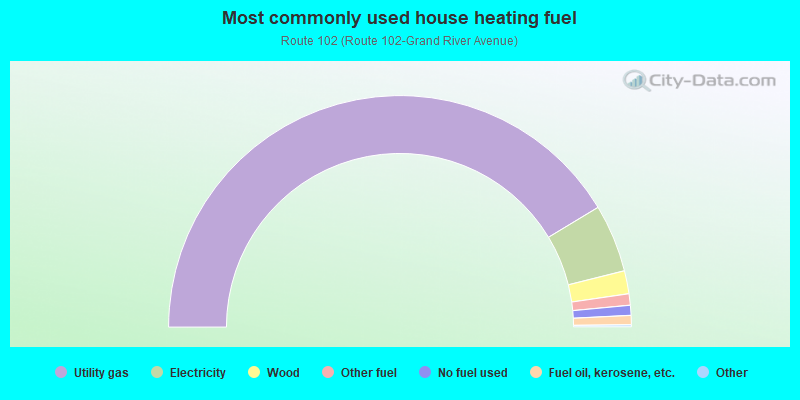
- 82.8%Utility gas
- 9.5%Electricity
- 3.2%Wood
- 1.6%Other fuel
- 1.4%No fuel used
- 1.3%Fuel oil, kerosene, etc.
Limited-access highways (interstate or state) in this neighborhood:
I- 696
Length: 5.51 miles
Directions: E-W, SW-NE
Directions: E-W, SW-NE
I- 275 (I- 96)
Length: 2.47 miles
Directions: E-W, N-S, SE-NW, SW-NE
Directions: E-W, N-S, SE-NW, SW-NE
Highways in this neighborhood:
State Hwy 102 (State Hwy 5)
Length: 3.15 miles
Directions: E-W, SE-NW
Directions: E-W, SE-NW
Roads and streets:
W 12 Mile Rd
Length: 2.66 miles
Direction: E-W
Address range: 35400 to 39399
Direction: E-W
Address range: 35400 to 39399
Grand River Ave
Length: 2.28 miles
Directions: E-W, SE-NW
Address range: 36002 to 39904
Directions: E-W, SE-NW
Address range: 36002 to 39904
Drake Rd
Length: 2.27 miles
Directions: E-W, N-S, SE-NW, SW-NE
Address range: 24200 to 27591
Directions: E-W, N-S, SE-NW, SW-NE
Address range: 24200 to 27591
Halsted Rd
Length: 2.01 miles
Direction: N-S
Address range: 24200 to 35399
Direction: N-S
Address range: 24200 to 35399
Haggerty Rd
Length: 2.00 miles
Direction: N-S
Address range: 24200 to 27799
Direction: N-S
Address range: 24200 to 27799
Independence Dr
Length: 1.53 miles
Directions: E-W, N-S, SE-NW, SW-NE
Address range: 24200 to 24799
Directions: E-W, N-S, SE-NW, SW-NE
Address range: 24200 to 24799
Hill Tech Dr
Length: 1.42 miles
Directions: E-W, SW-NE
Address range: 37400 to 39399
Directions: E-W, SW-NE
Address range: 37400 to 39399
Old Homestead Dr
Length: 1.33 miles
Directions: E-W, N-S, SE-NW, SW-NE
Address range: 26000 to 36399
Directions: E-W, N-S, SE-NW, SW-NE
Address range: 26000 to 36399
11 Mile Rd
Length: 1.31 miles
Direction: E-W
Address range: 35700 to 37400
Direction: E-W
Address range: 35700 to 37400
Howard Rd
Length: 1.25 miles
Directions: E-W, N-S, SE-NW, SW-NE
Address range: 35900 to 37399
Directions: E-W, N-S, SE-NW, SW-NE
Address range: 35900 to 37399
Muirwood Dr
Length: 1.00 miles
Directions: E-W, N-S, SE-NW, SW-NE
Address range: 32771 to 35799
Directions: E-W, N-S, SE-NW, SW-NE
Address range: 32771 to 35799
W 10 Mile Rd
Length: 0.91 miles
Direction: E-W
Address range: 38000 to 39399
Direction: E-W
Address range: 38000 to 39399
Country Club Dr
Length: 0.87 miles
Directions: E-W, N-S, SW-NE
Address range: 38500 to 39399
Directions: E-W, N-S, SW-NE
Address range: 38500 to 39399
Fox Pointe Townhouses
Length: 0.87 miles
Directions: E-W, N-S, SE-NW, SW-NE
Directions: E-W, N-S, SE-NW, SW-NE
Congress Rd
Length: 0.84 miles
Directions: E-W, N-S, SE-NW, SW-NE
Address range: 35600 to 36299
Directions: E-W, N-S, SE-NW, SW-NE
Address range: 35600 to 36299
Quakertown Ln
Length: 0.83 miles
Directions: E-W, N-S, SE-NW, SW-NE
Address range: 35900 to 36799
Directions: E-W, N-S, SE-NW, SW-NE
Address range: 35900 to 36799
W Lyman Rd
Length: 0.75 miles
Directions: E-W, SE-NW, SW-NE
Address range: 35700 to 36699
Directions: E-W, SE-NW, SW-NE
Address range: 35700 to 36699
Jefferson Ct
Length: 0.70 miles
Directions: E-W, N-S, SE-NW, SW-NE
Address range: 36401 to 37165
Directions: E-W, N-S, SE-NW, SW-NE
Address range: 36401 to 37165
Saratoga Cir
Length: 0.67 miles
Directions: E-W, N-S, SE-NW, SW-NE
Address range: 38100 to 38599
Directions: E-W, N-S, SE-NW, SW-NE
Address range: 38100 to 38599
Johnstown Rd
Length: 0.67 miles
Directions: E-W, N-S, SE-NW, SW-NE
Address range: 35500 to 36199
Directions: E-W, N-S, SE-NW, SW-NE
Address range: 35500 to 36199
Enterprise Ct
Length: 0.62 miles
Directions: E-W, N-S, SE-NW
Address range: 37400 to 37799
Directions: E-W, N-S, SE-NW
Address range: 37400 to 37799
Livingston Cir
Length: 0.58 miles
Directions: E-W, N-S, SE-NW, SW-NE
Address range: 25400 to 25899
Directions: E-W, N-S, SE-NW, SW-NE
Address range: 25400 to 25899
Windemere
Length: 0.56 miles
Directions: E-W, N-S, SE-NW
Address range: 36532 to 36688
Directions: E-W, N-S, SE-NW
Address range: 36532 to 36688
Woodridge Cir
Length: 0.52 miles
Directions: E-W, N-S, SE-NW, SW-NE
Address range: 25000 to 35998
Directions: E-W, N-S, SE-NW, SW-NE
Address range: 25000 to 35998
Interchange Dr
Length: 0.52 miles
Directions: E-W, N-S, SE-NW
Address range: 37400 to 37999
Directions: E-W, N-S, SE-NW
Address range: 37400 to 37999
Ravine Cir
Length: 0.52 miles
Directions: E-W, N-S, SE-NW, SW-NE
Address range: 24600 to 35726
Directions: E-W, N-S, SE-NW, SW-NE
Address range: 24600 to 35726
Fox Point Townhouses
Length: 0.50 miles
Directions: E-W, N-S, SE-NW, SW-NE
Directions: E-W, N-S, SE-NW, SW-NE
Steele Rd
Length: 0.49 miles
Directions: E-W, N-S, SE-NW, SW-NE
Address range: 26000 to 26299
Directions: E-W, N-S, SE-NW, SW-NE
Address range: 26000 to 26299
Grand River (Grand River Ave)
Length: 0.48 miles
Direction: E-W
Address range: 35400 to 36045
Direction: E-W
Address range: 35400 to 36045
Martel Dr
Length: 0.48 miles
Directions: E-W, N-S, SE-NW, SW-NE
Address range: 24300 to 24599
Directions: E-W, N-S, SE-NW, SW-NE
Address range: 24300 to 24599
Paddleford Rd
Length: 0.48 miles
Directions: E-W, N-S, SE-NW, SW-NE
Address range: 26500 to 36499
Directions: E-W, N-S, SE-NW, SW-NE
Address range: 26500 to 36499
11 Mile Ct
Length: 0.48 miles
Direction: E-W
Direction: E-W
Bridlepath Ln
Length: 0.47 miles
Directions: E-W, N-S, SE-NW, SW-NE
Address range: 25200 to 25599
Directions: E-W, N-S, SE-NW, SW-NE
Address range: 25200 to 25599
Hunt Club Blvd
Length: 0.46 miles
Directions: E-W, N-S, SE-NW, SW-NE
Address range: 25445 to 25960
Directions: E-W, N-S, SE-NW, SW-NE
Address range: 25445 to 25960
Carson St
Length: 0.45 miles
Direction: E-W
Address range: 37400 to 37999
Direction: E-W
Address range: 37400 to 37999
Spring Ln
Length: 0.45 miles
Directions: E-W, N-S, SE-NW, SW-NE
Address range: 37400 to 38499
Directions: E-W, N-S, SE-NW, SW-NE
Address range: 37400 to 38499
Verdant Dr
Length: 0.44 miles
Directions: E-W, N-S, SE-NW, SW-NE
Address range: 24200 to 24899
Directions: E-W, N-S, SE-NW, SW-NE
Address range: 24200 to 24899
Chesapeake Rd
Length: 0.41 miles
Directions: E-W, SE-NW
Address range: 36600 to 37399
Directions: E-W, SE-NW
Address range: 36600 to 37399
Knight Dr
Length: 0.40 miles
Directions: E-W, N-S, SE-NW, SW-NE
Address range: 26695 to 35899
Directions: E-W, N-S, SE-NW, SW-NE
Address range: 26695 to 35899
Lochdale
Length: 0.40 miles
Directions: E-W, N-S, SW-NE
Address range: 36400 to 36599
Directions: E-W, N-S, SW-NE
Address range: 36400 to 36599
Woodridge Dr
Length: 0.40 miles
Directions: E-W, N-S, SE-NW, SW-NE
Address range: 24300 to 25099
Directions: E-W, N-S, SE-NW, SW-NE
Address range: 24300 to 25099
Hathaway St
Length: 0.38 miles
Direction: N-S
Address range: 24400 to 24899
Direction: N-S
Address range: 24400 to 24899
Crompton Cir
Length: 0.38 miles
Directions: E-W, N-S, SE-NW, SW-NE
Address range: 36000 to 36299
Directions: E-W, N-S, SE-NW, SW-NE
Address range: 36000 to 36299
Pleasant Valley Rd
Length: 0.38 miles
Direction: N-S
Direction: N-S
Meadowview Dr
Length: 0.36 miles
Directions: E-W, N-S, SE-NW, SW-NE
Address range: 26000 to 26499
Directions: E-W, N-S, SE-NW, SW-NE
Address range: 26000 to 26499
N Industrial Dr
Length: 0.33 miles
Direction: N-S
Address range: 24500 to 24898
Direction: N-S
Address range: 24500 to 24898
Hardenburg Rd
Length: 0.33 miles
Directions: E-W, SW-NE
Address range: 35900 to 36299
Directions: E-W, SW-NE
Address range: 35900 to 36299
Hallwood Ct
Length: 0.33 miles
Directions: E-W, N-S, SE-NW
Address range: 24501 to 24799
Directions: E-W, N-S, SE-NW
Address range: 24501 to 24799
Wendy Lee St
Length: 0.32 miles
Directions: E-W, N-S, SE-NW, SW-NE
Address range: 37701 to 37999
Directions: E-W, N-S, SE-NW, SW-NE
Address range: 37701 to 37999
Verdant Cir
Length: 0.31 miles
Directions: E-W, N-S, SE-NW, SW-NE
Address range: 24800 to 36098
Directions: E-W, N-S, SE-NW, SW-NE
Address range: 24800 to 36098
Ranchwood Dr
Length: 0.31 miles
Directions: E-W, N-S, SE-NW
Address range: 25400 to 25577
Directions: E-W, N-S, SE-NW
Address range: 25400 to 25577
Buchanan Ct
Length: 0.29 miles
Directions: E-W, N-S, SE-NW, SW-NE
Address range: 24249 to 24499
Directions: E-W, N-S, SE-NW, SW-NE
Address range: 24249 to 24499
Pinegrove Ct
Length: 0.29 miles
Directions: E-W, N-S, SE-NW, SW-NE
Address range: 24300 to 24599
Directions: E-W, N-S, SE-NW, SW-NE
Address range: 24300 to 24599
Old Homestead Ct
Length: 0.27 miles
Directions: E-W, N-S, SE-NW, SW-NE
Address range: 26500 to 26599
Directions: E-W, N-S, SE-NW, SW-NE
Address range: 26500 to 26599
Chesapeake Dr
Length: 0.26 miles
Directions: E-W, N-S, SE-NW, SW-NE
Address range: 37125 to 37371
Directions: E-W, N-S, SE-NW, SW-NE
Address range: 37125 to 37371
Liberty Ln
Length: 0.26 miles
Directions: N-S, SW-NE
Address range: 25300 to 25499
Directions: N-S, SW-NE
Address range: 25300 to 25499
Stableview Dr
Length: 0.25 miles
Directions: E-W, SW-NE
Address range: 27956 to 37999
Directions: E-W, SW-NE
Address range: 27956 to 37999
E Lyman St
Length: 0.23 miles
Directions: E-W, SW-NE
Address range: 35400 to 35699
Directions: E-W, SW-NE
Address range: 35400 to 35699
Charter Crest Rd
Length: 0.22 miles
Directions: E-W, N-S, SE-NW
Address range: 35800 to 35999
Directions: E-W, N-S, SE-NW
Address range: 35800 to 35999
Gornada St
Length: 0.22 miles
Directions: E-W, N-S, SE-NW, SW-NE
Address range: 26900 to 27097
Directions: E-W, N-S, SE-NW, SW-NE
Address range: 26900 to 27097
Sunrise
Length: 0.21 miles
Directions: E-W, N-S, SE-NW
Directions: E-W, N-S, SE-NW
Surrey Ln
Length: 0.20 miles
Directions: N-S, SW-NE
Address range: 25200 to 25599
Directions: N-S, SW-NE
Address range: 25200 to 25599
Eisenhower Ct
Length: 0.20 miles
Directions: E-W, SW-NE
Address range: 37200 to 37299
Directions: E-W, SW-NE
Address range: 37200 to 37299
Crestview
Length: 0.19 miles
Direction: N-S
Address range: 24500 to 24899
Direction: N-S
Address range: 24500 to 24899
A and W Dr
Length: 0.18 miles
Direction: E-W
Direction: E-W
Ravine Blvd
Length: 0.18 miles
Directions: E-W, SW-NE
Address range: 35448 to 35464
Directions: E-W, SW-NE
Address range: 35448 to 35464
Sinacola
Length: 0.17 miles
Direction: N-S
Address range: 24200 to 24599
Direction: N-S
Address range: 24200 to 24599
Woodridge Triangle
Length: 0.16 miles
Directions: E-W, N-S, SE-NW, SW-NE
Address range: 24900 to 25099
Directions: E-W, N-S, SE-NW, SW-NE
Address range: 24900 to 25099
Lincoln Ct (1)
Length: 0.15 miles
Direction: E-W
Address range: 24548 to 24596
Direction: E-W
Address range: 24548 to 24596
Hearthside St
Length: 0.15 miles
Directions: E-W, N-S, SE-NW
Directions: E-W, N-S, SE-NW
Madison Ct
Length: 0.14 miles
Directions: E-W, SE-NW
Directions: E-W, SE-NW
Trenton Ct
Length: 0.13 miles
Direction: E-W
Address range: 36200 to 36299
Direction: E-W
Address range: 36200 to 36299
Remington Park
Length: 0.13 miles
Directions: E-W, N-S, SE-NW
Address range: 38200 to 38299
Directions: E-W, N-S, SE-NW
Address range: 38200 to 38299
Verdant Sq
Length: 0.13 miles
Directions: E-W, N-S, SE-NW, SW-NE
Address range: 24701 to 24899
Directions: E-W, N-S, SE-NW, SW-NE
Address range: 24701 to 24899
Muirwood Enclave
Length: 0.13 miles
Directions: N-S, SE-NW
Directions: N-S, SE-NW
Highland Ct
Length: 0.13 miles
Directions: E-W, N-S, SE-NW, SW-NE
Address range: 24600 to 24699
Directions: E-W, N-S, SE-NW, SW-NE
Address range: 24600 to 24699
Jackson Ct
Length: 0.13 miles
Direction: N-S
Address range: 36270 to 37299
Direction: N-S
Address range: 36270 to 37299
Congress Ct
Length: 0.13 miles
Directions: E-W, SW-NE
Address range: 36000 to 36099
Directions: E-W, SW-NE
Address range: 36000 to 36099
Churchill Ln
Length: 0.12 miles
Directions: E-W, N-S, SE-NW
Address range: 38200 to 38399
Directions: E-W, N-S, SE-NW
Address range: 38200 to 38399
Hills Tech Ct
Length: 0.12 miles
Direction: N-S
Address range: 27000 to 27199
Direction: N-S
Address range: 27000 to 27199
Rutledge Xing
Length: 0.12 miles
Directions: E-W, N-S, SE-NW
Address range: 25855 to 25980
Directions: E-W, N-S, SE-NW
Address range: 25855 to 25980
Crown Point Ct
Length: 0.11 miles
Directions: N-S, SW-NE
Address range: 25300 to 25399
Directions: N-S, SW-NE
Address range: 25300 to 25399
Independence Ct
Length: 0.11 miles
Direction: E-W
Address range: 24300 to 24399
Direction: E-W
Address range: 24300 to 24399
Roosevelt Ct
Length: 0.11 miles
Directions: E-W, N-S
Address range: 24700 to 24774
Directions: E-W, N-S
Address range: 24700 to 24774
Hopkins Rd
Length: 0.11 miles
Directions: N-S, SE-NW, SW-NE
Address range: 25200 to 25299
Directions: N-S, SE-NW, SW-NE
Address range: 25200 to 25299
Woodington Ct
Length: 0.11 miles
Directions: E-W, N-S, SE-NW
Address range: 35800 to 35899
Directions: E-W, N-S, SE-NW
Address range: 35800 to 35899
Muirwood Ct
Length: 0.11 miles
Directions: E-W, N-S, SW-NE
Address range: 35400 to 35499
Directions: E-W, N-S, SW-NE
Address range: 35400 to 35499
Kensington
Length: 0.10 miles
Directions: N-S, SW-NE
Address range: 24300 to 24499
Directions: N-S, SW-NE
Address range: 24300 to 24499
Crescent Ct
Length: 0.10 miles
Directions: SE-NW, SW-NE
Address range: 24700 to 24799
Directions: SE-NW, SW-NE
Address range: 24700 to 24799
Surrey Ct
Length: 0.10 miles
Directions: N-S, SW-NE
Address range: 25700 to 25899
Directions: N-S, SW-NE
Address range: 25700 to 25899
S Lakeview Ct
Length: 0.09 miles
Direction: E-W
Address range: 24600 to 24699
Direction: E-W
Address range: 24600 to 24699
Lynwood Ct
Length: 0.09 miles
Directions: E-W, N-S, SW-NE
Address range: 38400 to 38498
Directions: E-W, N-S, SW-NE
Address range: 38400 to 38498
Walden Woods
Length: 0.09 miles
Directions: N-S, SE-NW
Address range: 24400 to 24599
Directions: N-S, SE-NW
Address range: 24400 to 24599
Interchange Ct
Length: 0.09 miles
Direction: N-S
Address range: 25300 to 25399
Direction: N-S
Address range: 25300 to 25399
N Lakeview Ct
Length: 0.09 miles
Direction: E-W
Direction: E-W
Martel Ct
Length: 0.09 miles
Direction: E-W
Address range: 36500 to 36599
Direction: E-W
Address range: 36500 to 36599
Hillstech Ct
Length: 0.09 miles
Direction: N-S
Address range: 27000 to 27199
Direction: N-S
Address range: 27000 to 27199
Washington Ct
Length: 0.09 miles
Direction: E-W
Address range: 24300 to 24399
Direction: E-W
Address range: 24300 to 24399
Glover Ct
Length: 0.08 miles
Directions: N-S, SE-NW
Address range: 25800 to 25899
Directions: N-S, SE-NW
Address range: 25800 to 25899
Conifer
Length: 0.08 miles
Directions: E-W, N-S, SE-NW, SW-NE
Address range: 24400 to 24499
Directions: E-W, N-S, SE-NW, SW-NE
Address range: 24400 to 24499
Truman Ct
Length: 0.08 miles
Direction: E-W
Address range: 24300 to 243996
Direction: E-W
Address range: 24300 to 243996
Livingston Ct
Length: 0.08 miles
Directions: E-W, N-S
Address range: 25800 to 25899
Directions: E-W, N-S
Address range: 25800 to 25899
McKinley Ct
Length: 0.08 miles
Direction: E-W
Address range: 37100 to 37199
Direction: E-W
Address range: 37100 to 37199
Ranchwood Ct
Length: 0.08 miles
Directions: N-S, SE-NW
Address range: 25400 to 25499
Directions: N-S, SE-NW
Address range: 25400 to 25499
Independence Office Dr
Length: 0.08 miles
Direction: N-S
Direction: N-S
N Grandview Ct
Length: 0.07 miles
Directions: SE-NW, SW-NE
Address range: 35700 to 35799
Directions: SE-NW, SW-NE
Address range: 35700 to 35799
Harrison Ct
Length: 0.07 miles
Direction: SW-NE
Address range: 37000 to 37099
Direction: SW-NE
Address range: 37000 to 37099
Woodridge End
Length: 0.07 miles
Directions: E-W, SW-NE
Address range: 24865 to 24913
Directions: E-W, SW-NE
Address range: 24865 to 24913
Camden Ct
Length: 0.06 miles
Directions: N-S, SW-NE
Address range: 25660 to 35726
Directions: N-S, SW-NE
Address range: 25660 to 35726
Chesapeake Ct
Length: 0.06 miles
Direction: N-S
Address range: 25700 to 25812
Direction: N-S
Address range: 25700 to 25812
Highview Ct
Length: 0.06 miles
Directions: N-S, SW-NE
Address range: 35414 to 35432
Directions: N-S, SW-NE
Address range: 35414 to 35432
Coolidge Ct
Length: 0.06 miles
Direction: E-W
Address range: 36800 to 36899
Direction: E-W
Address range: 36800 to 36899
Rutherford Ct
Length: 0.06 miles
Direction: E-W
Address range: 36400 to 36599
Direction: E-W
Address range: 36400 to 36599
S Valley Ct
Length: 0.06 miles
Directions: E-W, SE-NW
Address range: 35900 to 35999
Directions: E-W, SE-NW
Address range: 35900 to 35999
W Lyman Ct
Length: 0.06 miles
Directions: N-S, SW-NE
Address range: 36700 to 36799
Directions: N-S, SW-NE
Address range: 36700 to 36799
W Woodside Ct
Length: 0.06 miles
Direction: E-W
Address range: 24600 to 24799
Direction: E-W
Address range: 24600 to 24799
Edgeton Ct
Length: 0.06 miles
Directions: E-W, SW-NE
Address range: 35400 to 35499
Directions: E-W, SW-NE
Address range: 35400 to 35499
Hoover Ct
Length: 0.06 miles
Direction: N-S
Address range: 24300 to 24535
Direction: N-S
Address range: 24300 to 24535
Grandview Ct
Length: 0.05 miles
Direction: SW-NE
Address range: 35718 to 35792
Direction: SW-NE
Address range: 35718 to 35792
Ravine Ct
Length: 0.05 miles
Direction: E-W
Address range: 24800 to 24999
Direction: E-W
Address range: 24800 to 24999
Woodview Ct
Length: 0.05 miles
Directions: E-W, SW-NE
Address range: 24900 to 24999
Directions: E-W, SW-NE
Address range: 24900 to 24999
Adams Ct
Length: 0.05 miles
Direction: E-W
Direction: E-W
W Highland Ct
Length: 0.05 miles
Direction: SW-NE
Address range: 24601 to 24699
Direction: SW-NE
Address range: 24601 to 24699
Ruston Blvd
Length: 0.05 miles
Direction: E-W
Address range: 39400 to 39499
Direction: E-W
Address range: 39400 to 39499
Club House
Length: 0.05 miles
Direction: E-W
Direction: E-W
J R Blvd
Length: 0.05 miles
Direction: E-W
Address range: 39400 to 39445
Direction: E-W
Address range: 39400 to 39445
Regency Dr
Length: 0.05 miles
Direction: E-W
Address range: 25100 to 25129
Direction: E-W
Address range: 25100 to 25129
Independence Office Ct
Length: 0.04 miles
Direction: N-S
Direction: N-S
Woodridge Ct
Length: 0.04 miles
Direction: SW-NE
Address range: 35774 to 35796
Direction: SW-NE
Address range: 35774 to 35796
Muirwood Sq
Length: 0.04 miles
Direction: SW-NE
Address range: 35596 to 35712
Direction: SW-NE
Address range: 35596 to 35712
Terrace Ct
Length: 0.04 miles
Direction: SW-NE
Address range: 35701 to 35799
Direction: SW-NE
Address range: 35701 to 35799
E Woodside Ct
Length: 0.04 miles
Direction: SE-NW
Address range: 24700 to 24799
Direction: SE-NW
Address range: 24700 to 24799
Smithfield St
Length: 0.04 miles
Direction: N-S
Address range: 35700 to 35799
Direction: N-S
Address range: 35700 to 35799
Polk Ct
Length: 0.04 miles
Direction: E-W
Address range: 37000 to 37099
Direction: E-W
Address range: 37000 to 37099
Nancy Gail Ct
Length: 0.04 miles
Directions: N-S, SE-NW, SW-NE
Address range: 35700 to 35899
Directions: N-S, SE-NW, SW-NE
Address range: 35700 to 35899
W Bay Ct
Length: 0.04 miles
Directions: E-W, SE-NW
Address range: 35700 to 35799
Directions: E-W, SE-NW
Address range: 35700 to 35799
Bingham Ct
Length: 0.04 miles
Direction: E-W
Address range: 36400 to 36599
Direction: E-W
Address range: 36400 to 36599
Lamb Ct
Length: 0.03 miles
Direction: N-S
Address range: 36400 to 36499
Direction: N-S
Address range: 36400 to 36499
E Bay Ct
Length: 0.03 miles
Directions: E-W, SW-NE
Address range: 35600 to 35699
Directions: E-W, SW-NE
Address range: 35600 to 35699
Ticonderoga Ln
Length: 0.03 miles
Direction: N-S
Address range: 25100 to 25199
Direction: N-S
Address range: 25100 to 25199
Woodridge Rd
Length: 0.03 miles
Direction: N-S
Direction: N-S
Constitution
Length: 0.03 miles
Direction: N-S
Address range: 25100 to 25199
Direction: N-S
Address range: 25100 to 25199
Ravine Sq
Length: 0.02 miles
Direction: SE-NW
Address range: 24800 to 24899
Direction: SE-NW
Address range: 24800 to 24899
Woodington Sq
Length: 0.02 miles
Direction: N-S
Address range: 35840 to 35855
Direction: N-S
Address range: 35840 to 35855
Chathamhill Ln
Length: 0.02 miles
Direction: N-S
Direction: N-S
Other features:
Seeley Ditch
Length: 2.29 miles
Directions: E-W, N-S, SE-NW, SW-NE
Directions: E-W, N-S, SE-NW, SW-NE
Tarabusi Crk
Length: 0.68 miles
Directions: E-W, N-S, SE-NW, SW-NE
Directions: E-W, N-S, SE-NW, SW-NE
Ingersol Crk
Length: 0.05 miles
Direction: SW-NE
Direction: SW-NE