Sharpstown neighborhood in Houston, Texas (TX), 77036, 77074 detailed profile
Settings
X


Business Search - 14 Million verified businesses
Area: 8.517 square miles
Population: 40,240
Population density:
| Sharpstown: | 4,725 people per square mile |
| Houston: | 3,977 people per square mile |

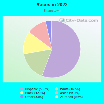
- 23,45855.7%Hispanic or Latino
- 6,93416.5%White
- 5,45312.9%Black
- 4,72111.2%Asian
- 1,2783.0%Some other race
- 2660.6%Two or more races

Distribution of median household income
![Distribution of median household income]()
- 644Less than $10,000
- 1,445$10,000 to $19,999
- 2,390$20,000 to $29,999
- 1,566$30,000 to $39,999
- 2,675$40,000 to $49,999
- 1,097$50,000 to $59,999
- 1,280$60,000 to $74,999
- 2,140$75,000 to $99,999
- 1,503$100,000 to $124,999
- 725$125,000 to $149,999
- 1,438$150,000 to $199,999
- 1,003$200,000 or more

Distribution of owner-occupied house/condo value
![Distribution of owner-occupied house/condo value]()
- 1,431Less than $50,000
- 5,530$50,000 to $99,999
- 994$100,000 to $149,999
- 1,637$150,000 to $199,999
- 2,320$200,000 to $249,999
- 2,177$250,000 to $299,999
- 1,051$300,000 to $399,999
- 340$400,000 to $499,999
- 632$500,000 to $749,999
- 460$1,000,000 or more

Distribution of rent paid by renters
![Distribution of rent paid by renters]()
- 203Less than $100
- 761$100 to $199
- 482$200 to $299
- 382$300 to $399
- 338$400 to $499
- 1,271$500 to $599
- 1,057$600 to $699
- 2,727$700 to $799
- 1,775$800 to $899
- 1,359$900 to $999
- 1,850$1,000 to $1,249
- 1,542$1,250 to $1,499
- 882$1,500 to $1,999
- 2,098$2,000 or more

Median rent in 2022:
| Sharpstown: | $1,039 |
| Houston: | $1,089 |
| Males: | 20,476 |
| Females: | 19,764 |
Males:
| This neighborhood: | 35.2 years |
| Whole city: | 34.4 years |
| This neighborhood: | 34.7 years |
| Whole city: | 34.7 years |
Average household size:
| Sharpstown: | 5.3 people |
| Houston: | 2.4 people |
Percentage of family households:
| Sharpstown: | 57.4% |
| Houston: | 43.0% |
| Here: | 42.9% |
| Houston: | 34.7% |
Percentage of married-couple families with children (among all households):
| Sharpstown: | 18.3% |
| Houston: | 23.3% |
Percentage of single-mother households (among all households):
| Sharpstown: | 18.7% |
| Houston: | 13.9% |
Percentage of never married males 15 years old and over:
Percentage of never married females 15 years old and over:
| Sharpstown: | 22.8% |
| Houston: | 22.9% |
Percentage of never married females 15 years old and over:
| Sharpstown: | 22.4% |
| city: | 21.2% |
Percentage of people that speak English not well or not at all:
| Sharpstown: | 28.5% |
| Houston: | 15.9% |
Percentage of people born in this state:
Percentage of people born in another U.S. state:
Percentage of native residents but born outside the U.S.:
Percentage of foreign born residents:
| Here: | 37.6% |
| Houston: | 51.1% |
Percentage of people born in another U.S. state:
| Sharpstown: | 11.7% |
| Houston: | 17.7% |
Percentage of native residents but born outside the U.S.:
| Here: | 2.8% |
| city: | 1.8% |
Percentage of foreign born residents:
| Here: | 47.9% |
| Houston: | 29.4% |
Owner-occupied
Renter-occupied

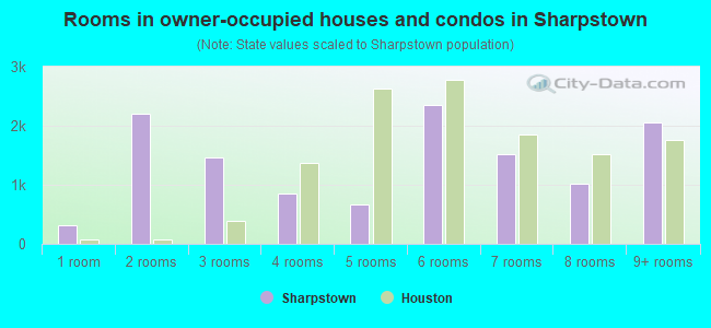
- Rooms in owner-occupied houses and condos in Sharpstown
- 3061 room
- 2,2072 rooms
- 1,4673 rooms
- 8454 rooms
- 6725 rooms
- 2,3536 rooms
- 1,5127 rooms
- 1,0228 rooms
- 2,0579+ rooms
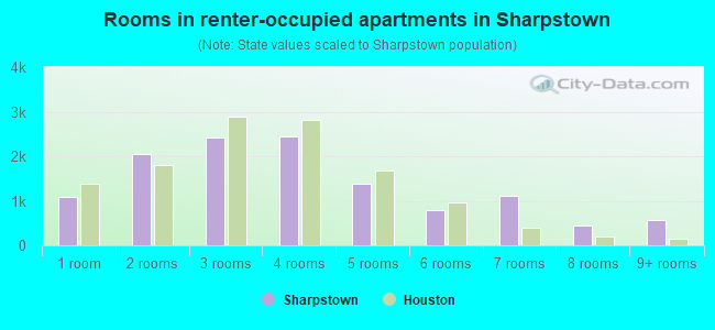
- Rooms in renter-occupied apartments in Sharpstown
- 1,0881 room
- 2,0392 rooms
- 2,4163 rooms
- 2,4504 rooms
- 1,3875 rooms
- 7856 rooms
- 1,1197 rooms
- 4368 rooms
- 5589+ rooms
Owner-occupied
Renter-occupied
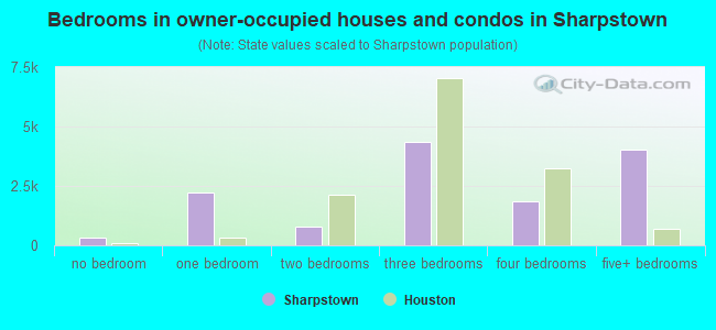
- Bedrooms in owner-occupied houses and condos in Sharpstown
- 306no bedroom
- 2,2071 bedroom
- 8022 bedrooms
- 4,3563 bedrooms
- 1,8544 bedrooms
- 4,0195+ bedrooms
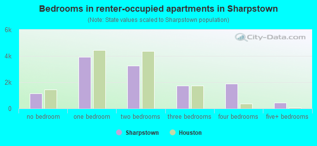
- Bedrooms in renter-occupied apartments in Sharpstown
- 1,158no bedroom
- 3,9331 bedroom
- 3,2512 bedrooms
- 1,7373 bedrooms
- 1,8954 bedrooms
- 4455+ bedrooms
Average number of cars or other vehicles available in houses/condos:
Average number of cars or other vehicles available in apartments:
| This neighborhood: | |
| Houston: |
Average number of cars or other vehicles available in apartments:
| Here: | 1.4 |
| city: | 1.3 |
Percentage of units with a mortgage:
| Sharpstown: | 38.4% |
| Houston: | 50.8% |
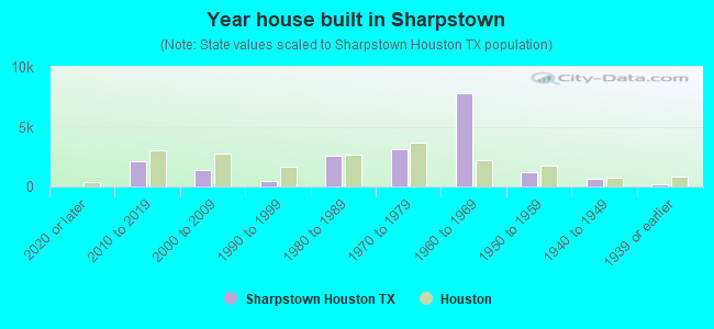
- Year house built in Sharpstown
- 02020 or later
- 2,1492010 to 2019
- 1,4212000 to 2009
- 4821990 to 1999
- 2,5791980 to 1989
- 3,0921970 to 1979
- 7,7961960 to 1969
- 1,1591950 to 1959
- 6001940 to 1949
- 2161939 or earlier
City-data.com crime index for city in 2020 (higher means more crime):
| City: | 560.9 |
| U.S. average: | 219.5 |
Travel time to work (commute)
![Travel time to work (commute)]()
- 64Less than 5 minutes
- 6945 to 9 minutes
- 1,91310 to 14 minutes
- 3,05915 to 19 minutes
- 3,72220 to 24 minutes
- 2,17025 to 29 minutes
- 7,71230 to 34 minutes
- 51735 to 39 minutes
- 1,28040 to 44 minutes
- 1,96645 to 59 minutes
- 98360 to 89 minutes
- 52790 or more minutes

Means of transportation to work
![Means of transportation to work]()
- 62.7%13,240Drove a car alone
- 16.2%3,411Carpooled
- 9.6%2,032Bus
- 1.1%236Light rail, streetcar or trolley
- 1.9%410Taxi
- 2.5%526Bicycle
- 4.5%943Walked
- 8.3%1,753Other means
- 12.0%2,533Worked at home

Time leaving home to go to work
![Time leaving home to go to work]()
- 1,48212:00 a.m. to 4:59 a.m.
- 6965:00 a.m. to 5:29 a.m.
- 4735:30 a.m. to 5:59 a.m.
- 4,3276:00 a.m. to 6:29 a.m.
- 2,4066:30 a.m. to 6:59 a.m.
- 4,2147:00 a.m. to 7:29 a.m.
- 2,0517:30 a.m. to 7:59 a.m.
- 2,9588:00 a.m. to 8:29 a.m.
- 3978:30 a.m. to 8:59 a.m.
- 1,5879:00 a.m. to 9:59 a.m.
- 40510:00 a.m. to 10:59 a.m.
- 36811:00 a.m. to 11:59 a.m.
- 1,53312:00 p.m. to 3:59 p.m.
- 1,4644:00 p.m. to 11:59 p.m.

Occupations of males:
- Percentage of males in management occupations (except farmers):
Here: 4.5% city: 10.6%
- Percentage of males in business and financial operations occupations:
Here: 2.3% city: 5.4%
- Percentage of males in computer and mathematical occupations:
Here: 6.4% city: 3.9%
- Percentage of males in architecture and engineering occupations:
Here: 1.5% city: 4.0%
- Percentage of males in education, training, and library occupations:
Here: 2.3% city: 3.1%
- Percentage of males in arts, design, entertainment, sports, and media occupations:
Here: 1.2% city: 1.6%
- Percentage of males in service occupations:
Here: 12.2% city: 12.9%
- Percentage of males in sales and office occupations:
Here: 11.3% city: 13.5%
- Percentage of males in farming, fishing, and forestry occupations:
Here: 1.1% city: 0.2%
- Percentage of males in construction, extraction, and maintenance occupations:
Here: 31.4% city: 15.7%
- Percentage of males in production occupations:
Here: 4.6% city: 6.0%
- Percentage of males in transportation occupations:
Here: 9.7% city: 6.1%
- Percentage of males in material moving occupations:
Here: 1.6% city: 5.4%
Occupations of females:
- Percentage of females in management occupations (except farmers):
Here: 2.2% city: 8.6%
- Percentage of females in business and financial operations occupations:
Here: 7.8% city: 6.8%
- Percentage of females in community and social services occupations:
Here: 1.3% city: 1.8%
- Percentage of females in education, training, and library occupations:
Here: 5.3% city: 8.5%
- Percentage of females in arts, design, entertainment, sports, and media occupations:
Here: 2.6% city: 2.0%
- Percentage of females in healthcare practitioners and technical occupations:
Here: 5.3% city: 8.1%
- Percentage of females in service occupations:
Here: 40.2% city: 23.8%
- Percentage of females in sales and office occupations:
Here: 27.2% city: 26.6%
- Percentage of females in construction, extraction, and maintenance occupations:
Here: 1.5% city: 0.7%
- Percentage of females in production occupations:
Here: 1.6% city: 2.6%
- Percentage of females in material moving occupations:
Here: 2.1% city: 2.5%
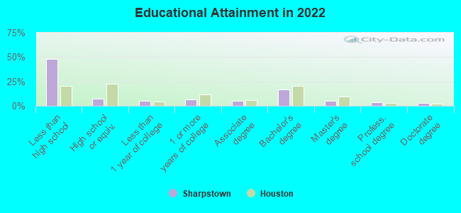
Education in this neighborhood (subdivision or community):
- Percentage of people 3 years and older in K-12 schools:
Sharpstown: 32.8% Houston: 16.6%
- Percentage of people 3 years and older in undergraduate colleges:
Sharpstown: 8.7% Houston: 4.6%
- Percentage of people 3 years and older in grad. or professional schools:
Sharpstown: 1.7% Houston: 1.6%
- Percentage of students K-12 enrolled in private schools:
Sharpstown: 23.5% Houston: 9.0%
Percentage of population below poverty level:
| Sharpstown: | 22.5% |
| Houston: | 20.7% |
Median year renter moved in (as recorded in 2022):
| Sharpstown: | 2016 |
| Houston: | 2020 |
Percentage of married-couple families with both working:
| Sharpstown: | 76.6% |
| Houston: | 54.9% |
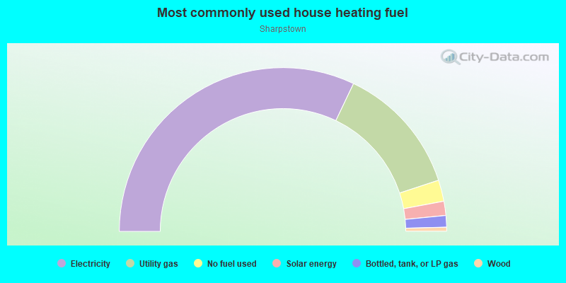
- 64.2%Electricity
- 25.7%Utility gas
- 4.2%No fuel used
- 2.8%Solar energy
- 2.3%Bottled, tank, or LP gas
- 0.8%Wood
Highways in this neighborhood:
US Hwy 59 (Southwest Fwy)
Length: 4.74 miles
Direction: SW-NE
Address range: 10812 to 11011
Direction: SW-NE
Address range: 10812 to 11011
US Hwy 59 (Hov US 59)
Length: 1.79 miles
Direction: SW-NE
Direction: SW-NE
Roads and streets:
Bellaire Blvd
Length: 4.37 miles
Direction: E-W
Address range: 6302 to 9983
Direction: E-W
Address range: 6302 to 9983
Beechnut St
Length: 3.41 miles
Directions: E-W, SE-NW, SW-NE
Address range: 6800 to 9599
Directions: E-W, SE-NW, SW-NE
Address range: 6800 to 9599
Neff St
Length: 3.26 miles
Directions: E-W, N-S, SE-NW
Address range: 6302 to 9599
Directions: E-W, N-S, SE-NW
Address range: 6302 to 9599
Harwin Dr
Length: 2.88 miles
Directions: E-W, SE-NW, SW-NE
Address range: 6520 to 9998
Directions: E-W, SE-NW, SW-NE
Address range: 6520 to 9998
Roos Rd
Length: 2.78 miles
Directions: E-W, SE-NW
Address range: 6302 to 9499
Directions: E-W, SE-NW
Address range: 6302 to 9499
Sharpview Dr
Length: 2.75 miles
Directions: E-W, SE-NW, SW-NE
Address range: 6302 to 9699
Directions: E-W, SE-NW, SW-NE
Address range: 6302 to 9699
Leader St
Length: 2.75 miles
Directions: E-W, SE-NW, SW-NE
Address range: 6300 to 9499
Directions: E-W, SE-NW, SW-NE
Address range: 6300 to 9499
Fondren Rd
Length: 2.64 miles
Directions: N-S, SE-NW, SW-NE
Address range: 5600 to 8399
Directions: N-S, SE-NW, SW-NE
Address range: 5600 to 8399
Mobud Dr
Length: 2.38 miles
Directions: E-W, SE-NW
Address range: 6300 to 8999
Directions: E-W, SE-NW
Address range: 6300 to 8999
S Gessner Rd
Length: 2.37 miles
Directions: N-S, SE-NW
Address range: 5700 to 8399
Directions: N-S, SE-NW
Address range: 5700 to 8399
Triola Ln
Length: 2.33 miles
Directions: E-W, N-S, SE-NW, SW-NE
Address range: 6700 to 9699
Directions: E-W, N-S, SE-NW, SW-NE
Address range: 6700 to 9699
Carvel Ln
Length: 2.30 miles
Directions: E-W, SE-NW, SW-NE
Address range: 6600 to 9499
Directions: E-W, SE-NW, SW-NE
Address range: 6600 to 9499
Langdon Ln
Length: 2.26 miles
Directions: E-W, SE-NW, SW-NE
Address range: 6600 to 9699
Directions: E-W, SE-NW, SW-NE
Address range: 6600 to 9699
Edgemoor Dr
Length: 2.11 miles
Directions: E-W, SE-NW
Address range: 6300 to 8899
Directions: E-W, SE-NW
Address range: 6300 to 8899
Stroud Dr
Length: 2.10 miles
Directions: E-W, SE-NW
Address range: 6400 to 9937
Directions: E-W, SE-NW
Address range: 6400 to 9937
Clarewood Dr
Length: 2.05 miles
Directions: E-W, SE-NW
Address range: 6296 to 8799
Directions: E-W, SE-NW
Address range: 6296 to 8799
Rowan Ln
Length: 1.98 miles
Directions: E-W, SE-NW
Address range: 6302 to 9499
Directions: E-W, SE-NW
Address range: 6302 to 9499
Sands Point Dr
Length: 1.87 miles
Directions: E-W, SE-NW, SW-NE
Address range: 6402 to 8699
Directions: E-W, SE-NW, SW-NE
Address range: 6402 to 8699
Sharpcrest St
Length: 1.86 miles
Directions: E-W, SE-NW
Address range: 7900 to 9939
Directions: E-W, SE-NW
Address range: 7900 to 9939
Corporate Dr
Length: 1.77 miles
Directions: N-S, SW-NE
Address range: 5866 to 7999
Directions: N-S, SW-NE
Address range: 5866 to 7999
Bintliff Dr
Length: 1.61 miles
Directions: N-S, SE-NW, SW-NE
Address range: 5600 to 7999
Directions: N-S, SE-NW, SW-NE
Address range: 5600 to 7999
Concho St
Length: 1.57 miles
Directions: E-W, SE-NW, SW-NE
Address range: 6800 to 9199
Directions: E-W, SE-NW, SW-NE
Address range: 6800 to 9199
Hendon Ln
Length: 1.54 miles
Directions: E-W, SE-NW, SW-NE
Address range: 6700 to 9699
Directions: E-W, SE-NW, SW-NE
Address range: 6700 to 9699
Hillcroft St (Hillcroft Ave)
Length: 1.49 miles
Directions: N-S, SE-NW
Address range: 5600 to 7298
Directions: N-S, SE-NW
Address range: 5600 to 7298
Redding Rd
Length: 1.46 miles
Directions: N-S, SE-NW
Address range: 5901 to 7999
Directions: N-S, SE-NW
Address range: 5901 to 7999
Hazen St
Length: 1.45 miles
Directions: E-W, SE-NW, SW-NE
Address range: 6800 to 9199
Directions: E-W, SE-NW, SW-NE
Address range: 6800 to 9199
Bonhomme Rd
Length: 1.39 miles
Directions: N-S, SE-NW
Address range: 5600 to 8622
Directions: N-S, SE-NW
Address range: 5600 to 8622
Bellerive Dr
Length: 1.27 miles
Directions: E-W, SE-NW
Address range: 7000 to 7899
Directions: E-W, SE-NW
Address range: 7000 to 7899
Town Park Dr
Length: 1.25 miles
Directions: E-W, SW-NE
Address range: 8700 to 9869
Directions: E-W, SW-NE
Address range: 8700 to 9869
Marinette Dr
Length: 1.16 miles
Directions: N-S, SE-NW
Address range: 6100 to 7923
Directions: N-S, SE-NW
Address range: 6100 to 7923
Pella Dr
Length: 1.15 miles
Directions: N-S, SW-NE
Address range: 6900 to 8399
Directions: N-S, SW-NE
Address range: 6900 to 8399
Bissonnet St
Length: 1.12 miles
Direction: SW-NE
Address range: 6300 to 7099
Direction: SW-NE
Address range: 6300 to 7099
de Moss Dr
Length: 1.10 miles
Direction: E-W
Address range: 6500 to 8599
Direction: E-W
Address range: 6500 to 8599
Jorine Dr
Length: 1.07 miles
Direction: N-S
Address range: 7000 to 8399
Direction: N-S
Address range: 7000 to 8399
Augustine Dr
Length: 1.03 miles
Directions: N-S, SE-NW, SW-NE
Address range: 6900 to 8399
Directions: N-S, SE-NW, SW-NE
Address range: 6900 to 8399
Hornwood Dr
Length: 1.01 miles
Directions: E-W, SE-NW
Address range: 6500 to 8599
Directions: E-W, SE-NW
Address range: 6500 to 8599
Osage St (Osage Rd)
Length: 1.01 miles
Directions: N-S, SE-NW
Address range: 4103 to 7499
Directions: N-S, SE-NW
Address range: 4103 to 7499
Rookin St
Length: 1.00 miles
Directions: N-S, SE-NW, SW-NE
Address range: 6000 to 7099
Directions: N-S, SE-NW, SW-NE
Address range: 6000 to 7099
Glenmont Dr
Length: 0.99 miles
Direction: E-W
Direction: E-W
Sandstone Rd (Sandstone St)
Length: 0.95 miles
Directions: E-W, N-S, SE-NW, SW-NE
Address range: 6600 to 9699
Directions: E-W, N-S, SE-NW, SW-NE
Address range: 6600 to 9699
Lugary Dr
Length: 0.95 miles
Directions: N-S, SE-NW, SW-NE
Address range: 5800 to 8299
Directions: N-S, SE-NW, SW-NE
Address range: 5800 to 8299
Tanager St
Length: 0.93 miles
Directions: E-W, SE-NW, SW-NE
Address range: 7100 to 9499
Directions: E-W, SE-NW, SW-NE
Address range: 7100 to 9499
Tarnef Dr
Length: 0.90 miles
Directions: N-S, SE-NW
Address range: 6000 to 7099
Directions: N-S, SE-NW
Address range: 6000 to 7099
Mary Bates Blvd
Length: 0.88 miles
Directions: N-S, SE-NW
Address range: 6900 to 7999
Directions: N-S, SE-NW
Address range: 6900 to 7999
Ranchester Dr
Length: 0.86 miles
Directions: N-S, SE-NW
Address range: 5810 to 6899
Directions: N-S, SE-NW
Address range: 5810 to 6899
Burning Tree Dr
Length: 0.86 miles
Directions: E-W, N-S, SE-NW, SW-NE
Address range: 5900 to 7499
Directions: E-W, N-S, SE-NW, SW-NE
Address range: 5900 to 7499
Albacore Dr
Length: 0.85 miles
Directions: N-S, SE-NW, SW-NE
Address range: 7000 to 8199
Directions: N-S, SE-NW, SW-NE
Address range: 7000 to 8199
Larkwood Dr
Length: 0.84 miles
Directions: N-S, SE-NW
Address range: 6600 to 7799
Directions: N-S, SE-NW
Address range: 6600 to 7799
Tanglewilde St (Tanglewilde Ave)
Length: 0.81 miles
Direction: N-S
Address range: 7400 to 7743
Direction: N-S
Address range: 7400 to 7743
Sandpiper Dr
Length: 0.79 miles
Directions: N-S, SW-NE
Address range: 7000 to 7999
Directions: N-S, SW-NE
Address range: 7000 to 7999
Sharpcrest Ln (Sharpcrest St)
Length: 0.78 miles
Directions: E-W, SE-NW, SW-NE
Address range: 6700 to 7199
Directions: E-W, SE-NW, SW-NE
Address range: 6700 to 7199
Kendalia Dr
Length: 0.78 miles
Directions: N-S, SE-NW
Address range: 6900 to 7999
Directions: N-S, SE-NW
Address range: 6900 to 7999
Troulon Dr
Length: 0.76 miles
Direction: E-W
Address range: 7100 to 9199
Direction: E-W
Address range: 7100 to 9199
Waldo St
Length: 0.76 miles
Directions: N-S, SE-NW
Address range: 6700 to 7399
Directions: N-S, SE-NW
Address range: 6700 to 7399
Tam O Shanter Ln
Length: 0.76 miles
Directions: N-S, SE-NW, SW-NE
Address range: 5900 to 6799
Directions: N-S, SE-NW, SW-NE
Address range: 5900 to 6799
Savoy Dr
Length: 0.75 miles
Directions: E-W, N-S, SE-NW
Address range: 5600 to 6399
Directions: E-W, N-S, SE-NW
Address range: 5600 to 6399
Reims Rd
Length: 0.69 miles
Direction: N-S
Address range: 5800 to 8599
Direction: N-S
Address range: 5800 to 8599
Barberton Dr
Length: 0.67 miles
Direction: SW-NE
Address range: 7400 to 7999
Direction: SW-NE
Address range: 7400 to 7999
Sovereign Dr
Length: 0.65 miles
Directions: N-S, SE-NW
Address range: 5808 to 6099
Directions: N-S, SE-NW
Address range: 5808 to 6099
Lacy Hill Dr
Length: 0.65 miles
Directions: N-S, SW-NE
Address range: 7000 to 7799
Directions: N-S, SW-NE
Address range: 7000 to 7799
la Roche Ln
Length: 0.61 miles
Directions: N-S, SW-NE
Address range: 7700 to 8399
Directions: N-S, SW-NE
Address range: 7700 to 8399
Eichler Dr
Length: 0.59 miles
Direction: N-S
Address range: 7000 to 7799
Direction: N-S
Address range: 7000 to 7799
Jackwood St
Length: 0.58 miles
Direction: E-W
Address range: 8600 to 9199
Direction: E-W
Address range: 8600 to 9199
Gulfton St (Gulfton Dr)
Length: 0.56 miles
Directions: E-W, SE-NW, SW-NE
Address range: 6500 to 7999
Directions: E-W, SE-NW, SW-NE
Address range: 6500 to 7999
Tours St (Tours Dr)
Length: 0.54 miles
Directions: E-W, N-S, SE-NW
Address range: 7000 to 7499
Directions: E-W, N-S, SE-NW
Address range: 7000 to 7499
Dashwood Dr
Length: 0.54 miles
Direction: E-W
Address range: 7600 to 8599
Direction: E-W
Address range: 7600 to 8599
Golf Green Cir
Length: 0.53 miles
Directions: E-W, N-S, SE-NW, SW-NE
Address range: 8000 to 8368
Directions: E-W, N-S, SE-NW, SW-NE
Address range: 8000 to 8368
Imogene St
Length: 0.50 miles
Directions: E-W, SE-NW
Address range: 8800 to 9298
Directions: E-W, SE-NW
Address range: 8800 to 9298
Regency Square Blvd
Length: 0.49 miles
Directions: E-W, N-S, SE-NW, SW-NE
Address range: 7000 to 7399
Directions: E-W, N-S, SE-NW, SW-NE
Address range: 7000 to 7399
High Star Dr
Length: 0.48 miles
Direction: E-W
Address range: 6400 to 8599
Direction: E-W
Address range: 6400 to 8599
Grape St (Grape Rd)
Length: 0.48 miles
Direction: E-W
Address range: 8800 to 9199
Direction: E-W
Address range: 8800 to 9199
Commerce Park Dr
Length: 0.48 miles
Directions: N-S, SE-NW
Address range: 8100 to 9017
Directions: N-S, SE-NW
Address range: 8100 to 9017
Prestwood Dr
Length: 0.47 miles
Directions: E-W, SE-NW
Address range: 7600 to 7999
Directions: E-W, SE-NW
Address range: 7600 to 7999
Harbor Town Dr
Length: 0.46 miles
Directions: N-S, SW-NE
Address range: 6500 to 6899
Directions: N-S, SW-NE
Address range: 6500 to 6899
Cannock Rd
Length: 0.45 miles
Directions: N-S, SE-NW
Address range: 7000 to 7499
Directions: N-S, SE-NW
Address range: 7000 to 7499
Romney Rd
Length: 0.44 miles
Direction: SW-NE
Address range: 7500 to 7799
Direction: SW-NE
Address range: 7500 to 7799
Westwood Village Dr
Length: 0.42 miles
Directions: E-W, N-S
Address range: 9000 to 9417
Directions: E-W, N-S
Address range: 9000 to 9417
Braewick Dr
Length: 0.40 miles
Directions: N-S, SE-NW
Address range: 7000 to 7499
Directions: N-S, SE-NW
Address range: 7000 to 7499
Moonmist Dr
Length: 0.40 miles
Direction: E-W
Address range: 7600 to 9799
Direction: E-W
Address range: 7600 to 9799
Scribner Rd
Length: 0.39 miles
Directions: E-W, SW-NE
Address range: 6300 to 6699
Directions: E-W, SW-NE
Address range: 6300 to 6699
Kensico Rd
Length: 0.39 miles
Direction: SW-NE
Address range: 7500 to 7799
Direction: SW-NE
Address range: 7500 to 7799
Dunlap St
Length: 0.39 miles
Directions: E-W, N-S
Address range: 6500 to 7656
Directions: E-W, N-S
Address range: 6500 to 7656
Galleon Dr
Length: 0.34 miles
Direction: SE-NW
Address range: 7100 to 7399
Direction: SE-NW
Address range: 7100 to 7399
Westline Dr
Length: 0.32 miles
Direction: N-S
Address range: 6000 to 6599
Direction: N-S
Address range: 6000 to 6599
Colony St (Colony Dr)
Length: 0.32 miles
Directions: E-W, N-S
Address range: 7700 to 8215
Directions: E-W, N-S
Address range: 7700 to 8215
Croton Rd
Length: 0.32 miles
Directions: E-W, SW-NE
Address range: 7300 to 7699
Directions: E-W, SW-NE
Address range: 7300 to 7699
Wagley St
Length: 0.31 miles
Directions: E-W, N-S
Directions: E-W, N-S
Tasco St
Length: 0.30 miles
Direction: E-W
Direction: E-W
Hiawatha Dr
Length: 0.30 miles
Direction: E-W
Address range: 7700 to 8599
Direction: E-W
Address range: 7700 to 8599
Mahoning Dr
Length: 0.30 miles
Directions: N-S, SW-NE
Address range: 7000 to 7399
Directions: N-S, SW-NE
Address range: 7000 to 7399
Braxton Dr
Length: 0.29 miles
Directions: E-W, N-S
Address range: 5600 to 5799
Directions: E-W, N-S
Address range: 5600 to 5799
Westwood Place Dr
Length: 0.27 miles
Directions: E-W, N-S
Address range: 7900 to 9699
Directions: E-W, N-S
Address range: 7900 to 9699
Sharpstown Green Cir
Length: 0.25 miles
Directions: E-W, N-S, SE-NW
Directions: E-W, N-S, SE-NW
Mc Avoy Dr
Length: 0.25 miles
Directions: N-S, SE-NW, SW-NE
Address range: 8000 to 8199
Directions: N-S, SE-NW, SW-NE
Address range: 8000 to 8199
Parkfront Dr
Length: 0.25 miles
Directions: N-S, SE-NW
Address range: 5816 to 5899
Directions: N-S, SE-NW
Address range: 5816 to 5899
Tarna Ln
Length: 0.24 miles
Directions: E-W, N-S, SW-NE
Address range: 6300 to 6499
Directions: E-W, N-S, SW-NE
Address range: 6300 to 6499
Allday Dr
Length: 0.24 miles
Directions: N-S, SE-NW
Address range: 5800 to 5999
Directions: N-S, SE-NW
Address range: 5800 to 5999
Memorial Ln
Length: 0.23 miles
Directions: N-S, SW-NE
Directions: N-S, SW-NE
Hartsdale Dr
Length: 0.23 miles
Direction: N-S
Address range: 5600 to 5799
Direction: N-S
Address range: 5600 to 5799
Parkersburg Dr
Length: 0.22 miles
Direction: N-S
Address range: 5600 to 5899
Direction: N-S
Address range: 5600 to 5899
Beryl St
Length: 0.21 miles
Direction: E-W
Address range: 6600 to 6799
Direction: E-W
Address range: 6600 to 6799
Darnell St
Length: 0.21 miles
Direction: E-W
Address range: 7300 to 7405
Direction: E-W
Address range: 7300 to 7405
Point West Dr
Length: 0.21 miles
Direction: N-S
Address range: 5912 to 6199
Direction: N-S
Address range: 5912 to 6199
Drew St
Length: 0.20 miles
Direction: N-S
Direction: N-S
Captain Dr
Length: 0.20 miles
Direction: N-S
Address range: 6900 to 7999
Direction: N-S
Address range: 6900 to 7999
United Dr
Length: 0.19 miles
Direction: E-W
Address range: 9884 to 9898
Direction: E-W
Address range: 9884 to 9898
Stoneybrook Dr
Length: 0.19 miles
Direction: N-S
Address range: 6000 to 6199
Direction: N-S
Address range: 6000 to 6199
14th St
Length: 0.19 miles
Directions: N-S, SW-NE
Directions: N-S, SW-NE
G E George St
Length: 0.18 miles
Directions: E-W, SW-NE
Directions: E-W, SW-NE
Forney Dr
Length: 0.17 miles
Direction: N-S
Address range: 5600 to 5799
Direction: N-S
Address range: 5600 to 5799
SW Memorial Hospital Tw Dr
Length: 0.17 miles
Directions: E-W, N-S, SE-NW
Directions: E-W, N-S, SE-NW
Verlie Ln
Length: 0.17 miles
Direction: N-S
Address range: 7800 to 7999
Direction: N-S
Address range: 7800 to 7999
Bellwood Ln
Length: 0.17 miles
Direction: E-W
Address range: 9200 to 9399
Direction: E-W
Address range: 9200 to 9399
Guildford Rd
Length: 0.17 miles
Directions: N-S, SW-NE
Address range: 7300 to 7399
Directions: N-S, SW-NE
Address range: 7300 to 7399
Walkway St
Length: 0.16 miles
Directions: N-S, SE-NW, SW-NE
Address range: 7100 to 7199
Directions: N-S, SE-NW, SW-NE
Address range: 7100 to 7199
Fonvilla St
Length: 0.14 miles
Direction: E-W
Address range: 7000 to 7199
Direction: E-W
Address range: 7000 to 7199
Regency Square Ct
Length: 0.14 miles
Directions: E-W, SW-NE
Address range: 7200 to 7399
Directions: E-W, SW-NE
Address range: 7200 to 7399
Bonhomme
Length: 0.14 miles
Direction: N-S
Direction: N-S
Green Ash Dr
Length: 0.13 miles
Direction: E-W
Address range: 7700 to 7799
Direction: E-W
Address range: 7700 to 7799
Torquay Ln
Length: 0.13 miles
Directions: N-S, SW-NE
Address range: 7300 to 7399
Directions: N-S, SW-NE
Address range: 7300 to 7399
Oregano Cir
Length: 0.13 miles
Direction: E-W
Address range: 9500 to 9699
Direction: E-W
Address range: 9500 to 9699
Kings Gate Cir
Length: 0.12 miles
Direction: E-W
Address range: 7200 to 7299
Direction: E-W
Address range: 7200 to 7299
Brae Acres Rd
Length: 0.12 miles
Directions: N-S, SE-NW
Address range: 8000 to 8100
Directions: N-S, SE-NW
Address range: 8000 to 8100
Hillcroft Tc Ten Dr
Length: 0.12 miles
Directions: E-W, N-S, SW-NE
Directions: E-W, N-S, SW-NE
Caraway Ln (Caraway Cir)
Length: 0.12 miles
Direction: E-W
Address range: 9500 to 9699
Direction: E-W
Address range: 9500 to 9699
Tarragon Ln
Length: 0.11 miles
Direction: E-W
Address range: 6500 to 9699
Direction: E-W
Address range: 6500 to 9699
Robert Hanna Dr
Length: 0.11 miles
Direction: E-W
Direction: E-W
Windwater Pkwy S
Length: 0.11 miles
Direction: E-W
Direction: E-W
Carew St
Length: 0.10 miles
Direction: E-W
Address range: 7200 to 7299
Direction: E-W
Address range: 7200 to 7299
Pyron Way
Length: 0.10 miles
Direction: N-S
Address range: 7000 to 7099
Direction: N-S
Address range: 7000 to 7099
Heilig Rd
Length: 0.10 miles
Direction: N-S
Address range: 7400 to 7499
Direction: N-S
Address range: 7400 to 7499
Coyle
Length: 0.09 miles
Direction: N-S
Direction: N-S
Brou Ln
Length: 0.09 miles
Direction: N-S
Address range: 7300 to 7399
Direction: N-S
Address range: 7300 to 7399
Huddler St
Length: 0.09 miles
Direction: N-S
Address range: 7400 to 7499
Direction: N-S
Address range: 7400 to 7499
Sylmar Rd
Length: 0.09 miles
Direction: E-W
Address range: 6700 to 6799
Direction: E-W
Address range: 6700 to 6799
Gold Tee Dr
Length: 0.08 miles
Direction: E-W
Address range: 6500 to 8234
Direction: E-W
Address range: 6500 to 8234
Hillcroft Tc One Dr
Length: 0.07 miles
Direction: N-S
Direction: N-S
Stroud Dr (Stroud)
Length: 0.07 miles
Direction: E-W
Address range: 8512 to 8599
Direction: E-W
Address range: 8512 to 8599
Westward
Length: 0.06 miles
Directions: N-S, SW-NE
Address range: 6382 to 6499
Directions: N-S, SW-NE
Address range: 6382 to 6499
Cadawac Rd
Length: 0.06 miles
Direction: N-S
Address range: 8100 to 8199
Direction: N-S
Address range: 8100 to 8199
Basil Ln
Length: 0.06 miles
Direction: N-S
Address range: 7500 to 7699
Direction: N-S
Address range: 7500 to 7699
Burning Tree Dr (Burning Tree)
Length: 0.06 miles
Direction: N-S
Address range: 7250 to 7299
Direction: N-S
Address range: 7250 to 7299
Brandon's Way
Length: 0.05 miles
Direction: N-S
Direction: N-S
Alief Rd
Length: 0.05 miles
Directions: E-W, SW-NE
Address range: 10000 to 10199
Directions: E-W, SW-NE
Address range: 10000 to 10199
Robert Hanna Loop
Length: 0.05 miles
Directions: N-S, SE-NW
Directions: N-S, SE-NW
Hillcroft Tc Nine Dr
Length: 0.04 miles
Directions: N-S, SE-NW, SW-NE
Directions: N-S, SE-NW, SW-NE
Bob White Dr
Length: 0.04 miles
Direction: N-S
Address range: 8100 to 8199
Direction: N-S
Address range: 8100 to 8199
Sharpstown Center
Length: 0.04 miles
Direction: N-S
Address range: 100 to 1099
Direction: N-S
Address range: 100 to 1099
Hillcroft Tc Two Dr
Length: 0.04 miles
Direction: E-W
Direction: E-W
W Holcombe Blvd
Length: 0.04 miles
Direction: E-W
Direction: E-W
Hillcroft Tc Three Dr
Length: 0.03 miles
Direction: SE-NW
Direction: SE-NW
Hillcroft Tc Eight Dr
Length: 0.03 miles
Direction: E-W
Direction: E-W
Darnell St (Darnell Cir)
Length: 0.03 miles
Direction: N-S
Address range: 7407 to 7427
Direction: N-S
Address range: 7407 to 7427
Concho
Length: 0.03 miles
Direction: E-W
Direction: E-W
Hillcroft Tc Seven Dr
Length: 0.03 miles
Direction: E-W
Direction: E-W
Gold Tee Ct
Length: 0.02 miles
Direction: N-S
Direction: N-S
Railroad features:
Southern Pacific RR
Length: 2.89 miles
Direction: E-W
Direction: E-W
Other features:
Brays Byu
Length: 0.06 miles
Directions: N-S, SE-NW
Directions: N-S, SE-NW
Wennington Byu
Length: 0.01 miles
Direction: SW-NE
Direction: SW-NE