Sherwood (Sherwood Forest) neighborhood in Baton Rouge, Louisiana (LA), 70815, 70816 detailed profile
Settings
X


Business Search - 14 Million verified businesses
Area: 3.978 square miles
Population: 16,622
Population density:
| Sherwood (Sherwood Forest): | 4,178 people per square mile |
| Baton Rouge: | 2,882 people per square mile |

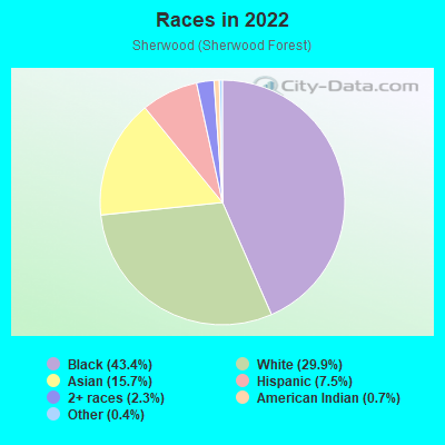
- 7,79243.4%Black
- 5,38029.9%White
- 2,82715.7%Asian
- 1,3427.5%Hispanic or Latino
- 4222.3%Two or more races
- 1280.7%American Indian
- 730.4%Some other race
Distribution of median household income
![Distribution of median household income]()
- 780Less than $10,000
- 840$10,000 to $19,999
- 596$20,000 to $29,999
- 885$30,000 to $39,999
- 706$40,000 to $49,999
- 672$50,000 to $59,999
- 388$60,000 to $74,999
- 652$75,000 to $99,999
- 964$100,000 to $124,999
- 572$125,000 to $149,999
- 435$150,000 to $199,999
- 691$200,000 or more

Distribution of owner-occupied house/condo value
![Distribution of owner-occupied house/condo value]()
- 1,410Less than $50,000
- 948$50,000 to $99,999
- 665$100,000 to $149,999
- 1,350$150,000 to $199,999
- 2,023$200,000 to $249,999
- 808$250,000 to $299,999
- 388$300,000 to $399,999
- 99$400,000 to $499,999
- 151$500,000 to $749,999
- 283$1,000,000 or more

Distribution of rent paid by renters
![Distribution of rent paid by renters]()
- 305Less than $100
- 406$100 to $199
- 211$200 to $299
- 238$300 to $399
- 511$400 to $499
- 525$500 to $599
- 600$600 to $699
- 2,176$700 to $799
- 455$800 to $899
- 1,272$900 to $999
- 686$1,000 to $1,249
- 269$1,250 to $1,499
- 557$1,500 to $1,999
- 599$2,000 or more

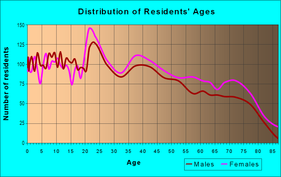
| Males: | 7,623 |
| Females: | 8,999 |
Males:
| This neighborhood: | 36.2 years |
| Whole city: | 29.6 years |
| This neighborhood: | 38.8 years |
| Whole city: | 32.8 years |
Average household size:
| Sherwood (Sherwood Forest): | 2.8 people |
| Baton Rouge: | 2.3 people |
Percentage of family households:
| Sherwood (Sherwood Forest): | 53.6% |
| Baton Rouge: | 36.6% |
| Here: | 54.6% |
| Baton Rouge: | 27.8% |
Percentage of married-couple families with children (among all households):
| Sherwood (Sherwood Forest): | 22.4% |
| Baton Rouge: | 15.1% |
Percentage of single-mother households (among all households):
| Sherwood (Sherwood Forest): | 14.3% |
| Baton Rouge: | 22.4% |
Percentage of never married males 15 years old and over:
Percentage of never married females 15 years old and over:
| Sherwood (Sherwood Forest): | 16.2% |
| Baton Rouge: | 27.3% |
Percentage of never married females 15 years old and over:
| Sherwood (Sherwood Forest): | 20.0% |
| city: | 27.2% |
Percentage of people that speak English not well or not at all:
| Sherwood (Sherwood Forest): | 5.3% |
| Baton Rouge: | 1.8% |
Percentage of people born in this state:
Percentage of people born in another U.S. state:
Percentage of native residents but born outside the U.S.:
Percentage of foreign born residents:
| Here: | 67.3% |
| Baton Rouge: | 74.7% |
Percentage of people born in another U.S. state:
| Sherwood (Sherwood Forest): | 17.2% |
| Baton Rouge: | 17.8% |
Percentage of native residents but born outside the U.S.:
| Here: | 1.6% |
| city: | 0.5% |
Percentage of foreign born residents:
| Here: | 14.0% |
| Baton Rouge: | 7.0% |
Owner-occupied
Renter-occupied

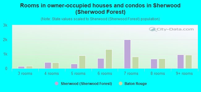
- Rooms in owner-occupied houses and condos in Sherwood <
> - 01 room
- 112 rooms
- 1453 rooms
- 4194 rooms
- 3245 rooms
- 6996 rooms
- 1,9917 rooms
- 6528 rooms
- 9569+ rooms
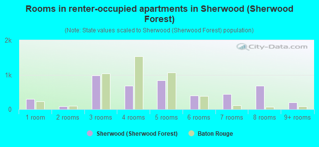
- Rooms in renter-occupied apartments in Sherwood <
> - 3041 room
- 872 rooms
- 9743 rooms
- 6794 rooms
- 8405 rooms
- 4006 rooms
- 4397 rooms
- 6868 rooms
- 2059+ rooms
Owner-occupied
Renter-occupied
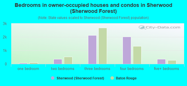
- Bedrooms in owner-occupied houses and condos in Sherwood <
> - 11no bedroom
- 611 bedroom
- 3532 bedrooms
- 2,1273 bedrooms
- 2,0234 bedrooms
- 3595+ bedrooms
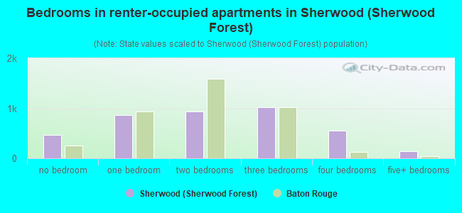
- Bedrooms in renter-occupied apartments in Sherwood <
> - 464no bedroom
- 8601 bedroom
- 9382 bedrooms
- 1,0153 bedrooms
- 5584 bedrooms
- 1405+ bedrooms
Average number of cars or other vehicles available in houses/condos:
Average number of cars or other vehicles available in apartments:
| This neighborhood: | 2.1 |
| Baton Rouge: | 1.7 |
Average number of cars or other vehicles available in apartments:
| Here: | |
| city: |
Percentage of units with a mortgage:
| Sherwood (Sherwood Forest): | 72.2% |
| Baton Rouge: | 56.3% |
Average estimated value of detached houses in 2022 (82.6% of all units):
| Sherwood (Sherwood Forest): | $228,522 |
| Louisiana: | $273,555 |
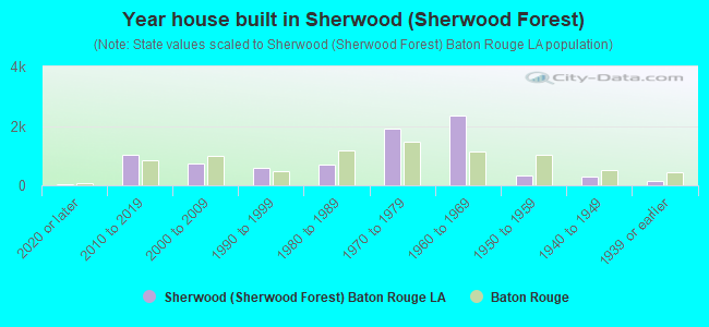
- Year house built in Sherwood <
> - 402020 or later
- 1,0132010 to 2019
- 7472000 to 2009
- 5851990 to 1999
- 6841980 to 1989
- 1,9261970 to 1979
- 2,3611960 to 1969
- 3181950 to 1959
- 3041940 to 1949
- 1421939 or earlier
City-data.com crime index for city in 2020 (higher means more crime):
| City: | 544.1 |
| U.S. average: | 219.5 |
Travel time to work (commute)
![Travel time to work (commute)]()
- 99Less than 5 minutes
- 4635 to 9 minutes
- 84010 to 14 minutes
- 1,77815 to 19 minutes
- 1,49420 to 24 minutes
- 92525 to 29 minutes
- 96530 to 34 minutes
- 5235 to 39 minutes
- 10340 to 44 minutes
- 63845 to 59 minutes
- 26760 to 89 minutes
- 8990 or more minutes

Means of transportation to work
![Means of transportation to work]()
- 77.2%6,001Drove a car alone
- 13.4%1,043Carpooled
- 1.6%123Bus
- 0.3%25Bicycle
- 2.6%199Walked
- 4.9%378Other means
- 9.7%751Worked at home

Time leaving home to go to work
![Time leaving home to go to work]()
- 22812:00 a.m. to 4:59 a.m.
- 3845:00 a.m. to 5:29 a.m.
- 3955:30 a.m. to 5:59 a.m.
- 8426:00 a.m. to 6:29 a.m.
- 6796:30 a.m. to 6:59 a.m.
- 4467:00 a.m. to 7:29 a.m.
- 9137:30 a.m. to 7:59 a.m.
- 8908:00 a.m. to 8:29 a.m.
- 6418:30 a.m. to 8:59 a.m.
- 4699:00 a.m. to 9:59 a.m.
- 3610:00 a.m. to 10:59 a.m.
- 32611:00 a.m. to 11:59 a.m.
- 69912:00 p.m. to 3:59 p.m.
- 6534:00 p.m. to 11:59 p.m.

Occupations of males:
- Percentage of males in management occupations (except farmers):
Here: 8.5% city: 9.5%
- Percentage of males in business and financial operations occupations:
Here: 1.6% city: 3.6%
- Percentage of males in computer and mathematical occupations:
Here: 2.5% city: 3.0%
- Percentage of males in architecture and engineering occupations:
Here: 4.1% city: 4.2%
- Percentage of males in education, training, and library occupations:
Here: 4.8% city: 6.9%
- Percentage of males in arts, design, entertainment, sports, and media occupations:
Here: 5.8% city: 2.5%
- Percentage of males in healthcare practitioners and technical occupations:
Here: 9.7% city: 3.0%
- Percentage of males in service occupations:
Here: 13.2% city: 16.2%
- Percentage of males in sales and office occupations:
Here: 8.3% city: 12.7%
- Percentage of males in construction, extraction, and maintenance occupations:
Here: 8.6% city: 8.7%
- Percentage of males in production occupations:
Here: 2.3% city: 6.5%
- Percentage of males in transportation occupations:
Here: 17.3% city: 6.6%
- Percentage of males in material moving occupations:
Here: 6.6% city: 7.0%
Occupations of females:
- Percentage of females in management occupations (except farmers):
Here: 10.2% city: 8.6%
- Percentage of females in business and financial operations occupations:
Here: 1.4% city: 4.9%
- Percentage of females in computer and mathematical occupations:
Here: 2.7% city: 1.9%
- Percentage of females in community and social services occupations:
Here: 2.8% city: 3.1%
- Percentage of females in legal occupations:
Here: 2.7% city: 1.5%
- Percentage of females in education, training, and library occupations:
Here: 14.2% city: 10.7%
- Percentage of females in arts, design, entertainment, sports, and media occupations:
Here: 1.5% city: 2.3%
- Percentage of females in healthcare practitioners and technical occupations:
Here: 16.7% city: 7.6%
- Percentage of females in service occupations:
Here: 24.3% city: 24.5%
- Percentage of females in sales and office occupations:
Here: 19.5% city: 26.5%
- Percentage of females in production occupations:
Here: 1.8% city: 1.8%
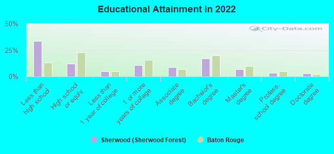
Education in this neighborhood (subdivision or community):
- Percentage of people 3 years and older in K-12 schools:
Sherwood (Sherwood Forest): 34.7% Baton Rouge: 14.3%
- Percentage of people 3 years and older in undergraduate colleges:
Sherwood (Sherwood Forest): 7.3% Baton Rouge: 14.0%
- Percentage of people 3 years and older in grad. or professional schools:
Sherwood (Sherwood Forest): 3.7% Baton Rouge: 2.5%
- Percentage of students K-12 enrolled in private schools:
Sherwood (Sherwood Forest): 78.8% Baton Rouge: 22.0%
Percentage of population below poverty level:
| Sherwood (Sherwood Forest): | 12.6% |
| Baton Rouge: | 22.4% |
Median year owner moved in (as recorded in 2022):
| Sherwood (Sherwood Forest): | 2005 |
| Baton Rouge: | 2007 |
Percentage of married-couple families with both working:
| Sherwood (Sherwood Forest): | 104.4% |
| Baton Rouge: | 80.7% |
- 59.7%Electricity
- 32.7%Utility gas
- 5.3%Bottled, tank, or LP gas
- 2.4%No fuel used
Limited-access highways (interstate or state) in this neighborhood:
I- 12
Length: 0.29 miles
Directions: E-W, N-S
Directions: E-W, N-S
Highways in this neighborhood:
Florida Blvd (US Hwy 190)
Length: 4.13 miles
Direction: E-W
Address range: 9880 to 11899
Direction: E-W
Address range: 9880 to 11899
State Rte 426 (Old Hammond Hwy)
Length: 1.85 miles
Directions: E-W, SW-NE
Address range: 11100 to 13299
Directions: E-W, SW-NE
Address range: 11100 to 13299
Roads and streets:
Goodwood Blvd
Length: 4.83 miles
Directions: E-W, N-S, SE-NW, SW-NE
Address range: 10727 to 13999
Directions: E-W, N-S, SE-NW, SW-NE
Address range: 10727 to 13999
Mollylea Dr
Length: 2.03 miles
Directions: E-W, N-S, SE-NW
Address range: 10474 to 12699
Directions: E-W, N-S, SE-NW
Address range: 10474 to 12699
Sherwood Forest Blvd
Length: 1.53 miles
Directions: N-S, SE-NW
Address range: 100 to 1799
Directions: N-S, SE-NW
Address range: 100 to 1799
S Sherwood Forest Dr
Length: 1.37 miles
Direction: N-S
Direction: N-S
Archery Dr
Length: 1.29 miles
Directions: E-W, SE-NW
Address range: 11300 to 12799
Directions: E-W, SE-NW
Address range: 11300 to 12799
S Flannery Rd
Length: 1.19 miles
Direction: N-S
Address range: 100 to 1260
Direction: N-S
Address range: 100 to 1260
Sherbrook Dr
Length: 1.15 miles
Directions: E-W, SE-NW
Address range: 11300 to 12699
Directions: E-W, SE-NW
Address range: 11300 to 12699
Parkwood Dr
Length: 0.98 miles
Directions: E-W, SE-NW, SW-NE
Address range: 11400 to 12699
Directions: E-W, SE-NW, SW-NE
Address range: 11400 to 12699
Woodcliff Dr
Length: 0.94 miles
Directions: E-W, N-S, SE-NW, SW-NE
Address range: 300 to 1399
Directions: E-W, N-S, SE-NW, SW-NE
Address range: 300 to 1399
N Harrells Ferry Rd
Length: 0.91 miles
Direction: E-W
Address range: 11400 to 12499
Direction: E-W
Address range: 11400 to 12499
Arlingford Ave
Length: 0.83 miles
Directions: E-W, SE-NW
Address range: 12700 to 13499
Directions: E-W, SE-NW
Address range: 12700 to 13499
Sheraton Dr
Length: 0.77 miles
Directions: E-W, SE-NW, SW-NE
Address range: 10900 to 11999
Directions: E-W, SE-NW, SW-NE
Address range: 10900 to 11999
Fairhaven Dr
Length: 0.73 miles
Direction: E-W
Address range: 11600 to 12799
Direction: E-W
Address range: 11600 to 12799
Sylvan Dr
Length: 0.70 miles
Directions: N-S, SE-NW
Address range: 300 to 1199
Directions: N-S, SE-NW
Address range: 300 to 1199
Havenwood Dr
Length: 0.69 miles
Directions: N-S, SE-NW
Address range: 600 to 1599
Directions: N-S, SE-NW
Address range: 600 to 1599
Brookshire Ave
Length: 0.68 miles
Directions: E-W, SW-NE
Address range: 12200 to 12799
Directions: E-W, SW-NE
Address range: 12200 to 12799
E Sheraton Ave
Length: 0.67 miles
Direction: E-W
Address range: 12200 to 12799
Direction: E-W
Address range: 12200 to 12799
Major Oaks Dr
Length: 0.67 miles
Directions: E-W, SE-NW, SW-NE
Address range: 10800 to 11299
Directions: E-W, SE-NW, SW-NE
Address range: 10800 to 11299
E Glenhaven Dr
Length: 0.66 miles
Directions: E-W, SE-NW
Address range: 12000 to 12799
Directions: E-W, SE-NW
Address range: 12000 to 12799
Warwick Ave
Length: 0.66 miles
Directions: E-W, N-S, SW-NE
Address range: 12200 to 12799
Directions: E-W, N-S, SW-NE
Address range: 12200 to 12799
S Sherwood Forest Blvd
Length: 0.65 miles
Directions: E-W, N-S, SW-NE
Address range: 1800 to 2399
Directions: E-W, N-S, SW-NE
Address range: 1800 to 2399
E Millburn Ave
Length: 0.63 miles
Direction: E-W
Address range: 12200 to 12799
Direction: E-W
Address range: 12200 to 12799
Glenhaven Dr
Length: 0.61 miles
Directions: E-W, N-S, SW-NE
Address range: 11100 to 11799
Directions: E-W, N-S, SW-NE
Address range: 11100 to 11799
Stockton Dr
Length: 0.60 miles
Directions: N-S, SW-NE
Address range: 300 to 999
Directions: N-S, SW-NE
Address range: 300 to 999
Blvd de Province
Length: 0.54 miles
Directions: N-S, SE-NW, SW-NE
Address range: 1700 to 12058
Directions: N-S, SE-NW, SW-NE
Address range: 1700 to 12058
Trammell Dr
Length: 0.54 miles
Directions: N-S, SE-NW, SW-NE
Address range: 500 to 1299
Directions: N-S, SE-NW, SW-NE
Address range: 500 to 1299
Elwick Dr
Length: 0.53 miles
Directions: N-S, SE-NW
Address range: 2100 to 2699
Directions: N-S, SE-NW
Address range: 2100 to 2699
King Richard Dr
Length: 0.50 miles
Directions: E-W, N-S, SE-NW, SW-NE
Address range: 11400 to 11999
Directions: E-W, N-S, SE-NW, SW-NE
Address range: 11400 to 11999
W Robin Hood Dr
Length: 0.50 miles
Directions: E-W, N-S, SE-NW
Address range: 10800 to 11299
Directions: E-W, N-S, SE-NW
Address range: 10800 to 11299
E Robinhood Dr
Length: 0.49 miles
Direction: E-W
Address range: 12300 to 12799
Direction: E-W
Address range: 12300 to 12799
Little John Dr
Length: 0.47 miles
Directions: N-S, SW-NE
Address range: 100 to 599
Directions: N-S, SW-NE
Address range: 100 to 599
Robinhood Dr
Length: 0.47 miles
Direction: E-W
Address range: 11300 to 11799
Direction: E-W
Address range: 11300 to 11799
Katherine Ave
Length: 0.44 miles
Directions: E-W, N-S, SE-NW, SW-NE
Address range: 13600 to 14099
Directions: E-W, N-S, SE-NW, SW-NE
Address range: 13600 to 14099
Buckingham Ave
Length: 0.44 miles
Directions: E-W, N-S, SE-NW
Address range: 12200 to 12699
Directions: E-W, N-S, SE-NW
Address range: 12200 to 12699
S Burgess Dr
Length: 0.44 miles
Direction: N-S
Address range: 600 to 1199
Direction: N-S
Address range: 600 to 1199
Manorwood Dr
Length: 0.43 miles
Directions: E-W, N-S, SE-NW
Address range: 11300 to 11799
Directions: E-W, N-S, SE-NW
Address range: 11300 to 11799
Elva Dr
Length: 0.43 miles
Directions: N-S, SW-NE
Address range: 12000 to 12399
Directions: N-S, SW-NE
Address range: 12000 to 12399
Westbrook Dr
Length: 0.43 miles
Directions: N-S, SW-NE
Address range: 600 to 1199
Directions: N-S, SW-NE
Address range: 600 to 1199
Millburn Dr
Length: 0.42 miles
Directions: E-W, SW-NE
Address range: 11400 to 20034
Directions: E-W, SW-NE
Address range: 11400 to 20034
Ranchwood Dr
Length: 0.41 miles
Directions: E-W, N-S, SE-NW
Address range: 400 to 10899
Directions: E-W, N-S, SE-NW
Address range: 400 to 10899
Nassau Dr
Length: 0.40 miles
Directions: N-S, SE-NW
Address range: 100 to 499
Directions: N-S, SE-NW
Address range: 100 to 499
Lockhaven Ave
Length: 0.40 miles
Directions: E-W, SE-NW
Address range: 12400 to 12799
Directions: E-W, SE-NW
Address range: 12400 to 12799
S Tinley Dr
Length: 0.38 miles
Directions: N-S, SE-NW
Address range: 700 to 1199
Directions: N-S, SE-NW
Address range: 700 to 1199
Worthington Ave
Length: 0.38 miles
Directions: E-W, N-S, SE-NW, SW-NE
Address range: 10900 to 11299
Directions: E-W, N-S, SE-NW, SW-NE
Address range: 10900 to 11299
Sandringham Ave
Length: 0.38 miles
Direction: E-W
Address range: 10500 to 10999
Direction: E-W
Address range: 10500 to 10999
Castlebury Dr
Length: 0.37 miles
Directions: N-S, SW-NE
Address range: 1100 to 1599
Directions: N-S, SW-NE
Address range: 1100 to 1599
Braeburn Dr
Length: 0.37 miles
Directions: N-S, SE-NW, SW-NE
Address range: 1000 to 1399
Directions: N-S, SE-NW, SW-NE
Address range: 1000 to 1399
Erlanger Dr
Length: 0.37 miles
Directions: N-S, SE-NW, SW-NE
Address range: 1800 to 1999
Directions: N-S, SE-NW, SW-NE
Address range: 1800 to 1999
Inverrary Dr
Length: 0.35 miles
Directions: E-W, N-S, SE-NW, SW-NE
Address range: 2400 to 2599
Directions: E-W, N-S, SE-NW, SW-NE
Address range: 2400 to 2599
Jennifer Lynn Ave
Length: 0.35 miles
Directions: E-W, SW-NE
Address range: 12900 to 13199
Directions: E-W, SW-NE
Address range: 12900 to 13199
Bellridge Dr
Length: 0.34 miles
Directions: E-W, N-S, SE-NW, SW-NE
Address range: 1600 to 1899
Directions: E-W, N-S, SE-NW, SW-NE
Address range: 1600 to 1899
Armstrong Dr
Length: 0.33 miles
Directions: E-W, N-S, SE-NW, SW-NE
Address range: 12100 to 12399
Directions: E-W, N-S, SE-NW, SW-NE
Address range: 12100 to 12399
Voorhies Dr
Length: 0.33 miles
Direction: N-S
Address range: 500 to 1099
Direction: N-S
Address range: 500 to 1099
Mc Gehee Dr
Length: 0.32 miles
Direction: N-S
Address range: 100 to 499
Direction: N-S
Address range: 100 to 499
Bellfort Dr
Length: 0.32 miles
Directions: N-S, SE-NW
Address range: 1500 to 1899
Directions: N-S, SE-NW
Address range: 1500 to 1899
Ashbourne Dr
Length: 0.31 miles
Directions: N-S, SW-NE
Address range: 1100 to 11398
Directions: N-S, SW-NE
Address range: 1100 to 11398
Effringham Ave
Length: 0.31 miles
Directions: E-W, SW-NE
Address range: 10600 to 10999
Directions: E-W, SW-NE
Address range: 10600 to 10999
Kimmeridge Dr
Length: 0.31 miles
Directions: N-S, SE-NW
Address range: 300 to 799
Directions: N-S, SE-NW
Address range: 300 to 799
N Bellrose Dr
Length: 0.31 miles
Directions: N-S, SE-NW
Address range: 1500 to 1899
Directions: N-S, SE-NW
Address range: 1500 to 1899
Dabney Dr
Length: 0.31 miles
Directions: E-W, N-S, SW-NE
Address range: 1800 to 2099
Directions: E-W, N-S, SW-NE
Address range: 1800 to 2099
Bellarbor Dr
Length: 0.30 miles
Direction: E-W
Address range: 10900 to 11199
Direction: E-W
Address range: 10900 to 11199
Gebhart Dr
Length: 0.30 miles
Directions: E-W, N-S, SW-NE
Address range: 12100 to 12399
Directions: E-W, N-S, SW-NE
Address range: 12100 to 12399
Leighwood Ave
Length: 0.29 miles
Directions: E-W, SE-NW
Address range: 13600 to 13998
Directions: E-W, SE-NW
Address range: 13600 to 13998
Shermoor Dr
Length: 0.28 miles
Directions: E-W, SW-NE
Address range: 10500 to 10799
Directions: E-W, SW-NE
Address range: 10500 to 10799
Queensbury Ave
Length: 0.28 miles
Direction: E-W
Address range: 12200 to 12499
Direction: E-W
Address range: 12200 to 12499
Wingate Dr
Length: 0.28 miles
Direction: N-S
Address range: 300 to 499
Direction: N-S
Address range: 300 to 499
Wilton Dr
Length: 0.28 miles
Direction: N-S
Address range: 300 to 499
Direction: N-S
Address range: 300 to 499
Kay Dr
Length: 0.28 miles
Direction: N-S
Address range: 300 to 499
Direction: N-S
Address range: 300 to 499
Faircrest Ave
Length: 0.27 miles
Directions: E-W, SE-NW
Address range: 12100 to 12303
Directions: E-W, SE-NW
Address range: 12100 to 12303
Parnell Ave
Length: 0.26 miles
Direction: E-W
Address range: 12600 to 12799
Direction: E-W
Address range: 12600 to 12799
S Locksley Dr
Length: 0.25 miles
Directions: N-S, SE-NW
Address range: 300 to 499
Directions: N-S, SE-NW
Address range: 300 to 499
Shelby Dr
Length: 0.25 miles
Direction: N-S
Address range: 100 to 399
Direction: N-S
Address range: 100 to 399
Allan Dr
Length: 0.25 miles
Direction: N-S
Address range: 199 to 398
Direction: N-S
Address range: 199 to 398
Burton Ave
Length: 0.25 miles
Directions: E-W, SE-NW, SW-NE
Address range: 10900 to 11099
Directions: E-W, SE-NW, SW-NE
Address range: 10900 to 11099
Darwin Blvd
Length: 0.25 miles
Directions: E-W, SE-NW, SW-NE
Address range: 13500 to 13599
Directions: E-W, SE-NW, SW-NE
Address range: 13500 to 13599
Marlbrook Dr
Length: 0.24 miles
Directions: N-S, SE-NW
Address range: 800 to 1199
Directions: N-S, SE-NW
Address range: 800 to 1199
Pelham Dr
Length: 0.23 miles
Directions: E-W, N-S, SW-NE
Address range: 1400 to 1599
Directions: E-W, N-S, SW-NE
Address range: 1400 to 1599
Torrey Pine Dr
Length: 0.23 miles
Directions: E-W, N-S, SE-NW, SW-NE
Address range: 2300 to 2599
Directions: E-W, N-S, SE-NW, SW-NE
Address range: 2300 to 2599
Donovan Ct
Length: 0.23 miles
Directions: E-W, N-S, SW-NE
Address range: 200 to 399
Directions: E-W, N-S, SW-NE
Address range: 200 to 399
Waverland Dr
Length: 0.23 miles
Direction: E-W
Address range: 10700 to 10999
Direction: E-W
Address range: 10700 to 10999
Glenwild Dr
Length: 0.23 miles
Direction: N-S
Address range: 400 to 699
Direction: N-S
Address range: 400 to 699
Charington Ave
Length: 0.22 miles
Directions: E-W, SW-NE
Address range: 10900 to 11299
Directions: E-W, SW-NE
Address range: 10900 to 11299
Wenham Ave
Length: 0.22 miles
Directions: E-W, SW-NE
Address range: 13100 to 13399
Directions: E-W, SW-NE
Address range: 13100 to 13399
Dartmoor Dr
Length: 0.22 miles
Directions: N-S, SW-NE
Address range: 700 to 999
Directions: N-S, SW-NE
Address range: 700 to 999
Sinclair Dr
Length: 0.21 miles
Directions: N-S, SW-NE
Address range: 800 to 1199
Directions: N-S, SW-NE
Address range: 800 to 1199
Tinley Dr
Length: 0.21 miles
Direction: N-S
Address range: 300 to 599
Direction: N-S
Address range: 300 to 599
Fairhope Way
Length: 0.21 miles
Directions: E-W, SE-NW
Address range: 12301 to 12499
Directions: E-W, SE-NW
Address range: 12301 to 12499
Stokley Pl
Length: 0.20 miles
Directions: E-W, N-S, SE-NW, SW-NE
Address range: 1100 to 1499
Directions: E-W, N-S, SE-NW, SW-NE
Address range: 1100 to 1499
E Parnell Ave
Length: 0.20 miles
Direction: E-W
Address range: 13200 to 13399
Direction: E-W
Address range: 13200 to 13399
Brinwood Ave
Length: 0.20 miles
Directions: E-W, SE-NW
Address range: 700 to 999
Directions: E-W, SE-NW
Address range: 700 to 999
Comal Dr
Length: 0.20 miles
Direction: E-W
Address range: 11900 to 12099
Direction: E-W
Address range: 11900 to 12099
Berwick Ave
Length: 0.20 miles
Direction: E-W
Address range: 13200 to 13399
Direction: E-W
Address range: 13200 to 13399
Pebblebrook Dr
Length: 0.19 miles
Directions: N-S, SW-NE
Address range: 401 to 599
Directions: N-S, SW-NE
Address range: 401 to 599
Montgomery Dr
Length: 0.19 miles
Directions: N-S, SW-NE
Address range: 1400 to 1599
Directions: N-S, SW-NE
Address range: 1400 to 1599
Fairham Dr
Length: 0.19 miles
Directions: E-W, N-S, SW-NE
Address range: 2500 to 2599
Directions: E-W, N-S, SW-NE
Address range: 2500 to 2599
Friar Tuck Dr
Length: 0.19 miles
Direction: N-S
Address range: 100 to 299
Direction: N-S
Address range: 100 to 299
Parnell Dr
Length: 0.18 miles
Direction: E-W
Address range: 12300 to 12499
Direction: E-W
Address range: 12300 to 12499
Oakford Dr
Length: 0.18 miles
Directions: E-W, N-S, SE-NW
Address range: 400 to 599
Directions: E-W, N-S, SE-NW
Address range: 400 to 599
Sharp Rd
Length: 0.18 miles
Directions: N-S, SE-NW
Address range: 100 to 1399
Directions: N-S, SE-NW
Address range: 100 to 1399
Sherwood Meadow Dr
Length: 0.18 miles
Directions: N-S, SE-NW
Address range: 2000 to 2299
Directions: N-S, SE-NW
Address range: 2000 to 2299
Kirkley Pl E
Length: 0.18 miles
Directions: N-S, SE-NW
Address range: 200 to 399
Directions: N-S, SE-NW
Address range: 200 to 399
Heather Dr
Length: 0.18 miles
Directions: N-S, SW-NE
Address range: 800 to 1199
Directions: N-S, SW-NE
Address range: 800 to 1199
Bellmeade Dr
Length: 0.17 miles
Directions: E-W, N-S, SE-NW
Address range: 1700 to 1799
Directions: E-W, N-S, SE-NW
Address range: 1700 to 1799
Silverton Dr
Length: 0.17 miles
Directions: N-S, SW-NE
Address range: 1300 to 1499
Directions: N-S, SW-NE
Address range: 1300 to 1499
King John Pl
Length: 0.17 miles
Directions: E-W, N-S, SW-NE
Address range: 200 to 12814
Directions: E-W, N-S, SW-NE
Address range: 200 to 12814
Hermadel Dr
Length: 0.17 miles
Directions: E-W, N-S, SW-NE
Address range: 1900 to 1999
Directions: E-W, N-S, SW-NE
Address range: 1900 to 1999
Todd Ave
Length: 0.17 miles
Directions: E-W, SE-NW, SW-NE
Address range: 13100 to 13299
Directions: E-W, SE-NW, SW-NE
Address range: 13100 to 13299
Foxshire Ct
Length: 0.17 miles
Direction: E-W
Address range: 11900 to 12063
Direction: E-W
Address range: 11900 to 12063
Chesterfield Dr
Length: 0.16 miles
Direction: N-S
Address range: 400 to 599
Direction: N-S
Address range: 400 to 599
Fall River Dr
Length: 0.16 miles
Directions: E-W, N-S, SE-NW
Directions: E-W, N-S, SE-NW
May Belle Ct
Length: 0.16 miles
Direction: E-W
Address range: 10800 to 10999
Direction: E-W
Address range: 10800 to 10999
Longbow Dr
Length: 0.16 miles
Direction: N-S
Address range: 100 to 299
Direction: N-S
Address range: 100 to 299
Kirkley Pl W
Length: 0.16 miles
Directions: N-S, SW-NE
Address range: 200 to 13199
Directions: N-S, SW-NE
Address range: 200 to 13199
Avants Ave
Length: 0.15 miles
Directions: E-W, SW-NE
Address range: 13200 to 13399
Directions: E-W, SW-NE
Address range: 13200 to 13399
Locksley Dr
Length: 0.14 miles
Directions: E-W, N-S, SW-NE
Address range: 200 to 499
Directions: E-W, N-S, SW-NE
Address range: 200 to 499
Doncaster Dr
Length: 0.14 miles
Directions: N-S, SE-NW, SW-NE
Address range: 700 to 899
Directions: N-S, SE-NW, SW-NE
Address range: 700 to 899
E Vieux Dr
Length: 0.14 miles
Directions: E-W, SE-NW
Address range: 11000 to 11099
Directions: E-W, SE-NW
Address range: 11000 to 11099
Fairgreen Ave
Length: 0.13 miles
Direction: E-W
Address range: 12400 to 12499
Direction: E-W
Address range: 12400 to 12499
Ferncliff Ave
Length: 0.13 miles
Directions: E-W, SE-NW
Address range: 10500 to 10699
Directions: E-W, SE-NW
Address range: 10500 to 10699
Azalea Pk Ave
Length: 0.13 miles
Direction: SW-NE
Address range: 13900 to 14099
Direction: SW-NE
Address range: 13900 to 14099
Merritt Dr
Length: 0.13 miles
Direction: N-S
Address range: 1900 to 2099
Direction: N-S
Address range: 1900 to 2099
Pebble Beach Ave
Length: 0.13 miles
Directions: E-W, SW-NE
Directions: E-W, SW-NE
Beauverde Ct
Length: 0.13 miles
Directions: E-W, N-S, SW-NE
Address range: 12000 to 12099
Directions: E-W, N-S, SW-NE
Address range: 12000 to 12099
Trudy Dr
Length: 0.13 miles
Direction: N-S
Address range: 300 to 499
Direction: N-S
Address range: 300 to 499
Wellington Dr
Length: 0.12 miles
Directions: N-S, SE-NW
Address range: 1300 to 1499
Directions: N-S, SE-NW
Address range: 1300 to 1499
Bristol Ave
Length: 0.12 miles
Directions: E-W, SE-NW
Address range: 12600 to 12699
Directions: E-W, SE-NW
Address range: 12600 to 12699
Holt Dr
Length: 0.12 miles
Direction: SE-NW
Address range: 700 to 899
Direction: SE-NW
Address range: 700 to 899
Reulet Ave
Length: 0.11 miles
Directions: SE-NW, SW-NE
Address range: 11400 to 11499
Directions: SE-NW, SW-NE
Address range: 11400 to 11499
Eileen Dr
Length: 0.11 miles
Directions: N-S, SW-NE
Address range: 300 to 499
Directions: N-S, SW-NE
Address range: 300 to 499
W Bellridge Dr
Length: 0.11 miles
Directions: N-S, SE-NW
Address range: 1500 to 1599
Directions: N-S, SE-NW
Address range: 1500 to 1599
Bellglade Dr
Length: 0.10 miles
Directions: N-S, SE-NW
Address range: 1500 to 1599
Directions: N-S, SE-NW
Address range: 1500 to 1599
Hedgewood Dr
Length: 0.10 miles
Direction: N-S
Address range: 800 to 999
Direction: N-S
Address range: 800 to 999
Hardwick Dr
Length: 0.10 miles
Direction: N-S
Direction: N-S
Tifton Dr
Length: 0.09 miles
Directions: N-S, SE-NW, SW-NE
Address range: 800 to 999
Directions: N-S, SE-NW, SW-NE
Address range: 800 to 999
Province Pl
Length: 0.09 miles
Direction: E-W
Address range: 12000 to 12099
Direction: E-W
Address range: 12000 to 12099
Russeau Ct
Length: 0.09 miles
Direction: E-W
Address range: 13400 to 13499
Direction: E-W
Address range: 13400 to 13499
Ashbourne Dr W
Length: 0.09 miles
Direction: E-W
Address range: 11200 to 11299
Direction: E-W
Address range: 11200 to 11299
S Havenpark Ct
Length: 0.08 miles
Direction: E-W
Address range: 10900 to 10999
Direction: E-W
Address range: 10900 to 10999
Havenpark Dr
Length: 0.08 miles
Direction: N-S
Direction: N-S
Norma Ct
Length: 0.08 miles
Direction: E-W
Address range: 13000 to 13099
Direction: E-W
Address range: 13000 to 13099
Chapel View Ct
Length: 0.08 miles
Directions: N-S, SW-NE
Address range: 200 to 299
Directions: N-S, SW-NE
Address range: 200 to 299
Turtle Ct
Length: 0.08 miles
Direction: E-W
Address range: 13400 to 13499
Direction: E-W
Address range: 13400 to 13499
Northstar Ct
Length: 0.08 miles
Direction: E-W
Address range: 189 to 13498
Direction: E-W
Address range: 189 to 13498
Shadydale Dr
Length: 0.08 miles
Directions: N-S, SE-NW
Address range: 300 to 399
Directions: N-S, SE-NW
Address range: 300 to 399
E Parnell Dr
Length: 0.08 miles
Direction: E-W
Address range: 13400 to 13499
Direction: E-W
Address range: 13400 to 13499
Ashbourne Dr E
Length: 0.07 miles
Directions: E-W, SW-NE
Address range: 11300 to 11399
Directions: E-W, SW-NE
Address range: 11300 to 11399
W Sherwood Meadow Ave
Length: 0.07 miles
Directions: E-W, SE-NW
Address range: 2032 to 11699
Directions: E-W, SE-NW
Address range: 2032 to 11699
Vieux Dr
Length: 0.07 miles
Directions: E-W, N-S, SE-NW, SW-NE
Address range: 600 to 699
Directions: E-W, N-S, SE-NW, SW-NE
Address range: 600 to 699
Ashby Ave
Length: 0.07 miles
Direction: E-W
Direction: E-W
N Waverland Dr
Length: 0.07 miles
Directions: E-W, N-S, SW-NE
Address range: 300 to 399
Directions: E-W, N-S, SW-NE
Address range: 300 to 399
Fox Croft Blvd
Length: 0.07 miles
Directions: N-S, SW-NE
Address range: 1700 to 1799
Directions: N-S, SW-NE
Address range: 1700 to 1799
Glenway Dr
Length: 0.07 miles
Direction: N-S
Direction: N-S
Amberdale Dr
Length: 0.06 miles
Direction: N-S
Direction: N-S
Fairgate Dr
Length: 0.06 miles
Directions: N-S, SE-NW, SW-NE
Directions: N-S, SE-NW, SW-NE
Steib Dr
Length: 0.06 miles
Direction: N-S
Direction: N-S
Burgess Pl
Length: 0.06 miles
Direction: N-S
Address range: 300 to 399
Direction: N-S
Address range: 300 to 399
Kirkley Pl N
Length: 0.06 miles
Direction: E-W
Address range: 13100 to 13199
Direction: E-W
Address range: 13100 to 13199
Braewood Ave
Length: 0.05 miles
Directions: N-S, SE-NW
Address range: 700 to 799
Directions: N-S, SE-NW
Address range: 700 to 799
Sherwood Hollow Ct
Length: 0.05 miles
Direction: E-W
Address range: 11600 to 11699
Direction: E-W
Address range: 11600 to 11699
Camelot Ave
Length: 0.05 miles
Directions: E-W, SW-NE
Address range: 13200 to 13299
Directions: E-W, SW-NE
Address range: 13200 to 13299
Foxton Ct
Length: 0.05 miles
Direction: N-S
Address range: 1700 to 1799
Direction: N-S
Address range: 1700 to 1799
Armstrong Cir
Length: 0.05 miles
Direction: SE-NW
Address range: 2400 to 2499
Direction: SE-NW
Address range: 2400 to 2499
Overbrook Ave
Length: 0.04 miles
Direction: E-W
Address range: 13200 to 13299
Direction: E-W
Address range: 13200 to 13299
Settlement Ct
Length: 0.04 miles
Direction: E-W
Address range: 12500 to 15571
Direction: E-W
Address range: 12500 to 15571
Robindale Cir
Length: 0.04 miles
Direction: N-S
Address range: 300 to 399
Direction: N-S
Address range: 300 to 399
Sherwood Valley Ct
Length: 0.04 miles
Direction: E-W
Address range: 11600 to 11699
Direction: E-W
Address range: 11600 to 11699
Dunstan Cir
Length: 0.04 miles
Direction: N-S
Address range: 300 to 399
Direction: N-S
Address range: 300 to 399
S Faircrest Ct
Length: 0.04 miles
Direction: N-S
Address range: 2700 to 2799
Direction: N-S
Address range: 2700 to 2799
Harrington Ct
Length: 0.03 miles
Direction: E-W
Direction: E-W
Fairwood Ct
Length: 0.03 miles
Direction: SW-NE
Direction: SW-NE
Other features:
Lively Byu
Length: 3.34 miles
Directions: E-W, N-S, SE-NW, SW-NE
Directions: E-W, N-S, SE-NW, SW-NE
Jones Crk
Length: 2.80 miles
Directions: E-W, N-S, SE-NW, SW-NE
Directions: E-W, N-S, SE-NW, SW-NE