South Park neighborhood in Houston, Texas (TX), 77033 detailed profile
Settings
X


Business Search - 14 Million verified businesses
Area: 4.372 square miles
Population: 23,236
Population density:
| South Park: | 5,314 people per square mile |
| Houston: | 3,977 people per square mile |

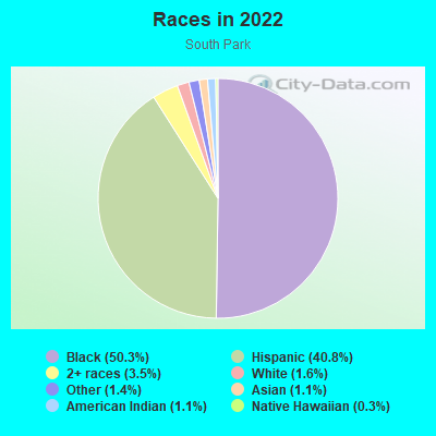
- 12,87550.3%Black
- 10,44440.8%Hispanic or Latino
- 9053.5%Two or more races
- 4081.6%White
- 3511.4%Some other race
- 2701.1%American Indian
- 2871.1%Asian
- 790.3%Native Hawaiian and Other
Pacific Islander
Distribution of median household income
![Distribution of median household income]()
- 955Less than $10,000
- 1,316$10,000 to $19,999
- 1,122$20,000 to $29,999
- 1,490$30,000 to $39,999
- 985$40,000 to $49,999
- 691$50,000 to $59,999
- 489$60,000 to $74,999
- 711$75,000 to $99,999
- 469$100,000 to $124,999
- 486$125,000 to $149,999
- 294$150,000 to $199,999
- 210$200,000 or more

Distribution of owner-occupied house/condo value
![Distribution of owner-occupied house/condo value]()
- 2,713Less than $50,000
- 3,229$50,000 to $99,999
- 935$100,000 to $149,999
- 959$150,000 to $199,999
- 650$200,000 to $249,999
- 443$250,000 to $299,999
- 118$300,000 to $399,999
- 331$400,000 to $499,999
- 735$500,000 to $749,999
- 128$750,000 to $999,999
- 183$1,000,000 or more

Distribution of rent paid by renters
![Distribution of rent paid by renters]()
- 1,365Less than $100
- 2,583$100 to $199
- 1,358$200 to $299
- 1,933$300 to $399
- 815$400 to $499
- 1,183$500 to $599
- 328$600 to $699
- 939$700 to $799
- 582$800 to $899
- 690$900 to $999
- 732$1,000 to $1,249
- 478$1,250 to $1,499
- 1,083$1,500 to $1,999
- 279$2,000 or more

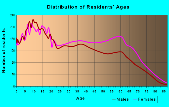
| Males: | 11,361 |
| Females: | 11,875 |
Males:
| This neighborhood: | 34.5 years |
| Whole city: | 34.4 years |
| This neighborhood: | 37.9 years |
| Whole city: | 34.7 years |
Average household size:
| South Park: | 6.2 people |
| Houston: | 2.4 people |
Percentage of family households:
| South Park: | 44.6% |
| Houston: | 43.0% |
| Here: | 31.5% |
| Houston: | 34.7% |
Percentage of married-couple families with children (among all households):
| South Park: | 17.4% |
| Houston: | 23.3% |
Percentage of single-mother households (among all households):
| South Park: | 12.3% |
| Houston: | 13.9% |
Percentage of never married males 15 years old and over:
Percentage of never married females 15 years old and over:
| South Park: | 22.7% |
| Houston: | 22.9% |
Percentage of never married females 15 years old and over:
| South Park: | 20.1% |
| city: | 21.2% |
Percentage of people that speak English not well or not at all:
| South Park: | 13.4% |
| Houston: | 15.9% |
Percentage of people born in this state:
Percentage of people born in another U.S. state:
Percentage of native residents but born outside the U.S.:
Percentage of foreign born residents:
| Here: | 70.2% |
| Houston: | 51.1% |
Percentage of people born in another U.S. state:
| South Park: | 11.0% |
| Houston: | 17.7% |
Percentage of native residents but born outside the U.S.:
| Here: | 1.3% |
| city: | 1.8% |
Percentage of foreign born residents:
| Here: | 18.4% |
| Houston: | 29.4% |
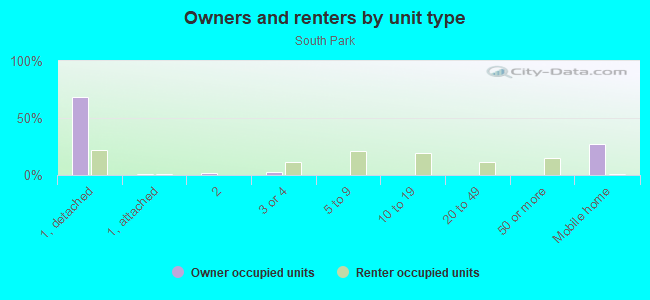
Owner-occupied
Renter-occupied

- Rooms in owner-occupied houses and condos in South Park
- 2981 room
- 202 rooms
- 1433 rooms
- 7704 rooms
- 1,2415 rooms
- 1,6806 rooms
- 6737 rooms
- 4558 rooms
- 5359+ rooms
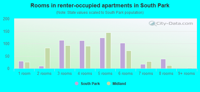
- Rooms in renter-occupied apartments in South Park
- 2971 room
- 2832 rooms
- 3553 rooms
- 1,0944 rooms
- 9045 rooms
- 1,0216 rooms
- 7587 rooms
- 1528 rooms
- 1779+ rooms
Owner-occupied
Renter-occupied
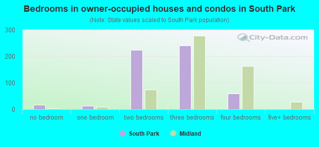
- Bedrooms in owner-occupied houses and condos in South Park
- 298no bedroom
- 1961 bedroom
- 1,2162 bedrooms
- 2,9373 bedrooms
- 7494 bedrooms
- 1995+ bedrooms
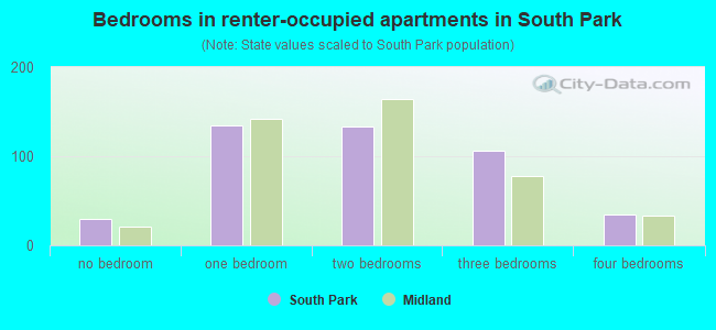
- Bedrooms in renter-occupied apartments in South Park
- 221no bedroom
- 4271 bedroom
- 1,0482 bedrooms
- 1,3553 bedrooms
- 5624 bedrooms
- 05+ bedrooms
Average number of cars or other vehicles available in houses/condos:
Average number of cars or other vehicles available in apartments:
| This neighborhood: | 1.9 |
| Houston: | 2.0 |
Average number of cars or other vehicles available in apartments:
| Here: | 1.4 |
| city: | 1.3 |
Percentage of units with a mortgage:
| South Park: | 30.9% |
| Houston: | 50.8% |
Average estimated value of detached houses in 2022 (89.4% of all units):
| South Park: | $113,671 |
| Houston: | $368,067 |
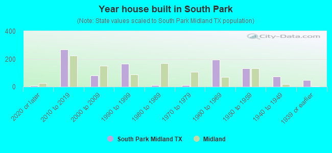
- Year house built in South Park
- 9042020 or later
- 2362010 to 2019
- 7122000 to 2009
- 3321990 to 1999
- 1,1671980 to 1989
- 1,0441970 to 1979
- 1,1951960 to 1969
- 3,9191950 to 1959
- 1,1771940 to 1949
- 4701939 or earlier
City-data.com crime index for city in 2020 (higher means more crime):
| City: | 560.9 |
| U.S. average: | 219.5 |
Travel time to work (commute)
![Travel time to work (commute)]()
- 165Less than 5 minutes
- 2115 to 9 minutes
- 66010 to 14 minutes
- 82915 to 19 minutes
- 84220 to 24 minutes
- 45325 to 29 minutes
- 1,73030 to 34 minutes
- 26135 to 39 minutes
- 20340 to 44 minutes
- 69545 to 59 minutes
- 39560 to 89 minutes
- 21990 or more minutes

Means of transportation to work
![Means of transportation to work]()
- 76.5%5,536Drove a car alone
- 13.2%952Carpooled
- 6.8%494Bus
- 0.2%18Subway or elevated rail
- 9.1%658Light rail, streetcar or trolley
- 6.1%442Walked
- 5.1%367Other means
- 5.6%409Worked at home

Time leaving home to go to work
![Time leaving home to go to work]()
- 68912:00 a.m. to 4:59 a.m.
- 4855:00 a.m. to 5:29 a.m.
- 3775:30 a.m. to 5:59 a.m.
- 6226:00 a.m. to 6:29 a.m.
- 4916:30 a.m. to 6:59 a.m.
- 1,0357:00 a.m. to 7:29 a.m.
- 3587:30 a.m. to 7:59 a.m.
- 7678:00 a.m. to 8:29 a.m.
- 1798:30 a.m. to 8:59 a.m.
- 4009:00 a.m. to 9:59 a.m.
- 18510:00 a.m. to 10:59 a.m.
- 4811:00 a.m. to 11:59 a.m.
- 50012:00 p.m. to 3:59 p.m.
- 4414:00 p.m. to 11:59 p.m.

Occupations of males:
- Percentage of males in management occupations (except farmers):
Here: 4.3% city: 10.6%
- Percentage of males in business and financial operations occupations:
Here: 2.6% city: 5.4%
- Percentage of males in architecture and engineering occupations:
Here: 1.4% city: 4.0%
- Percentage of males in education, training, and library occupations:
Here: 1.5% city: 3.1%
- Percentage of males in healthcare practitioners and technical occupations:
Here: 1.8% city: 2.7%
- Percentage of males in service occupations:
Here: 17.3% city: 12.9%
- Percentage of males in sales and office occupations:
Here: 11.3% city: 13.5%
- Percentage of males in farming, fishing, and forestry occupations:
Here: 1.0% city: 0.2%
- Percentage of males in construction, extraction, and maintenance occupations:
Here: 23.5% city: 15.7%
- Percentage of males in production occupations:
Here: 10.0% city: 6.0%
- Percentage of males in transportation occupations:
Here: 13.3% city: 6.1%
- Percentage of males in material moving occupations:
Here: 6.7% city: 5.4%
Occupations of females:
- Percentage of females in management occupations (except farmers):
Here: 5.2% city: 8.6%
- Percentage of females in business and financial operations occupations:
Here: 7.0% city: 6.8%
- Percentage of females in legal occupations:
Here: 1.1% city: 2.0%
- Percentage of females in education, training, and library occupations:
Here: 2.9% city: 8.5%
- Percentage of females in arts, design, entertainment, sports, and media occupations:
Here: 1.4% city: 2.0%
- Percentage of females in healthcare practitioners and technical occupations:
Here: 5.4% city: 8.1%
- Percentage of females in service occupations:
Here: 43.0% city: 23.8%
- Percentage of females in sales and office occupations:
Here: 21.5% city: 26.6%
- Percentage of females in production occupations:
Here: 4.3% city: 2.6%
- Percentage of females in transportation occupations:
Here: 3.1% city: 1.2%
- Percentage of females in material moving occupations:
Here: 3.4% city: 2.5%
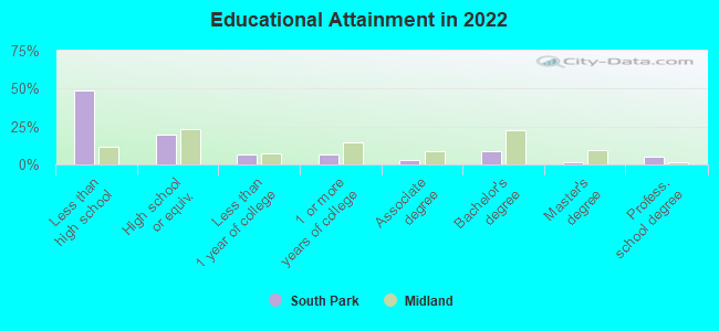
Education in this neighborhood (subdivision or community):
- Percentage of people 3 years and older in K-12 schools:
South Park: 29.9% Houston: 16.6%
- Percentage of people 3 years and older in undergraduate colleges:
South Park: 3.8% Houston: 4.6%
- Percentage of people 3 years and older in grad. or professional schools:
South Park: 2.0% Houston: 1.6%
- Percentage of students K-12 enrolled in private schools:
South Park: 87.6% Houston: 9.0%
Percentage of population below poverty level:
| South Park: | 31.8% |
| Houston: | 20.7% |
Median year owner moved in (as recorded in 2022):
| South Park: | 1999 |
| Houston: | 2010 |
Percentage of married-couple families with both working:
| South Park: | 84.3% |
| Houston: | 54.9% |
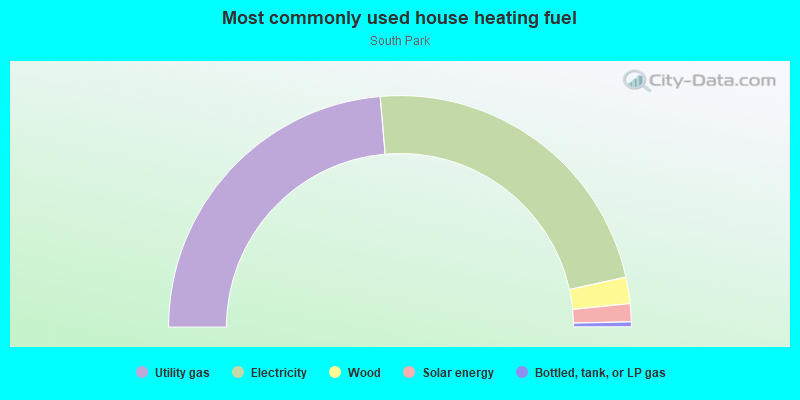
- 46.0%Utility gas
- 43.7%Electricity
- 4.9%Bottled, tank, or LP gas
- 4.7%No fuel used
- 0.7%Other fuel
Limited-access highways (interstate or state) in this neighborhood:
I- 610 (S Loop Fwy)
Length: 0.94 miles
Direction: SW-NE
Direction: SW-NE
Roads and streets:
Mykawa Rd
Length: 2.65 miles
Direction: N-S
Address range: 6801 to 8400
Direction: N-S
Address range: 6801 to 8400
Crestmont St
Length: 2.34 miles
Directions: N-S, SE-NW
Address range: 6200 to 8799
Directions: N-S, SE-NW
Address range: 6200 to 8799
S Park Blvd (Martin Luther King Jr Blvd)
Length: 2.11 miles
Direction: N-S
Address range: 7100 to 10099
Direction: N-S
Address range: 7100 to 10099
Bellfort St
Length: 2.00 miles
Direction: E-W
Address range: 5179 to 6199
Direction: E-W
Address range: 5179 to 6199
Westover St
Length: 1.82 miles
Direction: E-W
Address range: 5198 to 6199
Direction: E-W
Address range: 5198 to 6199
Southbank
Length: 1.81 miles
Direction: N-S
Address range: 6700 to 8799
Direction: N-S
Address range: 6700 to 8799
Willow Glen Dr
Length: 1.72 miles
Direction: E-W
Address range: 5100 to 6199
Direction: E-W
Address range: 5100 to 6199
Ridgeway Dr
Length: 1.72 miles
Direction: E-W
Address range: 5100 to 6199
Direction: E-W
Address range: 5100 to 6199
Kenilwood Dr
Length: 1.72 miles
Directions: E-W, SE-NW
Address range: 5100 to 6199
Directions: E-W, SE-NW
Address range: 5100 to 6199
Doulton Dr
Length: 1.67 miles
Directions: E-W, SE-NW
Address range: 5100 to 6199
Directions: E-W, SE-NW
Address range: 5100 to 6199
Doolittle Blvd
Length: 1.64 miles
Direction: E-W
Address range: 4600 to 5999
Direction: E-W
Address range: 4600 to 5999
Pershing St
Length: 1.59 miles
Direction: E-W
Address range: 4756 to 5999
Direction: E-W
Address range: 4756 to 5999
Saint Lo Rd
Length: 1.59 miles
Directions: E-W, N-S, SE-NW, SW-NE
Address range: 7200 to 9399
Directions: E-W, N-S, SE-NW, SW-NE
Address range: 7200 to 9399
Belmark St
Length: 1.56 miles
Direction: E-W
Address range: 5600 to 6199
Direction: E-W
Address range: 5600 to 6199
Beldart St
Length: 1.53 miles
Direction: E-W
Address range: 5600 to 6199
Direction: E-W
Address range: 5600 to 6199
Belcrest St
Length: 1.49 miles
Direction: E-W
Address range: 5600 to 6199
Direction: E-W
Address range: 5600 to 6199
Van Fleet St
Length: 1.45 miles
Directions: E-W, SE-NW
Address range: 4950 to 5999
Directions: E-W, SE-NW
Address range: 4950 to 5999
Belneath St
Length: 1.32 miles
Directions: E-W, N-S, SE-NW
Address range: 5400 to 6099
Directions: E-W, N-S, SE-NW
Address range: 5400 to 6099
Southwind St
Length: 1.29 miles
Direction: E-W
Address range: 4963 to 5999
Direction: E-W
Address range: 4963 to 5999
Southlea St
Length: 1.27 miles
Directions: E-W, SE-NW
Address range: 5200 to 6099
Directions: E-W, SE-NW
Address range: 5200 to 6099
Belarbor St
Length: 1.19 miles
Direction: E-W
Address range: 5600 to 6199
Direction: E-W
Address range: 5600 to 6199
Lyndhurst Dr
Length: 1.19 miles
Direction: E-W
Address range: 5300 to 6199
Direction: E-W
Address range: 5300 to 6199
Vasser Rd
Length: 1.10 miles
Directions: E-W, N-S
Address range: 5000 to 9099
Directions: E-W, N-S
Address range: 5000 to 9099
Malmedy Rd
Length: 1.06 miles
Direction: E-W
Address range: 4800 to 5699
Direction: E-W
Address range: 4800 to 5699
Reed Rd
Length: 1.04 miles
Direction: E-W
Address range: 5314 to 5899
Direction: E-W
Address range: 5314 to 5899
Glenhurst Dr
Length: 1.02 miles
Directions: E-W, SW-NE
Address range: 5700 to 6199
Directions: E-W, SW-NE
Address range: 5700 to 6199
Thrush Dr
Length: 1.01 miles
Direction: E-W
Address range: 5400 to 5899
Direction: E-W
Address range: 5400 to 5899
Sharondale Dr
Length: 1.01 miles
Directions: E-W, N-S
Address range: 7700 to 8699
Directions: E-W, N-S
Address range: 7700 to 8699
Flamingo Dr
Length: 1.00 miles
Direction: E-W
Address range: 5400 to 5899
Direction: E-W
Address range: 5400 to 5899
Hirondel St
Length: 0.96 miles
Directions: E-W, N-S
Address range: 5400 to 5899
Directions: E-W, N-S
Address range: 5400 to 5899
Jutland Rd
Length: 0.94 miles
Directions: N-S, SE-NW, SW-NE
Address range: 6800 to 7849
Directions: N-S, SE-NW, SW-NE
Address range: 6800 to 7849
Bataan Rd
Length: 0.92 miles
Directions: E-W, SE-NW, SW-NE
Address range: 4900 to 5599
Directions: E-W, SE-NW, SW-NE
Address range: 4900 to 5599
Burma Rd
Length: 0.86 miles
Direction: E-W
Address range: 4800 to 5499
Direction: E-W
Address range: 4800 to 5499
Heron Dr
Length: 0.85 miles
Directions: E-W, N-S, SW-NE
Address range: 5400 to 5899
Directions: E-W, N-S, SW-NE
Address range: 5400 to 5899
Chennault Rd
Length: 0.80 miles
Directions: E-W, SW-NE
Address range: 4900 to 5599
Directions: E-W, SW-NE
Address range: 4900 to 5599
S Wayside Dr
Length: 0.78 miles
Directions: N-S, SW-NE
Address range: 7400 to 8099
Directions: N-S, SW-NE
Address range: 7400 to 8099
Herschelwood St
Length: 0.78 miles
Direction: N-S
Address range: 7600 to 8199
Direction: N-S
Address range: 7600 to 8199
Martin Luther King Jr Blvd
Length: 0.78 miles
Directions: N-S, SE-NW
Address range: 6401 to 7099
Directions: N-S, SE-NW
Address range: 6401 to 7099
Belbay St
Length: 0.74 miles
Direction: N-S
Address range: 7600 to 8099
Direction: N-S
Address range: 7600 to 8099
Belgard St
Length: 0.73 miles
Direction: N-S
Address range: 7600 to 8099
Direction: N-S
Address range: 7600 to 8099
Silsbee
Length: 0.73 miles
Directions: E-W, N-S, SW-NE
Address range: 6600 to 7199
Directions: E-W, N-S, SW-NE
Address range: 6600 to 7199
Crestridge St
Length: 0.72 miles
Directions: E-W, N-S, SW-NE
Address range: 5800 to 6899
Directions: E-W, N-S, SW-NE
Address range: 5800 to 6899
Kassarine Pass
Length: 0.71 miles
Directions: N-S, SE-NW, SW-NE
Address range: 6400 to 7299
Directions: N-S, SE-NW, SW-NE
Address range: 6400 to 7299
Northridge Dr
Length: 0.71 miles
Direction: E-W
Address range: 5300 to 5899
Direction: E-W
Address range: 5300 to 5899
Rapido Rd
Length: 0.64 miles
Directions: E-W, SW-NE
Address range: 5000 to 5499
Directions: E-W, SW-NE
Address range: 5000 to 5499
Kirbyville St
Length: 0.61 miles
Direction: N-S
Address range: 6601 to 7199
Direction: N-S
Address range: 6601 to 7199
Southmont St
Length: 0.60 miles
Direction: E-W
Address range: 5800 to 6099
Direction: E-W
Address range: 5800 to 6099
Dieppe St
Length: 0.57 miles
Directions: E-W, SW-NE
Address range: 5000 to 5499
Directions: E-W, SW-NE
Address range: 5000 to 5499
Southridge St
Length: 0.56 miles
Direction: E-W
Address range: 5800 to 6099
Direction: E-W
Address range: 5800 to 6099
Ricky St
Length: 0.54 miles
Direction: E-W
Address range: 5500 to 5899
Direction: E-W
Address range: 5500 to 5899
Rockford Dr
Length: 0.54 miles
Directions: N-S, SW-NE
Address range: 8102 to 8699
Directions: N-S, SW-NE
Address range: 8102 to 8699
Overdale St
Length: 0.54 miles
Direction: E-W
Address range: 5700 to 5899
Direction: E-W
Address range: 5700 to 5899
Southseas St
Length: 0.54 miles
Direction: E-W
Address range: 5700 to 5999
Direction: E-W
Address range: 5700 to 5999
Schevers St
Length: 0.54 miles
Direction: E-W
Address range: 5700 to 5899
Direction: E-W
Address range: 5700 to 5899
Southtown St
Length: 0.53 miles
Directions: E-W, SE-NW
Address range: 5800 to 5999
Directions: E-W, SE-NW
Address range: 5800 to 5999
Groveton St
Length: 0.51 miles
Direction: E-W
Address range: 5500 to 5799
Direction: E-W
Address range: 5500 to 5799
Lakefield Dr
Length: 0.50 miles
Direction: E-W
Address range: 5500 to 5799
Direction: E-W
Address range: 5500 to 5799
Southcrest St
Length: 0.50 miles
Directions: E-W, SW-NE
Address range: 5800 to 6099
Directions: E-W, SW-NE
Address range: 5800 to 6099
Southford St
Length: 0.49 miles
Direction: E-W
Address range: 5800 to 5999
Direction: E-W
Address range: 5800 to 5999
Southgood St
Length: 0.47 miles
Direction: E-W
Address range: 5800 to 5999
Direction: E-W
Address range: 5800 to 5999
Wenda St
Length: 0.45 miles
Direction: E-W
Address range: 5700 to 5999
Direction: E-W
Address range: 5700 to 5999
Southington St
Length: 0.45 miles
Direction: E-W
Address range: 5800 to 5999
Direction: E-W
Address range: 5800 to 5999
Longmeadow St
Length: 0.44 miles
Directions: E-W, SE-NW
Address range: 5100 to 5499
Directions: E-W, SE-NW
Address range: 5100 to 5499
Donoho St
Length: 0.44 miles
Direction: E-W
Address range: 6000 to 6199
Direction: E-W
Address range: 6000 to 6199
Southville St
Length: 0.43 miles
Direction: E-W
Address range: 5800 to 5999
Direction: E-W
Address range: 5800 to 5999
Rue St
Length: 0.43 miles
Direction: E-W
Address range: 5500 to 5799
Direction: E-W
Address range: 5500 to 5799
Windemere St
Length: 0.41 miles
Directions: E-W, N-S, SE-NW
Address range: 5300 to 5699
Directions: E-W, N-S, SE-NW
Address range: 5300 to 5699
Wortham Way
Length: 0.40 miles
Directions: E-W, N-S, SE-NW
Address range: 6000 to 6198
Directions: E-W, N-S, SE-NW
Address range: 6000 to 6198
Cherbourg Rd
Length: 0.37 miles
Directions: E-W, N-S, SE-NW
Address range: 4700 to 5199
Directions: E-W, N-S, SE-NW
Address range: 4700 to 5199
Southmund St
Length: 0.36 miles
Directions: E-W, SW-NE
Address range: 5800 to 5999
Directions: E-W, SW-NE
Address range: 5800 to 5999
Tarawa Rd
Length: 0.35 miles
Directions: E-W, SW-NE
Address range: 5100 to 5499
Directions: E-W, SW-NE
Address range: 5100 to 5499
Southurst St
Length: 0.34 miles
Direction: E-W
Address range: 5800 to 5999
Direction: E-W
Address range: 5800 to 5999
Murphy
Length: 0.33 miles
Direction: E-W
Address range: 6000 to 6199
Direction: E-W
Address range: 6000 to 6199
Southwell St
Length: 0.28 miles
Directions: E-W, SW-NE
Address range: 5800 to 5999
Directions: E-W, SW-NE
Address range: 5800 to 5999
Osborn St
Length: 0.28 miles
Direction: E-W
Address range: 5900 to 6099
Direction: E-W
Address range: 5900 to 6099
Calais Rd
Length: 0.27 miles
Directions: N-S, SW-NE
Address range: 7201 to 7399
Directions: N-S, SW-NE
Address range: 7201 to 7399
Clearway Dr
Length: 0.26 miles
Direction: N-S
Address range: 9200 to 9399
Direction: N-S
Address range: 9200 to 9399
Elmlawn Dr
Length: 0.26 miles
Direction: E-W
Address range: 5500 to 5699
Direction: E-W
Address range: 5500 to 5699
Long Meadow St
Length: 0.26 miles
Direction: E-W
Address range: 5900 to 5999
Direction: E-W
Address range: 5900 to 5999
Peacock
Length: 0.26 miles
Direction: E-W
Address range: 5700 to 5899
Direction: E-W
Address range: 5700 to 5899
Anzio Rd
Length: 0.23 miles
Directions: E-W, SW-NE
Address range: 5200 to 5399
Directions: E-W, SW-NE
Address range: 5200 to 5399
Myrtlewood St
Length: 0.23 miles
Direction: E-W
Address range: 5300 to 5499
Direction: E-W
Address range: 5300 to 5499
Forrestal St
Length: 0.23 miles
Directions: N-S, SW-NE
Address range: 7300 to 7599
Directions: N-S, SW-NE
Address range: 7300 to 7599
Crestville St
Length: 0.22 miles
Direction: N-S
Address range: 6200 to 6599
Direction: N-S
Address range: 6200 to 6599
Waterford Dr
Length: 0.22 miles
Directions: E-W, N-S, SW-NE
Address range: 5700 to 5799
Directions: E-W, N-S, SW-NE
Address range: 5700 to 5799
Sunbeam St
Length: 0.22 miles
Direction: E-W
Address range: 5640 to 5799
Direction: E-W
Address range: 5640 to 5799
Marcy Dr
Length: 0.20 miles
Direction: N-S
Address range: 8102 to 8199
Direction: N-S
Address range: 8102 to 8199
Southlark St
Length: 0.20 miles
Direction: E-W
Address range: 5900 to 5999
Direction: E-W
Address range: 5900 to 5999
Glen Hollow Dr
Length: 0.19 miles
Direction: N-S
Address range: 8102 to 8199
Direction: N-S
Address range: 8102 to 8199
Sandhurst Dr
Length: 0.19 miles
Direction: N-S
Address range: 8102 to 8199
Direction: N-S
Address range: 8102 to 8199
Cresthill St
Length: 0.19 miles
Directions: N-S, SW-NE
Address range: 6600 to 6699
Directions: N-S, SW-NE
Address range: 6600 to 6699
Dunkirk Rd
Length: 0.19 miles
Directions: N-S, SW-NE
Address range: 7300 to 7399
Directions: N-S, SW-NE
Address range: 7300 to 7399
Ardennes St
Length: 0.18 miles
Directions: E-W, N-S, SW-NE
Address range: 7300 to 7399
Directions: E-W, N-S, SW-NE
Address range: 7300 to 7399
Eisenhower Rd
Length: 0.18 miles
Direction: SW-NE
Address range: 7300 to 7399
Direction: SW-NE
Address range: 7300 to 7399
Guadalcanal Rd
Length: 0.18 miles
Direction: SW-NE
Address range: 7300 to 7399
Direction: SW-NE
Address range: 7300 to 7399
Hurtgen Forest Rd
Length: 0.17 miles
Direction: SW-NE
Address range: 7300 to 7399
Direction: SW-NE
Address range: 7300 to 7399
Bastogne Rd
Length: 0.17 miles
Directions: E-W, SW-NE
Address range: 7300 to 7399
Directions: E-W, SW-NE
Address range: 7300 to 7399
Iwo Jima Rd
Length: 0.17 miles
Direction: SW-NE
Address range: 7300 to 7399
Direction: SW-NE
Address range: 7300 to 7399
Krueger Rd
Length: 0.16 miles
Direction: SW-NE
Address range: 7300 to 7399
Direction: SW-NE
Address range: 7300 to 7399
Le Havre Rd
Length: 0.16 miles
Direction: SW-NE
Address range: 7300 to 7399
Direction: SW-NE
Address range: 7300 to 7399
Mountbatten Rd
Length: 0.16 miles
Direction: SW-NE
Address range: 7300 to 7399
Direction: SW-NE
Address range: 7300 to 7399
Okinawa Rd
Length: 0.16 miles
Direction: SW-NE
Address range: 7300 to 7399
Direction: SW-NE
Address range: 7300 to 7399
Remegan Rd
Length: 0.15 miles
Direction: SW-NE
Address range: 7300 to 7399
Direction: SW-NE
Address range: 7300 to 7399
Teneha Dr
Length: 0.15 miles
Direction: N-S
Address range: 10150 to 10298
Direction: N-S
Address range: 10150 to 10298
Vinearbor St
Length: 0.12 miles
Direction: N-S
Address range: 8600 to 9299
Direction: N-S
Address range: 8600 to 9299
Bayfield Dr
Length: 0.12 miles
Direction: E-W
Address range: 5600 to 5699
Direction: E-W
Address range: 5600 to 5699
Calhoun Rd
Length: 0.12 miles
Directions: N-S, SW-NE
Address range: 7300 to 7356
Directions: N-S, SW-NE
Address range: 7300 to 7356
Crest St
Length: 0.11 miles
Direction: N-S
Address range: 6300 to 6399
Direction: N-S
Address range: 6300 to 6399
Faircroft Dr
Length: 0.10 miles
Direction: N-S
Address range: 9200 to 9299
Direction: N-S
Address range: 9200 to 9299
Tobruk Ln
Length: 0.09 miles
Direction: SW-NE
Address range: 7200 to 7299
Direction: SW-NE
Address range: 7200 to 7299
Sur Ct
Length: 0.06 miles
Directions: N-S, SW-NE
Address range: 7000 to 7099
Directions: N-S, SW-NE
Address range: 7000 to 7099
Kildee Park
Length: 0.06 miles
Direction: N-S
Address range: 8500 to 8599
Direction: N-S
Address range: 8500 to 8599
Medford Dr
Length: 0.04 miles
Direction: N-S
Address range: 8500 to 8599
Direction: N-S
Address range: 8500 to 8599
Beldart Ct
Length: 0.04 miles
Direction: E-W
Address range: 5400 to 5499
Direction: E-W
Address range: 5400 to 5499
Bellfort Ct
Length: 0.04 miles
Direction: N-S
Address range: 5300 to 5435
Direction: N-S
Address range: 5300 to 5435
Glenside St
Length: 0.04 miles
Direction: N-S
Address range: 8600 to 8699
Direction: N-S
Address range: 8600 to 8699
Merle St
Length: 0.03 miles
Direction: N-S
Address range: 8600 to 8699
Direction: N-S
Address range: 8600 to 8699
St Lo Rd
Length: 0.03 miles
Direction: N-S
Address range: 8600 to 8699
Direction: N-S
Address range: 8600 to 8699
Crest Ct
Length: 0.03 miles
Direction: N-S
Address range: 5900 to 5999
Direction: N-S
Address range: 5900 to 5999
Railroad features:
at and Sf Rlwy
Length: 2.41 miles
Directions: E-W, N-S, SW-NE
Directions: E-W, N-S, SW-NE
Other features:
Sims Byu
Length: 0.32 miles
Directions: E-W, SW-NE
Directions: E-W, SW-NE