Southern Mattapan neighborhood in Mattapan, Massachusetts (MA), 02126 detailed profile
Settings
X


Area: 1.146 square miles
Population: 16,412
Population density: 14,318 people per square mile

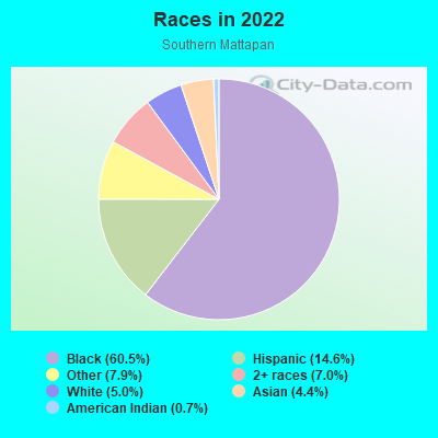
- 11,17160.5%Black
- 2,68814.6%Hispanic or Latino
- 1,4667.9%Some other race
- 1,2977.0%Two or more races
- 9155.0%White
- 8144.4%Asian
- 1220.7%American Indian
Distribution of median household income
![Distribution of median household income]()
- 442Less than $10,000
- 1,051$10,000 to $19,999
- 1,044$20,000 to $29,999
- 707$30,000 to $39,999
- 550$40,000 to $49,999
- 745$50,000 to $59,999
- 496$60,000 to $74,999
- 975$75,000 to $99,999
- 631$100,000 to $124,999
- 596$125,000 to $149,999
- 519$150,000 to $199,999
- 640$200,000 or more

Distribution of owner-occupied house/condo value
![Distribution of owner-occupied house/condo value]()
- 2,120Less than $50,000
- 903$50,000 to $99,999
- 34$100,000 to $149,999
- 154$200,000 to $249,999
- 486$250,000 to $299,999
- 571$300,000 to $399,999
- 409$400,000 to $499,999
- 898$500,000 to $749,999
- 842$750,000 to $999,999
- 1,188$1,000,000 or more

Distribution of rent paid by renters
![Distribution of rent paid by renters]()
- 253Less than $100
- 334$100 to $199
- 485$200 to $299
- 844$300 to $399
- 1,907$400 to $499
- 670$500 to $599
- 901$600 to $699
- 396$700 to $799
- 672$800 to $899
- 231$900 to $999
- 738$1,000 to $1,249
- 875$1,250 to $1,499
- 1,118$1,500 to $1,999
- 1,283$2,000 or more

| Males: | 7,190 |
| Females: | 9,222 |
| Males: | 37.5 years |
| Females: | 42.1 years |
Average household size:
| Southern Mattapan: | 4.3 people |
| Massachusetts: | 2.4 people |
Percentage of family households:
| Southern Mattapan: | 47.2% |
| Massachusetts: | 43.1% |
| Here: | 29.3% |
| Massachusetts: | 45.2% |
Percentage of married-couple families with children (among all households):
| Southern Mattapan: | 12.7% |
| Massachusetts: | 56.2% |
Percentage of single-mother households (among all households):
| Southern Mattapan: | 24.3% |
| Massachusetts: | 8.7% |
Percentage of never married males 15 years old and over:
Percentage of never married females 15 years old and over:
| Southern Mattapan: | 20.0% |
| Massachusetts: | 19.4% |
Percentage of never married females 15 years old and over:
| Southern Mattapan: | 27.6% |
| Massachusetts: | 18.4% |
Percentage of people that speak English not well or not at all:
| Southern Mattapan: | 7.7% |
| Massachusetts: | 5.2% |
Percentage of people born in this state:
Percentage of people born in another U.S. state:
Percentage of native residents but born outside the U.S.:
Percentage of foreign born residents:
| Here: | 50.2% |
| Massachusetts: | 58.6% |
Percentage of people born in another U.S. state:
| Southern Mattapan: | 10.9% |
| Massachusetts: | 20.5% |
Percentage of native residents but born outside the U.S.:
| Here: | 1.0% |
| Massachusetts: | 2.8% |
Percentage of foreign born residents:
| Here: | 37.9% |
| Massachusetts: | 18.0% |
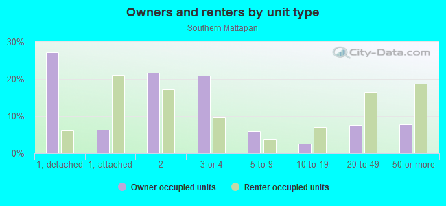
Owner-occupied
Renter-occupied

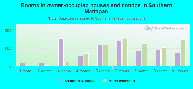
- Rooms in owner-occupied houses and condos in Southern Mattapan
- 921 room
- 852 rooms
- 7823 rooms
- 2954 rooms
- 6075 rooms
- 7056 rooms
- 4287 rooms
- 4528 rooms
- 3759+ rooms
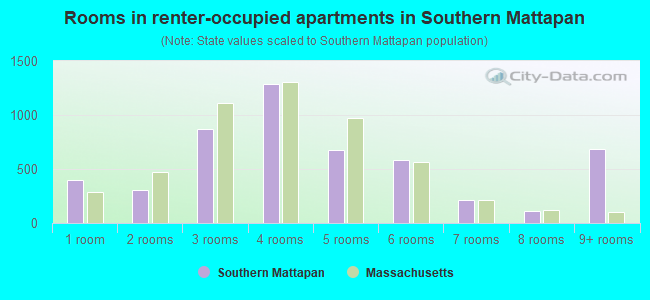
- Rooms in renter-occupied apartments in Southern Mattapan
- 4021 room
- 3062 rooms
- 8693 rooms
- 1,2884 rooms
- 6785 rooms
- 5856 rooms
- 2107 rooms
- 1088 rooms
- 6869+ rooms
Owner-occupied
Renter-occupied
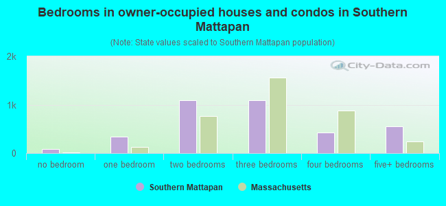
- Bedrooms in owner-occupied houses and condos in Southern Mattapan
- 92no bedroom
- 3341 bedroom
- 1,0942 bedrooms
- 1,0893 bedrooms
- 4314 bedrooms
- 5605+ bedrooms
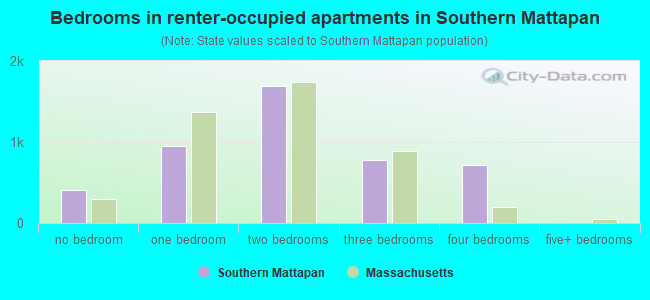
- Bedrooms in renter-occupied apartments in Southern Mattapan
- 411no bedroom
- 9511 bedroom
- 1,6972 bedrooms
- 7773 bedrooms
- 7224 bedrooms
- 05+ bedrooms
Average number of cars or other vehicles available in houses/condos:
Average number of cars or other vehicles available in apartments:
| This neighborhood: | 1.7 |
| Massachusetts: | 2.0 |
Average number of cars or other vehicles available in apartments:
| Here: | |
| Massachusetts: |
Percentage of units with a mortgage:
| Southern Mattapan: | 75.7% |
| Massachusetts: | 65.5% |
Average estimated value of detached houses in 2022 (23.3% of all units):
| Southern Mattapan: | $575,722 |
| Massachusetts: | $651,570 |

- Year house built in Southern Mattapan
- 2472020 or later
- 1,0342010 to 2019
- 5382000 to 2009
- 5571990 to 1999
- 2451980 to 1989
- 5591970 to 1979
- 8101960 to 1969
- 1,2531950 to 1959
- 8401940 to 1949
- 2,0931939 or earlier
Travel time to work (commute)
![Travel time to work (commute)]()
- 94Less than 5 minutes
- 2405 to 9 minutes
- 23810 to 14 minutes
- 60315 to 19 minutes
- 52320 to 24 minutes
- 47825 to 29 minutes
- 60030 to 34 minutes
- 11935 to 39 minutes
- 23940 to 44 minutes
- 1,21545 to 59 minutes
- 96160 to 89 minutes
- 34690 or more minutes

Means of transportation to work
![Means of transportation to work]()
- 47.7%3,401Drove a car alone
- 6.7%480Carpooled
- 12.4%882Bus
- 11.7%835Subway or elevated rail
- 3.1%221Long-distance train or commuter rail
- 11.9%847Light rail, streetcar or trolley
- 0.4%29Taxi
- 2.4%169Bicycle
- 5.5%393Walked
- 10.6%756Other means
- 13.7%975Worked at home

Time leaving home to go to work
![Time leaving home to go to work]()
- 35012:00 a.m. to 4:59 a.m.
- 1825:00 a.m. to 5:29 a.m.
- 3515:30 a.m. to 5:59 a.m.
- 5336:00 a.m. to 6:29 a.m.
- 3456:30 a.m. to 6:59 a.m.
- 7267:00 a.m. to 7:29 a.m.
- 6797:30 a.m. to 7:59 a.m.
- 6018:00 a.m. to 8:29 a.m.
- 1168:30 a.m. to 8:59 a.m.
- 5179:00 a.m. to 9:59 a.m.
- 9710:00 a.m. to 10:59 a.m.
- 7111:00 a.m. to 11:59 a.m.
- 35712:00 p.m. to 3:59 p.m.
- 5164:00 p.m. to 11:59 p.m.

Occupations of males:
- Percentage of males in management occupations (except farmers):
Here: 8.6% Massachusetts: 14.0%
- Percentage of males in business and financial operations occupations:
Here: 5.7% Massachusetts: 6.5%
- Percentage of males in life, physical, and social science occupations:
Here: 2.9% Massachusetts: 2.4%
- Percentage of males in legal occupations:
Here: 1.0% Massachusetts: 1.5%
- Percentage of males in arts, design, entertainment, sports, and media occupations:
Here: 1.4% Massachusetts: 2.2%
- Percentage of males in healthcare practitioners and technical occupations:
Here: 5.4% Massachusetts: 3.2%
- Percentage of males in service occupations:
Here: 25.2% Massachusetts: 13.5%
- Percentage of males in sales and office occupations:
Here: 11.0% Massachusetts: 14.0%
- Percentage of males in construction, extraction, and maintenance occupations:
Here: 11.9% Massachusetts: 8.2%
- Percentage of males in production occupations:
Here: 2.8% Massachusetts: 5.1%
- Percentage of males in transportation occupations:
Here: 12.3% Massachusetts: 4.9%
- Percentage of males in material moving occupations:
Here: 4.5% Massachusetts: 3.5%
Occupations of females:
- Percentage of females in management occupations (except farmers):
Here: 10.1% Massachusetts: 11.3%
- Percentage of females in business and financial operations occupations:
Here: 2.0% Massachusetts: 7.6%
- Percentage of females in computer and mathematical occupations:
Here: 1.7% Massachusetts: 2.6%
- Percentage of females in community and social services occupations:
Here: 4.5% Massachusetts: 3.1%
- Percentage of females in education, training, and library occupations:
Here: 7.9% Massachusetts: 10.9%
- Percentage of females in healthcare practitioners and technical occupations:
Here: 6.3% Massachusetts: 10.8%
- Percentage of females in service occupations:
Here: 32.7% Massachusetts: 18.3%
- Percentage of females in sales and office occupations:
Here: 29.4% Massachusetts: 22.6%
- Percentage of females in production occupations:
Here: 1.6% Massachusetts: 2.5%
- Percentage of females in transportation occupations:
Here: 2.6% Massachusetts: 1.0%
- Percentage of females in material moving occupations:
Here: 1.1% Massachusetts: 1.3%
Percentage of people 16-64 in Armed Forces:
| Southern Mattapan: | 0.0% |
| Massachusetts: | 0.1% |
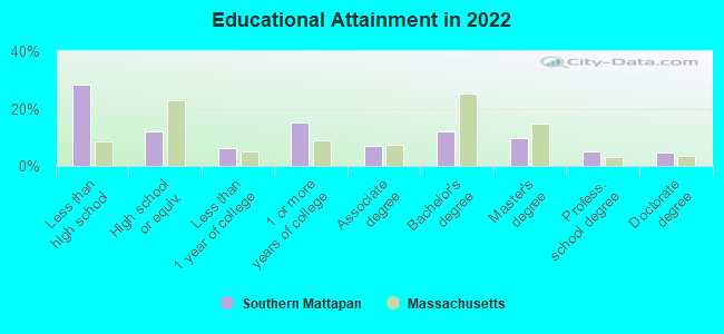
Education in this neighborhood (subdivision or community):
- Percentage of people 3 years and older in K-12 schools:
Southern Mattapan: 30.8% Massachusetts: 14.7%
- Percentage of people 3 years and older in undergraduate colleges:
Southern Mattapan: 9.2% Massachusetts: 5.9%
- Percentage of people 3 years and older in grad. or professional schools:
Southern Mattapan: 4.1% Massachusetts: 2.2%
- Percentage of students K-12 enrolled in private schools:
Southern Mattapan: 45.4% Massachusetts: 11.0%
Percentage of population below poverty level:
| Southern Mattapan: | 16.8% |
| Massachusetts: | 10.4% |
Percentage of married-couple families with both working:
| Southern Mattapan: | 105.8% |
| Massachusetts: | 78.0% |
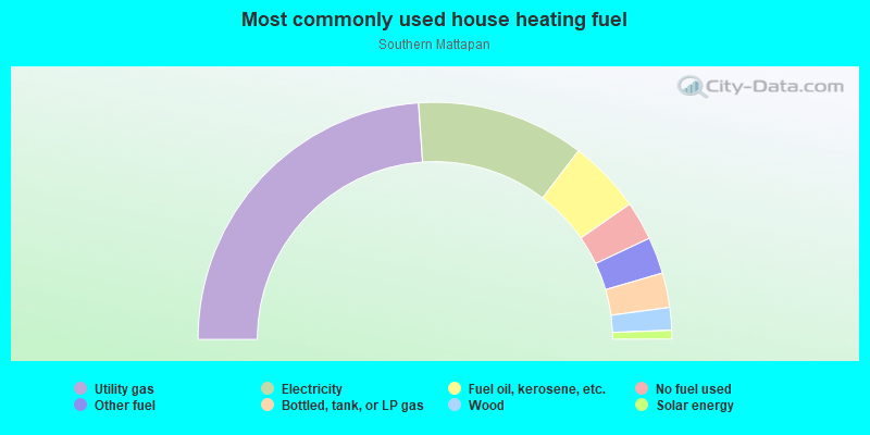
- 47.8%Utility gas
- 22.9%Electricity
- 10.0%Fuel oil, kerosene, etc.
- 5.3%No fuel used
- 5.0%Other fuel
- 4.7%Bottled, tank, or LP gas
- 3.1%Wood
- 1.2%Solar energy
Other features:
Neponset Riv
Length: 0.13 miles
Directions: E-W, SE-NW
Directions: E-W, SE-NW
Highways in this neighborhood:
Blue Hill Ave (State Hwy 28)
Length: 0.75 miles
Direction: N-S
Direction: N-S
State Hwy 203 (Morton St)
Length: 0.27 miles
Directions: E-W, SE-NW
Address range: 1033 to 1060
Directions: E-W, SE-NW
Address range: 1033 to 1060
Roads and streets:
River St
Length: 1.43 miles
Directions: E-W, SW-NE
Address range: 166 to 618
Directions: E-W, SW-NE
Address range: 166 to 618
Cummins Hwy
Length: 0.92 miles
Directions: E-W, SE-NW
Address range: 627 to 964
Directions: E-W, SE-NW
Address range: 627 to 964
Alabama St
Length: 0.77 miles
Directions: E-W, N-S, SW-NE
Address range: 1 to 275
Directions: E-W, N-S, SW-NE
Address range: 1 to 275
W Selden St
Length: 0.71 miles
Direction: SW-NE
Address range: 1 to 299
Direction: SW-NE
Address range: 1 to 299
Messinger St
Length: 0.69 miles
Directions: E-W, SE-NW, SW-NE
Address range: 1 to 299
Directions: E-W, SE-NW, SW-NE
Address range: 1 to 299
Colorado St
Length: 0.68 miles
Direction: SW-NE
Address range: 15 to 301
Direction: SW-NE
Address range: 15 to 301
Itasca St
Length: 0.63 miles
Directions: E-W, N-S, SW-NE
Address range: 30 to 299
Directions: E-W, N-S, SW-NE
Address range: 30 to 299
Woodbole Ave
Length: 0.54 miles
Directions: E-W, N-S, SE-NW, SW-NE
Address range: 1 to 199
Directions: E-W, N-S, SE-NW, SW-NE
Address range: 1 to 199
Canaan St
Length: 0.53 miles
Directions: N-S, SE-NW, SW-NE
Address range: 1 to 199
Directions: N-S, SE-NW, SW-NE
Address range: 1 to 199
Standard St
Length: 0.47 miles
Directions: N-S, SE-NW, SW-NE
Address range: 1 to 199
Directions: N-S, SE-NW, SW-NE
Address range: 1 to 199
Hebron St
Length: 0.44 miles
Directions: N-S, SE-NW, SW-NE
Address range: 1 to 164
Directions: N-S, SE-NW, SW-NE
Address range: 1 to 164
Currier St
Length: 0.42 miles
Directions: E-W, N-S, SE-NW, SW-NE
Address range: 1 to 65
Directions: E-W, N-S, SE-NW, SW-NE
Address range: 1 to 65
Savannah Ave
Length: 0.42 miles
Direction: SW-NE
Address range: 1 to 299
Direction: SW-NE
Address range: 1 to 299
Delhi St
Length: 0.38 miles
Directions: E-W, SW-NE
Address range: 1 to 251
Directions: E-W, SW-NE
Address range: 1 to 251
Woodhaven St
Length: 0.38 miles
Directions: E-W, SW-NE
Address range: 1 to 199
Directions: E-W, SW-NE
Address range: 1 to 199
Gladeside Ave
Length: 0.37 miles
Directions: N-S, SW-NE
Address range: 1 to 122
Directions: N-S, SW-NE
Address range: 1 to 122
Kennebec St
Length: 0.37 miles
Direction: SW-NE
Address range: 1 to 180
Direction: SW-NE
Address range: 1 to 180
Almont St
Length: 0.35 miles
Directions: N-S, SE-NW
Address range: 61 to 299
Directions: N-S, SE-NW
Address range: 61 to 299
Rockdale St
Length: 0.34 miles
Direction: SW-NE
Address range: 1 to 199
Direction: SW-NE
Address range: 1 to 199
Babson St
Length: 0.34 miles
Directions: E-W, N-S, SW-NE
Address range: 66 to 184
Directions: E-W, N-S, SW-NE
Address range: 66 to 184
Hollingsworth St
Length: 0.33 miles
Direction: SW-NE
Address range: 1 to 123
Direction: SW-NE
Address range: 1 to 123
Lorna Rd
Length: 0.33 miles
Direction: SW-NE
Address range: 12 to 149
Direction: SW-NE
Address range: 12 to 149
Monterey Ave
Length: 0.33 miles
Directions: E-W, SE-NW
Address range: 1 to 78
Directions: E-W, SE-NW
Address range: 1 to 78
Woodruff Way
Length: 0.32 miles
Directions: E-W, N-S, SE-NW
Address range: 1 to 99
Directions: E-W, N-S, SE-NW
Address range: 1 to 99
Croydon St
Length: 0.32 miles
Directions: E-W, N-S, SE-NW
Address range: 1 to 99
Directions: E-W, N-S, SE-NW
Address range: 1 to 99
Livermore St
Length: 0.31 miles
Direction: SW-NE
Address range: 1 to 104
Direction: SW-NE
Address range: 1 to 104
Regis Rd
Length: 0.28 miles
Directions: E-W, SW-NE
Address range: 1 to 99
Directions: E-W, SW-NE
Address range: 1 to 99
Ridgeview Ave
Length: 0.28 miles
Directions: N-S, SE-NW, SW-NE
Address range: 1 to 99
Directions: N-S, SE-NW, SW-NE
Address range: 1 to 99
Fremont St
Length: 0.27 miles
Direction: SE-NW
Address range: 1 to 99
Direction: SE-NW
Address range: 1 to 99
Edgewater Dr
Length: 0.27 miles
Direction: SW-NE
Address range: 1 to 91
Direction: SW-NE
Address range: 1 to 91
Favre St
Length: 0.27 miles
Direction: SW-NE
Address range: 1 to 99
Direction: SW-NE
Address range: 1 to 99
Fairlawn Apartment
Length: 0.27 miles
Directions: E-W, N-S, SE-NW, SW-NE
Directions: E-W, N-S, SE-NW, SW-NE
Orlando St
Length: 0.26 miles
Direction: SW-NE
Address range: 1 to 199
Direction: SW-NE
Address range: 1 to 199
Faunce Rd
Length: 0.25 miles
Directions: E-W, N-S, SE-NW, SW-NE
Address range: 1 to 99
Directions: E-W, N-S, SE-NW, SW-NE
Address range: 1 to 99
Meadowbank Ave
Length: 0.24 miles
Directions: E-W, N-S, SW-NE
Address range: 1 to 99
Directions: E-W, N-S, SW-NE
Address range: 1 to 99
Brockton St
Length: 0.23 miles
Direction: SW-NE
Address range: 1 to 99
Direction: SW-NE
Address range: 1 to 99
Rexford St
Length: 0.23 miles
Directions: E-W, SW-NE
Address range: 1 to 99
Directions: E-W, SW-NE
Address range: 1 to 99
Riverdale Rd
Length: 0.23 miles
Direction: E-W
Address range: 18 to 98
Direction: E-W
Address range: 18 to 98
Richmere Rd
Length: 0.22 miles
Directions: N-S, SW-NE
Address range: 1 to 99
Directions: N-S, SW-NE
Address range: 1 to 99
Stonecrest Rd
Length: 0.22 miles
Directions: E-W, SE-NW
Directions: E-W, SE-NW
Hallowell St
Length: 0.22 miles
Direction: SW-NE
Address range: 1 to 99
Direction: SW-NE
Address range: 1 to 99
Woodgate St
Length: 0.21 miles
Directions: E-W, SW-NE
Address range: 1 to 99
Directions: E-W, SW-NE
Address range: 1 to 99
Violet St
Length: 0.20 miles
Directions: N-S, SE-NW, SW-NE
Address range: 1 to 99
Directions: N-S, SE-NW, SW-NE
Address range: 1 to 99
Mamelon Cir
Length: 0.19 miles
Directions: E-W, N-S, SE-NW, SW-NE
Address range: 1 to 99
Directions: E-W, N-S, SE-NW, SW-NE
Address range: 1 to 99
Harmon St
Length: 0.19 miles
Directions: N-S, SW-NE
Address range: 1 to 99
Directions: N-S, SW-NE
Address range: 1 to 99
Cookson Ter
Length: 0.19 miles
Directions: E-W, SE-NW
Address range: 1 to 62
Directions: E-W, SE-NW
Address range: 1 to 62
Corman Rd
Length: 0.18 miles
Directions: E-W, N-S, SE-NW, SW-NE
Address range: 1 to 99
Directions: E-W, N-S, SE-NW, SW-NE
Address range: 1 to 99
Dania St
Length: 0.18 miles
Directions: E-W, N-S, SE-NW, SW-NE
Address range: 1 to 99
Directions: E-W, N-S, SE-NW, SW-NE
Address range: 1 to 99
Crossman St
Length: 0.17 miles
Directions: E-W, SE-NW
Address range: 1 to 99
Directions: E-W, SE-NW
Address range: 1 to 99
Doone Ave
Length: 0.16 miles
Direction: SE-NW
Address range: 1 to 40
Direction: SE-NW
Address range: 1 to 40
Newcroft Cir
Length: 0.16 miles
Directions: E-W, N-S, SE-NW, SW-NE
Address range: 1 to 99
Directions: E-W, N-S, SE-NW, SW-NE
Address range: 1 to 99
Glenhill Rd
Length: 0.15 miles
Direction: SW-NE
Address range: 1 to 99
Direction: SW-NE
Address range: 1 to 99
Freeland St
Length: 0.15 miles
Directions: N-S, SE-NW, SW-NE
Address range: 1 to 99
Directions: N-S, SE-NW, SW-NE
Address range: 1 to 99
Stow Rd
Length: 0.15 miles
Direction: SW-NE
Address range: 1 to 99
Direction: SW-NE
Address range: 1 to 99
Bluefield Ter
Length: 0.14 miles
Direction: SE-NW
Address range: 1 to 99
Direction: SE-NW
Address range: 1 to 99
Greenfield Rd
Length: 0.14 miles
Direction: SE-NW
Address range: 2 to 111
Direction: SE-NW
Address range: 2 to 111
Southmere Rd
Length: 0.14 miles
Directions: E-W, SE-NW
Address range: 1 to 99
Directions: E-W, SE-NW
Address range: 1 to 99
Halborn St
Length: 0.14 miles
Direction: SE-NW
Address range: 1 to 99
Direction: SE-NW
Address range: 1 to 99
Lena Ter
Length: 0.13 miles
Directions: E-W, SE-NW
Address range: 1 to 99
Directions: E-W, SE-NW
Address range: 1 to 99
Rich St
Length: 0.13 miles
Direction: SE-NW
Address range: 1 to 99
Direction: SE-NW
Address range: 1 to 99
Woodale Ave
Length: 0.13 miles
Direction: SE-NW
Address range: 1 to 99
Direction: SE-NW
Address range: 1 to 99
Mary Moore Beatty Cir
Length: 0.13 miles
Direction: SE-NW
Address range: 2 to 98
Direction: SE-NW
Address range: 2 to 98
Newcastle St
Length: 0.12 miles
Direction: SE-NW
Address range: 2 to 99
Direction: SE-NW
Address range: 2 to 99
Briercliff Ter
Length: 0.12 miles
Direction: E-W
Address range: 1 to 99
Direction: E-W
Address range: 1 to 99
Linvale Ter
Length: 0.12 miles
Directions: E-W, SW-NE
Address range: 1 to 99
Directions: E-W, SW-NE
Address range: 1 to 99
Malta St
Length: 0.11 miles
Direction: SE-NW
Address range: 1 to 99
Direction: SE-NW
Address range: 1 to 99
Arborcrest Ter
Length: 0.11 miles
Directions: E-W, SE-NW
Address range: 1 to 99
Directions: E-W, SE-NW
Address range: 1 to 99
Fairway St
Length: 0.11 miles
Directions: E-W, SW-NE
Address range: 1 to 99
Directions: E-W, SW-NE
Address range: 1 to 99
Ledgebrook Rd
Length: 0.11 miles
Direction: N-S
Address range: 1 to 99
Direction: N-S
Address range: 1 to 99
Prairie St
Length: 0.11 miles
Directions: E-W, SW-NE
Address range: 1 to 99
Directions: E-W, SW-NE
Address range: 1 to 99
Violante St
Length: 0.11 miles
Directions: N-S, SE-NW, SW-NE
Address range: 1 to 99
Directions: N-S, SE-NW, SW-NE
Address range: 1 to 99
Tiverton Rd
Length: 0.11 miles
Direction: SE-NW
Address range: 1 to 99
Direction: SE-NW
Address range: 1 to 99
Topalian St
Length: 0.10 miles
Direction: SE-NW
Address range: 1 to 99
Direction: SE-NW
Address range: 1 to 99
Ruxton Rd
Length: 0.10 miles
Direction: SE-NW
Address range: 1 to 99
Direction: SE-NW
Address range: 1 to 99
Cragmere Ter
Length: 0.10 miles
Directions: E-W, SE-NW
Address range: 1 to 99
Directions: E-W, SE-NW
Address range: 1 to 99
Culbert St
Length: 0.10 miles
Direction: SE-NW
Address range: 1 to 99
Direction: SE-NW
Address range: 1 to 99
Banfield Ave
Length: 0.10 miles
Direction: SW-NE
Address range: 1 to 99
Direction: SW-NE
Address range: 1 to 99
Donwood Ter
Length: 0.10 miles
Direction: SE-NW
Address range: 1 to 99
Direction: SE-NW
Address range: 1 to 99
Tesla St
Length: 0.10 miles
Direction: SE-NW
Address range: 1 to 99
Direction: SE-NW
Address range: 1 to 99
Wabash St
Length: 0.10 miles
Directions: N-S, SW-NE
Address range: 1 to 37
Directions: N-S, SW-NE
Address range: 1 to 37
Bismarck St
Length: 0.09 miles
Direction: SW-NE
Address range: 1 to 99
Direction: SW-NE
Address range: 1 to 99
Leahaven Rd
Length: 0.09 miles
Direction: N-S
Address range: 1 to 99
Direction: N-S
Address range: 1 to 99
Merola Park
Length: 0.09 miles
Direction: SW-NE
Address range: 1 to 99
Direction: SW-NE
Address range: 1 to 99
Duxbury Rd
Length: 0.09 miles
Direction: N-S
Address range: 1 to 99
Direction: N-S
Address range: 1 to 99
French St
Length: 0.09 miles
Direction: SE-NW
Address range: 1 to 99
Direction: SE-NW
Address range: 1 to 99
Burmah St
Length: 0.08 miles
Direction: SE-NW
Address range: 1 to 99
Direction: SE-NW
Address range: 1 to 99
Desmond Rd
Length: 0.08 miles
Directions: N-S, SE-NW
Address range: 1 to 99
Directions: N-S, SE-NW
Address range: 1 to 99
Constitution Rd
Length: 0.07 miles
Direction: SE-NW
Address range: 1 to 99
Direction: SE-NW
Address range: 1 to 99
Owen St
Length: 0.07 miles
Direction: SW-NE
Address range: 1 to 99
Direction: SW-NE
Address range: 1 to 99
Maryknoll St
Length: 0.07 miles
Direction: SW-NE
Address range: 18 to 25
Direction: SW-NE
Address range: 18 to 25
Riverbank Pl
Length: 0.07 miles
Direction: SE-NW
Address range: 1 to 99
Direction: SE-NW
Address range: 1 to 99
Elene St
Length: 0.07 miles
Direction: SE-NW
Address range: 1 to 99
Direction: SE-NW
Address range: 1 to 99
Rockway St
Length: 0.07 miles
Direction: SE-NW
Address range: 1 to 99
Direction: SE-NW
Address range: 1 to 99
Marcy Rd
Length: 0.06 miles
Directions: N-S, SW-NE
Address range: 1 to 99
Directions: N-S, SW-NE
Address range: 1 to 99
Rugby Rd
Length: 0.06 miles
Direction: SW-NE
Address range: 1 to 48
Direction: SW-NE
Address range: 1 to 48
Gillespies Ln
Length: 0.06 miles
Direction: SE-NW
Direction: SE-NW
Viking Ter
Length: 0.05 miles
Direction: SE-NW
Address range: 1 to 99
Direction: SE-NW
Address range: 1 to 99
Verndale St
Length: 0.05 miles
Direction: SE-NW
Address range: 1 to 99
Direction: SE-NW
Address range: 1 to 99
Maryknoll Ter
Length: 0.05 miles
Direction: SE-NW
Address range: 1 to 99
Direction: SE-NW
Address range: 1 to 99
Fairlawn Ave
Length: 0.05 miles
Direction: SW-NE
Address range: 1 to 99
Direction: SW-NE
Address range: 1 to 99
Avander Ct
Length: 0.05 miles
Directions: N-S, SW-NE
Address range: 1 to 99
Directions: N-S, SW-NE
Address range: 1 to 99
Delnore Pl
Length: 0.04 miles
Direction: SW-NE
Address range: 1 to 99
Direction: SW-NE
Address range: 1 to 99
Ridlon Rd
Length: 0.04 miles
Direction: SW-NE
Address range: 71 to 99
Direction: SW-NE
Address range: 71 to 99
Oakland Ct
Length: 0.04 miles
Directions: E-W, N-S
Directions: E-W, N-S
Henrici St
Length: 0.04 miles
Direction: SE-NW
Address range: 1 to 99
Direction: SE-NW
Address range: 1 to 99
Youngs Rd
Length: 0.04 miles
Direction: SE-NW
Address range: 1 to 6
Direction: SE-NW
Address range: 1 to 6
Gladeside Ter
Length: 0.04 miles
Direction: E-W
Address range: 1 to 99
Direction: E-W
Address range: 1 to 99
Hopkins Pl
Length: 0.04 miles
Directions: SE-NW, SW-NE
Address range: 1 to 99
Directions: SE-NW, SW-NE
Address range: 1 to 99
Ives St
Length: 0.04 miles
Direction: SE-NW
Direction: SE-NW
Eskridge St
Length: 0.04 miles
Direction: E-W
Address range: 12 to 99
Direction: E-W
Address range: 12 to 99
Jamestown Ter
Length: 0.04 miles
Direction: SE-NW
Address range: 1 to 99
Direction: SE-NW
Address range: 1 to 99
Rector Rd
Length: 0.04 miles
Direction: SE-NW
Address range: 45 to 99
Direction: SE-NW
Address range: 45 to 99
Chester Park
Length: 0.03 miles
Direction: SW-NE
Address range: 1 to 99
Direction: SW-NE
Address range: 1 to 99
Central Ave
Length: 0.03 miles
Direction: N-S
Address range: 8 to 10
Direction: N-S
Address range: 8 to 10
N127
Length: 0.03 miles
Directions: N-S, SE-NW
Directions: N-S, SE-NW
Oak Hill Ave
Length: 0.03 miles
Direction: SE-NW
Address range: 1 to 99
Direction: SE-NW
Address range: 1 to 99
Dania Ter
Length: 0.03 miles
Direction: SE-NW
Address range: 1 to 99
Direction: SE-NW
Address range: 1 to 99
Golding St
Length: 0.02 miles
Direction: E-W
Address range: 1 to 99
Direction: E-W
Address range: 1 to 99
Morton Villiage Dr
Length: 0.02 miles
Direction: N-S
Address range: 1 to 99
Direction: N-S
Address range: 1 to 99
Railroad features:
Mbta Commuter Rail
Length: 0.75 miles
Direction: SW-NE
Direction: SW-NE
Mass transit rail lines:
Mbta Red Line RR (Ashmont-Mattapan Trolley)
Length: 0.28 miles
Direction: E-W
Direction: E-W
Other features:
Neponset Riv
Length: 0.13 miles
Directions: E-W, SE-NW
Directions: E-W, SE-NW