Southtown neighborhood in San Antonio, Texas (TX), 78204, 78210 detailed profile
Settings
X


Business Search - 14 Million verified businesses
Area: 2.183 square miles
Population: 17,584
Population density:
| Southtown: | 8,055 people per square mile |
| San Antonio: | 3,614 people per square mile |

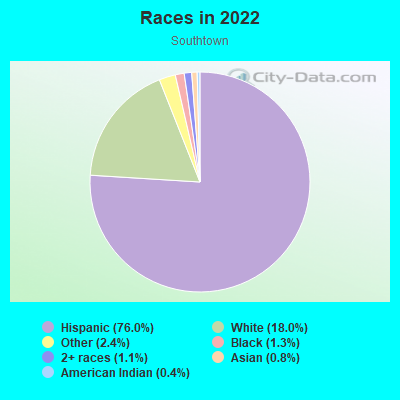
- 14,18476.0%Hispanic or Latino
- 3,35918.0%White
- 4472.4%Some other race
- 2491.3%Black
- 1991.1%Two or more races
- 1480.8%Asian
- 790.4%American Indian
Distribution of median household income
![Distribution of median household income]()
- 635Less than $10,000
- 888$10,000 to $19,999
- 986$20,000 to $29,999
- 1,580$30,000 to $39,999
- 736$40,000 to $49,999
- 410$50,000 to $59,999
- 1,201$60,000 to $74,999
- 472$75,000 to $99,999
- 860$100,000 to $124,999
- 193$125,000 to $149,999
- 804$150,000 to $199,999
- 727$200,000 or more

Distribution of owner-occupied house/condo value
![Distribution of owner-occupied house/condo value]()
- 1,106Less than $50,000
- 2,513$50,000 to $99,999
- 981$100,000 to $149,999
- 557$150,000 to $199,999
- 419$200,000 to $249,999
- 726$250,000 to $299,999
- 280$300,000 to $399,999
- 400$400,000 to $499,999
- 706$500,000 to $749,999

Distribution of rent paid by renters
![Distribution of rent paid by renters]()
- 90Less than $100
- 218$100 to $199
- 410$200 to $299
- 210$300 to $399
- 292$400 to $499
- 1,119$500 to $599
- 884$600 to $699
- 445$700 to $799
- 261$800 to $899
- 228$900 to $999
- 835$1,000 to $1,249
- 782$1,250 to $1,499
- 1,657$1,500 to $1,999
- 471$2,000 or more

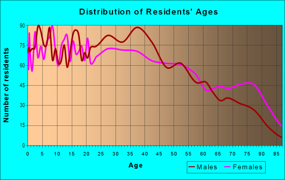
| Males: | 10,194 |
| Females: | 7,390 |
Males:
| This neighborhood: | 30.9 years |
| Whole city: | 33.3 years |
| This neighborhood: | 39.3 years |
| Whole city: | 35.2 years |
Average household size:
| Southtown: | 4.7 people |
| San Antonio: | 2.6 people |
Percentage of family households:
| Southtown: | 35.3% |
| San Antonio: | 45.4% |
| Here: | 26.0% |
| San Antonio: | 38.6% |
Percentage of married-couple families with children (among all households):
| Southtown: | 23.9% |
| San Antonio: | 22.7% |
Percentage of single-mother households (among all households):
| Southtown: | 21.9% |
| San Antonio: | 11.2% |
Percentage of never married males 15 years old and over:
Percentage of never married females 15 years old and over:
| Southtown: | 29.0% |
| San Antonio: | 21.9% |
Percentage of never married females 15 years old and over:
| Southtown: | 18.1% |
| city: | 18.9% |
Percentage of people that speak English not well or not at all:
| Southtown: | 7.6% |
| San Antonio: | 6.4% |
Percentage of people born in this state:
Percentage of people born in another U.S. state:
Percentage of native residents but born outside the U.S.:
Percentage of foreign born residents:
| Here: | 70.9% |
| San Antonio: | 64.4% |
Percentage of people born in another U.S. state:
| Southtown: | 11.6% |
| San Antonio: | 18.9% |
Percentage of native residents but born outside the U.S.:
| Here: | 2.1% |
| city: | 2.3% |
Percentage of foreign born residents:
| Here: | 15.4% |
| San Antonio: | 14.4% |
Owner-occupied
Renter-occupied

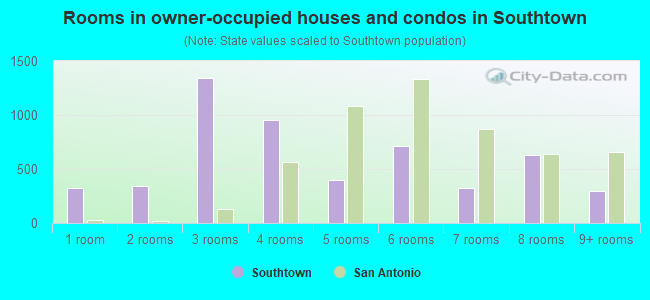
- Rooms in owner-occupied houses and condos in Southtown
- 3271 room
- 3442 rooms
- 1,3393 rooms
- 9554 rooms
- 4005 rooms
- 7106 rooms
- 3207 rooms
- 6308 rooms
- 2969+ rooms
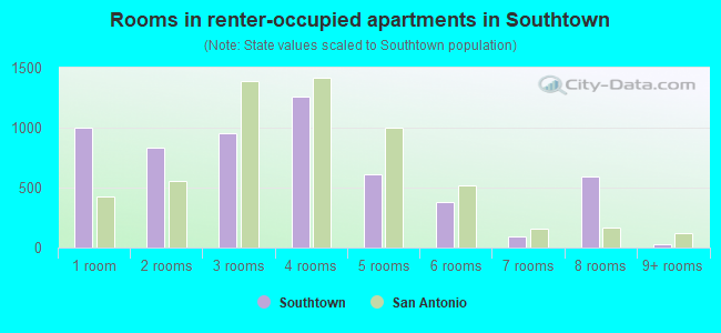
- Rooms in renter-occupied apartments in Southtown
- 9981 room
- 8292 rooms
- 9543 rooms
- 1,2634 rooms
- 6085 rooms
- 3826 rooms
- 907 rooms
- 5888 rooms
- 289+ rooms
Owner-occupied
Renter-occupied
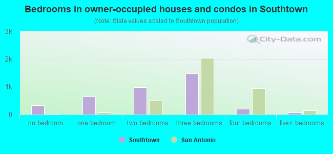
- Bedrooms in owner-occupied houses and condos in Southtown
- 327no bedroom
- 6531 bedroom
- 9852 bedrooms
- 1,4793 bedrooms
- 1954 bedrooms
- 725+ bedrooms
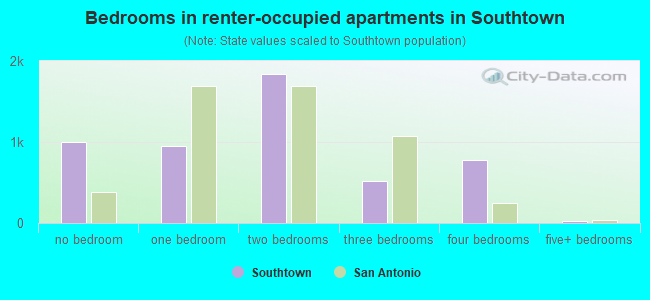
- Bedrooms in renter-occupied apartments in Southtown
- 998no bedroom
- 9561 bedroom
- 1,8432 bedrooms
- 5213 bedrooms
- 7814 bedrooms
- 285+ bedrooms
Average number of cars or other vehicles available in houses/condos:
Average number of cars or other vehicles available in apartments:
| This neighborhood: | |
| San Antonio: |
Average number of cars or other vehicles available in apartments:
| Here: | 1.4 |
| city: | 1.3 |
Percentage of units with a mortgage:
| Southtown: | 28.7% |
| San Antonio: | 55.6% |
Average estimated value of detached houses in 2022 (60.9% of all units):
| Southtown: | $178,194 |
| San Antonio: | $257,450 |
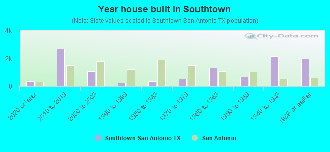
- Year house built in Southtown
- 3602020 or later
- 2,7282010 to 2019
- 1,0502000 to 2009
- 2561990 to 1999
- 3761980 to 1989
- 5531970 to 1979
- 1,3111960 to 1969
- 7041950 to 1959
- 2,1631940 to 1949
- 1,9811939 or earlier
City-data.com crime index for city in 2020 (higher means more crime):
| City: | 398.9 |
| U.S. average: | 219.5 |
Travel time to work (commute)
![Travel time to work (commute)]()
- 257Less than 5 minutes
- 5195 to 9 minutes
- 1,26610 to 14 minutes
- 1,11915 to 19 minutes
- 91220 to 24 minutes
- 39125 to 29 minutes
- 70530 to 34 minutes
- 29435 to 39 minutes
- 15640 to 44 minutes
- 86645 to 59 minutes
- 25460 to 89 minutes
- 22990 or more minutes

Means of transportation to work
![Means of transportation to work]()
- 73.3%6,330Drove a car alone
- 13.0%1,124Carpooled
- 5.7%491Bus
- 1.2%102Bicycle
- 6.4%554Walked
- 2.8%242Other means
- 6.8%588Worked at home

Time leaving home to go to work
![Time leaving home to go to work]()
- 25412:00 a.m. to 4:59 a.m.
- 635:00 a.m. to 5:29 a.m.
- 1715:30 a.m. to 5:59 a.m.
- 4556:00 a.m. to 6:29 a.m.
- 1,1566:30 a.m. to 6:59 a.m.
- 1,3597:00 a.m. to 7:29 a.m.
- 9627:30 a.m. to 7:59 a.m.
- 3928:00 a.m. to 8:29 a.m.
- 4238:30 a.m. to 8:59 a.m.
- 2219:00 a.m. to 9:59 a.m.
- 27710:00 a.m. to 10:59 a.m.
- 6611:00 a.m. to 11:59 a.m.
- 22212:00 p.m. to 3:59 p.m.
- 3624:00 p.m. to 11:59 p.m.

Occupations of males:
- Percentage of males in management occupations (except farmers):
Here: 24.4% city: 9.0%
- Percentage of males in business and financial operations occupations:
Here: 4.4% city: 4.3%
- Percentage of males in computer and mathematical occupations:
Here: 3.9% city: 4.5%
- Percentage of males in architecture and engineering occupations:
Here: 3.2% city: 2.1%
- Percentage of males in legal occupations:
Here: 2.3% city: 1.0%
- Percentage of males in arts, design, entertainment, sports, and media occupations:
Here: 6.2% city: 1.6%
- Percentage of males in service occupations:
Here: 12.7% city: 17.8%
- Percentage of males in sales and office occupations:
Here: 11.8% city: 16.0%
- Percentage of males in construction, extraction, and maintenance occupations:
Here: 13.6% city: 12.4%
- Percentage of males in production occupations:
Here: 2.2% city: 5.4%
- Percentage of males in transportation occupations:
Here: 4.6% city: 6.2%
- Percentage of males in material moving occupations:
Here: 8.8% city: 5.3%
Occupations of females:
- Percentage of females in management occupations (except farmers):
Here: 12.3% city: 8.7%
- Percentage of females in business and financial operations occupations:
Here: 2.2% city: 5.6%
- Percentage of females in computer and mathematical occupations:
Here: 4.8% city: 1.6%
- Percentage of females in legal occupations:
Here: 1.6% city: 0.9%
- Percentage of females in education, training, and library occupations:
Here: 8.7% city: 8.8%
- Percentage of females in healthcare practitioners and technical occupations:
Here: 11.3% city: 8.5%
- Percentage of females in service occupations:
Here: 12.1% city: 22.8%
- Percentage of females in sales and office occupations:
Here: 36.7% city: 31.9%
- Percentage of females in production occupations:
Here: 8.2% city: 2.3%
- Percentage of females in transportation occupations:
Here: 1.1% city: 1.1%
- Percentage of females in material moving occupations:
Here: 2.6% city: 1.7%
Percentage of people 16-64 in Armed Forces:
| Southtown: | 0.4% |
| San Antonio: | 1.6% |
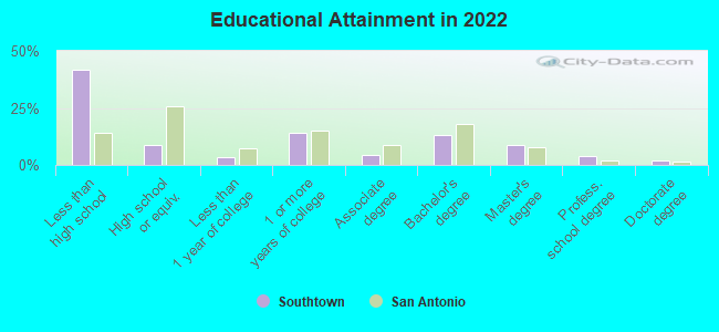
Education in this neighborhood (subdivision or community):
- Percentage of people 3 years and older in K-12 schools:
Southtown: 27.6% San Antonio: 18.3%
- Percentage of people 3 years and older in undergraduate colleges:
Southtown: 5.7% San Antonio: 6.1%
- Percentage of people 3 years and older in grad. or professional schools:
Southtown: 5.2% San Antonio: 1.4%
- Percentage of students K-12 enrolled in private schools:
Southtown: 27.5% San Antonio: 9.7%
Percentage of population below poverty level:
| Southtown: | 23.4% |
| San Antonio: | 18.7% |
Percentage of married-couple families with both working:
| Southtown: | 84.1% |
| San Antonio: | 59.5% |
- 61.5%Electricity
- 28.1%Utility gas
- 4.2%Bottled, tank, or LP gas
- 3.8%Solar energy
- 2.4%No fuel used
Limited-access highways (interstate or state) in this neighborhood:
I- 35 (I- 10, US Hwy 87, S Pan Am Expy, US Hwy 81)
Length: 1.73 miles
Directions: E-W, N-S, SW-NE
Directions: E-W, N-S, SW-NE
Highways in this neighborhood:
State Spur 536 (S Alamo St)
Length: 1.54 miles
Directions: E-W, N-S, SE-NW, SW-NE
Address range: 600 to 2251
Directions: E-W, N-S, SE-NW, SW-NE
Address range: 600 to 2251
Steves Ave (State Spur 536)
Length: 0.08 miles
Directions: E-W, SE-NW
Address range: 400 to 421
Directions: E-W, SE-NW
Address range: 400 to 421
Roads and streets:
S Flores St
Length: 1.75 miles
Directions: N-S, SW-NE
Address range: 500 to 2898
Directions: N-S, SW-NE
Address range: 500 to 2898
S Presa St
Length: 1.19 miles
Directions: N-S, SE-NW
Address range: 501 to 1899
Directions: N-S, SE-NW
Address range: 501 to 1899
S Saint Marys St (S St Mary's)
Length: 1.10 miles
Direction: N-S
Address range: 701 to 1999
Direction: N-S
Address range: 701 to 1999
Nogalitos St
Length: 1.02 miles
Directions: E-W, SW-NE
Address range: 100 to 1266
Directions: E-W, SW-NE
Address range: 100 to 1266
Probandt St
Length: 1.01 miles
Directions: N-S, SE-NW, SW-NE
Address range: 1 to 1063
Directions: N-S, SE-NW, SW-NE
Address range: 1 to 1063
E Guenther St
Length: 0.77 miles
Direction: SE-NW
Address range: 100 to 899
Direction: SE-NW
Address range: 100 to 899
S Main Ave
Length: 0.67 miles
Directions: N-S, SW-NE
Address range: 516 to 1399
Directions: N-S, SW-NE
Address range: 516 to 1399
Labor St
Length: 0.64 miles
Direction: N-S
Address range: 200 to 999
Direction: N-S
Address range: 200 to 999
Lone Star Blvd
Length: 0.64 miles
Direction: E-W
Address range: 100 to 499
Direction: E-W
Address range: 100 to 499
Bank St
Length: 0.63 miles
Direction: E-W
Address range: 100 to 399
Direction: E-W
Address range: 100 to 399
Helena St
Length: 0.61 miles
Direction: E-W
Address range: 100 to 599
Direction: E-W
Address range: 100 to 599
Cedar St
Length: 0.60 miles
Directions: N-S, SE-NW, SW-NE
Address range: 100 to 699
Directions: N-S, SE-NW, SW-NE
Address range: 100 to 699
Blue Star
Length: 0.59 miles
Directions: E-W, N-S, SE-NW
Address range: 100 to 599
Directions: E-W, N-S, SE-NW
Address range: 100 to 599
St Francis Ave
Length: 0.58 miles
Directions: E-W, SE-NW
Address range: 100 to 399
Directions: E-W, SE-NW
Address range: 100 to 399
King William St
Length: 0.56 miles
Direction: SW-NE
Address range: 100 to 599
Direction: SW-NE
Address range: 100 to 599
Devine St
Length: 0.55 miles
Directions: E-W, SE-NW
Address range: 100 to 699
Directions: E-W, SE-NW
Address range: 100 to 699
Mission St
Length: 0.54 miles
Directions: N-S, SE-NW
Address range: 100 to 699
Directions: N-S, SE-NW
Address range: 100 to 699
Leigh St
Length: 0.54 miles
Directions: E-W, SE-NW
Address range: 100 to 699
Directions: E-W, SE-NW
Address range: 100 to 699
Furnish Ave
Length: 0.51 miles
Directions: E-W, SE-NW
Address range: 100 to 483
Directions: E-W, SE-NW
Address range: 100 to 483
Halstead St
Length: 0.51 miles
Directions: N-S, SE-NW, SW-NE
Address range: 100 to 1099
Directions: N-S, SE-NW, SW-NE
Address range: 100 to 1099
Madison St
Length: 0.51 miles
Direction: SW-NE
Address range: 100 to 599
Direction: SW-NE
Address range: 100 to 599
Wickes St
Length: 0.50 miles
Directions: N-S, SE-NW
Address range: 100 to 599
Directions: N-S, SE-NW
Address range: 100 to 599
Sadie St
Length: 0.49 miles
Directions: E-W, SE-NW
Address range: 100 to 699
Directions: E-W, SE-NW
Address range: 100 to 699
Adams St
Length: 0.49 miles
Directions: N-S, SE-NW
Address range: 100 to 599
Directions: N-S, SE-NW
Address range: 100 to 599
Simon St
Length: 0.48 miles
Direction: E-W
Address range: 100 to 399
Direction: E-W
Address range: 100 to 399
E Lambert St
Length: 0.47 miles
Direction: E-W
Address range: 100 to 399
Direction: E-W
Address range: 100 to 399
Florida St
Length: 0.45 miles
Directions: E-W, SW-NE
Address range: 100 to 419
Directions: E-W, SW-NE
Address range: 100 to 419
W Cevallos St
Length: 0.45 miles
Direction: E-W
Address range: 100 to 599
Direction: E-W
Address range: 100 to 599
Oelkers St
Length: 0.45 miles
Direction: E-W
Address range: 100 to 299
Direction: E-W
Address range: 100 to 299
Pruitt Ave
Length: 0.44 miles
Direction: E-W
Address range: 100 to 599
Direction: E-W
Address range: 100 to 599
Clay St
Length: 0.44 miles
Direction: E-W
Address range: 100 to 499
Direction: E-W
Address range: 100 to 499
E Durango Blvd
Length: 0.44 miles
Directions: E-W, SE-NW
Address range: 100 to 799
Directions: E-W, SE-NW
Address range: 100 to 799
E Baylor St
Length: 0.42 miles
Direction: E-W
Address range: 100 to 421
Direction: E-W
Address range: 100 to 421
W Baylor St
Length: 0.41 miles
Direction: E-W
Address range: 100 to 588
Direction: E-W
Address range: 100 to 588
E Cevallos St
Length: 0.41 miles
Direction: E-W
Address range: 100 to 499
Direction: E-W
Address range: 100 to 499
Cass Ave
Length: 0.41 miles
Directions: E-W, SE-NW
Address range: 101 to 599
Directions: E-W, SE-NW
Address range: 101 to 599
S Laredo St
Length: 0.39 miles
Directions: E-W, SW-NE
Address range: 1200 to 1501
Directions: E-W, SW-NE
Address range: 1200 to 1501
W Lachapelle
Length: 0.39 miles
Directions: E-W, SE-NW, SW-NE
Address range: 100 to 299
Directions: E-W, SE-NW, SW-NE
Address range: 100 to 299
Lavaca St
Length: 0.38 miles
Directions: E-W, SE-NW, SW-NE
Address range: 100 to 399
Directions: E-W, SE-NW, SW-NE
Address range: 100 to 399
Barbe St
Length: 0.38 miles
Direction: SW-NE
Address range: 100 to 699
Direction: SW-NE
Address range: 100 to 699
Forrest Ave
Length: 0.37 miles
Directions: E-W, SE-NW
Address range: 100 to 399
Directions: E-W, SE-NW
Address range: 100 to 399
Barrera St
Length: 0.37 miles
Directions: E-W, SE-NW
Address range: 100 to 499
Directions: E-W, SE-NW
Address range: 100 to 499
E Lachapelle (E Lachapelle St)
Length: 0.37 miles
Direction: E-W
Address range: 100 to 615
Direction: E-W
Address range: 100 to 615
Stieren St
Length: 0.36 miles
Directions: E-W, SW-NE
Address range: 100 to 599
Directions: E-W, SW-NE
Address range: 100 to 599
W Lubbock St
Length: 0.36 miles
Directions: E-W, SE-NW
Address range: 100 to 499
Directions: E-W, SE-NW
Address range: 100 to 499
Callaghan Ave
Length: 0.35 miles
Direction: SE-NW
Address range: 1 to 499
Direction: SE-NW
Address range: 1 to 499
E Fest St
Length: 0.33 miles
Direction: E-W
Address range: 100 to 499
Direction: E-W
Address range: 100 to 499
Keller St
Length: 0.33 miles
Direction: SE-NW
Address range: 100 to 499
Direction: SE-NW
Address range: 100 to 499
Dowdy St
Length: 0.33 miles
Direction: N-S
Address range: 100 to 599
Direction: N-S
Address range: 100 to 599
Pereida St
Length: 0.32 miles
Direction: E-W
Address range: 100 to 499
Direction: E-W
Address range: 100 to 499
E Lubbock St
Length: 0.30 miles
Direction: E-W
Address range: 100 to 523
Direction: E-W
Address range: 100 to 523
Refugio St
Length: 0.30 miles
Direction: SE-NW
Address range: 100 to 399
Direction: SE-NW
Address range: 100 to 399
Riddle St
Length: 0.30 miles
Direction: SW-NE
Address range: 1 to 599
Direction: SW-NE
Address range: 1 to 599
Eagleland Dr
Length: 0.30 miles
Direction: SW-NE
Address range: 100 to 599
Direction: SW-NE
Address range: 100 to 599
E Peden Aly
Length: 0.29 miles
Direction: E-W
Address range: 100 to 299
Direction: E-W
Address range: 100 to 299
W Peden Aly
Length: 0.29 miles
Directions: E-W, SE-NW
Address range: 100 to 399
Directions: E-W, SE-NW
Address range: 100 to 399
E Arsenal St
Length: 0.29 miles
Directions: E-W, SE-NW
Address range: 100 to 499
Directions: E-W, SE-NW
Address range: 100 to 499
Camargo St
Length: 0.29 miles
Directions: E-W, SE-NW
Address range: 100 to 399
Directions: E-W, SE-NW
Address range: 100 to 399
Carolina St
Length: 0.29 miles
Direction: E-W
Address range: 100 to 399
Direction: E-W
Address range: 100 to 399
Givens Ave
Length: 0.28 miles
Directions: E-W, N-S, SW-NE
Address range: 200 to 499
Directions: E-W, N-S, SW-NE
Address range: 200 to 499
Washington St
Length: 0.27 miles
Directions: E-W, SE-NW, SW-NE
Address range: 100 to 399
Directions: E-W, SE-NW, SW-NE
Address range: 100 to 399
Lotus Ave
Length: 0.27 miles
Direction: E-W
Address range: 105 to 299
Direction: E-W
Address range: 105 to 299
Delaware St
Length: 0.27 miles
Direction: E-W
Address range: 100 to 399
Direction: E-W
Address range: 100 to 399
Nathan St
Length: 0.27 miles
Directions: N-S, SW-NE
Address range: 100 to 599
Directions: N-S, SW-NE
Address range: 100 to 599
Carle Ave
Length: 0.27 miles
Direction: E-W
Address range: 115 to 299
Direction: E-W
Address range: 115 to 299
W Johnson St
Length: 0.25 miles
Directions: E-W, SE-NW
Address range: 100 to 499
Directions: E-W, SE-NW
Address range: 100 to 499
Midway Ave
Length: 0.25 miles
Direction: N-S
Address range: 101 to 499
Direction: N-S
Address range: 101 to 499
W Fest St
Length: 0.24 miles
Directions: E-W, N-S, SE-NW
Address range: 100 to 299
Directions: E-W, N-S, SE-NW
Address range: 100 to 299
Stribling St
Length: 0.23 miles
Directions: E-W, SE-NW
Address range: 100 to 199
Directions: E-W, SE-NW
Address range: 100 to 199
Rehman St
Length: 0.23 miles
Directions: E-W, N-S, SE-NW
Address range: 100 to 299
Directions: E-W, N-S, SE-NW
Address range: 100 to 299
Burbank St
Length: 0.23 miles
Directions: E-W, SE-NW
Address range: 100 to 199
Directions: E-W, SE-NW
Address range: 100 to 199
E Sheridan St
Length: 0.23 miles
Direction: SE-NW
Address range: 100 to 399
Direction: SE-NW
Address range: 100 to 399
W Zavalla St
Length: 0.22 miles
Direction: SE-NW
Address range: 100 to 289
Direction: SE-NW
Address range: 100 to 289
Mockert St
Length: 0.22 miles
Directions: N-S, SW-NE
Address range: 1 to 399
Directions: N-S, SW-NE
Address range: 1 to 399
Matagorda St
Length: 0.22 miles
Directions: E-W, SW-NE
Address range: 600 to 999
Directions: E-W, SW-NE
Address range: 600 to 999
Alvarez Pl
Length: 0.22 miles
Direction: E-W
Address range: 100 to 299
Direction: E-W
Address range: 100 to 299
Beauregard St
Length: 0.22 miles
Direction: SE-NW
Address range: 100 to 399
Direction: SE-NW
Address range: 100 to 399
W Sheridan St
Length: 0.22 miles
Direction: SE-NW
Address range: 100 to 399
Direction: SE-NW
Address range: 100 to 399
Cassiano St
Length: 0.21 miles
Direction: SE-NW
Address range: 100 to 299
Direction: SE-NW
Address range: 100 to 299
Garfield Aly
Length: 0.21 miles
Direction: SE-NW
Address range: 200 to 399
Direction: SE-NW
Address range: 200 to 399
Eager St
Length: 0.21 miles
Direction: SW-NE
Address range: 200 to 599
Direction: SW-NE
Address range: 200 to 599
Turner St
Length: 0.21 miles
Direction: SE-NW
Address range: 101 to 399
Direction: SE-NW
Address range: 101 to 399
Boerne St
Length: 0.21 miles
Directions: N-S, SW-NE
Address range: 1 to 399
Directions: N-S, SW-NE
Address range: 1 to 399
Indianola St
Length: 0.20 miles
Direction: SW-NE
Address range: 600 to 999
Direction: SW-NE
Address range: 600 to 999
Edwards (Edwards St)
Length: 0.20 miles
Direction: N-S
Address range: 100 to 399
Direction: N-S
Address range: 100 to 399
King Roger St
Length: 0.20 miles
Directions: E-W, N-S, SE-NW, SW-NE
Address range: 100 to 199
Directions: E-W, N-S, SE-NW, SW-NE
Address range: 100 to 199
Crofton Ave
Length: 0.20 miles
Directions: N-S, SE-NW, SW-NE
Address range: 100 to 199
Directions: N-S, SE-NW, SW-NE
Address range: 100 to 199
Sonora St
Length: 0.19 miles
Direction: SE-NW
Address range: 100 to 299
Direction: SE-NW
Address range: 100 to 299
Gem Ln
Length: 0.19 miles
Direction: E-W
Address range: 300 to 399
Direction: E-W
Address range: 300 to 399
E Johnson St
Length: 0.18 miles
Direction: SE-NW
Address range: 100 to 399
Direction: SE-NW
Address range: 100 to 399
Leopold St
Length: 0.18 miles
Directions: E-W, N-S, SW-NE
Address range: 100 to 299
Directions: E-W, N-S, SW-NE
Address range: 100 to 299
Powell St
Length: 0.18 miles
Directions: N-S, SE-NW, SW-NE
Address range: 100 to 299
Directions: N-S, SE-NW, SW-NE
Address range: 100 to 299
Vance St
Length: 0.18 miles
Directions: E-W, SE-NW
Address range: 100 to 299
Directions: E-W, SE-NW
Address range: 100 to 299
City St
Length: 0.18 miles
Direction: SW-NE
Address range: 100 to 299
Direction: SW-NE
Address range: 100 to 299
Staffel St
Length: 0.18 miles
Direction: N-S
Address range: 100 to 399
Direction: N-S
Address range: 100 to 399
Glass Ave
Length: 0.17 miles
Directions: E-W, SE-NW
Address range: 100 to 299
Directions: E-W, SE-NW
Address range: 100 to 299
W Lambert St
Length: 0.17 miles
Direction: E-W
Address range: 100 to 299
Direction: E-W
Address range: 100 to 299
Applewhite St
Length: 0.17 miles
Directions: N-S, SW-NE
Address range: 100 to 299
Directions: N-S, SW-NE
Address range: 100 to 299
Claudia St
Length: 0.16 miles
Directions: E-W, SW-NE
Address range: 100 to 299
Directions: E-W, SW-NE
Address range: 100 to 299
Herff St
Length: 0.16 miles
Direction: E-W
Address range: 100 to 299
Direction: E-W
Address range: 100 to 299
Sweet St
Length: 0.16 miles
Direction: E-W
Address range: 100 to 299
Direction: E-W
Address range: 100 to 299
Daniel St
Length: 0.16 miles
Direction: E-W
Address range: 121 to 299
Direction: E-W
Address range: 121 to 299
E Rische St
Length: 0.16 miles
Direction: E-W
Address range: 100 to 299
Direction: E-W
Address range: 100 to 299
W Guenther St
Length: 0.16 miles
Direction: E-W
Address range: 200 to 399
Direction: E-W
Address range: 200 to 399
Camp St
Length: 0.16 miles
Directions: E-W, SE-NW
Address range: 100 to 230
Directions: E-W, SE-NW
Address range: 100 to 230
Parkrow
Length: 0.15 miles
Direction: N-S
Address range: 100 to 199
Direction: N-S
Address range: 100 to 199
Panama Ave (Panama St)
Length: 0.15 miles
Directions: E-W, N-S, SE-NW
Address range: 100 to 299
Directions: E-W, N-S, SE-NW
Address range: 100 to 299
Marty St
Length: 0.15 miles
Direction: SW-NE
Address range: 100 to 399
Direction: SW-NE
Address range: 100 to 399
Forcke St (Forcke Ave)
Length: 0.15 miles
Directions: E-W, SW-NE
Address range: 100 to 299
Directions: E-W, SW-NE
Address range: 100 to 299
Lipan St
Length: 0.14 miles
Direction: N-S
Address range: 100 to 299
Direction: N-S
Address range: 100 to 299
Klein St
Length: 0.14 miles
Directions: E-W, SE-NW
Address range: 100 to 199
Directions: E-W, SE-NW
Address range: 100 to 199
Catherine St
Length: 0.14 miles
Directions: E-W, N-S, SW-NE
Directions: E-W, N-S, SW-NE
Ralph St
Length: 0.14 miles
Directions: E-W, SE-NW
Address range: 100 to 199
Directions: E-W, SE-NW
Address range: 100 to 199
Gugert St (Gugert Ave)
Length: 0.14 miles
Direction: E-W
Address range: 100 to 199
Direction: E-W
Address range: 100 to 199
Grand Jean (Grand Jean St)
Length: 0.13 miles
Direction: N-S
Address range: 100 to 499
Direction: N-S
Address range: 100 to 499
Vitra Pl
Length: 0.13 miles
Direction: E-W
Address range: 100 to 199
Direction: E-W
Address range: 100 to 199
E Zavalla St
Length: 0.13 miles
Direction: SE-NW
Address range: 100 to 199
Direction: SE-NW
Address range: 100 to 199
Stark St
Length: 0.13 miles
Direction: SW-NE
Address range: 100 to 399
Direction: SW-NE
Address range: 100 to 399
West Carolina St
Length: 0.13 miles
Direction: E-W
Address range: 100 to 199
Direction: E-W
Address range: 100 to 199
Cordero St
Length: 0.13 miles
Direction: N-S
Address range: 100 to 299
Direction: N-S
Address range: 100 to 299
Dewitt St
Length: 0.13 miles
Direction: N-S
Address range: 100 to 299
Direction: N-S
Address range: 100 to 299
Jacob St
Length: 0.12 miles
Direction: E-W
Address range: 100 to 199
Direction: E-W
Address range: 100 to 199
Playmoor St
Length: 0.12 miles
Direction: E-W
Address range: 100 to 199
Direction: E-W
Address range: 100 to 199
Lamm St
Length: 0.12 miles
Direction: N-S
Address range: 100 to 299
Direction: N-S
Address range: 100 to 299
Biering St (Biering Ave)
Length: 0.12 miles
Direction: E-W
Address range: 100 to 199
Direction: E-W
Address range: 100 to 199
Canal St
Length: 0.12 miles
Direction: SW-NE
Address range: 100 to 299
Direction: SW-NE
Address range: 100 to 299
Underpass
Length: 0.11 miles
Direction: N-S
Direction: N-S
Hale Ave
Length: 0.11 miles
Directions: N-S, SW-NE
Address range: 100 to 357
Directions: N-S, SW-NE
Address range: 100 to 357
San Arturo St
Length: 0.10 miles
Direction: SW-NE
Address range: 100 to 299
Direction: SW-NE
Address range: 100 to 299
Fir St
Length: 0.10 miles
Direction: SW-NE
Address range: 100 to 199
Direction: SW-NE
Address range: 100 to 199
Victoria St
Length: 0.10 miles
Direction: SE-NW
Address range: 200 to 309
Direction: SE-NW
Address range: 200 to 309
Martinez St
Length: 0.09 miles
Direction: E-W
Address range: 300 to 399
Direction: E-W
Address range: 300 to 399
Emerald St
Length: 0.09 miles
Direction: N-S
Address range: 100 to 145
Direction: N-S
Address range: 100 to 145
Constance St
Length: 0.09 miles
Direction: E-W
Address range: 100 to 199
Direction: E-W
Address range: 100 to 199
Kearny St
Length: 0.09 miles
Direction: E-W
Address range: 100 to 199
Direction: E-W
Address range: 100 to 199
Ellis Bean
Length: 0.08 miles
Direction: N-S
Address range: 100 to 199
Direction: N-S
Address range: 100 to 199
Mc Manus Aly
Length: 0.08 miles
Directions: E-W, SE-NW
Address range: 100 to 199
Directions: E-W, SE-NW
Address range: 100 to 199
Tunstall St
Length: 0.08 miles
Directions: E-W, SW-NE
Address range: 100 to 199
Directions: E-W, SW-NE
Address range: 100 to 199
Merchant Aly
Length: 0.08 miles
Direction: E-W
Address range: 100 to 199
Direction: E-W
Address range: 100 to 199
Conrad
Length: 0.08 miles
Directions: E-W, N-S, SW-NE
Address range: 117 to 140
Directions: E-W, N-S, SW-NE
Address range: 117 to 140
Cass
Length: 0.08 miles
Directions: N-S, SE-NW
Address range: 126 to 145
Directions: N-S, SE-NW
Address range: 126 to 145
W Durango Blvd
Length: 0.08 miles
Direction: SE-NW
Address range: 100 to 199
Direction: SE-NW
Address range: 100 to 199
W Rische St
Length: 0.07 miles
Direction: E-W
Address range: 100 to 199
Direction: E-W
Address range: 100 to 199
Morrow St
Length: 0.07 miles
Direction: N-S
Address range: 100 to 199
Direction: N-S
Address range: 100 to 199
Dickey St (Dickey Ave)
Length: 0.07 miles
Direction: SE-NW
Address range: 100 to 199
Direction: SE-NW
Address range: 100 to 199
Dullye
Length: 0.06 miles
Directions: N-S, SE-NW
Address range: 100 to 199
Directions: N-S, SE-NW
Address range: 100 to 199
Calvert St
Length: 0.06 miles
Direction: SW-NE
Address range: 100 to 199
Direction: SW-NE
Address range: 100 to 199
Woodrow St
Length: 0.06 miles
Direction: N-S
Address range: 100 to 199
Direction: N-S
Address range: 100 to 199
W Arsenal St
Length: 0.06 miles
Direction: E-W
Address range: 100 to 199
Direction: E-W
Address range: 100 to 199
Pancoast St
Length: 0.06 miles
Directions: N-S, SW-NE
Address range: 100 to 199
Directions: N-S, SW-NE
Address range: 100 to 199
Transfer Aly
Length: 0.06 miles
Directions: N-S, SE-NW, SW-NE
Address range: 100 to 199
Directions: N-S, SE-NW, SW-NE
Address range: 100 to 199
Washington
Length: 0.06 miles
Direction: SW-NE
Address range: 308 to 327
Direction: SW-NE
Address range: 308 to 327
Sharpe St
Length: 0.06 miles
Directions: E-W, SE-NW
Address range: 100 to 199
Directions: E-W, SE-NW
Address range: 100 to 199
Stribling
Length: 0.06 miles
Directions: E-W, SW-NE
Address range: 144 to 177
Directions: E-W, SW-NE
Address range: 144 to 177
Conrad St
Length: 0.06 miles
Direction: E-W
Address range: 101 to 117
Direction: E-W
Address range: 101 to 117
Coin St
Length: 0.05 miles
Direction: N-S
Address range: 100 to 199
Direction: N-S
Address range: 100 to 199
Dwyer Ave
Length: 0.05 miles
Direction: SW-NE
Address range: 424 to 499
Direction: SW-NE
Address range: 424 to 499
Adelaide St
Length: 0.05 miles
Direction: SW-NE
Address range: 100 to 199
Direction: SW-NE
Address range: 100 to 199
Sexton St
Length: 0.05 miles
Direction: SW-NE
Address range: 100 to 199
Direction: SW-NE
Address range: 100 to 199
Peters Ct
Length: 0.04 miles
Direction: N-S
Address range: 100 to 199
Direction: N-S
Address range: 100 to 199
Conner St
Length: 0.04 miles
Direction: N-S
Address range: 100 to 227
Direction: N-S
Address range: 100 to 227
Presmoor
Length: 0.04 miles
Direction: N-S
Direction: N-S
Benava St
Length: 0.04 miles
Direction: N-S
Address range: 100 to 199
Direction: N-S
Address range: 100 to 199
Marplay
Length: 0.04 miles
Direction: N-S
Direction: N-S
Pruitt
Length: 0.04 miles
Directions: E-W, N-S, SE-NW
Directions: E-W, N-S, SE-NW
Railroad features:
Southern Pacific RR
Length: 3.34 miles
Directions: E-W, N-S, SE-NW, SW-NE
Directions: E-W, N-S, SE-NW, SW-NE
Missouri-Kansas-Texas RR
Length: 2.22 miles
Directions: E-W, N-S, SE-NW, SW-NE
Directions: E-W, N-S, SE-NW, SW-NE
Missouri Pacific RR
Length: 1.05 miles
Directions: E-W, SE-NW, SW-NE
Directions: E-W, SE-NW, SW-NE
Other features:
San Pedro Crk
Length: 1.57 miles
Directions: E-W, N-S, SE-NW, SW-NE
Directions: E-W, N-S, SE-NW, SW-NE
San Antonio Riv
Length: 1.20 miles
Directions: E-W, N-S, SE-NW, SW-NE
Directions: E-W, N-S, SE-NW, SW-NE