Spring Branch neighborhood in Houston, Texas (TX), 77041 detailed profile
Settings
X


Business Search - 14 Million verified businesses
Area: 3.010 square miles
Population: 6,804
Population density:
| Spring Branch: | 2,261 people per square mile |
| Houston: | 3,977 people per square mile |

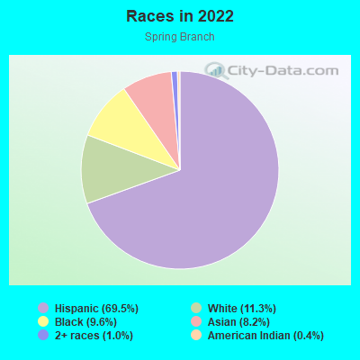
- 4,95869.5%Hispanic or Latino
- 80311.3%White
- 6849.6%Black
- 5868.2%Asian
- 711.0%Two or more races
- 290.4%American Indian
Median household income in 2022:
| Spring Branch: | $91,096 |
| Houston: | $60,426 |
Distribution of median household income
![Distribution of median household income]()
- 111Less than $10,000
- 144$10,000 to $19,999
- 208$20,000 to $29,999
- 64$30,000 to $39,999
- 137$40,000 to $49,999
- 208$50,000 to $59,999
- 245$60,000 to $74,999
- 339$75,000 to $99,999
- 175$100,000 to $124,999
- 100$125,000 to $149,999
- 219$150,000 to $199,999
- 240$200,000 or more

Distribution of owner-occupied house/condo value
![Distribution of owner-occupied house/condo value]()
- 373Less than $50,000
- 447$50,000 to $99,999
- 225$100,000 to $149,999
- 257$150,000 to $199,999
- 377$200,000 to $249,999
- 238$250,000 to $299,999
- 99$300,000 to $399,999
- 571$400,000 to $499,999
- 243$500,000 to $749,999
- 9$750,000 to $999,999
- 6$1,000,000 or more

Distribution of rent paid by renters
![Distribution of rent paid by renters]()
- 58$400 to $499
- 54$600 to $699
- 80$800 to $899
- 670$900 to $999
- 342$1,000 to $1,249
- 84$1,250 to $1,499
- 72$1,500 to $1,999
- 86$2,000 or more

Median rent in 2022:
| Spring Branch: | $1,155 |
| Houston: | $1,089 |
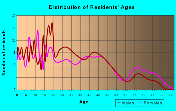
| Males: | 3,847 |
| Females: | 2,957 |
Males:
| This neighborhood: | 39.5 years |
| Whole city: | 34.4 years |
| This neighborhood: | 38.6 years |
| Whole city: | 34.7 years |
Average household size:
| Spring Branch: | 2.8 people |
| Houston: | 2.4 people |
Percentage of family households:
| Spring Branch: | 55.8% |
| Houston: | 43.0% |
| Here: | 49.4% |
| Houston: | 34.7% |
Percentage of married-couple families with children (among all households):
| Spring Branch: | 24.9% |
| Houston: | 23.3% |
Percentage of single-mother households (among all households):
| Spring Branch: | 4.5% |
| Houston: | 13.9% |
Percentage of never married males 15 years old and over:
Percentage of never married females 15 years old and over:
| Spring Branch: | 23.7% |
| Houston: | 22.9% |
Percentage of never married females 15 years old and over:
| Spring Branch: | 18.8% |
| city: | 21.2% |
Percentage of people that speak English not well or not at all:
| Spring Branch: | 15.6% |
| Houston: | 15.9% |
Percentage of people born in this state:
Percentage of people born in another U.S. state:
Percentage of native residents but born outside the U.S.:
Percentage of foreign born residents:
| Here: | 43.5% |
| Houston: | 51.1% |
Percentage of people born in another U.S. state:
| Spring Branch: | 12.1% |
| Houston: | 17.7% |
Percentage of native residents but born outside the U.S.:
| Here: | 0.7% |
| city: | 1.8% |
Percentage of foreign born residents:
| Here: | 44.1% |
| Houston: | 29.4% |
Owner-occupied
Renter-occupied

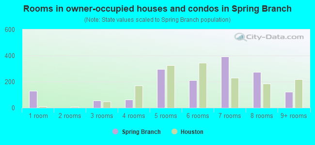
- Rooms in owner-occupied houses and condos in Spring Branch
- 1281 room
- 02 rooms
- 543 rooms
- 624 rooms
- 2965 rooms
- 2126 rooms
- 3937 rooms
- 2758 rooms
- 1239+ rooms
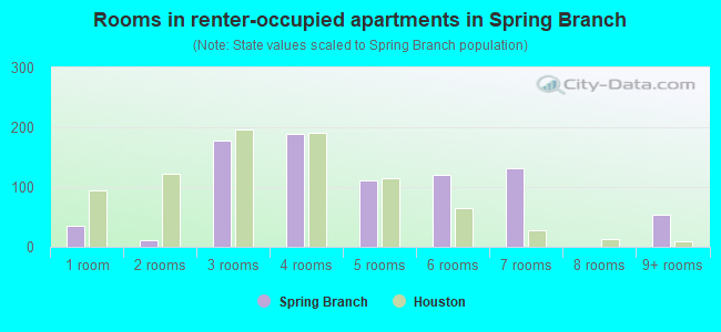
- Rooms in renter-occupied apartments in Spring Branch
- 361 room
- 112 rooms
- 1773 rooms
- 1894 rooms
- 1115 rooms
- 1216 rooms
- 1327 rooms
- 08 rooms
- 539+ rooms
Owner-occupied
Renter-occupied
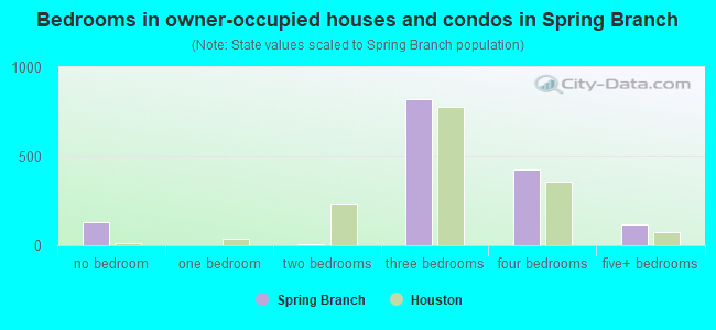
- Bedrooms in owner-occupied houses and condos in Spring Branch
- 128no bedroom
- 01 bedroom
- 62 bedrooms
- 8213 bedrooms
- 4244 bedrooms
- 1155+ bedrooms
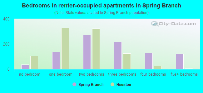
- Bedrooms in renter-occupied apartments in Spring Branch
- 36no bedroom
- 1391 bedroom
- 2722 bedrooms
- 2183 bedrooms
- 1294 bedrooms
- 1245+ bedrooms
Average number of cars or other vehicles available in houses/condos:
Average number of cars or other vehicles available in apartments:
| This neighborhood: | 2.5 |
| Houston: | 2.0 |
Average number of cars or other vehicles available in apartments:
| Here: | 2.5 |
| city: | 1.3 |
Percentage of units with a mortgage:
| Spring Branch: | 52.9% |
| Houston: | 50.8% |
Average estimated value of detached houses in 2022 (83.0% of all units):
| Spring Branch: | $215,777 |
| Houston: | $368,067 |
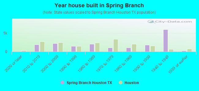
- Year house built in Spring Branch
- 02020 or later
- 3772010 to 2019
- 4372000 to 2009
- 2851990 to 1999
- 4111980 to 1989
- 2071970 to 1979
- 2101960 to 1969
- 3591950 to 1959
- 1,1821940 to 1949
- 511939 or earlier
City-data.com crime index for city in 2020 (higher means more crime):
| City: | 560.9 |
| U.S. average: | 219.5 |
Travel time to work (commute)
![Travel time to work (commute)]()
- 62Less than 5 minutes
- 865 to 9 minutes
- 28910 to 14 minutes
- 34215 to 19 minutes
- 20420 to 24 minutes
- 14825 to 29 minutes
- 40730 to 34 minutes
- 13335 to 39 minutes
- 13540 to 44 minutes
- 30245 to 59 minutes
- 13660 to 89 minutes
- 9090 or more minutes

Means of transportation to work
![Means of transportation to work]()
- 76.9%2,467Drove a car alone
- 14.3%458Carpooled
- 0.9%28Bus
- 1.1%36Motorcycle
- 0.7%22Walked
- 2.5%79Other means
- 5.7%182Worked at home

Time leaving home to go to work
![Time leaving home to go to work]()
- 21812:00 a.m. to 4:59 a.m.
- 2115:00 a.m. to 5:29 a.m.
- 1675:30 a.m. to 5:59 a.m.
- 2366:00 a.m. to 6:29 a.m.
- 2006:30 a.m. to 6:59 a.m.
- 4817:00 a.m. to 7:29 a.m.
- 1677:30 a.m. to 7:59 a.m.
- 2428:00 a.m. to 8:29 a.m.
- 598:30 a.m. to 8:59 a.m.
- 1669:00 a.m. to 9:59 a.m.
- 4710:00 a.m. to 10:59 a.m.
- 4811:00 a.m. to 11:59 a.m.
- 10912:00 p.m. to 3:59 p.m.
- 704:00 p.m. to 11:59 p.m.

Occupations of males:
- Percentage of males in management occupations (except farmers):
Here: 9.1% city: 10.6%
- Percentage of males in business and financial operations occupations:
Here: 1.3% city: 5.4%
- Percentage of males in computer and mathematical occupations:
Here: 6.3% city: 3.9%
- Percentage of males in education, training, and library occupations:
Here: 5.3% city: 3.1%
- Percentage of males in service occupations:
Here: 13.5% city: 12.9%
- Percentage of males in sales and office occupations:
Here: 7.6% city: 13.5%
- Percentage of males in construction, extraction, and maintenance occupations:
Here: 23.7% city: 15.7%
- Percentage of males in production occupations:
Here: 11.0% city: 6.0%
- Percentage of males in transportation occupations:
Here: 5.9% city: 6.1%
- Percentage of males in material moving occupations:
Here: 4.1% city: 5.4%
Occupations of females:
- Percentage of females in management occupations (except farmers):
Here: 6.9% city: 8.6%
- Percentage of females in business and financial operations occupations:
Here: 2.8% city: 6.8%
- Percentage of females in computer and mathematical occupations:
Here: 9.8% city: 1.7%
- Percentage of females in education, training, and library occupations:
Here: 6.9% city: 8.5%
- Percentage of females in healthcare practitioners and technical occupations:
Here: 7.7% city: 8.1%
- Percentage of females in service occupations:
Here: 39.1% city: 23.8%
- Percentage of females in sales and office occupations:
Here: 15.4% city: 26.6%
- Percentage of females in construction, extraction, and maintenance occupations:
Here: 3.3% city: 0.7%
- Percentage of females in production occupations:
Here: 1.3% city: 2.6%
- Percentage of females in transportation occupations:
Here: 3.4% city: 1.2%
- Percentage of females in material moving occupations:
Here: 1.5% city: 2.5%
Percentage of people 16-64 in Armed Forces:
| Spring Branch: | 0.2% |
| Houston: | 0.1% |
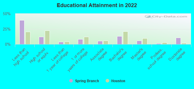
Education in this neighborhood (subdivision or community):
- Percentage of people 3 years and older in K-12 schools:
Spring Branch: 27.8% Houston: 16.6%
- Percentage of people 3 years and older in undergraduate colleges:
Spring Branch: 4.5% Houston: 4.6%
- Percentage of people 3 years and older in grad. or professional schools:
Spring Branch: 0.3% Houston: 1.6%
- Percentage of students K-12 enrolled in private schools:
Spring Branch: 11.0% Houston: 9.0%
Percentage of population below poverty level:
| Spring Branch: | 8.7% |
| Houston: | 20.7% |
Median year owner moved in (as recorded in 2022):
Median year renter moved in (as recorded in 2022):
| Spring Branch: | 2004 |
| Houston: | 2010 |
Median year renter moved in (as recorded in 2022):
| Spring Branch: | 2015 |
| Houston: | 2020 |
Percentage of married-couple families with both working:
| Spring Branch: | 36.7% |
| Houston: | 54.9% |
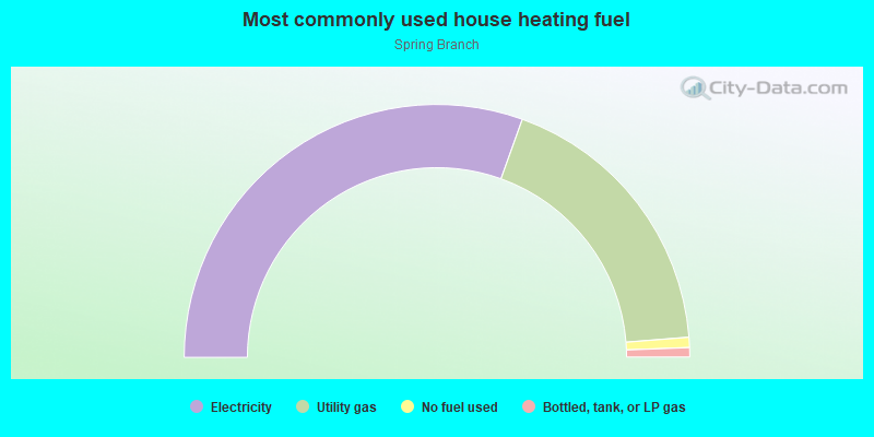
- 60.9%Electricity
- 36.5%Utility gas
- 1.3%No fuel used
- 1.2%Bottled, tank, or LP gas
Highways in this neighborhood:
Beltway 8 (State Loop 8, Sam Houston Pkwy)
Length: 0.97 miles
Directions: E-W, N-S, SW-NE
Directions: E-W, N-S, SW-NE
Roads and streets:
Sommermeyer St
Length: 2.08 miles
Directions: E-W, SE-NW
Address range: 14200 to 15199
Directions: E-W, SE-NW
Address range: 14200 to 15199
Hempstead Rd (Hempstead Hwy)
Length: 2.01 miles
Direction: SE-NW
Address range: 14200 to 15618
Direction: SE-NW
Address range: 14200 to 15618
Gessner Dr (Gessner Rd)
Length: 1.21 miles
Directions: N-S, SW-NE
Address range: 5400 to 6371
Directions: N-S, SW-NE
Address range: 5400 to 6371
Windfern Rd
Length: 1.14 miles
Directions: N-S, SW-NE
Address range: 4686 to 5999
Directions: N-S, SW-NE
Address range: 4686 to 5999
Okanella St
Length: 1.03 miles
Directions: E-W, SE-NW, SW-NE
Address range: 10100 to 10599
Directions: E-W, SE-NW, SW-NE
Address range: 10100 to 10599
Genard Rd
Length: 1.00 miles
Directions: E-W, SW-NE
Address range: 9800 to 10199
Directions: E-W, SW-NE
Address range: 9800 to 10199
Teague Rd
Length: 0.96 miles
Directions: N-S, SW-NE
Address range: 1301 to 6199
Directions: N-S, SW-NE
Address range: 1301 to 6199
Campbell Rd
Length: 0.95 miles
Directions: N-S, SE-NW, SW-NE
Address range: 4800 to 5799
Directions: N-S, SE-NW, SW-NE
Address range: 4800 to 5799
Hempstead Rd
Length: 0.93 miles
Direction: SE-NW
Address range: 14172 to 15147
Direction: SE-NW
Address range: 14172 to 15147
Tanner Rd
Length: 0.90 miles
Direction: E-W
Address range: 9500 to 10199
Direction: E-W
Address range: 9500 to 10199
Hollow Hook Rd
Length: 0.85 miles
Directions: E-W, N-S, SE-NW
Address range: 4300 to 5099
Directions: E-W, N-S, SE-NW
Address range: 4300 to 5099
Talina Way
Length: 0.85 miles
Directions: E-W, N-S, SE-NW
Address range: 4300 to 5099
Directions: E-W, N-S, SE-NW
Address range: 4300 to 5099
Papalote St
Length: 0.80 miles
Directions: E-W, SE-NW, SW-NE
Address range: 10000 to 10499
Directions: E-W, SE-NW, SW-NE
Address range: 10000 to 10499
W Little York Rd
Length: 0.73 miles
Direction: E-W
Address range: 10300 to 10629
Direction: E-W
Address range: 10300 to 10629
Porto Rico Rd
Length: 0.71 miles
Direction: E-W
Address range: 9800 to 10199
Direction: E-W
Address range: 9800 to 10199
Fisher Rd
Length: 0.71 miles
Direction: N-S
Address range: 10527 to 10555
Direction: N-S
Address range: 10527 to 10555
Burnside Ln
Length: 0.58 miles
Directions: E-W, N-S, SW-NE
Address range: 5400 to 10199
Directions: E-W, N-S, SW-NE
Address range: 5400 to 10199
Algiers Rd
Length: 0.53 miles
Direction: E-W
Address range: 9300 to 10199
Direction: E-W
Address range: 9300 to 10199
Senate St
Length: 0.53 miles
Direction: N-S
Direction: N-S
Bus Park Dr
Length: 0.51 miles
Directions: E-W, N-S
Address range: 6914 to 7199
Directions: E-W, N-S
Address range: 6914 to 7199
Bamboo Rd
Length: 0.50 miles
Direction: E-W
Address range: 9690 to 10199
Direction: E-W
Address range: 9690 to 10199
W Wingfoot Rd
Length: 0.49 miles
Direction: E-W
Address range: 9500 to 9799
Direction: E-W
Address range: 9500 to 9799
Crawford Rd
Length: 0.49 miles
Direction: N-S
Address range: 5826 to 6099
Direction: N-S
Address range: 5826 to 6099
Triway Ln
Length: 0.43 miles
Direction: N-S
Direction: N-S
Tangiers Rd
Length: 0.43 miles
Direction: E-W
Address range: 9900 to 10199
Direction: E-W
Address range: 9900 to 10199
Clara Rd
Length: 0.43 miles
Direction: N-S
Address range: 6300 to 6499
Direction: N-S
Address range: 6300 to 6499
Dancy Rd
Length: 0.39 miles
Direction: N-S
Direction: N-S
Olga Ln
Length: 0.38 miles
Directions: E-W, N-S, SW-NE
Address range: 10100 to 10499
Directions: E-W, N-S, SW-NE
Address range: 10100 to 10499
Alfred Ln
Length: 0.35 miles
Directions: E-W, SW-NE
Address range: 10000 to 10199
Directions: E-W, SW-NE
Address range: 10000 to 10199
Hardison Ln
Length: 0.35 miles
Directions: E-W, SW-NE
Address range: 10000 to 10199
Directions: E-W, SW-NE
Address range: 10000 to 10199
Comanche Ln
Length: 0.35 miles
Directions: E-W, SW-NE
Address range: 10000 to 10199
Directions: E-W, SW-NE
Address range: 10000 to 10199
Chickasaw Ln
Length: 0.35 miles
Directions: E-W, SW-NE
Address range: 10000 to 10199
Directions: E-W, SW-NE
Address range: 10000 to 10199
Sussex Ln
Length: 0.35 miles
Directions: E-W, SW-NE
Address range: 10000 to 10199
Directions: E-W, SW-NE
Address range: 10000 to 10199
Grover Ln
Length: 0.35 miles
Directions: E-W, SW-NE
Address range: 10000 to 10199
Directions: E-W, SW-NE
Address range: 10000 to 10199
Clay Rd
Length: 0.35 miles
Direction: E-W
Address range: 9930 to 10029
Direction: E-W
Address range: 9930 to 10029
Talley Ln
Length: 0.34 miles
Direction: E-W
Address range: 10000 to 10199
Direction: E-W
Address range: 10000 to 10199
Morocco Rd
Length: 0.31 miles
Direction: E-W
Address range: 10000 to 10199
Direction: E-W
Address range: 10000 to 10199
Vallen Dr
Length: 0.30 miles
Direction: E-W
Direction: E-W
Perimeter Park Dr
Length: 0.28 miles
Directions: N-S, SW-NE
Address range: 6901 to 7131
Directions: N-S, SW-NE
Address range: 6901 to 7131
Sweetbay Ln
Length: 0.22 miles
Directions: E-W, N-S, SE-NW
Address range: 5500 to 5599
Directions: E-W, N-S, SE-NW
Address range: 5500 to 5599
Dierker Dr
Length: 0.22 miles
Directions: N-S, SW-NE
Address range: 5800 to 5899
Directions: N-S, SW-NE
Address range: 5800 to 5899
Roxburgh Dr
Length: 0.21 miles
Direction: N-S
Address range: 6600 to 6699
Direction: N-S
Address range: 6600 to 6699
Nyoka St
Length: 0.20 miles
Direction: N-S
Address range: 6200 to 6323
Direction: N-S
Address range: 6200 to 6323
Softwind Rd
Length: 0.20 miles
Direction: N-S
Address range: 5500 to 5699
Direction: N-S
Address range: 5500 to 5699
Drysdale Ln
Length: 0.18 miles
Direction: E-W
Address range: 9800 to 9899
Direction: E-W
Address range: 9800 to 9899
Park Entry Dr
Length: 0.16 miles
Directions: E-W, SE-NW
Directions: E-W, SE-NW
Keyko St
Length: 0.16 miles
Directions: N-S, SW-NE
Address range: 6200 to 6299
Directions: N-S, SW-NE
Address range: 6200 to 6299
Perimeter West Dr
Length: 0.15 miles
Direction: E-W
Direction: E-W
Goodrum Rd
Length: 0.12 miles
Direction: E-W
Address range: 10100 to 10199
Direction: E-W
Address range: 10100 to 10199
Rockcrest Dr (Rockcrest Rd)
Length: 0.12 miles
Direction: E-W
Direction: E-W
Lybert Rd
Length: 0.08 miles
Direction: E-W
Direction: E-W
Lybert Dr
Length: 0.08 miles
Direction: E-W
Address range: 10100 to 10199
Direction: E-W
Address range: 10100 to 10199
Hillcrest Rd
Length: 0.04 miles
Direction: E-W
Direction: E-W
Crossover
Length: 0.03 miles
Direction: SW-NE
Direction: SW-NE
Railroad features:
Southern Pacific RR
Length: 3.11 miles
Directions: E-W, SE-NW
Directions: E-W, SE-NW
Other features:
Cole Crk
Length: 0.79 miles
Directions: E-W, N-S, SW-NE
Directions: E-W, N-S, SW-NE