Spring Branch West neighborhood in Houston, Texas (TX), 77043, 77055, 77080 detailed profile
Settings
X


Business Search - 14 Million verified businesses
Area: 7.445 square miles
Population: 16,999
Population density:
| Spring Branch West: | 2,283 people per square mile |
| Houston: | 3,977 people per square mile |

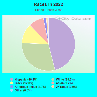
- 8,07046.1%Hispanic or Latino
- 5,19329.6%White
- 2,09612.0%Black
- 1,6119.2%Asian
- 2961.7%American Indian
- 1650.9%Two or more races
- 910.5%Some other race
Median household income in 2022:
| Spring Branch West: | $133,287 |
| Houston: | $60,426 |
Distribution of median household income
![Distribution of median household income]()
- 181Less than $10,000
- 866$10,000 to $19,999
- 969$20,000 to $29,999
- 908$30,000 to $39,999
- 709$40,000 to $49,999
- 225$50,000 to $59,999
- 886$60,000 to $74,999
- 604$75,000 to $99,999
- 712$100,000 to $124,999
- 195$125,000 to $149,999
- 282$150,000 to $199,999
- 839$200,000 or more

Distribution of owner-occupied house/condo value
![Distribution of owner-occupied house/condo value]()
- 263Less than $50,000
- 687$50,000 to $99,999
- 820$100,000 to $149,999
- 502$150,000 to $199,999
- 1,117$200,000 to $249,999
- 143$250,000 to $299,999
- 400$300,000 to $399,999
- 243$400,000 to $499,999
- 918$500,000 to $749,999
- 2,985$750,000 to $999,999
- 3,315$1,000,000 or more

Distribution of rent paid by renters
![Distribution of rent paid by renters]()
- 143$400 to $499
- 527$500 to $599
- 2,151$600 to $699
- 593$700 to $799
- 157$800 to $899
- 695$900 to $999
- 1,356$1,000 to $1,249
- 846$1,250 to $1,499
- 256$1,500 to $1,999
- 2,489$2,000 or more

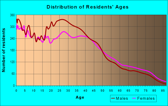
| Males: | 8,483 |
| Females: | 8,516 |
Males:
| This neighborhood: | 37.2 years |
| Whole city: | 34.4 years |
| This neighborhood: | 36.8 years |
| Whole city: | 34.7 years |
Average household size:
| Spring Branch West: | 9.0 people |
| Houston: | 2.4 people |
Percentage of family households:
| Spring Branch West: | 48.3% |
| Houston: | 43.0% |
| Here: | 39.2% |
| Houston: | 34.7% |
Percentage of married-couple families with children (among all households):
| Spring Branch West: | 27.7% |
| Houston: | 23.3% |
Percentage of single-mother households (among all households):
| Spring Branch West: | 13.0% |
| Houston: | 13.9% |
Percentage of never married males 15 years old and over:
Percentage of never married females 15 years old and over:
| Spring Branch West: | 18.2% |
| Houston: | 22.9% |
Percentage of never married females 15 years old and over:
| Spring Branch West: | 21.1% |
| city: | 21.2% |
Percentage of people that speak English not well or not at all:
| Spring Branch West: | 12.2% |
| Houston: | 15.9% |
Percentage of people born in this state:
Percentage of people born in another U.S. state:
Percentage of native residents but born outside the U.S.:
Percentage of foreign born residents:
| Here: | 45.5% |
| Houston: | 51.1% |
Percentage of people born in another U.S. state:
| Spring Branch West: | 20.8% |
| Houston: | 17.7% |
Percentage of native residents but born outside the U.S.:
| Here: | 2.4% |
| city: | 1.8% |
Percentage of foreign born residents:
| Here: | 31.3% |
| Houston: | 29.4% |
Owner-occupied
Renter-occupied

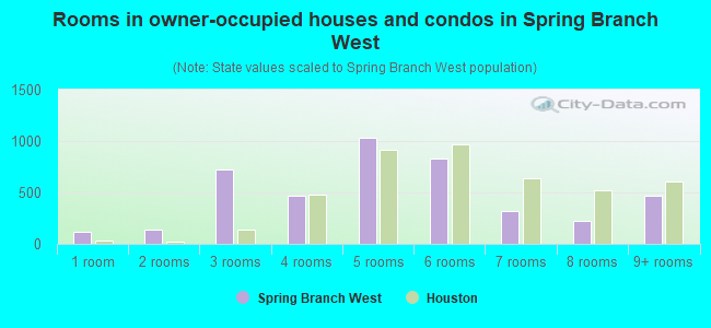
- Rooms in owner-occupied houses and condos in Spring Branch West
- 1141 room
- 1382 rooms
- 7263 rooms
- 4684 rooms
- 1,0295 rooms
- 8356 rooms
- 3247 rooms
- 2228 rooms
- 4639+ rooms
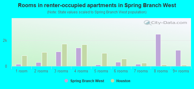
- Rooms in renter-occupied apartments in Spring Branch West
- 1581 room
- 2872 rooms
- 1,1273 rooms
- 1,4304 rooms
- 1225 rooms
- 3206 rooms
- 1547 rooms
- 2,4738 rooms
- 1,2319+ rooms
Owner-occupied
Renter-occupied
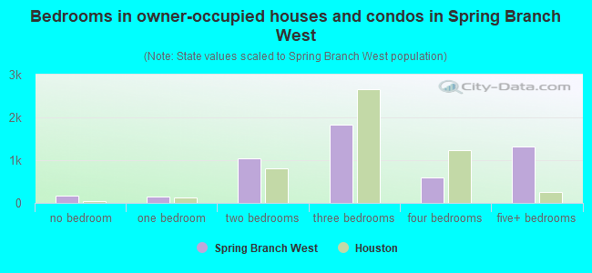
- Bedrooms in owner-occupied houses and condos in Spring Branch West
- 174no bedroom
- 1581 bedroom
- 1,0402 bedrooms
- 1,8253 bedrooms
- 5894 bedrooms
- 1,3115+ bedrooms
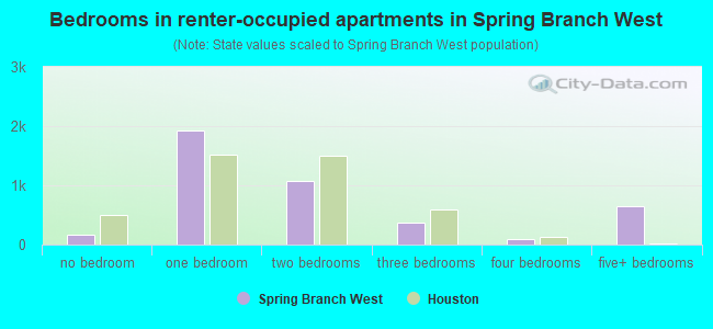
- Bedrooms in renter-occupied apartments in Spring Branch West
- 158no bedroom
- 1,9211 bedroom
- 1,0812 bedrooms
- 3663 bedrooms
- 944 bedrooms
- 6475+ bedrooms
Average number of cars or other vehicles available in houses/condos:
Average number of cars or other vehicles available in apartments:
| This neighborhood: | 2.2 |
| Houston: | 2.0 |
Average number of cars or other vehicles available in apartments:
| Here: | |
| city: |
Percentage of units with a mortgage:
| Spring Branch West: | 41.4% |
| Houston: | 50.8% |
Average estimated value of detached houses in 2022 (41.9% of all units):
| Spring Branch West: | $458,973 |
| Houston: | $368,067 |
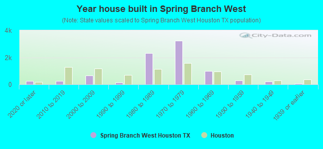
- Year house built in Spring Branch West
- 2562020 or later
- 2412010 to 2019
- 6632000 to 2009
- 1331990 to 1999
- 2,3191980 to 1989
- 3,2241970 to 1979
- 9811960 to 1969
- 3011950 to 1959
- 2031940 to 1949
- 631939 or earlier
City-data.com crime index for city in 2020 (higher means more crime):
| City: | 560.9 |
| U.S. average: | 219.5 |
Travel time to work (commute)
![Travel time to work (commute)]()
- 308Less than 5 minutes
- 7005 to 9 minutes
- 68810 to 14 minutes
- 1,31415 to 19 minutes
- 1,53720 to 24 minutes
- 80125 to 29 minutes
- 1,49330 to 34 minutes
- 28235 to 39 minutes
- 27040 to 44 minutes
- 56445 to 59 minutes
- 58760 to 89 minutes
- 17590 or more minutes

Means of transportation to work
![Means of transportation to work]()
- 78.7%6,609Drove a car alone
- 15.1%1,266Carpooled
- 1.2%103Bus
- 2.9%246Taxi
- 1.1%90Motorcycle
- 3.4%282Bicycle
- 3.8%318Walked
- 0.6%54Other means
- 4.6%388Worked at home

Time leaving home to go to work
![Time leaving home to go to work]()
- 24412:00 a.m. to 4:59 a.m.
- 3175:00 a.m. to 5:29 a.m.
- 2995:30 a.m. to 5:59 a.m.
- 6506:00 a.m. to 6:29 a.m.
- 9616:30 a.m. to 6:59 a.m.
- 1,4577:00 a.m. to 7:29 a.m.
- 1,3147:30 a.m. to 7:59 a.m.
- 1,3518:00 a.m. to 8:29 a.m.
- 3948:30 a.m. to 8:59 a.m.
- 5069:00 a.m. to 9:59 a.m.
- 37210:00 a.m. to 10:59 a.m.
- 11511:00 a.m. to 11:59 a.m.
- 26912:00 p.m. to 3:59 p.m.
- 2054:00 p.m. to 11:59 p.m.

Occupations of males:
- Percentage of males in management occupations (except farmers):
Here: 8.5% city: 10.6%
- Percentage of males in business and financial operations occupations:
Here: 8.3% city: 5.4%
- Percentage of males in computer and mathematical occupations:
Here: 2.9% city: 3.9%
- Percentage of males in architecture and engineering occupations:
Here: 1.1% city: 4.0%
- Percentage of males in legal occupations:
Here: 1.5% city: 1.4%
- Percentage of males in education, training, and library occupations:
Here: 2.9% city: 3.1%
- Percentage of males in healthcare practitioners and technical occupations:
Here: 1.5% city: 2.7%
- Percentage of males in service occupations:
Here: 11.2% city: 12.9%
- Percentage of males in sales and office occupations:
Here: 15.5% city: 13.5%
- Percentage of males in construction, extraction, and maintenance occupations:
Here: 16.0% city: 15.7%
- Percentage of males in production occupations:
Here: 9.3% city: 6.0%
- Percentage of males in transportation occupations:
Here: 4.2% city: 6.1%
- Percentage of males in material moving occupations:
Here: 8.1% city: 5.4%
Occupations of females:
- Percentage of females in management occupations (except farmers):
Here: 11.5% city: 8.6%
- Percentage of females in business and financial operations occupations:
Here: 6.8% city: 6.8%
- Percentage of females in community and social services occupations:
Here: 1.7% city: 1.8%
- Percentage of females in education, training, and library occupations:
Here: 3.7% city: 8.5%
- Percentage of females in arts, design, entertainment, sports, and media occupations:
Here: 1.5% city: 2.0%
- Percentage of females in healthcare practitioners and technical occupations:
Here: 2.1% city: 8.1%
- Percentage of females in service occupations:
Here: 37.7% city: 23.8%
- Percentage of females in sales and office occupations:
Here: 11.2% city: 26.6%
- Percentage of females in construction, extraction, and maintenance occupations:
Here: 4.2% city: 0.7%
- Percentage of females in production occupations:
Here: 3.1% city: 2.6%
- Percentage of females in transportation occupations:
Here: 7.1% city: 1.2%
- Percentage of females in material moving occupations:
Here: 7.7% city: 2.5%
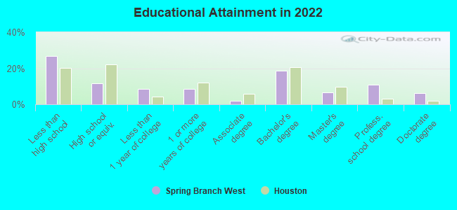
Education in this neighborhood (subdivision or community):
- Percentage of people 3 years and older in K-12 schools:
Spring Branch West: 21.1% Houston: 16.6%
- Percentage of people 3 years and older in undergraduate colleges:
Spring Branch West: 1.8% Houston: 4.6%
- Percentage of people 3 years and older in grad. or professional schools:
Spring Branch West: 3.5% Houston: 1.6%
- Percentage of students K-12 enrolled in private schools:
Spring Branch West: 77.3% Houston: 9.0%
Percentage of population below poverty level:
| Spring Branch West: | 10.5% |
| Houston: | 20.7% |
Median year owner moved in (as recorded in 2022):
| Spring Branch West: | 2006 |
| Houston: | 2010 |
Percentage of married-couple families with both working:
| Spring Branch West: | 104.5% |
| Houston: | 54.9% |
- 50.5%Electricity
- 44.6%Utility gas
- 1.9%Wood
- 1.7%Bottled, tank, or LP gas
- 0.7%No fuel used
- 0.6%Other fuel
Limited-access highways (interstate or state) in this neighborhood:
Katy Fwy (I- 10, US Hwy 90)
Length: 12.39 miles
Direction: E-W
Direction: E-W
Highways in this neighborhood:
State Loop 8 (Sam Houston Pkwy, Beltway 8)
Length: 3.76 miles
Direction: N-S
Direction: N-S
Roads and streets:
Old Katy Rd
Length: 4.49 miles
Directions: E-W, N-S, SE-NW, SW-NE
Address range: 9400 to 11399
Directions: E-W, N-S, SE-NW, SW-NE
Address range: 9400 to 11399
Shadowdale Dr
Length: 3.13 miles
Directions: E-W, N-S, SE-NW
Address range: 1100 to 2215
Directions: E-W, N-S, SE-NW
Address range: 1100 to 2215
Brittmoore Rd
Length: 3.11 miles
Direction: N-S
Address range: 1000 to 4047
Direction: N-S
Address range: 1000 to 4047
Westview Dr
Length: 2.88 miles
Directions: E-W, SE-NW, SW-NE
Address range: 9382 to 10799
Directions: E-W, SE-NW, SW-NE
Address range: 9382 to 10799
Shadow Wood Dr
Length: 2.27 miles
Directions: E-W, N-S, SE-NW, SW-NE
Address range: 9700 to 10999
Directions: E-W, N-S, SE-NW, SW-NE
Address range: 9700 to 10999
Hazelhurst Dr
Length: 1.98 miles
Directions: E-W, N-S, SE-NW, SW-NE
Address range: 9900 to 11199
Directions: E-W, N-S, SE-NW, SW-NE
Address range: 9900 to 11199
Gessner Dr (Gessner Rd)
Length: 1.90 miles
Direction: N-S
Address range: 1000 to 2151
Direction: N-S
Address range: 1000 to 2151
Long Point Rd
Length: 1.74 miles
Direction: E-W
Address range: 9400 to 10199
Direction: E-W
Address range: 9400 to 10199
Sherwood Forest St
Length: 1.64 miles
Directions: E-W, N-S, SE-NW, SW-NE
Address range: 1000 to 2099
Directions: E-W, N-S, SE-NW, SW-NE
Address range: 1000 to 2099
Wycliffe Dr
Length: 1.64 miles
Direction: N-S
Address range: 1000 to 2299
Direction: N-S
Address range: 1000 to 2299
Knoboak Dr
Length: 1.53 miles
Directions: E-W, SE-NW, SW-NE
Address range: 10100 to 10799
Directions: E-W, SE-NW, SW-NE
Address range: 10100 to 10799
Witte Rd
Length: 1.50 miles
Direction: N-S
Address range: 1000 to 1899
Direction: N-S
Address range: 1000 to 1899
Conrad Sauer Dr
Length: 1.38 miles
Direction: N-S
Address range: 1000 to 1799
Direction: N-S
Address range: 1000 to 1799
Upland Dr
Length: 1.26 miles
Directions: N-S, SE-NW
Address range: 1000 to 1999
Directions: N-S, SE-NW
Address range: 1000 to 1999
Warwana Rd
Length: 1.24 miles
Direction: E-W
Address range: 9700 to 10899
Direction: E-W
Address range: 9700 to 10899
Cedardale Dr
Length: 1.16 miles
Directions: E-W, SW-NE
Address range: 9600 to 10099
Directions: E-W, SW-NE
Address range: 9600 to 10099
Blalock Rd
Length: 1.14 miles
Directions: N-S, SE-NW
Address range: 2 to 1766
Directions: N-S, SE-NW
Address range: 2 to 1766
Metronome Dr
Length: 1.10 miles
Directions: E-W, N-S, SW-NE
Address range: 10100 to 11099
Directions: E-W, N-S, SW-NE
Address range: 10100 to 11099
Haddington Dr
Length: 1.10 miles
Directions: E-W, SW-NE
Address range: 10000 to 10799
Directions: E-W, SW-NE
Address range: 10000 to 10799
Mayfield Rd
Length: 1.10 miles
Directions: E-W, N-S, SE-NW, SW-NE
Address range: 10200 to 11299
Directions: E-W, N-S, SE-NW, SW-NE
Address range: 10200 to 11299
Ivyridge Rd
Length: 1.08 miles
Directions: E-W, N-S, SE-NW
Address range: 10200 to 11299
Directions: E-W, N-S, SE-NW
Address range: 10200 to 11299
Larston St
Length: 1.07 miles
Directions: E-W, N-S, SW-NE
Address range: 9600 to 10399
Directions: E-W, N-S, SW-NE
Address range: 9600 to 10399
Timberoak Dr
Length: 1.00 miles
Direction: E-W
Address range: 10000 to 10999
Direction: E-W
Address range: 10000 to 10999
Chatterton Dr
Length: 0.99 miles
Direction: E-W
Address range: 10100 to 11199
Direction: E-W
Address range: 10100 to 11199
Tiger Trl
Length: 0.98 miles
Directions: E-W, N-S, SE-NW
Address range: 10200 to 10599
Directions: E-W, N-S, SE-NW
Address range: 10200 to 10599
Bunker Hill Rd
Length: 0.95 miles
Directions: N-S, SE-NW, SW-NE
Address range: 1000 to 1399
Directions: N-S, SE-NW, SW-NE
Address range: 1000 to 1399
Oak Tree Dr
Length: 0.93 miles
Directions: E-W, N-S, SE-NW
Address range: 1100 to 1633
Directions: E-W, N-S, SE-NW
Address range: 1100 to 1633
Pine Lake Dr
Length: 0.92 miles
Directions: E-W, SW-NE
Address range: 9600 to 9999
Directions: E-W, SW-NE
Address range: 9600 to 9999
Maux Dr
Length: 0.89 miles
Directions: E-W, N-S, SE-NW, SW-NE
Address range: 1400 to 1999
Directions: E-W, N-S, SE-NW, SW-NE
Address range: 1400 to 1999
Moorberry Ln
Length: 0.86 miles
Directions: E-W, N-S, SE-NW
Address range: 2000 to 10599
Directions: E-W, N-S, SE-NW
Address range: 2000 to 10599
Brinwood Dr
Length: 0.86 miles
Directions: E-W, N-S, SE-NW, SW-NE
Address range: 10100 to 10699
Directions: E-W, N-S, SE-NW, SW-NE
Address range: 10100 to 10699
Cedar Post Ln
Length: 0.85 miles
Directions: E-W, N-S, SE-NW
Address range: 1200 to 1499
Directions: E-W, N-S, SE-NW
Address range: 1200 to 1499
Stebbins Dr
Length: 0.80 miles
Directions: N-S, SE-NW, SW-NE
Address range: 1652 to 2099
Directions: N-S, SE-NW, SW-NE
Address range: 1652 to 2099
Eddystone Dr
Length: 0.80 miles
Direction: E-W
Address range: 10100 to 10599
Direction: E-W
Address range: 10100 to 10599
Shadow Bend Dr
Length: 0.79 miles
Directions: E-W, N-S, SE-NW
Address range: 1400 to 2099
Directions: E-W, N-S, SE-NW
Address range: 1400 to 2099
Rollingwood Dr
Length: 0.74 miles
Directions: E-W, N-S, SE-NW, SW-NE
Address range: 1 to 64
Directions: E-W, N-S, SE-NW, SW-NE
Address range: 1 to 64
Lumpkin Rd
Length: 0.70 miles
Directions: N-S, SW-NE
Address range: 1000 to 1499
Directions: N-S, SW-NE
Address range: 1000 to 1499
Timberline Rd
Length: 0.68 miles
Directions: E-W, SE-NW
Address range: 10900 to 11299
Directions: E-W, SE-NW
Address range: 10900 to 11299
Wisterwood Dr
Length: 0.67 miles
Directions: E-W, N-S
Address range: 1000 to 1499
Directions: E-W, N-S
Address range: 1000 to 1499
Oakstream Dr
Length: 0.66 miles
Directions: E-W, N-S, SE-NW, SW-NE
Address range: 1000 to 1599
Directions: E-W, N-S, SE-NW, SW-NE
Address range: 1000 to 1599
Hammerly Blvd
Length: 0.66 miles
Direction: E-W
Address range: 10684 to 11098
Direction: E-W
Address range: 10684 to 11098
Neuens Rd
Length: 0.60 miles
Directions: E-W, N-S, SW-NE
Address range: 9938 to 10399
Directions: E-W, N-S, SW-NE
Address range: 9938 to 10399
Briarwild Ln
Length: 0.60 miles
Directions: E-W, N-S, SE-NW
Address range: 9800 to 10099
Directions: E-W, N-S, SE-NW
Address range: 9800 to 10099
Crestdale Dr
Length: 0.59 miles
Direction: N-S
Address range: 1400 to 1720
Direction: N-S
Address range: 1400 to 1720
Confederate Rd
Length: 0.59 miles
Directions: E-W, N-S, SW-NE
Address range: 1100 to 1499
Directions: E-W, N-S, SW-NE
Address range: 1100 to 1499
Spillers Ln
Length: 0.57 miles
Directions: N-S, SE-NW, SW-NE
Address range: 1300 to 2099
Directions: N-S, SE-NW, SW-NE
Address range: 1300 to 2099
Hanka Dr
Length: 0.55 miles
Direction: E-W
Address range: 10000 to 10199
Direction: E-W
Address range: 10000 to 10199
Whiteside Ln
Length: 0.55 miles
Direction: E-W
Address range: 10000 to 10199
Direction: E-W
Address range: 10000 to 10199
Raritan Dr
Length: 0.53 miles
Direction: E-W
Address range: 10000 to 10599
Direction: E-W
Address range: 10000 to 10599
Shadow Ln
Length: 0.50 miles
Directions: E-W, N-S, SE-NW, SW-NE
Address range: 1 to 23
Directions: E-W, N-S, SE-NW, SW-NE
Address range: 1 to 23
Springrock Ln
Length: 0.49 miles
Direction: N-S
Address range: 1100 to 1499
Direction: N-S
Address range: 1100 to 1499
Oak Point Dr
Length: 0.49 miles
Directions: E-W, N-S, SW-NE
Address range: 9700 to 10399
Directions: E-W, N-S, SW-NE
Address range: 9700 to 10399
Shadow Oaks Dr
Length: 0.49 miles
Directions: E-W, SE-NW, SW-NE
Address range: 10112 to 10599
Directions: E-W, SE-NW, SW-NE
Address range: 10112 to 10599
Nocturne Ln
Length: 0.48 miles
Direction: N-S
Address range: 1600 to 10099
Direction: N-S
Address range: 1600 to 10099
Scenic Ridge Dr
Length: 0.47 miles
Directions: E-W, N-S, SE-NW, SW-NE
Address range: 1400 to 1699
Directions: E-W, N-S, SE-NW, SW-NE
Address range: 1400 to 1699
Imperial Crown Dr
Length: 0.47 miles
Directions: E-W, N-S, SW-NE
Address range: 1500 to 1799
Directions: E-W, N-S, SW-NE
Address range: 1500 to 1799
Londonderry Dr
Length: 0.46 miles
Direction: E-W
Address range: 10200 to 10599
Direction: E-W
Address range: 10200 to 10599
Barwood Dr
Length: 0.45 miles
Directions: E-W, N-S
Address range: 10200 to 10599
Directions: E-W, N-S
Address range: 10200 to 10599
Claymoore Park Dr
Length: 0.44 miles
Directions: N-S, SW-NE
Address range: 3000 to 3999
Directions: N-S, SW-NE
Address range: 3000 to 3999
Moss Ridge Rd
Length: 0.44 miles
Direction: E-W
Address range: 10700 to 11999
Direction: E-W
Address range: 10700 to 11999
Mountain Rose Ln
Length: 0.42 miles
Directions: E-W, N-S, SE-NW, SW-NE
Address range: 3600 to 3999
Directions: E-W, N-S, SE-NW, SW-NE
Address range: 3600 to 3999
Mapleton Dr
Length: 0.40 miles
Direction: N-S
Address range: 1400 to 2099
Direction: N-S
Address range: 1400 to 2099
Clarborough Pl
Length: 0.39 miles
Directions: E-W, N-S, SW-NE
Directions: E-W, N-S, SW-NE
Timberwood Dr
Length: 0.39 miles
Direction: E-W
Address range: 10000 to 10599
Direction: E-W
Address range: 10000 to 10599
Long Branch Ln
Length: 0.38 miles
Direction: E-W
Address range: 9600 to 9799
Direction: E-W
Address range: 9600 to 9799
Shadeland Dr
Length: 0.37 miles
Direction: N-S
Address range: 1100 to 1499
Direction: N-S
Address range: 1100 to 1499
Stebbins Cir
Length: 0.37 miles
Directions: E-W, N-S, SE-NW
Address range: 10600 to 10699
Directions: E-W, N-S, SE-NW
Address range: 10600 to 10699
Springwood Forest Dr
Length: 0.37 miles
Direction: E-W
Address range: 10000 to 10198
Direction: E-W
Address range: 10000 to 10198
Butlercrest St
Length: 0.37 miles
Direction: N-S
Address range: 1400 to 1599
Direction: N-S
Address range: 1400 to 1599
Townhurst Dr
Length: 0.36 miles
Direction: N-S
Address range: 1600 to 1799
Direction: N-S
Address range: 1600 to 1799
Adkins Rd
Length: 0.34 miles
Direction: N-S
Address range: 1010 to 1211
Direction: N-S
Address range: 1010 to 1211
Peer Dr
Length: 0.34 miles
Directions: N-S, SE-NW
Address range: 1600 to 1899
Directions: N-S, SE-NW
Address range: 1600 to 1899
Tappenbeck Dr
Length: 0.32 miles
Directions: E-W, N-S, SE-NW, SW-NE
Address range: 9700 to 9799
Directions: E-W, N-S, SE-NW, SW-NE
Address range: 9700 to 9799
Mallard Dr
Length: 0.31 miles
Direction: N-S
Address range: 1800 to 2099
Direction: N-S
Address range: 1800 to 2099
Lazy Oaks St
Length: 0.31 miles
Direction: E-W
Address range: 10000 to 10099
Direction: E-W
Address range: 10000 to 10099
Dalecrest Dr
Length: 0.28 miles
Direction: E-W
Address range: 9500 to 9699
Direction: E-W
Address range: 9500 to 9699
Kempwood Dr
Length: 0.28 miles
Directions: E-W, SE-NW
Address range: 10699 to 10899
Directions: E-W, SE-NW
Address range: 10699 to 10899
S Fairhollow Ln
Length: 0.28 miles
Directions: E-W, N-S, SE-NW, SW-NE
Address range: 11800 to 12098
Directions: E-W, N-S, SE-NW, SW-NE
Address range: 11800 to 12098
Yupondale Dr (Yupondale St)
Length: 0.28 miles
Direction: E-W
Address range: 9500 to 9699
Direction: E-W
Address range: 9500 to 9699
Hollow Hook Rd
Length: 0.27 miles
Direction: N-S
Address range: 1666 to 2299
Direction: N-S
Address range: 1666 to 2299
Kerrwood Ln
Length: 0.27 miles
Direction: E-W
Address range: 10100 to 10199
Direction: E-W
Address range: 10100 to 10199
N Fairhollow Ln
Length: 0.27 miles
Directions: E-W, N-S, SE-NW, SW-NE
Address range: 11800 to 12056
Directions: E-W, N-S, SE-NW, SW-NE
Address range: 11800 to 12056
Bear Creek Meadows Ln
Length: 0.27 miles
Direction: N-S
Address range: 3800 to 4099
Direction: N-S
Address range: 3800 to 4099
Alcott Dr
Length: 0.26 miles
Directions: E-W, N-S
Address range: 10800 to 10899
Directions: E-W, N-S
Address range: 10800 to 10899
Day Rd
Length: 0.26 miles
Direction: E-W
Address range: 10922 to 10999
Direction: E-W
Address range: 10922 to 10999
Ridgeview Dr
Length: 0.26 miles
Direction: E-W
Address range: 10900 to 10999
Direction: E-W
Address range: 10900 to 10999
Western Village Ln
Length: 0.25 miles
Directions: N-S, SE-NW, SW-NE
Address range: 1900 to 2099
Directions: N-S, SE-NW, SW-NE
Address range: 1900 to 2099
Church Ln
Length: 0.25 miles
Direction: E-W
Address range: 10800 to 10899
Direction: E-W
Address range: 10800 to 10899
Fullerton Dr
Length: 0.25 miles
Direction: E-W
Address range: 10900 to 10999
Direction: E-W
Address range: 10900 to 10999
Ottawa Ln
Length: 0.25 miles
Directions: N-S, SE-NW
Address range: 1900 to 2033
Directions: N-S, SE-NW
Address range: 1900 to 2033
S Youngwood Ln
Length: 0.24 miles
Directions: E-W, N-S, SE-NW, SW-NE
Address range: 11800 to 12043
Directions: E-W, N-S, SE-NW, SW-NE
Address range: 11800 to 12043
N Youngwood Ln
Length: 0.24 miles
Directions: E-W, N-S, SE-NW, SW-NE
Address range: 11800 to 12060
Directions: E-W, N-S, SE-NW, SW-NE
Address range: 11800 to 12060
Moss Branch Rd
Length: 0.24 miles
Directions: E-W, SW-NE
Address range: 11800 to 12099
Directions: E-W, SW-NE
Address range: 11800 to 12099
Echo Grove Ln
Length: 0.24 miles
Directions: N-S, SE-NW, SW-NE
Address range: 3500 to 3999
Directions: N-S, SE-NW, SW-NE
Address range: 3500 to 3999
Pine Village Dr
Length: 0.24 miles
Direction: N-S
Address range: 1700 to 1799
Direction: N-S
Address range: 1700 to 1799
Bullock Ln
Length: 0.23 miles
Directions: E-W, N-S, SW-NE
Address range: 1300 to 1399
Directions: E-W, N-S, SW-NE
Address range: 1300 to 1399
Murrayhill Dr
Length: 0.23 miles
Direction: N-S
Address range: 1100 to 1499
Direction: N-S
Address range: 1100 to 1499
Parana Dr
Length: 0.23 miles
Direction: N-S
Address range: 1700 to 1799
Direction: N-S
Address range: 1700 to 1799
Northbrook Dr
Length: 0.23 miles
Direction: E-W
Address range: 10600 to 10699
Direction: E-W
Address range: 10600 to 10699
Kersten Dr
Length: 0.22 miles
Direction: N-S
Address range: 1450 to 1999
Direction: N-S
Address range: 1450 to 1999
Wood Hollow Ln
Length: 0.22 miles
Directions: E-W, SE-NW
Address range: 11800 to 12042
Directions: E-W, SE-NW
Address range: 11800 to 12042
Ganyard Dr
Length: 0.22 miles
Direction: N-S
Address range: 1800 to 2099
Direction: N-S
Address range: 1800 to 2099
Teague Rd
Length: 0.22 miles
Direction: N-S
Address range: 2000 to 2102
Direction: N-S
Address range: 2000 to 2102
Georgibelle Dr
Length: 0.21 miles
Direction: E-W
Address range: 10200 to 10299
Direction: E-W
Address range: 10200 to 10299
Southwick St
Length: 0.21 miles
Direction: N-S
Address range: 1400 to 2199
Direction: N-S
Address range: 1400 to 2199
Maple Springs Dr
Length: 0.21 miles
Directions: E-W, N-S, SE-NW
Address range: 11200 to 11331
Directions: E-W, N-S, SE-NW
Address range: 11200 to 11331
Windhover Ln
Length: 0.20 miles
Direction: N-S
Address range: 1100 to 1299
Direction: N-S
Address range: 1100 to 1299
Longhorn Dr
Length: 0.20 miles
Direction: N-S
Address range: 1400 to 2199
Direction: N-S
Address range: 1400 to 2199
Chaparral Dr
Length: 0.20 miles
Direction: N-S
Address range: 1900 to 2099
Direction: N-S
Address range: 1900 to 2099
Centennial Dr
Length: 0.20 miles
Direction: N-S
Address range: 1300 to 1399
Direction: N-S
Address range: 1300 to 1399
Buescher Dr
Length: 0.20 miles
Directions: E-W, N-S, SE-NW
Address range: 1300 to 1699
Directions: E-W, N-S, SE-NW
Address range: 1300 to 1699
Braymore Dr
Length: 0.20 miles
Direction: E-W
Direction: E-W
Oak Spring Dr
Length: 0.19 miles
Direction: E-W
Address range: 11200 to 11499
Direction: E-W
Address range: 11200 to 11499
Manila Ln
Length: 0.18 miles
Direction: N-S
Address range: 1900 to 2099
Direction: N-S
Address range: 1900 to 2099
E Tri Oaks Ln
Length: 0.18 miles
Directions: E-W, N-S
Address range: 1000 to 1199
Directions: E-W, N-S
Address range: 1000 to 1199
Prism Ln
Length: 0.18 miles
Direction: N-S
Address range: 1700 to 2099
Direction: N-S
Address range: 1700 to 2099
Murray Bay St
Length: 0.18 miles
Directions: N-S, SE-NW
Address range: 1400 to 1499
Directions: N-S, SE-NW
Address range: 1400 to 1499
Maribelle Way
Length: 0.17 miles
Directions: E-W, SW-NE
Address range: 9600 to 9699
Directions: E-W, SW-NE
Address range: 9600 to 9699
Demaret Ln
Length: 0.17 miles
Direction: N-S
Address range: 1200 to 1299
Direction: N-S
Address range: 1200 to 1299
Mountain Ridge Rd
Length: 0.16 miles
Directions: E-W, SW-NE
Address range: 11900 to 12099
Directions: E-W, SW-NE
Address range: 11900 to 12099
Panola Way
Length: 0.16 miles
Direction: E-W
Address range: 9600 to 9699
Direction: E-W
Address range: 9600 to 9699
Moss Tree Rd
Length: 0.16 miles
Direction: N-S
Address range: 3700 to 3999
Direction: N-S
Address range: 3700 to 3999
Cold Spring Dr
Length: 0.16 miles
Direction: E-W
Address range: 11200 to 11399
Direction: E-W
Address range: 11200 to 11399
Moorhead Dr
Length: 0.15 miles
Directions: N-S, SE-NW, SW-NE
Address range: 1300 to 1399
Directions: N-S, SE-NW, SW-NE
Address range: 1300 to 1399
Triway Ln
Length: 0.14 miles
Direction: N-S
Address range: 1700 to 2099
Direction: N-S
Address range: 1700 to 2099
Springwell Dr
Length: 0.14 miles
Direction: N-S
Address range: 1700 to 1999
Direction: N-S
Address range: 1700 to 1999
Mathewson Ln
Length: 0.14 miles
Direction: E-W
Address range: 10100 to 10199
Direction: E-W
Address range: 10100 to 10199
Ash Creek Dr
Length: 0.14 miles
Direction: E-W
Address range: 11200 to 11399
Direction: E-W
Address range: 11200 to 11399
Kemp Hollow Ln
Length: 0.14 miles
Directions: E-W, N-S, SE-NW
Address range: 11900 to 12099
Directions: E-W, N-S, SE-NW
Address range: 11900 to 12099
Pecan Creek Dr
Length: 0.14 miles
Direction: E-W
Address range: 11200 to 11399
Direction: E-W
Address range: 11200 to 11399
Valley Stream Dr
Length: 0.14 miles
Direction: E-W
Address range: 11200 to 11399
Direction: E-W
Address range: 11200 to 11399
Valley Spring Dr
Length: 0.13 miles
Direction: E-W
Address range: 11200 to 11399
Direction: E-W
Address range: 11200 to 11399
Debbie Ln
Length: 0.13 miles
Directions: N-S, SW-NE
Address range: 1100 to 1199
Directions: N-S, SW-NE
Address range: 1100 to 1199
Mesa Ridge Rd
Length: 0.12 miles
Directions: N-S, SW-NE
Address range: 3600 to 3899
Directions: N-S, SW-NE
Address range: 3600 to 3899
Cluster Dr
Length: 0.12 miles
Directions: E-W, SW-NE
Address range: 9600 to 9699
Directions: E-W, SW-NE
Address range: 9600 to 9699
du Lock Ln
Length: 0.11 miles
Direction: N-S
Address range: 1300 to 1399
Direction: N-S
Address range: 1300 to 1399
Wickerbay St
Length: 0.11 miles
Directions: N-S, SW-NE
Address range: 24 to 42
Directions: N-S, SW-NE
Address range: 24 to 42
Brooktree Dr
Length: 0.11 miles
Directions: E-W, N-S, SW-NE
Address range: 10200 to 10299
Directions: E-W, N-S, SW-NE
Address range: 10200 to 10299
Britt Way
Length: 0.10 miles
Direction: E-W
Address range: 10900 to 10999
Direction: E-W
Address range: 10900 to 10999
W Belt Pr One Dr
Length: 0.09 miles
Directions: E-W, N-S, SE-NW
Directions: E-W, N-S, SE-NW
Shadow Bend
Length: 0.09 miles
Directions: E-W, N-S
Address range: 1600 to 1627
Directions: E-W, N-S
Address range: 1600 to 1627
Claret Ln
Length: 0.09 miles
Directions: E-W, SE-NW
Address range: 9700 to 9799
Directions: E-W, SE-NW
Address range: 9700 to 9799
Bookman Park Dr
Length: 0.08 miles
Direction: E-W
Direction: E-W
Target Dr
Length: 0.07 miles
Directions: E-W, N-S
Address range: 1500 to 1599
Directions: E-W, N-S
Address range: 1500 to 1599
Butlercrest
Length: 0.07 miles
Direction: N-S
Direction: N-S
Cedar Post St
Length: 0.07 miles
Direction: E-W
Direction: E-W
N Wickerwood St
Length: 0.07 miles
Direction: E-W
Address range: 1 to 99
Direction: E-W
Address range: 1 to 99
S Wickerwood St
Length: 0.07 miles
Directions: E-W, SW-NE
Address range: 1 to 99
Directions: E-W, SW-NE
Address range: 1 to 99
Mardi Ln
Length: 0.07 miles
Direction: N-S
Address range: 1200 to 1399
Direction: N-S
Address range: 1200 to 1399
Buckmann Ct
Length: 0.06 miles
Direction: N-S
Address range: 1500 to 1599
Direction: N-S
Address range: 1500 to 1599
Skyview Dr
Length: 0.06 miles
Directions: E-W, N-S, SW-NE
Address range: 1600 to 1699
Directions: E-W, N-S, SW-NE
Address range: 1600 to 1699
N Wilcrest Dr
Length: 0.06 miles
Direction: N-S
Direction: N-S
Beekman Place Dr
Length: 0.05 miles
Direction: E-W
Address range: 10100 to 10299
Direction: E-W
Address range: 10100 to 10299
Target Ct
Length: 0.05 miles
Directions: N-S, SW-NE
Address range: 1700 to 1799
Directions: N-S, SW-NE
Address range: 1700 to 1799
Laurenhurst Ct
Length: 0.05 miles
Direction: E-W
Address range: 1 to 10399
Direction: E-W
Address range: 1 to 10399
Tiara Ln
Length: 0.05 miles
Direction: E-W
Address range: 10100 to 10199
Direction: E-W
Address range: 10100 to 10199
Imperial Crown Ct
Length: 0.04 miles
Direction: SE-NW
Direction: SE-NW
Fire Creek Dr
Length: 0.04 miles
Direction: E-W
Address range: 10900 to 10999
Direction: E-W
Address range: 10900 to 10999
Echo Ln
Length: 0.03 miles
Direction: N-S
Direction: N-S
Vaja Dr
Length: 0.03 miles
Directions: N-S, SE-NW
Directions: N-S, SE-NW
Sherwood Forest
Length: 0.03 miles
Direction: N-S
Direction: N-S
Bordeau Blvd
Length: 0.03 miles
Direction: E-W
Direction: E-W
Southwick Dr
Length: 0.03 miles
Direction: N-S
Direction: N-S
Barwood Ct
Length: 0.02 miles
Direction: N-S
Address range: 10401 to 10429
Direction: N-S
Address range: 10401 to 10429
Other features:
Briar Br
Length: 1.65 miles
Directions: E-W, N-S, SE-NW, SW-NE
Directions: E-W, N-S, SE-NW, SW-NE
Rummel Crk
Length: 0.75 miles
Directions: E-W, N-S, SE-NW
Directions: E-W, N-S, SE-NW