St Clair-Superior neighborhood in Cleveland, Ohio (OH), 44103, 44108 detailed profile
Settings
X


Business Search - 14 Million verified businesses
Area: 1.432 square miles
Population: 6,726
Population density:
| St Clair-Superior: | 4,697 people per square mile |
| Cleveland: | 4,662 people per square mile |

- 6,00080.9%Black
- 6128.2%White
- 3574.8%Two or more races
- 2593.5%Asian
- 1121.5%Hispanic or Latino
- 811.1%American Indian

Distribution of median household income
![Distribution of median household income]()
- 339Less than $10,000
- 1,363$10,000 to $19,999
- 252$20,000 to $29,999
- 891$30,000 to $39,999
- 569$40,000 to $49,999
- 278$50,000 to $59,999
- 190$60,000 to $74,999
- 157$75,000 to $99,999
- 308$100,000 to $124,999
- 967$125,000 to $149,999
- 229$150,000 to $199,999
- 357$200,000 or more

Distribution of owner-occupied house/condo value
![Distribution of owner-occupied house/condo value]()
- 2,624Less than $50,000
- 1,613$50,000 to $99,999
- 324$100,000 to $149,999
- 1,486$150,000 to $199,999
- 178$400,000 to $499,999
- 357$500,000 to $749,999
- 453$1,000,000 or more

Distribution of rent paid by renters
![Distribution of rent paid by renters]()
- 1,749Less than $100
- 564$100 to $199
- 3,743$200 to $299
- 988$300 to $399
- 606$400 to $499
- 481$500 to $599
- 692$600 to $699
- 448$700 to $799
- 760$800 to $899
- 908$900 to $999
- 199$1,000 to $1,249
- 305$1,250 to $1,499
- 201$1,500 to $1,999

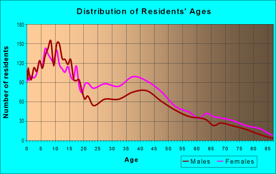
| Males: | 2,346 |
| Females: | 4,379 |
Males:
| This neighborhood: | 48.9 years |
| Whole city: | 35.6 years |
| This neighborhood: | 38.6 years |
| Whole city: | 38.1 years |
Average household size:
| St Clair-Superior: | 2.0 people |
| Cleveland: | 27.0 people |
Percentage of family households:
| St Clair-Superior: | 28.2% |
| Cleveland: | 32.3% |
| Here: | 3.5% |
| Cleveland: | 18.6% |
Percentage of married-couple families with children (among all households):
| St Clair-Superior: | 27.4% |
| Cleveland: | 10.0% |
Percentage of single-mother households (among all households):
| St Clair-Superior: | 51.2% |
| Cleveland: | 30.3% |
Percentage of never married males 15 years old and over:
Percentage of never married females 15 years old and over:
| St Clair-Superior: | 21.4% |
| Cleveland: | 27.7% |
Percentage of never married females 15 years old and over:
| St Clair-Superior: | 42.3% |
| city: | 26.3% |
Percentage of people that speak English not well or not at all:
| St Clair-Superior: | 0.0% |
| Cleveland: | 2.7% |
Percentage of people born in this state:
Percentage of people born in another U.S. state:
Percentage of native residents but born outside the U.S.:
Percentage of foreign born residents:
| Here: | 80.5% |
| Cleveland: | 71.5% |
Percentage of people born in another U.S. state:
| St Clair-Superior: | 14.4% |
| Cleveland: | 17.9% |
Percentage of native residents but born outside the U.S.:
| Here: | 1.3% |
| city: | 4.3% |
Percentage of foreign born residents:
| Here: | 3.9% |
| Cleveland: | 6.3% |

Owner-occupied
Renter-occupied


- Rooms in owner-occupied houses and condos in St Clair-Superior
- 01 room
- 452 rooms
- 03 rooms
- 1754 rooms
- 1,0645 rooms
- 2006 rooms
- 447 rooms
- 2438 rooms
- 3219+ rooms

- Rooms in renter-occupied apartments in St Clair-Superior
- 1,8921 room
- 1,0172 rooms
- 4413 rooms
- 4214 rooms
- 4045 rooms
- 8396 rooms
- 2677 rooms
- 3028 rooms
- 3309+ rooms
Owner-occupied
Renter-occupied

- Bedrooms in owner-occupied houses and condos in St Clair-Superior
- 22no bedroom
- 261 bedroom
- 6642 bedrooms
- 2863 bedrooms
- 5704 bedrooms
- 1,0245+ bedrooms

- Bedrooms in renter-occupied apartments in St Clair-Superior
- 1,892no bedroom
- 4931 bedroom
- 5752 bedrooms
- 8573 bedrooms
- 3044 bedrooms
- 3295+ bedrooms
Average number of cars or other vehicles available in houses/condos:
Average number of cars or other vehicles available in apartments:
| This neighborhood: | |
| Cleveland: |
Average number of cars or other vehicles available in apartments:
| Here: | 0.6 |
| city: | 1.0 |
Percentage of units with a mortgage:
| St Clair-Superior: | 52.5% |
| Cleveland: | 50.7% |

- Year house built in St Clair-Superior
- 02020 or later
- 2072010 to 2019
- 1922000 to 2009
- 3131990 to 1999
- 3121980 to 1989
- 4781970 to 1979
- 3,0721960 to 1969
- 5591950 to 1959
- 5431940 to 1949
- 4,9701939 or earlier

City-data.com crime index for city in 2020 (higher means more crime):
| City: | 735.3 |
| U.S. average: | 219.5 |
Travel time to work (commute)
![Travel time to work (commute)]()
- 90Less than 5 minutes
- 5565 to 9 minutes
- 42710 to 14 minutes
- 30415 to 19 minutes
- 10020 to 24 minutes
- 57025 to 29 minutes
- 65930 to 34 minutes
- 43535 to 39 minutes
- 12640 to 44 minutes
- 32045 to 59 minutes
- 15760 to 89 minutes
- 10790 or more minutes

Means of transportation to work
![Means of transportation to work]()
- 57.9%1,149Drove a car alone
- 45.3%898Carpooled
- 16.8%334Bus
- 41.2%817Walked
- 20.5%407Worked at home

Time leaving home to go to work
![Time leaving home to go to work]()
- 3612:00 a.m. to 4:59 a.m.
- 475:00 a.m. to 5:29 a.m.
- 2146:00 a.m. to 6:29 a.m.
- 3936:30 a.m. to 6:59 a.m.
- 3077:00 a.m. to 7:29 a.m.
- 207:30 a.m. to 7:59 a.m.
- 4778:00 a.m. to 8:29 a.m.
- 128:30 a.m. to 8:59 a.m.
- 729:00 a.m. to 9:59 a.m.
- 14010:00 a.m. to 10:59 a.m.
- 41511:00 a.m. to 11:59 a.m.
- 54912:00 p.m. to 3:59 p.m.
- 2464:00 p.m. to 11:59 p.m.

Occupations of males:
- Percentage of males in architecture and engineering occupations:
Here: 1.0% city: 1.8%
- Percentage of males in community and social services occupations:
Here: 19.4% city: 1.4%
- Percentage of males in service occupations:
Here: 5.7% city: 20.2%
- Percentage of males in construction, extraction, and maintenance occupations:
Here: 61.5% city: 6.7%
- Percentage of males in production occupations:
Here: 7.8% city: 10.8%
- Percentage of males in material moving occupations:
Here: 2.9% city: 9.1%
Occupations of females:
- Percentage of females in management occupations (except farmers):
Here: 8.4% city: 6.9%
- Percentage of females in community and social services occupations:
Here: 6.7% city: 2.8%
- Percentage of females in education, training, and library occupations:
Here: 21.6% city: 5.8%
- Percentage of females in healthcare practitioners and technical occupations:
Here: 10.2% city: 9.3%
- Percentage of females in service occupations:
Here: 41.3% city: 26.3%
- Percentage of females in sales and office occupations:
Here: 11.0% city: 27.0%
Education in this neighborhood (subdivision or community):
- Percentage of people 3 years and older in K-12 schools:
St Clair-Superior: 102.9% Cleveland: 15.5%
- Percentage of people 3 years and older in undergraduate colleges:
St Clair-Superior: 16.8% Cleveland: 5.1%
- Percentage of people 3 years and older in grad. or professional schools:
St Clair-Superior: 5.5% Cleveland: 1.7%
- Percentage of students K-12 enrolled in private schools:
St Clair-Superior: 38.1% Cleveland: 22.4%
Percentage of population below poverty level:
| St Clair-Superior: | 39.4% |
| Cleveland: | 31.8% |
Percentage of married-couple families with both working:
| St Clair-Superior: | 38.8% |
| Cleveland: | 72.0% |

- 45.2%Electricity
- 42.2%Utility gas
- 5.6%Bottled, tank, or LP gas
- 4.7%Other fuel
- 2.4%No fuel used
Limited-access highways (interstate or state) in this neighborhood:
Cleveland Memorial State Hwy (State Rte 2, Lakeland Fwy, I- 90, Northwest Fwy)
Length: 1.17 miles
Directions: E-W, N-S, SW-NE
Directions: E-W, N-S, SW-NE
Highways in this neighborhood:
US Hwy 6 (Superior Ave)
Length: 1.89 miles
Direction: E-W
Address range: 5500 to 9899
Direction: E-W
Address range: 5500 to 9899
Roads and streets:
Saint Clair Ave
Length: 1.11 miles
Directions: E-W, SW-NE
Address range: 5550 to 7499
Directions: E-W, SW-NE
Address range: 5550 to 7499
E 55th St
Length: 0.93 miles
Direction: N-S
Address range: 750 to 1598
Direction: N-S
Address range: 750 to 1598
Addison Rd
Length: 0.88 miles
Directions: N-S, SE-NW
Address range: 800 to 1299
Directions: N-S, SE-NW
Address range: 800 to 1299
E 72nd St
Length: 0.85 miles
Directions: N-S, SE-NW, SW-NE
Address range: 622 to 1199
Directions: N-S, SE-NW, SW-NE
Address range: 622 to 1199
E 70th St
Length: 0.72 miles
Direction: N-S
Address range: 800 to 1060
Direction: N-S
Address range: 800 to 1060
E 67th St
Length: 0.70 miles
Directions: N-S, SE-NW
Address range: 800 to 1299
Directions: N-S, SE-NW
Address range: 800 to 1299
Bonna Ave
Length: 0.68 miles
Directions: E-W, SW-NE
Address range: 5500 to 6899
Directions: E-W, SW-NE
Address range: 5500 to 6899
Dr Martin Luther King Blvd
Length: 0.68 miles
Directions: N-S, SE-NW
Directions: N-S, SE-NW
Ansel Rd
Length: 0.66 miles
Direction: SE-NW
Address range: 984 to 1299
Direction: SE-NW
Address range: 984 to 1299
E 74th St
Length: 0.65 miles
Direction: N-S
Address range: 900 to 1299
Direction: N-S
Address range: 900 to 1299
E 71st St
Length: 0.59 miles
Direction: N-S
Address range: 1000 to 1299
Direction: N-S
Address range: 1000 to 1299
E 61st St
Length: 0.56 miles
Directions: N-S, SE-NW
Address range: 1000 to 1299
Directions: N-S, SE-NW
Address range: 1000 to 1299
Korman Ave
Length: 0.56 miles
Direction: E-W
Address range: 7400 to 8399
Direction: E-W
Address range: 7400 to 8399
E 79th St
Length: 0.50 miles
Direction: N-S
Address range: 1004 to 1299
Direction: N-S
Address range: 1004 to 1299
Kosciuszko Ave
Length: 0.47 miles
Direction: E-W
Address range: 7900 to 8699
Direction: E-W
Address range: 7900 to 8699
E 63rd St
Length: 0.47 miles
Directions: N-S, SE-NW
Address range: 800 to 1199
Directions: N-S, SE-NW
Address range: 800 to 1199
Sowinski Ave
Length: 0.43 miles
Direction: E-W
Address range: 7900 to 8699
Direction: E-W
Address range: 7900 to 8699
Norwood Rd
Length: 0.43 miles
Directions: N-S, SE-NW
Address range: 1100 to 1299
Directions: N-S, SE-NW
Address range: 1100 to 1299
Myron Ave
Length: 0.42 miles
Direction: E-W
Address range: 7100 to 7899
Direction: E-W
Address range: 7100 to 7899
Donald Ave
Length: 0.42 miles
Direction: E-W
Address range: 7100 to 7899
Direction: E-W
Address range: 7100 to 7899
Lockyear Ave
Length: 0.42 miles
Direction: E-W
Address range: 7100 to 7899
Direction: E-W
Address range: 7100 to 7899
Edna Ave
Length: 0.41 miles
Directions: E-W, SW-NE
Address range: 6100 to 6899
Directions: E-W, SW-NE
Address range: 6100 to 6899
East Blvd
Length: 0.41 miles
Directions: E-W, N-S, SE-NW
Address range: 1048 to 1250
Directions: E-W, N-S, SE-NW
Address range: 1048 to 1250
Pulaski Ave
Length: 0.40 miles
Direction: E-W
Address range: 7900 to 8499
Direction: E-W
Address range: 7900 to 8499
E 82nd St
Length: 0.38 miles
Direction: N-S
Address range: 1080 to 1299
Direction: N-S
Address range: 1080 to 1299
Medina Ave
Length: 0.37 miles
Direction: E-W
Address range: 7900 to 8499
Direction: E-W
Address range: 7900 to 8499
E 60th St
Length: 0.36 miles
Directions: N-S, SE-NW
Address range: 1100 to 1299
Directions: N-S, SE-NW
Address range: 1100 to 1299
Bellevue Ave
Length: 0.34 miles
Direction: E-W
Address range: 7900 to 8499
Direction: E-W
Address range: 7900 to 8499
Hecker Ave
Length: 0.33 miles
Direction: E-W
Address range: 6900 to 7399
Direction: E-W
Address range: 6900 to 7399
S Marginal Rd
Length: 0.31 miles
Direction: SW-NE
Address range: 5500 to 6899
Direction: SW-NE
Address range: 5500 to 6899
N Marginal Rd
Length: 0.31 miles
Direction: SW-NE
Address range: 5400 to 6299
Direction: SW-NE
Address range: 5400 to 6299
Glass Ave
Length: 0.30 miles
Direction: SW-NE
Address range: 6000 to 6399
Direction: SW-NE
Address range: 6000 to 6399
E 68th St
Length: 0.28 miles
Direction: SE-NW
Address range: 1000 to 1199
Direction: SE-NW
Address range: 1000 to 1199
E 58th St
Length: 0.27 miles
Directions: N-S, SE-NW
Address range: 1100 to 1299
Directions: N-S, SE-NW
Address range: 1100 to 1299
Simon Ave
Length: 0.26 miles
Direction: E-W
Address range: 7900 to 8299
Direction: E-W
Address range: 7900 to 8299
E 86th St
Length: 0.26 miles
Directions: N-S, SW-NE
Address range: 1000 to 1299
Directions: N-S, SW-NE
Address range: 1000 to 1299
Bliss Ave
Length: 0.26 miles
Directions: E-W, SW-NE
Address range: 6500 to 7099
Directions: E-W, SW-NE
Address range: 6500 to 7099
Cornelia Ave
Length: 0.25 miles
Direction: E-W
Address range: 7400 to 7899
Direction: E-W
Address range: 7400 to 7899
Aberdeen Ave
Length: 0.25 miles
Direction: E-W
Address range: 7400 to 7899
Direction: E-W
Address range: 7400 to 7899
E 64th St
Length: 0.25 miles
Direction: SE-NW
Address range: 900 to 1124
Direction: SE-NW
Address range: 900 to 1124
Bayliss Ave
Length: 0.24 miles
Direction: E-W
Address range: 6700 to 6999
Direction: E-W
Address range: 6700 to 6999
E 80th St
Length: 0.23 miles
Direction: N-S
Address range: 1100 to 1299
Direction: N-S
Address range: 1100 to 1299
E 69th St
Length: 0.23 miles
Directions: N-S, SE-NW
Address range: 900 to 1099
Directions: N-S, SE-NW
Address range: 900 to 1099
E 77th St
Length: 0.23 miles
Direction: N-S
Address range: 1050 to 1199
Direction: N-S
Address range: 1050 to 1199
E 76th St
Length: 0.23 miles
Direction: N-S
Address range: 1050 to 1199
Direction: N-S
Address range: 1050 to 1199
E 78th St
Length: 0.23 miles
Direction: N-S
Address range: 1051 to 1327
Direction: N-S
Address range: 1051 to 1327
E 81st St
Length: 0.23 miles
Direction: N-S
Address range: 1100 to 1299
Direction: N-S
Address range: 1100 to 1299
Carl Ave
Length: 0.22 miles
Direction: E-W
Address range: 6200 to 6499
Direction: E-W
Address range: 6200 to 6499
Schaefer Ave
Length: 0.22 miles
Directions: E-W, SW-NE
Address range: 6500 to 7099
Directions: E-W, SW-NE
Address range: 6500 to 7099
E 84th St
Length: 0.21 miles
Direction: N-S
Address range: 1100 to 1299
Direction: N-S
Address range: 1100 to 1299
Prosser Ave
Length: 0.21 miles
Direction: E-W
Address range: 5500 to 5999
Direction: E-W
Address range: 5500 to 5999
E 85th St
Length: 0.21 miles
Direction: N-S
Address range: 1100 to 1299
Direction: N-S
Address range: 1100 to 1299
E 87th St
Length: 0.19 miles
Direction: N-S
Address range: 1100 to 1268
Direction: N-S
Address range: 1100 to 1268
E 66th St
Length: 0.19 miles
Direction: SE-NW
Address range: 1000 to 1199
Direction: SE-NW
Address range: 1000 to 1199
E 83rd St
Length: 0.19 miles
Direction: N-S
Address range: 1100 to 1299
Direction: N-S
Address range: 1100 to 1299
E 99th St
Length: 0.18 miles
Direction: N-S
Address range: 1131 to 1229
Direction: N-S
Address range: 1131 to 1229
Luther Ave
Length: 0.18 miles
Direction: E-W
Address range: 5500 to 5999
Direction: E-W
Address range: 5500 to 5999
E 62nd St
Length: 0.17 miles
Direction: SE-NW
Address range: 1000 to 1099
Direction: SE-NW
Address range: 1000 to 1099
E 98th St
Length: 0.17 miles
Directions: N-S, SW-NE
Address range: 1101 to 1183
Directions: N-S, SW-NE
Address range: 1101 to 1183
E 69th Pl
Length: 0.17 miles
Direction: N-S
Address range: 900 to 999
Direction: N-S
Address range: 900 to 999
Machinery Ave
Length: 0.16 miles
Directions: E-W, SE-NW
Address range: 6700 to 6999
Directions: E-W, SE-NW
Address range: 6700 to 6999
E 72nd Pl
Length: 0.16 miles
Direction: N-S
Address range: 900 to 1299
Direction: N-S
Address range: 900 to 1299
Artic Ct
Length: 0.15 miles
Direction: E-W
Address range: 6700 to 6899
Direction: E-W
Address range: 6700 to 6899
Carry Ave
Length: 0.15 miles
Directions: E-W, SW-NE
Address range: 5500 to 6099
Directions: E-W, SW-NE
Address range: 5500 to 6099
North Blvd
Length: 0.15 miles
Direction: E-W
Address range: 9700 to 9899
Direction: E-W
Address range: 9700 to 9899
E 59th St
Length: 0.13 miles
Direction: N-S
Address range: 1200 to 1299
Direction: N-S
Address range: 1200 to 1299
Shakespeare Pkwy
Length: 0.13 miles
Direction: E-W
Address range: 9500 to 9699
Direction: E-W
Address range: 9500 to 9699
Thorn Ave
Length: 0.11 miles
Direction: E-W
Address range: 9600 to 9699
Direction: E-W
Address range: 9600 to 9699
Parkside Rd
Length: 0.11 miles
Directions: N-S, SE-NW
Address range: 1072 to 1199
Directions: N-S, SE-NW
Address range: 1072 to 1199
Spilker Ave
Length: 0.11 miles
Directions: E-W, N-S, SW-NE
Address range: 6400 to 6499
Directions: E-W, N-S, SW-NE
Address range: 6400 to 6499
Westchester Ave
Length: 0.11 miles
Direction: E-W
Address range: 9750 to 9899
Direction: E-W
Address range: 9750 to 9899
Schade Ave
Length: 0.11 miles
Direction: E-W
Address range: 6100 to 6399
Direction: E-W
Address range: 6100 to 6399
E 98th Pl
Length: 0.10 miles
Directions: N-S, SE-NW
Address range: 1120 to 1157
Directions: N-S, SE-NW
Address range: 1120 to 1157
E 97th St
Length: 0.09 miles
Direction: N-S
Address range: 1070 to 1169
Direction: N-S
Address range: 1070 to 1169
Metta Ave
Length: 0.09 miles
Direction: E-W
Address range: 6500 to 6699
Direction: E-W
Address range: 6500 to 6699
Dallas Rd
Length: 0.09 miles
Direction: SE-NW
Address range: 1100 to 1199
Direction: SE-NW
Address range: 1100 to 1199
Becker Ct
Length: 0.09 miles
Directions: E-W, SW-NE
Address range: 6900 to 7099
Directions: E-W, SW-NE
Address range: 6900 to 7099
Varian Ave
Length: 0.08 miles
Directions: E-W, SW-NE
Address range: 6400 to 6499
Directions: E-W, SW-NE
Address range: 6400 to 6499
Grdina Ave
Length: 0.08 miles
Directions: E-W, SW-NE
Address range: 6100 to 6199
Directions: E-W, SW-NE
Address range: 6100 to 6199
Juniata Ave
Length: 0.08 miles
Direction: E-W
Address range: 6500 to 6599
Direction: E-W
Address range: 6500 to 6599
Olivet Ave
Length: 0.08 miles
Direction: E-W
Address range: 9800 to 9899
Direction: E-W
Address range: 9800 to 9899
E 66th Pl
Length: 0.08 miles
Direction: N-S
Address range: 900 to 1099
Direction: N-S
Address range: 900 to 1099
South Blvd
Length: 0.08 miles
Direction: E-W
Address range: 9800 to 9899
Direction: E-W
Address range: 9800 to 9899
E 99th Pl
Length: 0.07 miles
Direction: N-S
Address range: 1050 to 1299
Direction: N-S
Address range: 1050 to 1299
Hedwig Ct
Length: 0.07 miles
Direction: E-W
Address range: 8200 to 8699
Direction: E-W
Address range: 8200 to 8699
Fancher Ave
Length: 0.07 miles
Direction: E-W
Address range: 8100 to 8299
Direction: E-W
Address range: 8100 to 8299
Dryden Ave
Length: 0.07 miles
Direction: SW-NE
Address range: 8650 to 8749
Direction: SW-NE
Address range: 8650 to 8749
Peck Ave
Length: 0.07 miles
Direction: E-W
Address range: 6900 to 7099
Direction: E-W
Address range: 6900 to 7099
Derby Ave
Length: 0.06 miles
Direction: SW-NE
Address range: 8650 to 8749
Direction: SW-NE
Address range: 8650 to 8749
Orton Ct
Length: 0.06 miles
Direction: SW-NE
Address range: 6300 to 6499
Direction: SW-NE
Address range: 6300 to 6499
E 73rd Pl
Length: 0.06 miles
Direction: N-S
Address range: 1200 to 1299
Direction: N-S
Address range: 1200 to 1299
Constance Ct
Length: 0.04 miles
Direction: E-W
Address range: 7100 to 7199
Direction: E-W
Address range: 7100 to 7199
Railroad features:
Csx RR (Penn Central RR)
Length: 1.51 miles
Directions: E-W, N-S, SW-NE
Directions: E-W, N-S, SW-NE
Penn Central RR
Length: 0.29 miles
Directions: E-W, SW-NE
Directions: E-W, SW-NE
Other features:
Doan Brk
Length: 0.10 miles
Directions: E-W, SE-NW
Directions: E-W, SE-NW