St. Anthony neighborhood in Saint Paul, Minnesota (MN), 55108, 55114 detailed profile
Settings
X


Area: 2.434 square miles
Population: 6,830
Population density: 2,806 people per square mile

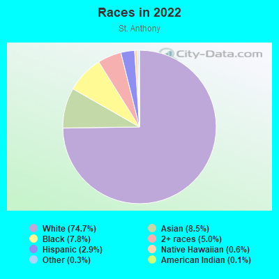
- 5,29574.7%White
- 6028.5%Asian
- 5517.8%Black
- 3575.0%Two or more races
- 2052.9%Hispanic or Latino
- 460.6%Native Hawaiian and Other
Pacific Islander - 230.3%Some other race
- 80.1%American Indian
Median household income in 2022:
| St. Anthony: | $84,750 |
| Minnesota: | $82,338 |
Distribution of median household income
![Distribution of median household income]()
- 173Less than $10,000
- 205$10,000 to $19,999
- 203$20,000 to $29,999
- 321$30,000 to $39,999
- 322$40,000 to $49,999
- 311$50,000 to $59,999
- 309$60,000 to $74,999
- 399$75,000 to $99,999
- 344$100,000 to $124,999
- 252$125,000 to $149,999
- 312$150,000 to $199,999
- 377$200,000 or more

Distribution of owner-occupied house/condo value
![Distribution of owner-occupied house/condo value]()
- 341Less than $50,000
- 849$100,000 to $149,999
- 220$150,000 to $199,999
- 243$200,000 to $249,999
- 220$250,000 to $299,999
- 455$300,000 to $399,999
- 696$400,000 to $499,999
- 390$500,000 to $749,999
- 414$750,000 to $999,999
- 121$1,000,000 or more

Distribution of rent paid by renters
![Distribution of rent paid by renters]()
- 20Less than $100
- 41$100 to $199
- 81$200 to $299
- 79$300 to $399
- 175$400 to $499
- 149$500 to $599
- 73$600 to $699
- 283$700 to $799
- 143$800 to $899
- 109$900 to $999
- 478$1,000 to $1,249
- 221$1,250 to $1,499
- 260$1,500 to $1,999
- 566$2,000 or more

Median rent in 2022:
| St. Anthony: | $1,241 |
| Minnesota: | $1,087 |
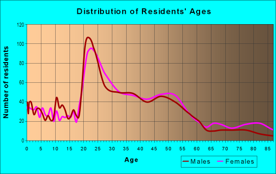
| Males: | 3,439 |
| Females: | 3,391 |
| Males: | 32.2 years |
| Females: | 34.3 years |
Average household size:
| St. Anthony: | 2.0 people |
| Minnesota: | 2.4 people |
Percentage of family households:
| St. Anthony: | 36.0% |
| Minnesota: | 45.6% |
| Here: | 39.1% |
| Minnesota: | 49.4% |
Percentage of married-couple families with children (among all households):
| St. Anthony: | 36.6% |
| Minnesota: | 53.9% |
Percentage of single-mother households (among all households):
| St. Anthony: | 5.4% |
| Minnesota: | 7.1% |
Percentage of never married males 15 years old and over:
Percentage of never married females 15 years old and over:
| St. Anthony: | 26.1% |
| Minnesota: | 17.9% |
Percentage of never married females 15 years old and over:
| St. Anthony: | 22.2% |
| Minnesota: | 15.2% |
Percentage of people that speak English not well or not at all:
| St. Anthony: | 1.2% |
| Minnesota: | 2.1% |
Percentage of people born in this state:
Percentage of people born in another U.S. state:
Percentage of native residents but born outside the U.S.:
Percentage of foreign born residents:
| Here: | 53.1% |
| Minnesota: | 67.2% |
Percentage of people born in another U.S. state:
| St. Anthony: | 32.4% |
| Minnesota: | 23.2% |
Percentage of native residents but born outside the U.S.:
| Here: | 1.0% |
| Minnesota: | 0.9% |
Percentage of foreign born residents:
| Here: | 13.5% |
| Minnesota: | 8.7% |
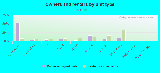
Owner-occupied
Renter-occupied

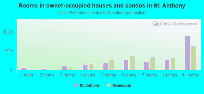
- Rooms in owner-occupied houses and condos in St. Anthony
- 641 room
- 452 rooms
- 963 rooms
- 1474 rooms
- 1875 rooms
- 2736 rooms
- 2227 rooms
- 2638 rooms
- 8899+ rooms
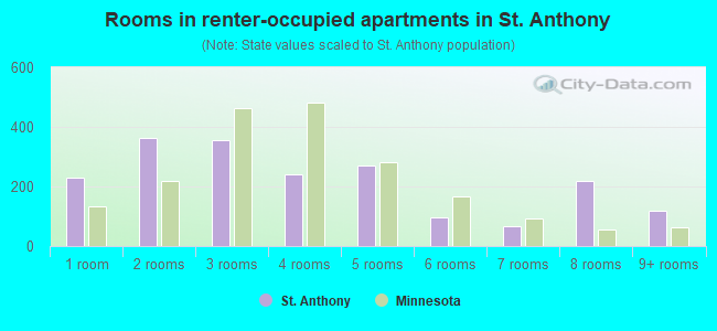
- Rooms in renter-occupied apartments in St. Anthony
- 2291 room
- 3642 rooms
- 3563 rooms
- 2404 rooms
- 2715 rooms
- 966 rooms
- 677 rooms
- 2188 rooms
- 1199+ rooms
Owner-occupied
Renter-occupied
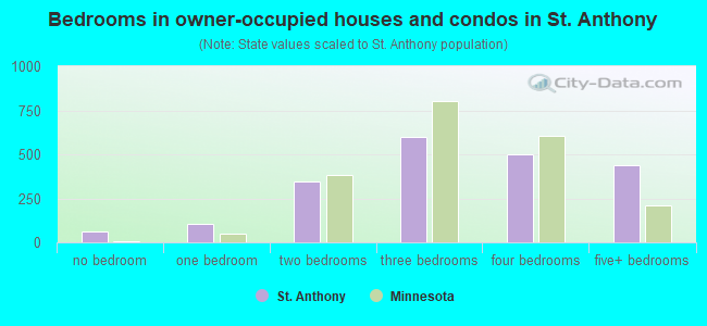
- Bedrooms in owner-occupied houses and condos in St. Anthony
- 64no bedroom
- 1081 bedroom
- 3452 bedrooms
- 5993 bedrooms
- 5034 bedrooms
- 4365+ bedrooms
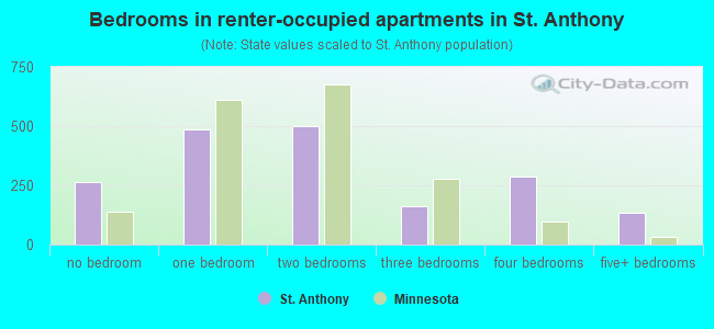
- Bedrooms in renter-occupied apartments in St. Anthony
- 266no bedroom
- 4841 bedroom
- 5002 bedrooms
- 1613 bedrooms
- 2894 bedrooms
- 1325+ bedrooms
Average number of cars or other vehicles available in houses/condos:
Average number of cars or other vehicles available in apartments:
| This neighborhood: | |
| Minnesota: |
Average number of cars or other vehicles available in apartments:
| Here: | 1.2 |
| Minnesota: | 1.3 |
Percentage of units with a mortgage:
| St. Anthony: | 63.7% |
| Minnesota: | 64.3% |
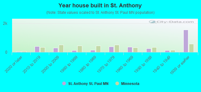
- Year house built in St. Anthony
- 332020 or later
- 4042010 to 2019
- 2972000 to 2009
- 1321990 to 1999
- 1571980 to 1989
- 3761970 to 1979
- 3521960 to 1969
- 2561950 to 1959
- 1281940 to 1949
- 1,5481939 or earlier
Travel time to work (commute)
![Travel time to work (commute)]()
- 131Less than 5 minutes
- 2715 to 9 minutes
- 67410 to 14 minutes
- 61215 to 19 minutes
- 85620 to 24 minutes
- 21025 to 29 minutes
- 43630 to 34 minutes
- 5035 to 39 minutes
- 2640 to 44 minutes
- 20945 to 59 minutes
- 4160 to 89 minutes
- 24790 or more minutes

Means of transportation to work
![Means of transportation to work]()
- 55.9%2,219Drove a car alone
- 4.8%190Carpooled
- 8.4%335Bus
- 1.0%38Subway or elevated rail
- 1.5%60Long-distance train or commuter rail
- 4.1%164Light rail, streetcar or trolley
- 2.1%85Taxi
- 4.5%178Motorcycle
- 2.2%89Bicycle
- 8.5%339Walked
- 1.7%66Other means
- 18.1%720Worked at home

Time leaving home to go to work
![Time leaving home to go to work]()
- 5512:00 a.m. to 4:59 a.m.
- 615:00 a.m. to 5:29 a.m.
- 1595:30 a.m. to 5:59 a.m.
- 1026:00 a.m. to 6:29 a.m.
- 2796:30 a.m. to 6:59 a.m.
- 4457:00 a.m. to 7:29 a.m.
- 6187:30 a.m. to 7:59 a.m.
- 4268:00 a.m. to 8:29 a.m.
- 3138:30 a.m. to 8:59 a.m.
- 3099:00 a.m. to 9:59 a.m.
- 19610:00 a.m. to 10:59 a.m.
- 9011:00 a.m. to 11:59 a.m.
- 25212:00 p.m. to 3:59 p.m.
- 2124:00 p.m. to 11:59 p.m.

Occupations of males:
- Percentage of males in management occupations (except farmers):
Here: 12.6% Minnesota: 13.1%
- Percentage of males in business and financial operations occupations:
Here: 5.7% Minnesota: 5.7%
- Percentage of males in computer and mathematical occupations:
Here: 6.9% Minnesota: 5.4%
- Percentage of males in architecture and engineering occupations:
Here: 3.2% Minnesota: 3.8%
- Percentage of males in life, physical, and social science occupations:
Here: 7.4% Minnesota: 1.2%
- Percentage of males in legal occupations:
Here: 1.2% Minnesota: 0.9%
- Percentage of males in education, training, and library occupations:
Here: 14.2% Minnesota: 3.2%
- Percentage of males in arts, design, entertainment, sports, and media occupations:
Here: 4.7% Minnesota: 1.8%
- Percentage of males in healthcare practitioners and technical occupations:
Here: 5.5% Minnesota: 2.9%
- Percentage of males in service occupations:
Here: 8.0% Minnesota: 11.5%
- Percentage of males in sales and office occupations:
Here: 16.3% Minnesota: 15.0%
- Percentage of males in construction, extraction, and maintenance occupations:
Here: 1.3% Minnesota: 8.1%
- Percentage of males in production occupations:
Here: 3.7% Minnesota: 9.3%
- Percentage of males in material moving occupations:
Here: 2.8% Minnesota: 4.8%
Occupations of females:
- Percentage of females in management occupations (except farmers):
Here: 10.9% Minnesota: 9.8%
- Percentage of females in business and financial operations occupations:
Here: 1.8% Minnesota: 7.7%
- Percentage of females in computer and mathematical occupations:
Here: 1.8% Minnesota: 2.1%
- Percentage of females in architecture and engineering occupations:
Here: 1.9% Minnesota: 0.8%
- Percentage of females in life, physical, and social science occupations:
Here: 5.6% Minnesota: 1.2%
- Percentage of females in community and social services occupations:
Here: 3.6% Minnesota: 2.9%
- Percentage of females in legal occupations:
Here: 2.3% Minnesota: 1.2%
- Percentage of females in education, training, and library occupations:
Here: 17.4% Minnesota: 9.5%
- Percentage of females in arts, design, entertainment, sports, and media occupations:
Here: 5.0% Minnesota: 2.4%
- Percentage of females in healthcare practitioners and technical occupations:
Here: 16.0% Minnesota: 11.0%
- Percentage of females in service occupations:
Here: 14.6% Minnesota: 19.2%
- Percentage of females in sales and office occupations:
Here: 17.5% Minnesota: 24.4%
Percentage of people 16-64 in Armed Forces:
| St. Anthony: | 0.1% |
| Minnesota: | 0.1% |
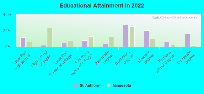
Education in this neighborhood (subdivision or community):
- Percentage of people 3 years and older in K-12 schools:
St. Anthony: 26.1% Minnesota: 17.3%
- Percentage of people 3 years and older in undergraduate colleges:
St. Anthony: 12.9% Minnesota: 4.5%
- Percentage of people 3 years and older in grad. or professional schools:
St. Anthony: 12.1% Minnesota: 1.3%
- Percentage of students K-12 enrolled in private schools:
St. Anthony: 27.3% Minnesota: 11.8%
Percentage of population below poverty level:
| St. Anthony: | 12.8% |
| Minnesota: | 9.6% |
Median year renter moved in (as recorded in 2022):
| St. Anthony: | 2016 |
| Minnesota: | 2020 |
Percentage of married-couple families with both working:
| St. Anthony: | 133.8% |
| Minnesota: | 81.3% |
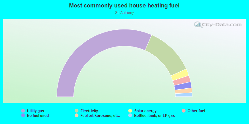
- 63.2%Utility gas
- 23.3%Electricity
- 3.3%Solar energy
- 3.1%Other fuel
- 2.9%No fuel used
- 2.3%Fuel oil, kerosene, etc.
- 1.9%Bottled, tank, or LP gas
Limited-access highways (interstate or state) in this neighborhood:
US Hwy 12 (I- 94)
Length: 0.37 miles
Directions: E-W, SE-NW
Directions: E-W, SE-NW
Highways in this neighborhood:
University Ave (US Hwy 52, University Ave W)
Length: 1.41 miles
Direction: E-W
Address range: 2100 to 2745
Direction: E-W
Address range: 2100 to 2745
State Hwy 51 (Snelling Ave)
Length: 0.14 miles
Direction: N-S
Address range: 951 to 1036
Direction: N-S
Address range: 951 to 1036
Roads and streets:
State Hwy 280
Length: 3.68 miles
Directions: N-S, SW-NE
Directions: N-S, SW-NE
Energy Park Dr
Length: 2.54 miles
Directions: E-W, SE-NW
Address range: 1562 to 2499
Directions: E-W, SE-NW
Address range: 1562 to 2499
Como Ave
Length: 2.03 miles
Directions: E-W, N-S, SE-NW
Address range: 1784 to 2511
Directions: E-W, N-S, SE-NW
Address range: 1784 to 2511
Raymond Ave
Length: 1.86 miles
Directions: N-S, SW-NE
Address range: 600 to 1522
Directions: N-S, SW-NE
Address range: 600 to 1522
N Eustis St
Length: 1.46 miles
Directions: N-S, SE-NW, SW-NE
Address range: 661 to 1547
Directions: N-S, SE-NW, SW-NE
Address range: 661 to 1547
Commonwealth Ave
Length: 1.21 miles
Directions: E-W, N-S, SW-NE
Address range: 2044 to 2499
Directions: E-W, N-S, SW-NE
Address range: 2044 to 2499
Wabash Ave
Length: 1.20 miles
Direction: E-W
Address range: 2001 to 2461
Direction: E-W
Address range: 2001 to 2461
W Doswell Ave
Length: 1.20 miles
Directions: E-W, SW-NE
Address range: 2000 to 2600
Directions: E-W, SW-NE
Address range: 2000 to 2600
Carter Ave
Length: 1.11 miles
Directions: E-W, SW-NE
Address range: 2050 to 2499
Directions: E-W, SW-NE
Address range: 2050 to 2499
N Cleveland Ave
Length: 1.09 miles
Directions: E-W, N-S, SW-NE
Address range: 470 to 1558
Directions: E-W, N-S, SW-NE
Address range: 470 to 1558
Myrtle Ave
Length: 1.01 miles
Direction: E-W
Address range: 2100 to 2500
Direction: E-W
Address range: 2100 to 2500
Cromwell Ave
Length: 0.95 miles
Directions: E-W, N-S, SE-NW, SW-NE
Address range: 600 to 1100
Directions: E-W, N-S, SE-NW, SW-NE
Address range: 600 to 1100
W Hendon Ave
Length: 0.93 miles
Direction: E-W
Address range: 2050 to 2399
Direction: E-W
Address range: 2050 to 2399
Charles Ave
Length: 0.78 miles
Directions: E-W, SE-NW
Address range: 2100 to 2667
Directions: E-W, SE-NW
Address range: 2100 to 2667
Vandalia St
Length: 0.76 miles
Directions: N-S, SW-NE
Address range: 596 to 999
Directions: N-S, SW-NE
Address range: 596 to 999
W Buford Ave
Length: 0.72 miles
Directions: E-W, SE-NW
Address range: 2077 to 2400
Directions: E-W, SE-NW
Address range: 2077 to 2400
Capp Rd
Length: 0.69 miles
Directions: E-W, N-S, SE-NW, SW-NE
Address range: 2000 to 2499
Directions: E-W, N-S, SE-NW, SW-NE
Address range: 2000 to 2499
W Hillside Ave
Length: 0.69 miles
Directions: E-W, SE-NW, SW-NE
Address range: 2200 to 2499
Directions: E-W, SE-NW, SW-NE
Address range: 2200 to 2499
Knapp St
Length: 0.68 miles
Directions: E-W, SW-NE
Address range: 2060 to 2299
Directions: E-W, SW-NE
Address range: 2060 to 2299
Gordon Ave
Length: 0.67 miles
Directions: E-W, N-S, SE-NW, SW-NE
Address range: 2100 to 2399
Directions: E-W, N-S, SE-NW, SW-NE
Address range: 2100 to 2399
Territorial Rd
Length: 0.67 miles
Directions: E-W, SE-NW
Address range: 2380 to 2665
Directions: E-W, SE-NW
Address range: 2380 to 2665
N Hunting Valley Rd
Length: 0.64 miles
Directions: N-S, SE-NW, SW-NE
Address range: 1200 to 1499
Directions: N-S, SE-NW, SW-NE
Address range: 1200 to 1499
W Hampden Ave
Length: 0.61 miles
Directions: E-W, N-S, SE-NW, SW-NE
Address range: 900 to 2399
Directions: E-W, N-S, SE-NW, SW-NE
Address range: 900 to 2399
W Territorial Rd
Length: 0.60 miles
Direction: E-W
Address range: 2200 to 2387
Direction: E-W
Address range: 2200 to 2387
Langford Park
Length: 0.56 miles
Directions: E-W, N-S, SE-NW, SW-NE
Address range: 1 to 199
Directions: E-W, N-S, SE-NW, SW-NE
Address range: 1 to 199
Scudder St
Length: 0.54 miles
Directions: E-W, N-S, SW-NE
Address range: 2000 to 2300
Directions: E-W, N-S, SW-NE
Address range: 2000 to 2300
Brewster St
Length: 0.50 miles
Directions: E-W, SE-NW
Address range: 1900 to 2399
Directions: E-W, SE-NW
Address range: 1900 to 2399
Franklin Ave
Length: 0.50 miles
Direction: E-W
Address range: 2400 to 2551
Direction: E-W
Address range: 2400 to 2551
Big Oak Rd
Length: 0.49 miles
Directions: N-S, SE-NW
Address range: 714 to 1000
Directions: N-S, SE-NW
Address range: 714 to 1000
N Chelmsford St
Length: 0.48 miles
Directions: N-S, SE-NW
Address range: 1200 to 1526
Directions: N-S, SE-NW
Address range: 1200 to 1526
N Hampden Ave
Length: 0.48 miles
Directions: N-S, SW-NE
Address range: 601 to 899
Directions: N-S, SW-NE
Address range: 601 to 899
W Dudley Ave
Length: 0.48 miles
Direction: E-W
Address range: 2000 to 2299
Direction: E-W
Address range: 2000 to 2299
Curfew St
Length: 0.42 miles
Directions: N-S, SW-NE
Address range: 700 to 900
Directions: N-S, SW-NE
Address range: 700 to 900
Robbins St
Length: 0.42 miles
Directions: E-W, SW-NE
Address range: 2100 to 2400
Directions: E-W, SW-NE
Address range: 2100 to 2400
Kasota Ave
Length: 0.42 miles
Directions: E-W, SE-NW
Address range: 2221 to 2599
Directions: E-W, SE-NW
Address range: 2221 to 2599
Manvel St
Length: 0.41 miles
Directions: E-W, N-S, SE-NW, SW-NE
Address range: 900 to 1100
Directions: E-W, N-S, SE-NW, SW-NE
Address range: 900 to 1100
Ellis Ave
Length: 0.40 miles
Direction: E-W
Address range: 2050 to 2551
Direction: E-W
Address range: 2050 to 2551
W Valentine Ave
Length: 0.39 miles
Direction: E-W
Address range: 2200 to 2500
Direction: E-W
Address range: 2200 to 2500
Berry St
Length: 0.37 miles
Directions: E-W, N-S
Address range: 700 to 939
Directions: E-W, N-S
Address range: 700 to 939
Pelham Blvd
Length: 0.37 miles
Direction: N-S
Address range: 636 to 799
Direction: N-S
Address range: 636 to 799
Bayless Ave
Length: 0.37 miles
Directions: E-W, N-S, SE-NW, SW-NE
Address range: 900 to 1100
Directions: E-W, N-S, SE-NW, SW-NE
Address range: 900 to 1100
N Brompton St
Length: 0.36 miles
Direction: N-S
Address range: 1300 to 1500
Direction: N-S
Address range: 1300 to 1500
N Grantham St
Length: 0.35 miles
Directions: N-S, SE-NW
Address range: 1300 to 1524
Directions: N-S, SE-NW
Address range: 1300 to 1524
Keston St
Length: 0.34 miles
Directions: N-S, SE-NW
Address range: 1200 to 1406
Directions: N-S, SE-NW
Address range: 1200 to 1406
Pearl St
Length: 0.32 miles
Direction: E-W
Address range: 2300 to 2419
Direction: E-W
Address range: 2300 to 2419
N Hythe St
Length: 0.31 miles
Directions: N-S, SW-NE
Address range: 1300 to 1527
Directions: N-S, SW-NE
Address range: 1300 to 1527
Wycliff St
Length: 0.30 miles
Directions: N-S, SE-NW
Address range: 2200 to 2498
Directions: N-S, SE-NW
Address range: 2200 to 2498
W Bourne Ave
Length: 0.29 miles
Direction: E-W
Address range: 2300 to 2499
Direction: E-W
Address range: 2300 to 2499
Bradford St
Length: 0.29 miles
Direction: SW-NE
Address range: 801 to 1000
Direction: SW-NE
Address range: 801 to 1000
Long Ave
Length: 0.28 miles
Directions: E-W, SE-NW
Address range: 2200 to 2400
Directions: E-W, SE-NW
Address range: 2200 to 2400
W Chilcombe Ave
Length: 0.26 miles
Direction: E-W
Address range: 2300 to 2500
Direction: E-W
Address range: 2300 to 2500
Hersey St
Length: 0.25 miles
Directions: N-S, SW-NE
Address range: 801 to 999
Directions: N-S, SW-NE
Address range: 801 to 999
Raleigh St
Length: 0.24 miles
Directions: E-W, SW-NE
Address range: 1100 to 1299
Directions: E-W, SW-NE
Address range: 1100 to 1299
Westgate Dr
Length: 0.24 miles
Directions: E-W, N-S
Address range: 900 to 1099
Directions: E-W, N-S
Address range: 900 to 1099
Bayless Pl
Length: 0.23 miles
Direction: E-W
Address range: 2200 to 2400
Direction: E-W
Address range: 2200 to 2400
Carlton St
Length: 0.22 miles
Direction: SW-NE
Address range: 700 to 899
Direction: SW-NE
Address range: 700 to 899
Vincent St
Length: 0.21 miles
Directions: N-S, SE-NW
Address range: 1401 to 1499
Directions: N-S, SE-NW
Address range: 1401 to 1499
Lasalle St
Length: 0.21 miles
Direction: SW-NE
Address range: 600 to 799
Direction: SW-NE
Address range: 600 to 799
Blake Ave
Length: 0.20 miles
Directions: E-W, SE-NW
Address range: 2200 to 2300
Directions: E-W, SE-NW
Address range: 2200 to 2300
Gilbert Ave
Length: 0.20 miles
Direction: E-W
Address range: 2081 to 2200
Direction: E-W
Address range: 2081 to 2200
Gibbs Ave
Length: 0.19 miles
Direction: SW-NE
Address range: 1000 to 1185
Direction: SW-NE
Address range: 1000 to 1185
W Pricilla St
Length: 0.18 miles
Direction: SE-NW
Address range: 2200 to 2400
Direction: SE-NW
Address range: 2200 to 2400
Montgomery St
Length: 0.17 miles
Direction: SW-NE
Address range: 500 to 799
Direction: SW-NE
Address range: 500 to 799
Cretin Ave N
Length: 0.17 miles
Directions: N-S, SW-NE
Address range: 500 to 595
Directions: N-S, SW-NE
Address range: 500 to 595
Pillsbury St
Length: 0.17 miles
Direction: SW-NE
Address range: 601 to 700
Direction: SW-NE
Address range: 601 to 700
W Luther Pl
Length: 0.17 miles
Directions: N-S, SW-NE
Address range: 2200 to 2300
Directions: N-S, SW-NE
Address range: 2200 to 2300
Branston St
Length: 0.17 miles
Directions: N-S, SE-NW, SW-NE
Address range: 1400 to 1599
Directions: N-S, SE-NW, SW-NE
Address range: 1400 to 1599
Cathlin St
Length: 0.16 miles
Directions: N-S, SE-NW
Address range: 1100 to 1199
Directions: N-S, SE-NW
Address range: 1100 to 1199
Snelling Ave N (Energy Park Dr)
Length: 0.15 miles
Directions: N-S, SW-NE
Directions: N-S, SW-NE
N Stella St
Length: 0.12 miles
Direction: SW-NE
Address range: 1101 to 1200
Direction: SW-NE
Address range: 1101 to 1200
Glendale St
Length: 0.12 miles
Direction: N-S
Address range: 600 to 800
Direction: N-S
Address range: 600 to 800
Windsor Ln
Length: 0.12 miles
Direction: N-S
Direction: N-S
Gordon Pl
Length: 0.11 miles
Direction: E-W
Address range: 2300 to 2400
Direction: E-W
Address range: 2300 to 2400
Fifield Ave
Length: 0.10 miles
Direction: SW-NE
Address range: 1000 to 1099
Direction: SW-NE
Address range: 1000 to 1099
N Knapp Pl
Length: 0.10 miles
Directions: N-S, SE-NW
Address range: 1201 to 1299
Directions: N-S, SE-NW
Address range: 1201 to 1299
W Standish St
Length: 0.10 miles
Direction: SE-NW
Address range: 2280 to 2399
Direction: SE-NW
Address range: 2280 to 2399
Fulham St
Length: 0.09 miles
Direction: N-S
Address range: 1400 to 1499
Direction: N-S
Address range: 1400 to 1499
Ludlow Ave
Length: 0.09 miles
Direction: SW-NE
Address range: 1 to 100
Direction: SW-NE
Address range: 1 to 100
Seal St
Length: 0.09 miles
Direction: N-S
Address range: 800 to 900
Direction: N-S
Address range: 800 to 900
Endicott St
Length: 0.09 miles
Direction: SE-NW
Address range: 2200 to 2399
Direction: SE-NW
Address range: 2200 to 2399
Tainter Ave
Length: 0.09 miles
Direction: SE-NW
Direction: SE-NW
Chelmsford St
Length: 0.08 miles
Direction: SE-NW
Direction: SE-NW
Hunt Pl
Length: 0.08 miles
Direction: SW-NE
Address range: 800 to 999
Direction: SW-NE
Address range: 800 to 999
Everett Ct
Length: 0.08 miles
Direction: N-S
Address range: 1000 to 1099
Direction: N-S
Address range: 1000 to 1099
N Keston St
Length: 0.07 miles
Direction: N-S
Address range: 1407 to 1500
Direction: N-S
Address range: 1407 to 1500
Raymond Pl W
Length: 0.07 miles
Directions: E-W, N-S, SE-NW
Address range: 1 to 71
Directions: E-W, N-S, SE-NW
Address range: 1 to 71
Ray Pl
Length: 0.07 miles
Direction: SW-NE
Address range: 1100 to 1199
Direction: SW-NE
Address range: 1100 to 1199
N Gove Pl
Length: 0.07 miles
Directions: N-S, SW-NE
Address range: 1401 to 1500
Directions: N-S, SW-NE
Address range: 1401 to 1500
Davis St
Length: 0.07 miles
Direction: SW-NE
Direction: SW-NE
Raymond Ln
Length: 0.06 miles
Direction: SW-NE
Address range: 900 to 999
Direction: SW-NE
Address range: 900 to 999
Atty St
Length: 0.06 miles
Direction: SE-NW
Address range: 1 to 100
Direction: SE-NW
Address range: 1 to 100
Grantham St
Length: 0.05 miles
Directions: N-S, SE-NW, SW-NE
Directions: N-S, SE-NW, SW-NE
Railway Pl
Length: 0.04 miles
Directions: N-S, SE-NW
Directions: N-S, SE-NW
Raymond Pl
Length: 0.03 miles
Direction: E-W
Address range: 2 to 99
Direction: E-W
Address range: 2 to 99
Hendon Ave
Length: 0.02 miles
Direction: E-W
Direction: E-W
N Hillside Ct
Length: 0.02 miles
Direction: SW-NE
Address range: 1 to 99
Direction: SW-NE
Address range: 1 to 99
Railroad features:
Burlington Northern Santa Fe Rlwy
Length: 8.98 miles
Directions: E-W, N-S, SE-NW, SW-NE
Directions: E-W, N-S, SE-NW, SW-NE
Canadian Pacific Rlwy
Length: 3.33 miles
Directions: E-W, N-S, SE-NW, SW-NE
Directions: E-W, N-S, SE-NW, SW-NE