Stelton neighborhood in Edison, New Jersey (NJ), 08817, 08904 detailed profile
Settings
X


Business Search - 14 Million verified businesses
Area: 0.881 square miles
Population: 4,944
Population density:
| Stelton: | 5,615 people per square mile |
| Edison: | 3,243 people per square mile |

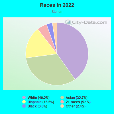
- 2,14840.2%White
- 1,74832.7%Asian
- 89016.6%Hispanic or Latino
- 2715.1%Two or more races
- 1613.0%Black
- 1312.4%Some other race
Median household income in 2022:
| Stelton: | $119,754 |
| New Jersey: | $96,346 |
Distribution of median household income
![Distribution of median household income]()
- 93Less than $10,000
- 487$10,000 to $19,999
- 136$20,000 to $29,999
- 163$30,000 to $39,999
- 164$40,000 to $49,999
- 81$50,000 to $59,999
- 94$60,000 to $74,999
- 262$75,000 to $99,999
- 213$100,000 to $124,999
- 196$125,000 to $149,999
- 263$150,000 to $199,999
- 358$200,000 or more

Distribution of owner-occupied house/condo value
![Distribution of owner-occupied house/condo value]()
- 130Less than $50,000
- 228$50,000 to $99,999
- 127$100,000 to $149,999
- 145$150,000 to $199,999
- 208$200,000 to $249,999
- 134$250,000 to $299,999
- 223$300,000 to $399,999
- 422$400,000 to $499,999
- 171$500,000 to $749,999
- 171$750,000 to $999,999
- 172$1,000,000 or more

Distribution of rent paid by renters
![Distribution of rent paid by renters]()
- 112$100 to $199
- 261$200 to $299
- 114$300 to $399
- 172$500 to $599
- 190$700 to $799
- 919$900 to $999
- 149$1,000 to $1,249
- 743$1,250 to $1,499
- 89$1,500 to $1,999
- 372$2,000 or more

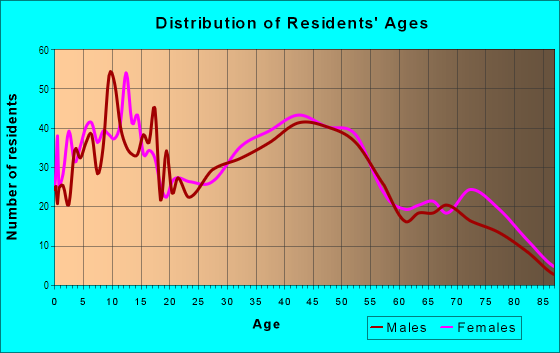
| Males: | 2,534 |
| Females: | 2,409 |
| Males: | 38.6 years |
| Females: | 41.5 years |
Average household size:
| Stelton: | 4.2 people |
| New Jersey: | 2.6 people |
Percentage of family households:
| Stelton: | 56.0% |
| New Jersey: | 47.0% |
| Here: | 68.0% |
| New Jersey: | 49.9% |
Percentage of married-couple families with children (among all households):
| Stelton: | 31.9% |
| New Jersey: | 51.5% |
Percentage of single-mother households (among all households):
| Stelton: | 9.6% |
| New Jersey: | 7.6% |
Percentage of never married males 15 years old and over:
Percentage of never married females 15 years old and over:
| Stelton: | 17.7% |
| New Jersey: | 18.2% |
Percentage of never married females 15 years old and over:
| Stelton: | 13.0% |
| New Jersey: | 16.6% |
Percentage of people that speak English not well or not at all:
| Stelton: | 9.8% |
| New Jersey: | 6.5% |
Percentage of people born in this state:
Percentage of people born in another U.S. state:
Percentage of native residents but born outside the U.S.:
Percentage of foreign born residents:
| Here: | 40.3% |
| New Jersey: | 50.7% |
Percentage of people born in another U.S. state:
| Stelton: | 25.3% |
| New Jersey: | 23.4% |
Percentage of native residents but born outside the U.S.:
| Here: | 2.5% |
| New Jersey: | 2.4% |
Percentage of foreign born residents:
| Here: | 31.8% |
| New Jersey: | 23.5% |
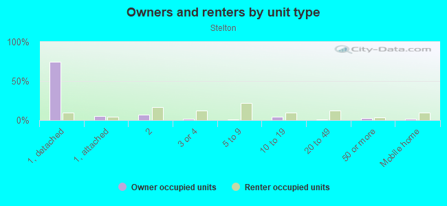
Owner-occupied
Renter-occupied

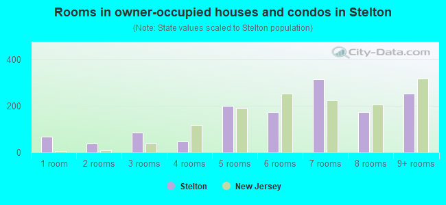
- Rooms in owner-occupied houses and condos in Stelton
- 681 room
- 392 rooms
- 843 rooms
- 474 rooms
- 2015 rooms
- 1736 rooms
- 3157 rooms
- 1738 rooms
- 2539+ rooms
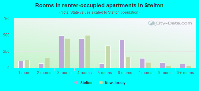
- Rooms in renter-occupied apartments in Stelton
- 1081 room
- 632 rooms
- 4923 rooms
- 4434 rooms
- 665 rooms
- 4246 rooms
- 1447 rooms
- 798 rooms
- 599+ rooms
Owner-occupied
Renter-occupied
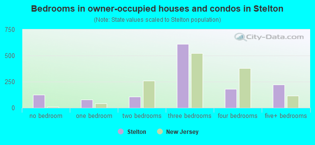
- Bedrooms in owner-occupied houses and condos in Stelton
- 126no bedroom
- 791 bedroom
- 1082 bedrooms
- 6113 bedrooms
- 1794 bedrooms
- 2205+ bedrooms
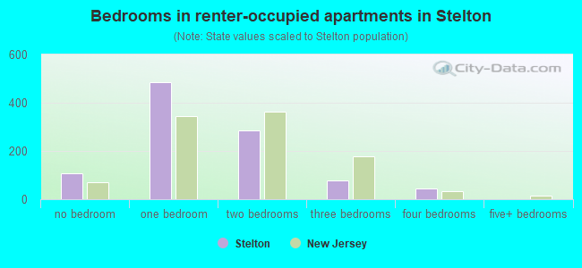
- Bedrooms in renter-occupied apartments in Stelton
- 108no bedroom
- 4841 bedroom
- 2862 bedrooms
- 773 bedrooms
- 464 bedrooms
- 05+ bedrooms
Average number of cars or other vehicles available in houses/condos:
Average number of cars or other vehicles available in apartments:
| This neighborhood: | 1.9 |
| New Jersey: | 2.0 |
Average number of cars or other vehicles available in apartments:
| Here: | 1.3 |
| New Jersey: | 1.1 |
Percentage of units with a mortgage:
| Stelton: | 59.7% |
| New Jersey: | 63.3% |
Average estimated value of detached houses in 2022 (70.5% of all units):
| Stelton: | $503,286 |
| New Jersey: | $537,591 |
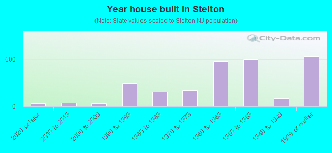
- Year house built in Stelton
- 332020 or later
- 392010 to 2019
- 302000 to 2009
- 2441990 to 1999
- 1491980 to 1989
- 1681970 to 1979
- 4751960 to 1969
- 4971950 to 1959
- 811940 to 1949
- 5301939 or earlier
Travel time to work (commute)
![Travel time to work (commute)]()
- 53Less than 5 minutes
- 2735 to 9 minutes
- 34610 to 14 minutes
- 41415 to 19 minutes
- 29320 to 24 minutes
- 13125 to 29 minutes
- 14230 to 34 minutes
- 4235 to 39 minutes
- 6340 to 44 minutes
- 22745 to 59 minutes
- 29860 to 89 minutes
- 14290 or more minutes

Means of transportation to work
![Means of transportation to work]()
- 68.3%1,646Drove a car alone
- 9.8%235Carpooled
- 4.1%100Bus
- 1.5%37Subway or elevated rail
- 7.7%185Long-distance train or commuter rail
- 5.9%143Taxi
- 2.3%55Walked
- 9.6%232Other means
- 10.3%248Worked at home

Time leaving home to go to work
![Time leaving home to go to work]()
- 8312:00 a.m. to 4:59 a.m.
- 695:00 a.m. to 5:29 a.m.
- 545:30 a.m. to 5:59 a.m.
- 796:00 a.m. to 6:29 a.m.
- 1466:30 a.m. to 6:59 a.m.
- 3147:00 a.m. to 7:29 a.m.
- 1897:30 a.m. to 7:59 a.m.
- 4198:00 a.m. to 8:29 a.m.
- 2118:30 a.m. to 8:59 a.m.
- 2309:00 a.m. to 9:59 a.m.
- 17010:00 a.m. to 10:59 a.m.
- 3711:00 a.m. to 11:59 a.m.
- 16712:00 p.m. to 3:59 p.m.
- 1824:00 p.m. to 11:59 p.m.

Occupations of males:
- Percentage of males in management occupations (except farmers):
Here: 11.4% New Jersey: 13.9%
- Percentage of males in business and financial operations occupations:
Here: 7.7% New Jersey: 6.9%
- Percentage of males in computer and mathematical occupations:
Here: 10.8% New Jersey: 6.5%
- Percentage of males in architecture and engineering occupations:
Here: 3.0% New Jersey: 3.1%
- Percentage of males in life, physical, and social science occupations:
Here: 1.2% New Jersey: 1.2%
- Percentage of males in legal occupations:
Here: 2.2% New Jersey: 1.5%
- Percentage of males in education, training, and library occupations:
Here: 6.1% New Jersey: 3.6%
- Percentage of males in arts, design, entertainment, sports, and media occupations:
Here: 1.0% New Jersey: 2.0%
- Percentage of males in service occupations:
Here: 14.4% New Jersey: 12.9%
- Percentage of males in sales and office occupations:
Here: 14.4% New Jersey: 15.3%
- Percentage of males in construction, extraction, and maintenance occupations:
Here: 4.1% New Jersey: 8.1%
- Percentage of males in production occupations:
Here: 2.2% New Jersey: 4.8%
- Percentage of males in transportation occupations:
Here: 14.2% New Jersey: 6.5%
- Percentage of males in material moving occupations:
Here: 4.4% New Jersey: 4.7%
Occupations of females:
- Percentage of females in management occupations (except farmers):
Here: 13.1% New Jersey: 10.4%
- Percentage of females in business and financial operations occupations:
Here: 8.1% New Jersey: 7.3%
- Percentage of females in computer and mathematical occupations:
Here: 4.4% New Jersey: 2.4%
- Percentage of females in life, physical, and social science occupations:
Here: 1.0% New Jersey: 1.4%
- Percentage of females in legal occupations:
Here: 6.5% New Jersey: 1.6%
- Percentage of females in education, training, and library occupations:
Here: 16.4% New Jersey: 11.4%
- Percentage of females in healthcare practitioners and technical occupations:
Here: 7.8% New Jersey: 9.6%
- Percentage of females in service occupations:
Here: 15.8% New Jersey: 17.2%
- Percentage of females in sales and office occupations:
Here: 23.4% New Jersey: 26.7%
- Percentage of females in construction, extraction, and maintenance occupations:
Here: 1.3% New Jersey: 0.2%
- Percentage of females in material moving occupations:
Here: 2.2% New Jersey: 2.4%
Percentage of people 16-64 in Armed Forces:
| Stelton: | 0.2% |
| New Jersey: | 0.2% |
Education in this neighborhood (subdivision or community):
- Percentage of people 3 years and older in K-12 schools:
Stelton: 17.2% New Jersey: 16.6%
- Percentage of people 3 years and older in undergraduate colleges:
Stelton: 6.1% New Jersey: 4.9%
- Percentage of people 3 years and older in grad. or professional schools:
Stelton: 2.6% New Jersey: 1.6%
- Percentage of students K-12 enrolled in private schools:
Stelton: 244.2% New Jersey: 12.7%
Percentage of population below poverty level:
| Stelton: | 7.3% |
| New Jersey: | 9.7% |
Median year owner moved in (as recorded in 2022):
| Stelton: | 2000 |
| New Jersey: | 2008 |
Percentage of married-couple families with both working:
| Stelton: | 61.2% |
| New Jersey: | 72.0% |
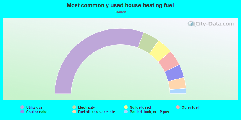
- 61.5%Utility gas
- 8.3%Electricity
- 7.9%No fuel used
- 7.7%Other fuel
- 6.6%Coal or coke
- 5.5%Fuel oil, kerosene, etc.
- 2.5%Bottled, tank, or LP gas
Highways in this neighborhood:
Lincoln Hwy (State Rte 27)
Length: 1.42 miles
Direction: SW-NE
Address range: 1500 to 1925
Direction: SW-NE
Address range: 1500 to 1925
Raritan Ave (State Rte 27)
Length: 0.55 miles
Direction: SW-NE
Address range: 800 to 1298
Direction: SW-NE
Address range: 800 to 1298
Roads and streets:
Central Ave
Length: 1.07 miles
Directions: E-W, SW-NE
Address range: 158 to 370
Directions: E-W, SW-NE
Address range: 158 to 370
N 8th Ave
Length: 0.74 miles
Directions: N-S, SE-NW
Address range: 1 to 499
Directions: N-S, SE-NW
Address range: 1 to 499
Duclos Ln (Co Rd 676)
Length: 0.67 miles
Directions: E-W, SE-NW
Address range: 174 to 411
Directions: E-W, SE-NW
Address range: 174 to 411
Eardley Rd
Length: 0.62 miles
Directions: E-W, SW-NE
Address range: 1 to 81
Directions: E-W, SW-NE
Address range: 1 to 81
Plainfield Ave
Length: 0.60 miles
Direction: SE-NW
Address range: 282 to 409
Direction: SE-NW
Address range: 282 to 409
Highland Ave
Length: 0.50 miles
Direction: N-S
Address range: 2 to 246
Direction: N-S
Address range: 2 to 246
Marshall Dr
Length: 0.48 miles
Directions: E-W, N-S, SW-NE
Address range: 1 to 99
Directions: E-W, N-S, SW-NE
Address range: 1 to 99
Chestnut St
Length: 0.47 miles
Direction: SW-NE
Address range: 1 to 65
Direction: SW-NE
Address range: 1 to 65
Runyon Ave
Length: 0.46 miles
Direction: SW-NE
Address range: 3 to 60
Direction: SW-NE
Address range: 3 to 60
Stony Rd W
Length: 0.46 miles
Direction: SE-NW
Address range: 1 to 70
Direction: SE-NW
Address range: 1 to 70
Washington Ave
Length: 0.45 miles
Direction: N-S
Address range: 3 to 242
Direction: N-S
Address range: 3 to 242
Brookfall Rd
Length: 0.44 miles
Directions: E-W, N-S, SW-NE
Address range: 1 to 57
Directions: E-W, N-S, SW-NE
Address range: 1 to 57
Lexington Ave
Length: 0.41 miles
Direction: N-S
Address range: 3 to 155
Direction: N-S
Address range: 3 to 155
Division St
Length: 0.40 miles
Directions: N-S, SE-NW, SW-NE
Address range: 289 to 499
Directions: N-S, SE-NW, SW-NE
Address range: 289 to 499
Andre Ave
Length: 0.38 miles
Direction: SE-NW
Address range: 3 to 60
Direction: SE-NW
Address range: 3 to 60
Brookhill Ave
Length: 0.38 miles
Directions: N-S, SE-NW, SW-NE
Address range: 1 to 142
Directions: N-S, SE-NW, SW-NE
Address range: 1 to 142
Walnut St
Length: 0.37 miles
Direction: SW-NE
Address range: 1 to 49
Direction: SW-NE
Address range: 1 to 49
Mineola Pl
Length: 0.35 miles
Direction: E-W
Address range: 40 to 1123
Direction: E-W
Address range: 40 to 1123
Gaskill Ave
Length: 0.34 miles
Directions: E-W, SW-NE
Address range: 1 to 99
Directions: E-W, SW-NE
Address range: 1 to 99
Leslie St
Length: 0.33 miles
Direction: E-W
Address range: 1 to 120
Direction: E-W
Address range: 1 to 120
Hillcrest Ave
Length: 0.31 miles
Direction: SE-NW
Address range: 111 to 199
Direction: SE-NW
Address range: 111 to 199
Price Dr
Length: 0.31 miles
Directions: E-W, N-S, SE-NW, SW-NE
Address range: 1 to 47
Directions: E-W, N-S, SE-NW, SW-NE
Address range: 1 to 47
Partch Pl
Length: 0.31 miles
Directions: N-S, SE-NW
Address range: 1 to 59
Directions: N-S, SE-NW
Address range: 1 to 59
Barlow Rd
Length: 0.31 miles
Directions: E-W, SW-NE
Address range: 1 to 42
Directions: E-W, SW-NE
Address range: 1 to 42
Greenwood Ave
Length: 0.30 miles
Direction: SW-NE
Address range: 100 to 199
Direction: SW-NE
Address range: 100 to 199
Sims Rd
Length: 0.30 miles
Directions: N-S, SE-NW, SW-NE
Address range: 1 to 44
Directions: N-S, SE-NW, SW-NE
Address range: 1 to 44
Carmello Dr
Length: 0.29 miles
Directions: E-W, SW-NE
Address range: 1 to 44
Directions: E-W, SW-NE
Address range: 1 to 44
Lahiere Ave
Length: 0.29 miles
Direction: SW-NE
Address range: 1 to 48
Direction: SW-NE
Address range: 1 to 48
Dalton Pl
Length: 0.29 miles
Direction: SW-NE
Address range: 1 to 45
Direction: SW-NE
Address range: 1 to 45
Back Dr
Length: 0.29 miles
Directions: E-W, N-S, SE-NW, SW-NE
Address range: 1 to 45
Directions: E-W, N-S, SE-NW, SW-NE
Address range: 1 to 45
N 9th Ave
Length: 0.28 miles
Directions: N-S, SE-NW, SW-NE
Address range: 1 to 199
Directions: N-S, SE-NW, SW-NE
Address range: 1 to 199
Fairhill Rd
Length: 0.26 miles
Direction: E-W
Address range: 1 to 35
Direction: E-W
Address range: 1 to 35
N 10th Ave
Length: 0.24 miles
Direction: N-S
Address range: 1 to 199
Direction: N-S
Address range: 1 to 199
Campbell Ave
Length: 0.24 miles
Direction: SE-NW
Address range: 3 to 95
Direction: SE-NW
Address range: 3 to 95
Prospect Ave
Length: 0.23 miles
Direction: SE-NW
Address range: 142 to 183
Direction: SE-NW
Address range: 142 to 183
Ely Pl
Length: 0.22 miles
Directions: E-W, N-S, SE-NW, SW-NE
Address range: 1 to 37
Directions: E-W, N-S, SE-NW, SW-NE
Address range: 1 to 37
Sheppard Pl
Length: 0.22 miles
Direction: SE-NW
Address range: 1 to 99
Direction: SE-NW
Address range: 1 to 99
S Park Ave
Length: 0.22 miles
Directions: E-W, N-S
Address range: 900 to 1099
Directions: E-W, N-S
Address range: 900 to 1099
Ryan Rd
Length: 0.22 miles
Directions: E-W, N-S, SE-NW, SW-NE
Address range: 1 to 35
Directions: E-W, N-S, SE-NW, SW-NE
Address range: 1 to 35
Knapp Ave
Length: 0.20 miles
Direction: SE-NW
Address range: 1 to 99
Direction: SE-NW
Address range: 1 to 99
N 11th Ave
Length: 0.19 miles
Direction: N-S
Address range: 1 to 199
Direction: N-S
Address range: 1 to 199
Abbott St
Length: 0.19 miles
Direction: E-W
Address range: 800 to 1099
Direction: E-W
Address range: 800 to 1099
Taft Ave
Length: 0.17 miles
Directions: N-S, SE-NW
Address range: 40 to 125
Directions: N-S, SE-NW
Address range: 40 to 125
Vinal Ave
Length: 0.16 miles
Directions: E-W, SE-NW, SW-NE
Address range: 1 to 50
Directions: E-W, SE-NW, SW-NE
Address range: 1 to 50
Clark Ave
Length: 0.14 miles
Direction: SE-NW
Address range: 1 to 61
Direction: SE-NW
Address range: 1 to 61
Suydam Ave
Length: 0.14 miles
Direction: N-S
Address range: 46 to 99
Direction: N-S
Address range: 46 to 99
Reed St
Length: 0.13 miles
Direction: SE-NW
Address range: 1 to 36
Direction: SE-NW
Address range: 1 to 36
Porter St
Length: 0.13 miles
Direction: SE-NW
Address range: 1 to 40
Direction: SE-NW
Address range: 1 to 40
Barlow Rd W
Length: 0.13 miles
Direction: SW-NE
Address range: 1 to 14
Direction: SW-NE
Address range: 1 to 14
Hillside Ave
Length: 0.13 miles
Direction: SW-NE
Address range: 100 to 129
Direction: SW-NE
Address range: 100 to 129
Nelson Ave
Length: 0.13 miles
Direction: SE-NW
Address range: 1 to 54
Direction: SE-NW
Address range: 1 to 54
Stone St
Length: 0.12 miles
Direction: E-W
Address range: 2 to 38
Direction: E-W
Address range: 2 to 38
Drier Pl
Length: 0.12 miles
Direction: E-W
Address range: 1300 to 1399
Direction: E-W
Address range: 1300 to 1399
Poll Pl
Length: 0.12 miles
Direction: SE-NW
Address range: 300 to 399
Direction: SE-NW
Address range: 300 to 399
Highway Ter
Length: 0.12 miles
Directions: N-S, SE-NW
Address range: 3 to 37
Directions: N-S, SE-NW
Address range: 3 to 37
Prescott St
Length: 0.11 miles
Direction: SE-NW
Address range: 1 to 34
Direction: SE-NW
Address range: 1 to 34
Rutgers St
Length: 0.10 miles
Direction: SE-NW
Address range: 1 to 36
Direction: SE-NW
Address range: 1 to 36
Lenox St
Length: 0.10 miles
Direction: SE-NW
Address range: 1 to 40
Direction: SE-NW
Address range: 1 to 40
Dix Ave
Length: 0.09 miles
Direction: SW-NE
Address range: 1 to 32
Direction: SW-NE
Address range: 1 to 32
Cornell St
Length: 0.08 miles
Direction: SW-NE
Address range: 1 to 99
Direction: SW-NE
Address range: 1 to 99
Alice Ave
Length: 0.08 miles
Direction: SE-NW
Direction: SE-NW
Archer Pl
Length: 0.06 miles
Direction: E-W
Address range: 1 to 99
Direction: E-W
Address range: 1 to 99
Manor Ct
Length: 0.06 miles
Directions: N-S, SE-NW
Address range: 1 to 99
Directions: N-S, SE-NW
Address range: 1 to 99
Cliff St
Length: 0.05 miles
Direction: E-W
Direction: E-W
Prospect St
Length: 0.04 miles
Direction: SE-NW
Direction: SE-NW
Railroad features:
Conrail RR
Length: 1.39 miles
Direction: SW-NE
Direction: SW-NE
Other features:
Mill Brk
Length: 1.74 miles
Directions: E-W, SE-NW, SW-NE
Directions: E-W, SE-NW, SW-NE