Stewart Town neighborhood in Gaithersburg, Maryland (MD), 20879, 20886 detailed profile
Settings
X


Business Search - 14 Million verified businesses
Area: 1.420 square miles
Population: 15,437
Population density:
| Stewart Town: | 10,871 people per square mile |
| Gaithersburg: | 6,836 people per square mile |

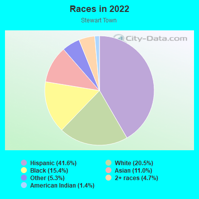
- 6,67141.6%Hispanic or Latino
- 3,29120.5%White
- 2,47215.4%Black
- 1,76211.0%Asian
- 8575.3%Some other race
- 7614.7%Two or more races
- 2181.4%American Indian
Distribution of median household income
![Distribution of median household income]()
- 166Less than $10,000
- 227$10,000 to $19,999
- 358$20,000 to $29,999
- 531$30,000 to $39,999
- 266$40,000 to $49,999
- 542$50,000 to $59,999
- 386$60,000 to $74,999
- 721$75,000 to $99,999
- 442$100,000 to $124,999
- 468$125,000 to $149,999
- 636$150,000 to $199,999
- 738$200,000 or more

Distribution of owner-occupied house/condo value
![Distribution of owner-occupied house/condo value]()
- 713Less than $50,000
- 120$50,000 to $99,999
- 151$100,000 to $149,999
- 204$150,000 to $199,999
- 109$200,000 to $249,999
- 516$250,000 to $299,999
- 1,177$300,000 to $399,999
- 932$400,000 to $499,999
- 906$500,000 to $749,999
- 102$750,000 to $999,999
- 337$1,000,000 or more

Distribution of rent paid by renters
![Distribution of rent paid by renters]()
- 23$200 to $299
- 185$600 to $699
- 1,169$700 to $799
- 25$900 to $999
- 183$1,000 to $1,249
- 119$1,250 to $1,499
- 248$1,500 to $1,999
- 622$2,000 or more

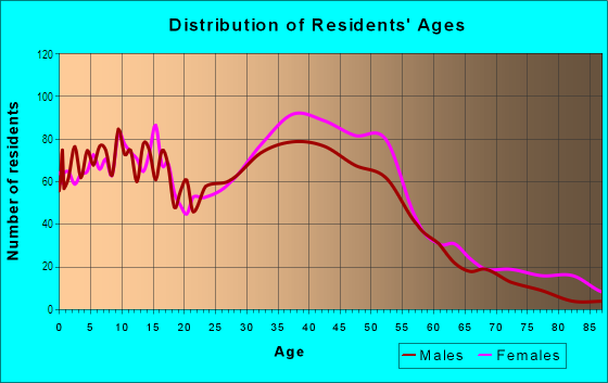
| Males: | 7,115 |
| Females: | 8,322 |
Males:
| This neighborhood: | 38.1 years |
| Whole city: | 35.1 years |
| This neighborhood: | 40.3 years |
| Whole city: | 38.3 years |
Average household size:
| Stewart Town: | 4.8 people |
| Gaithersburg: | 2.8 people |
Percentage of family households:
| Stewart Town: | 52.6% |
| Gaithersburg: | 46.2% |
| Here: | 58.2% |
| Gaithersburg: | 45.7% |
Percentage of married-couple families with children (among all households):
| Stewart Town: | 24.1% |
| Gaithersburg: | 28.7% |
Percentage of single-mother households (among all households):
| Stewart Town: | 4.2% |
| Gaithersburg: | 5.5% |
Percentage of never married males 15 years old and over:
Percentage of never married females 15 years old and over:
| Stewart Town: | 16.1% |
| Gaithersburg: | 17.1% |
Percentage of never married females 15 years old and over:
| Stewart Town: | 17.4% |
| city: | 20.4% |
Percentage of people that speak English not well or not at all:
| Stewart Town: | 13.0% |
| Gaithersburg: | 11.9% |
Percentage of people born in this state:
Percentage of people born in another U.S. state:
Percentage of native residents but born outside the U.S.:
Percentage of foreign born residents:
| Here: | 35.3% |
| Gaithersburg: | 29.0% |
Percentage of people born in another U.S. state:
| Stewart Town: | 26.6% |
| Gaithersburg: | 27.2% |
Percentage of native residents but born outside the U.S.:
| Here: | 1.4% |
| city: | 2.5% |
Percentage of foreign born residents:
| Here: | 36.8% |
| Gaithersburg: | 41.2% |
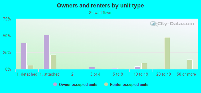
Owner-occupied
Renter-occupied

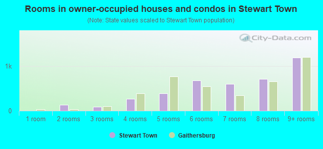
- Rooms in owner-occupied houses and condos in Stewart Town
- 01 room
- 1372 rooms
- 873 rooms
- 2654 rooms
- 3905 rooms
- 6786 rooms
- 5977 rooms
- 7088 rooms
- 1,1919+ rooms
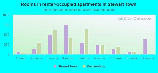
- Rooms in renter-occupied apartments in Stewart Town
- 621 room
- 1442 rooms
- 4873 rooms
- 7594 rooms
- 2985 rooms
- 2366 rooms
- 1387 rooms
- 568 rooms
- 3879+ rooms
Owner-occupied
Renter-occupied
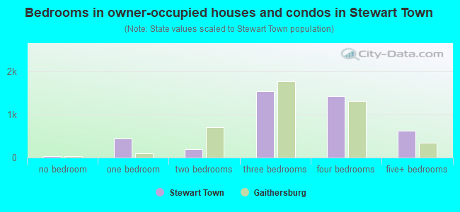
- Bedrooms in owner-occupied houses and condos in Stewart Town
- 26no bedroom
- 4481 bedroom
- 1992 bedrooms
- 1,5363 bedrooms
- 1,4164 bedrooms
- 6225+ bedrooms
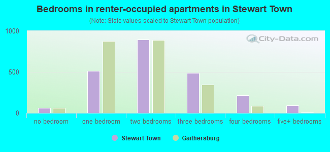
- Bedrooms in renter-occupied apartments in Stewart Town
- 62no bedroom
- 5131 bedroom
- 8962 bedrooms
- 4903 bedrooms
- 2134 bedrooms
- 925+ bedrooms
Average number of cars or other vehicles available in houses/condos:
Average number of cars or other vehicles available in apartments:
| This neighborhood: | 2.5 |
| Gaithersburg: | 1.9 |
Average number of cars or other vehicles available in apartments:
| Here: | 2.0 |
| city: | 1.2 |
Percentage of units with a mortgage:
| Stewart Town: | 69.3% |
| Gaithersburg: | 74.0% |
Average estimated value of detached houses in 2022 (43.8% of all units):
| Stewart Town: | $491,567 |
| Maryland: | $526,819 |
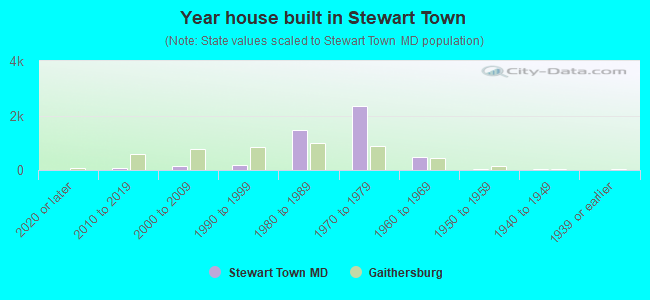
- Year house built in Stewart Town
- 02020 or later
- 772010 to 2019
- 1632000 to 2009
- 1691990 to 1999
- 1,4651980 to 1989
- 2,3431970 to 1979
- 4871960 to 1969
- 491950 to 1959
- 271940 to 1949
- 181939 or earlier
Travel time to work (commute)
![Travel time to work (commute)]()
- 60Less than 5 minutes
- 1635 to 9 minutes
- 48610 to 14 minutes
- 73215 to 19 minutes
- 80820 to 24 minutes
- 33925 to 29 minutes
- 79630 to 34 minutes
- 15835 to 39 minutes
- 29640 to 44 minutes
- 1,06245 to 59 minutes
- 44060 to 89 minutes
- 28990 or more minutes

Means of transportation to work
![Means of transportation to work]()
- 72.2%5,421Drove a car alone
- 9.6%718Carpooled
- 6.8%510Bus
- 2.3%171Subway or elevated rail
- 1.3%96Long-distance train or commuter rail
- 4.9%369Taxi
- 0.3%26Bicycle
- 1.5%109Walked
- 0.4%28Other means
- 10.7%801Worked at home

Time leaving home to go to work
![Time leaving home to go to work]()
- 30012:00 a.m. to 4:59 a.m.
- 3805:00 a.m. to 5:29 a.m.
- 1885:30 a.m. to 5:59 a.m.
- 6456:00 a.m. to 6:29 a.m.
- 2466:30 a.m. to 6:59 a.m.
- 5967:00 a.m. to 7:29 a.m.
- 3267:30 a.m. to 7:59 a.m.
- 6768:00 a.m. to 8:29 a.m.
- 2998:30 a.m. to 8:59 a.m.
- 3699:00 a.m. to 9:59 a.m.
- 13510:00 a.m. to 10:59 a.m.
- 10111:00 a.m. to 11:59 a.m.
- 45812:00 p.m. to 3:59 p.m.
- 4324:00 p.m. to 11:59 p.m.

Occupations of males:
- Percentage of males in management occupations (except farmers):
Here: 6.2% city: 13.3%
- Percentage of males in business and financial operations occupations:
Here: 6.0% city: 7.2%
- Percentage of males in computer and mathematical occupations:
Here: 7.8% city: 12.5%
- Percentage of males in architecture and engineering occupations:
Here: 3.5% city: 3.2%
- Percentage of males in life, physical, and social science occupations:
Here: 3.8% city: 5.5%
- Percentage of males in education, training, and library occupations:
Here: 3.9% city: 2.2%
- Percentage of males in arts, design, entertainment, sports, and media occupations:
Here: 3.0% city: 2.8%
- Percentage of males in healthcare practitioners and technical occupations:
Here: 1.1% city: 2.9%
- Percentage of males in service occupations:
Here: 8.1% city: 14.1%
- Percentage of males in sales and office occupations:
Here: 14.5% city: 11.6%
- Percentage of males in construction, extraction, and maintenance occupations:
Here: 9.3% city: 10.3%
- Percentage of males in production occupations:
Here: 12.6% city: 3.0%
- Percentage of males in transportation occupations:
Here: 7.2% city: 4.3%
- Percentage of males in material moving occupations:
Here: 7.4% city: 1.0%
Occupations of females:
- Percentage of females in management occupations (except farmers):
Here: 5.9% city: 11.1%
- Percentage of females in business and financial operations occupations:
Here: 10.0% city: 9.3%
- Percentage of females in computer and mathematical occupations:
Here: 3.3% city: 4.5%
- Percentage of females in community and social services occupations:
Here: 3.0% city: 2.3%
- Percentage of females in education, training, and library occupations:
Here: 10.2% city: 7.5%
- Percentage of females in healthcare practitioners and technical occupations:
Here: 4.8% city: 7.5%
- Percentage of females in service occupations:
Here: 31.6% city: 20.2%
- Percentage of females in sales and office occupations:
Here: 25.0% city: 22.1%
- Percentage of females in production occupations:
Here: 2.3% city: 2.4%
Percentage of people 16-64 in Armed Forces:
| Stewart Town: | 0.3% |
| Gaithersburg: | 0.4% |
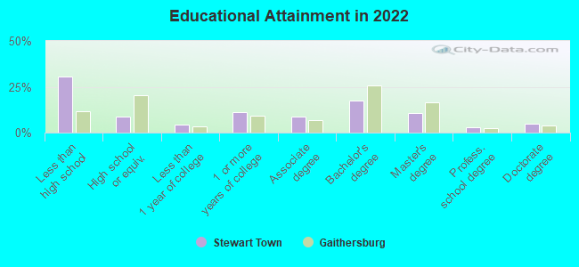
Education in this neighborhood (subdivision or community):
- Percentage of people 3 years and older in K-12 schools:
Stewart Town: 27.4% Gaithersburg: 16.1%
- Percentage of people 3 years and older in undergraduate colleges:
Stewart Town: 6.4% Gaithersburg: 4.1%
- Percentage of people 3 years and older in grad. or professional schools:
Stewart Town: 2.2% Gaithersburg: 1.4%
- Percentage of students K-12 enrolled in private schools:
Stewart Town: 31.3% Gaithersburg: 6.2%
Percentage of population below poverty level:
| Stewart Town: | 11.5% |
| Gaithersburg: | 5.9% |
Median year owner moved in (as recorded in 2022):
| Stewart Town: | 2007 |
| Gaithersburg: | 2011 |
Percentage of married-couple families with both working:
| Stewart Town: | 74.1% |
| Gaithersburg: | 72.9% |
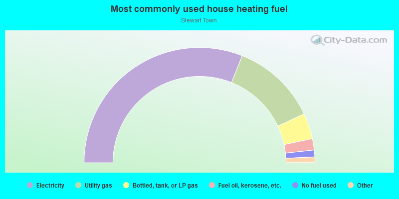
- 62.1%Electricity
- 24.0%Utility gas
- 7.2%Bottled, tank, or LP gas
- 3.2%Fuel oil, kerosene, etc.
- 1.9%No fuel used
- 0.8%Other fuel
- 0.7%Solar energy
Roads and streets:
Centerway Rd
Length: 1.81 miles
Directions: E-W, N-S, SE-NW, SW-NE
Address range: 8900 to 9799
Directions: E-W, N-S, SE-NW, SW-NE
Address range: 8900 to 9799
Goshen Rd
Length: 1.20 miles
Directions: N-S, SW-NE
Address range: 19400 to 20066
Directions: N-S, SW-NE
Address range: 19400 to 20066
Stewartown Rd
Length: 0.87 miles
Directions: E-W, SE-NW, SW-NE
Address range: 9201 to 9599
Directions: E-W, SE-NW, SW-NE
Address range: 9201 to 9599
Framingham Dr
Length: 0.76 miles
Directions: E-W, N-S, SE-NW, SW-NE
Address range: 19400 to 19765
Directions: E-W, N-S, SE-NW, SW-NE
Address range: 19400 to 19765
Snouffers School Rd
Length: 0.67 miles
Directions: N-S, SE-NW
Address range: 8600 to 8799
Directions: N-S, SE-NW
Address range: 8600 to 8799
Montgomery Village Ave
Length: 0.52 miles
Directions: N-S, SW-NE
Directions: N-S, SW-NE
Ridge Heights Dr
Length: 0.50 miles
Directions: E-W, N-S, SE-NW, SW-NE
Address range: 19500 to 19644
Directions: E-W, N-S, SE-NW, SW-NE
Address range: 19500 to 19644
Alliston Hollow Way
Length: 0.49 miles
Directions: E-W, N-S, SE-NW, SW-NE
Address range: 8800 to 8999
Directions: E-W, N-S, SE-NW, SW-NE
Address range: 8800 to 8999
Amboy Rd
Length: 0.48 miles
Directions: E-W, SE-NW
Directions: E-W, SE-NW
Bazzleton Pl
Length: 0.46 miles
Directions: E-W, N-S, SW-NE
Address range: 19639 to 19875
Directions: E-W, N-S, SW-NE
Address range: 19639 to 19875
Rothbury Dr
Length: 0.45 miles
Directions: E-W, SW-NE
Address range: 9100 to 9199
Directions: E-W, SW-NE
Address range: 9100 to 9199
Transhire Rd
Length: 0.44 miles
Directions: E-W, N-S, SE-NW, SW-NE
Address range: 19300 to 19591
Directions: E-W, N-S, SE-NW, SW-NE
Address range: 19300 to 19591
Arrow Head Rd
Length: 0.44 miles
Directions: N-S, SE-NW
Directions: N-S, SE-NW
Bramble Bush Dr
Length: 0.43 miles
Directions: E-W, N-S, SE-NW, SW-NE
Address range: 19118 to 20006
Directions: E-W, N-S, SE-NW, SW-NE
Address range: 19118 to 20006
Duffer Way
Length: 0.38 miles
Directions: E-W, N-S, SE-NW, SW-NE
Address range: 9500 to 9699
Directions: E-W, N-S, SE-NW, SW-NE
Address range: 9500 to 9699
Roundleaf Way
Length: 0.37 miles
Directions: E-W, N-S, SE-NW, SW-NE
Address range: 8900 to 9145
Directions: E-W, N-S, SE-NW, SW-NE
Address range: 8900 to 9145
Blue Smoke Dr
Length: 0.37 miles
Directions: E-W, N-S, SE-NW, SW-NE
Address range: 8800 to 8938
Directions: E-W, N-S, SE-NW, SW-NE
Address range: 8800 to 8938
Hob Hill Way
Length: 0.35 miles
Directions: E-W, N-S, SE-NW, SW-NE
Address range: 20000 to 20163
Directions: E-W, N-S, SE-NW, SW-NE
Address range: 20000 to 20163
Turtle Dove Ln
Length: 0.34 miles
Directions: E-W, N-S, SE-NW, SW-NE
Address range: 9001 to 9226
Directions: E-W, N-S, SE-NW, SW-NE
Address range: 9001 to 9226
Fern Hollow Way
Length: 0.33 miles
Directions: E-W, SW-NE
Address range: 9400 to 9598
Directions: E-W, SW-NE
Address range: 9400 to 9598
Laguna Dr
Length: 0.32 miles
Directions: E-W, N-S, SE-NW, SW-NE
Address range: 19400 to 19549
Directions: E-W, N-S, SE-NW, SW-NE
Address range: 19400 to 19549
Sandy Lake Dr
Length: 0.31 miles
Directions: E-W, N-S, SE-NW, SW-NE
Directions: E-W, N-S, SE-NW, SW-NE
Fessenden Ln
Length: 0.29 miles
Directions: E-W, N-S, SE-NW, SW-NE
Directions: E-W, N-S, SE-NW, SW-NE
Chesley Knoll Dr
Length: 0.28 miles
Directions: N-S, SW-NE
Address range: 19814 to 19942
Directions: N-S, SW-NE
Address range: 19814 to 19942
Thomas Farm Rd
Length: 0.27 miles
Direction: SW-NE
Address range: 10141 to 19499
Direction: SW-NE
Address range: 10141 to 19499
Bramble Bush Ct
Length: 0.27 miles
Directions: E-W, N-S, SE-NW, SW-NE
Address range: 9000 to 9199
Directions: E-W, N-S, SE-NW, SW-NE
Address range: 9000 to 9199
Broadwater Dr
Length: 0.25 miles
Directions: E-W, N-S, SE-NW, SW-NE
Address range: 9200 to 9399
Directions: E-W, N-S, SE-NW, SW-NE
Address range: 9200 to 9399
Keymar Way
Length: 0.25 miles
Directions: E-W, N-S, SE-NW, SW-NE
Address range: 19300 to 19399
Directions: E-W, N-S, SE-NW, SW-NE
Address range: 19300 to 19399
Spr Hill Dr
Length: 0.25 miles
Directions: E-W, N-S, SW-NE
Address range: 19900 to 20099
Directions: E-W, N-S, SW-NE
Address range: 19900 to 20099
Frostburg Way
Length: 0.24 miles
Directions: E-W, N-S, SW-NE
Address range: 9200 to 9399
Directions: E-W, N-S, SW-NE
Address range: 9200 to 9399
Hickory View Way
Length: 0.23 miles
Directions: E-W, N-S, SE-NW, SW-NE
Address range: 9401 to 9473
Directions: E-W, N-S, SE-NW, SW-NE
Address range: 9401 to 9473
Chesley Knoll Ct
Length: 0.23 miles
Directions: E-W, N-S, SE-NW, SW-NE
Address range: 9000 to 9153
Directions: E-W, N-S, SE-NW, SW-NE
Address range: 9000 to 9153
Poinsetta Ct
Length: 0.22 miles
Directions: E-W, N-S, SE-NW
Address range: 19300 to 19423
Directions: E-W, N-S, SE-NW
Address range: 19300 to 19423
Merust Ln
Length: 0.22 miles
Directions: E-W, SE-NW
Address range: 9300 to 9499
Directions: E-W, SE-NW
Address range: 9300 to 9499
Kanfer Ct
Length: 0.21 miles
Directions: E-W, N-S, SE-NW, SW-NE
Address range: 9600 to 9699
Directions: E-W, N-S, SE-NW, SW-NE
Address range: 9600 to 9699
Club House Rd
Length: 0.21 miles
Directions: E-W, N-S, SE-NW
Address range: 4900 to 19399
Directions: E-W, N-S, SE-NW
Address range: 4900 to 19399
Greenside Ter
Length: 0.20 miles
Directions: E-W, SW-NE
Address range: 19700 to 19827
Directions: E-W, SW-NE
Address range: 19700 to 19827
Brassie Way
Length: 0.19 miles
Directions: E-W, N-S, SE-NW
Address range: 9600 to 19498
Directions: E-W, N-S, SE-NW
Address range: 9600 to 19498
Taverney Dr
Length: 0.19 miles
Directions: N-S, SE-NW, SW-NE
Address range: 19500 to 19599
Directions: N-S, SE-NW, SW-NE
Address range: 19500 to 19599
Green Run Way
Length: 0.19 miles
Directions: E-W, SW-NE
Address range: 9000 to 9099
Directions: E-W, SW-NE
Address range: 9000 to 9099
Tippett Ln
Length: 0.18 miles
Directions: E-W, N-S, SE-NW
Address range: 9500 to 9699
Directions: E-W, N-S, SE-NW
Address range: 9500 to 9699
No Name Rd
Length: 0.18 miles
Direction: SE-NW
Direction: SE-NW
Mourning Dove Ct
Length: 0.17 miles
Directions: E-W, N-S, SW-NE
Address range: 8800 to 8899
Directions: E-W, N-S, SW-NE
Address range: 8800 to 8899
Brassie Pl
Length: 0.16 miles
Directions: E-W, SW-NE
Address range: 19400 to 19485
Directions: E-W, SW-NE
Address range: 19400 to 19485
Kinglet Pl
Length: 0.16 miles
Directions: E-W, N-S, SW-NE
Address range: 19100 to 19144
Directions: E-W, N-S, SW-NE
Address range: 19100 to 19144
Marston Ln
Length: 0.16 miles
Direction: SE-NW
Address range: 9500 to 9657
Direction: SE-NW
Address range: 9500 to 9657
Bremerton Way
Length: 0.16 miles
Direction: E-W
Address range: 9300 to 9387
Direction: E-W
Address range: 9300 to 9387
Briar Glenn Way
Length: 0.15 miles
Directions: E-W, N-S, SE-NW, SW-NE
Address range: 9500 to 9836
Directions: E-W, N-S, SE-NW, SW-NE
Address range: 9500 to 9836
Cochrane Way
Length: 0.14 miles
Directions: E-W, SE-NW
Address range: 19800 to 19848
Directions: E-W, SE-NW
Address range: 19800 to 19848
Billings Ct
Length: 0.14 miles
Directions: E-W, N-S, SW-NE
Address range: 19800 to 19852
Directions: E-W, N-S, SW-NE
Address range: 19800 to 19852
Quill Pl
Length: 0.12 miles
Direction: SW-NE
Address range: 9400 to 9499
Direction: SW-NE
Address range: 9400 to 9499
Turtle Dove Ct
Length: 0.12 miles
Directions: E-W, N-S, SW-NE
Directions: E-W, N-S, SW-NE
Drop Forge Ln
Length: 0.12 miles
Directions: N-S, SE-NW
Address range: 19700 to 19744
Directions: N-S, SE-NW
Address range: 19700 to 19744
Labelle Ln (la Belle Ln)
Length: 0.12 miles
Directions: E-W, N-S, SE-NW, SW-NE
Address range: 9200 to 9299
Directions: E-W, N-S, SE-NW, SW-NE
Address range: 9200 to 9299
Waxwing Ter
Length: 0.12 miles
Directions: E-W, SE-NW, SW-NE
Address range: 8700 to 8824
Directions: E-W, SE-NW, SW-NE
Address range: 8700 to 8824
Waringwood Way
Length: 0.12 miles
Direction: N-S
Address range: 20111 to 20199
Direction: N-S
Address range: 20111 to 20199
Hoffstead Ln
Length: 0.11 miles
Directions: N-S, SE-NW
Address range: 20001 to 20099
Directions: N-S, SE-NW
Address range: 20001 to 20099
Weathervane Pl
Length: 0.11 miles
Directions: E-W, SW-NE
Address range: 9200 to 9355
Directions: E-W, SW-NE
Address range: 9200 to 9355
Chatteroy Pl
Length: 0.11 miles
Direction: E-W
Address range: 9400 to 9499
Direction: E-W
Address range: 9400 to 9499
Broadwater Way
Length: 0.11 miles
Directions: N-S, SE-NW, SW-NE
Address range: 9301 to 19199
Directions: N-S, SE-NW, SW-NE
Address range: 9301 to 19199
Framingham Ct
Length: 0.10 miles
Directions: E-W, N-S, SE-NW, SW-NE
Address range: 1 to 34
Directions: E-W, N-S, SE-NW, SW-NE
Address range: 1 to 34
Cochrane Ct
Length: 0.10 miles
Directions: N-S, SW-NE
Address range: 8800 to 8832
Directions: N-S, SW-NE
Address range: 8800 to 8832
Brassie Ct
Length: 0.10 miles
Directions: E-W, SW-NE
Address range: 1 to 19485
Directions: E-W, SW-NE
Address range: 1 to 19485
Eagleton Ln
Length: 0.09 miles
Direction: SE-NW
Address range: 9401 to 9431
Direction: SE-NW
Address range: 9401 to 9431
Billing Ct
Length: 0.09 miles
Directions: SE-NW, SW-NE
Directions: SE-NW, SW-NE
Green Run Ct
Length: 0.08 miles
Directions: N-S, SE-NW
Address range: 9000 to 20132
Directions: N-S, SE-NW
Address range: 9000 to 20132
Stewartown Ter
Length: 0.08 miles
Directions: N-S, SW-NE
Address range: 19600 to 19699
Directions: N-S, SW-NE
Address range: 19600 to 19699
Taverney Ter
Length: 0.07 miles
Direction: E-W
Address range: 9300 to 9336
Direction: E-W
Address range: 9300 to 9336
Lumaryn Pl
Length: 0.07 miles
Direction: N-S
Direction: N-S
Sandy Lake Cir
Length: 0.06 miles
Direction: N-S
Direction: N-S
Turtle Dove Ter
Length: 0.06 miles
Direction: E-W
Address range: 19500 to 19515
Direction: E-W
Address range: 19500 to 19515
Harkness Ln
Length: 0.06 miles
Directions: N-S, SE-NW
Address range: 19100 to 19122
Directions: N-S, SE-NW
Address range: 19100 to 19122
Rock Elm Way
Length: 0.06 miles
Directions: E-W, SW-NE
Directions: E-W, SW-NE
Ridge Heights Ct
Length: 0.06 miles
Direction: E-W
Address range: 1 to 24
Direction: E-W
Address range: 1 to 24
Ivory Gull Ct
Length: 0.06 miles
Direction: E-W
Address range: 8800 to 8815
Direction: E-W
Address range: 8800 to 8815
Burr Oak Rd
Length: 0.05 miles
Direction: N-S
Direction: N-S
Meadowcroft Ln
Length: 0.05 miles
Direction: E-W
Direction: E-W
Trams Way
Length: 0.05 miles
Direction: E-W
Address range: 9100 to 9199
Direction: E-W
Address range: 9100 to 9199
Blue Smoke Ct
Length: 0.05 miles
Directions: E-W, SE-NW
Address range: 1 to 34
Directions: E-W, SE-NW
Address range: 1 to 34
Alliston Hollow Ct
Length: 0.05 miles
Directions: N-S, SE-NW
Address range: 1 to 18
Directions: N-S, SE-NW
Address range: 1 to 18
Blue Smoke Way
Length: 0.04 miles
Direction: E-W
Address range: 19600 to 19620
Direction: E-W
Address range: 19600 to 19620
Marsh Hawk Ln
Length: 0.03 miles
Direction: N-S
Address range: 18900 to 18905
Direction: N-S
Address range: 18900 to 18905
Centerway Ct
Length: 0.03 miles
Directions: N-S, SW-NE
Address range: 1 to 99
Directions: N-S, SW-NE
Address range: 1 to 99
Swallow Ct
Length: 0.03 miles
Direction: SE-NW
Address range: 8800 to 8899
Direction: SE-NW
Address range: 8800 to 8899
Labelle Ct (la Belle Ct)
Length: 0.03 miles
Direction: SW-NE
Address range: 19600 to 19699
Direction: SW-NE
Address range: 19600 to 19699
Roman Way
Length: 0.02 miles
Direction: N-S
Address range: 19100 to 19123
Direction: N-S
Address range: 19100 to 19123
Other features:
Cabin Br
Length: 1.12 miles
Directions: E-W, N-S, SE-NW, SW-NE
Directions: E-W, N-S, SE-NW, SW-NE
Great Seneca Creek Tributary
Length: 0.08 miles
Directions: E-W, N-S, SE-NW, SW-NE
Directions: E-W, N-S, SE-NW, SW-NE