Stonewood neighborhood in Stockton, California (CA), 95209 detailed profile
Settings
X


Business Search - 14 Million verified businesses
Area: 1.202 square miles
Population: 10,489
Population density:
| Stonewood: | 8,723 people per square mile |
| Stockton: | 5,882 people per square mile |

- 4,54342.2%Hispanic or Latino
- 3,35231.1%White
- 1,0389.6%Asian
- 8077.5%Two or more races
- 6466.0%Black
- 2432.3%Some other race
- 1281.2%American Indian
- 190.2%Native Hawaiian and Other
Pacific Islander

Median household income in 2022:
| Stonewood: | $81,678 |
| Stockton: | $76,231 |
Distribution of median household income
![Distribution of median household income]()
- 119Less than $10,000
- 190$10,000 to $19,999
- 330$20,000 to $29,999
- 734$30,000 to $39,999
- 293$40,000 to $49,999
- 143$50,000 to $59,999
- 231$60,000 to $74,999
- 422$75,000 to $99,999
- 402$100,000 to $124,999
- 604$125,000 to $149,999
- 273$150,000 to $199,999
- 233$200,000 or more

Distribution of owner-occupied house/condo value
![Distribution of owner-occupied house/condo value]()
- 252Less than $50,000
- 315$50,000 to $99,999
- 121$100,000 to $149,999
- 348$150,000 to $199,999
- 68$200,000 to $249,999
- 194$250,000 to $299,999
- 702$300,000 to $399,999
- 850$400,000 to $499,999
- 148$500,000 to $749,999
- 32$750,000 to $999,999
- 88$1,000,000 or more

Distribution of rent paid by renters
![Distribution of rent paid by renters]()
- 73$100 to $199
- 322$200 to $299
- 105$300 to $399
- 179$400 to $499
- 105$500 to $599
- 200$600 to $699
- 59$700 to $799
- 272$800 to $899
- 192$900 to $999
- 284$1,000 to $1,249
- 377$1,250 to $1,499
- 318$1,500 to $1,999
- 1,450$2,000 or more

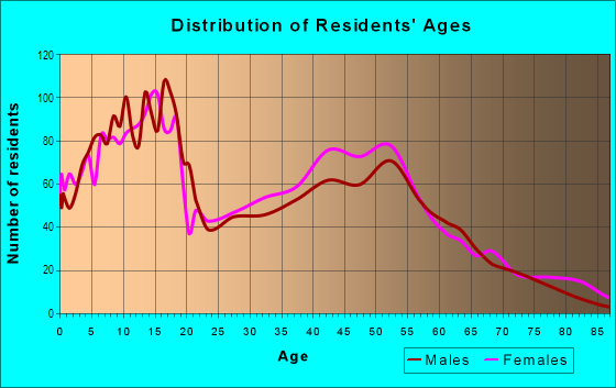
| Males: | 4,620 |
| Females: | 5,869 |
Males:
| This neighborhood: | 33.4 years |
| Whole city: | 33.4 years |
| This neighborhood: | 36.7 years |
| Whole city: | 35.2 years |
Average household size:
| Stonewood: | 5.1 people |
| Stockton: | 3.2 people |
Percentage of family households:
| Stonewood: | 55.3% |
| Stockton: | 51.0% |
| Here: | 55.3% |
| Stockton: | 42.0% |
Percentage of married-couple families with children (among all households):
| Stonewood: | 24.6% |
| Stockton: | 19.2% |
Percentage of single-mother households (among all households):
| Stonewood: | 5.6% |
| Stockton: | 9.1% |
Percentage of never married males 15 years old and over:
Percentage of never married females 15 years old and over:
| Stonewood: | 18.5% |
| Stockton: | 21.6% |
Percentage of never married females 15 years old and over:
| Stonewood: | 20.0% |
| city: | 19.3% |
Percentage of people that speak English not well or not at all:
| Stonewood: | 4.5% |
| Stockton: | 12.0% |
Percentage of people born in this state:
Percentage of people born in another U.S. state:
Percentage of native residents but born outside the U.S.:
Percentage of foreign born residents:
| Here: | 72.3% |
| Stockton: | 66.1% |
Percentage of people born in another U.S. state:
| Stonewood: | 15.2% |
| Stockton: | 7.2% |
Percentage of native residents but born outside the U.S.:
| Here: | 1.5% |
| city: | 1.5% |
Percentage of foreign born residents:
| Here: | 11.1% |
| Stockton: | 25.2% |

Owner-occupied
Renter-occupied


- Rooms in owner-occupied houses and condos in Stonewood
- 1661 room
- 02 rooms
- 763 rooms
- 1034 rooms
- 3755 rooms
- 5496 rooms
- 5017 rooms
- 2238 rooms
- 2959+ rooms

- Rooms in renter-occupied apartments in Stonewood
- 981 room
- 1032 rooms
- 2173 rooms
- 2674 rooms
- 4725 rooms
- 1006 rooms
- 1987 rooms
- 5488 rooms
- 419+ rooms
Owner-occupied
Renter-occupied

- Bedrooms in owner-occupied houses and condos in Stonewood
- 166no bedroom
- 01 bedroom
- 3752 bedrooms
- 9143 bedrooms
- 7314 bedrooms
- 1985+ bedrooms

- Bedrooms in renter-occupied apartments in Stonewood
- 136no bedroom
- 2361 bedroom
- 4342 bedrooms
- 4073 bedrooms
- 6924 bedrooms
- 315+ bedrooms
Average number of cars or other vehicles available in houses/condos:
Average number of cars or other vehicles available in apartments:
| This neighborhood: | 2.3 |
| Stockton: | 2.3 |
Average number of cars or other vehicles available in apartments:
| Here: | 2.6 |
| city: | 1.6 |
Percentage of units with a mortgage:
| Stonewood: | 61.7% |
| Stockton: | 70.5% |
Average estimated value of detached houses in 2022 (87.5% of all units):
| Stonewood: | $394,779 |
| California: | $988,808 |

- Year house built in Stonewood
- 02020 or later
- 392010 to 2019
- 3932000 to 2009
- 1961990 to 1999
- 6821980 to 1989
- 1,8641970 to 1979
- 3191960 to 1969
- 4031950 to 1959
- 1171940 to 1949
- 1971939 or earlier

City-data.com crime index for city in 2020 (higher means more crime):
| City: | 505.2 |
| U.S. average: | 219.5 |
Travel time to work (commute)
![Travel time to work (commute)]()
- 135Less than 5 minutes
- 4115 to 9 minutes
- 77610 to 14 minutes
- 1,48215 to 19 minutes
- 84020 to 24 minutes
- 17125 to 29 minutes
- 85830 to 34 minutes
- 5135 to 39 minutes
- 24040 to 44 minutes
- 33545 to 59 minutes
- 32260 to 89 minutes
- 63990 or more minutes

Means of transportation to work
![Means of transportation to work]()
- 84.3%3,136Drove a car alone
- 13.9%517Carpooled
- 0.5%19Bus
- 8.6%319Subway or elevated rail
- 1.2%44Long-distance train or commuter rail
- 3.2%118Taxi
- 2.0%74Motorcycle
- 2.3%87Bicycle
- 0.9%32Walked
- 2.9%109Other means
- 3.0%111Worked at home

Time leaving home to go to work
![Time leaving home to go to work]()
- 65412:00 a.m. to 4:59 a.m.
- 4745:00 a.m. to 5:29 a.m.
- 2555:30 a.m. to 5:59 a.m.
- 3266:00 a.m. to 6:29 a.m.
- 4266:30 a.m. to 6:59 a.m.
- 7997:00 a.m. to 7:29 a.m.
- 5107:30 a.m. to 7:59 a.m.
- 7578:00 a.m. to 8:29 a.m.
- 1828:30 a.m. to 8:59 a.m.
- 5289:00 a.m. to 9:59 a.m.
- 33110:00 a.m. to 10:59 a.m.
- 14611:00 a.m. to 11:59 a.m.
- 63812:00 p.m. to 3:59 p.m.
- 2024:00 p.m. to 11:59 p.m.

Occupations of males:
- Percentage of males in management occupations (except farmers):
Here: 10.0% city: 6.6%
- Percentage of males in business and financial operations occupations:
Here: 1.7% city: 2.1%
- Percentage of males in computer and mathematical occupations:
Here: 2.7% city: 2.1%
- Percentage of males in community and social services occupations:
Here: 3.9% city: 1.2%
- Percentage of males in legal occupations:
Here: 1.3% city: 0.3%
- Percentage of males in education, training, and library occupations:
Here: 4.8% city: 2.3%
- Percentage of males in arts, design, entertainment, sports, and media occupations:
Here: 1.4% city: 1.4%
- Percentage of males in healthcare practitioners and technical occupations:
Here: 1.7% city: 2.7%
- Percentage of males in service occupations:
Here: 11.3% city: 16.9%
- Percentage of males in sales and office occupations:
Here: 13.7% city: 13.8%
- Percentage of males in construction, extraction, and maintenance occupations:
Here: 7.8% city: 10.5%
- Percentage of males in production occupations:
Here: 15.1% city: 8.0%
- Percentage of males in transportation occupations:
Here: 8.4% city: 9.6%
- Percentage of males in material moving occupations:
Here: 11.9% city: 10.7%
Occupations of females:
- Percentage of females in management occupations (except farmers):
Here: 5.9% city: 5.9%
- Percentage of females in business and financial operations occupations:
Here: 4.7% city: 5.2%
- Percentage of females in community and social services occupations:
Here: 14.6% city: 2.9%
- Percentage of females in legal occupations:
Here: 1.0% city: 0.6%
- Percentage of females in education, training, and library occupations:
Here: 10.5% city: 7.8%
- Percentage of females in arts, design, entertainment, sports, and media occupations:
Here: 1.7% city: 0.9%
- Percentage of females in healthcare practitioners and technical occupations:
Here: 9.3% city: 8.3%
- Percentage of females in service occupations:
Here: 15.1% city: 24.4%
- Percentage of females in sales and office occupations:
Here: 35.2% city: 26.5%
- Percentage of females in production occupations:
Here: 1.3% city: 4.6%
Percentage of people 16-64 in Armed Forces:
| Stonewood: | 0.1% |
| Stockton: | 0.1% |
Education in this neighborhood (subdivision or community):
- Percentage of people 3 years and older in K-12 schools:
Stonewood: 32.1% Stockton: 20.8%
- Percentage of people 3 years and older in undergraduate colleges:
Stonewood: 9.9% Stockton: 5.2%
- Percentage of people 3 years and older in grad. or professional schools:
Stonewood: 1.4% Stockton: 1.3%
- Percentage of students K-12 enrolled in private schools:
Stonewood: 46.9% Stockton: 4.2%
Percentage of population below poverty level:
| Stonewood: | 6.5% |
| Stockton: | 14.8% |
Median year owner moved in (as recorded in 2022):
| Stonewood: | 2008 |
| Stockton: | 2011 |
Percentage of married-couple families with both working:
| Stonewood: | 74.5% |
| Stockton: | 67.8% |

- 53.3%Utility gas
- 28.2%Electricity
- 5.4%Fuel oil, kerosene, etc.
- 3.8%Bottled, tank, or LP gas
- 3.1%Solar energy
- 2.5%No fuel used
- 1.8%Wood
- 1.8%Other fuel
Roads and streets:
N Thornton Rd (Thornton Rd)
Length: 2.31 miles
Directions: E-W, SE-NW
Address range: 7700 to 9897
Directions: E-W, SE-NW
Address range: 7700 to 9897
State Hwy J10 (N Lower Sacramento Rd)
Length: 1.12 miles
Directions: N-S, SW-NE
Address range: 7600 to 9259
Directions: N-S, SW-NE
Address range: 7600 to 9259
Davis Rd
Length: 0.99 miles
Directions: N-S, SW-NE
Address range: 8600 to 9899
Directions: N-S, SW-NE
Address range: 8600 to 9899
Chaparral Way
Length: 0.98 miles
Directions: E-W, SE-NW
Address range: 1200 to 2199
Directions: E-W, SE-NW
Address range: 1200 to 2199
Royal Oaks Dr
Length: 0.63 miles
Direction: E-W
Address range: 900 to 1499
Direction: E-W
Address range: 900 to 1499
Ponce de Leon Ave
Length: 0.63 miles
Direction: E-W
Address range: 900 to 1449
Direction: E-W
Address range: 900 to 1449
Goldenoak Way
Length: 0.58 miles
Direction: E-W
Address range: 900 to 1499
Direction: E-W
Address range: 900 to 1499
Hickock Dr
Length: 0.53 miles
Directions: N-S, SW-NE
Address range: 9400 to 9874
Directions: N-S, SW-NE
Address range: 9400 to 9874
Lower Sacramento Rd
Length: 0.51 miles
Directions: N-S, SW-NE
Address range: 9260 to 9909
Directions: N-S, SW-NE
Address range: 9260 to 9909
Wagner Heights Rd
Length: 0.50 miles
Direction: E-W
Address range: 1600 to 1999
Direction: E-W
Address range: 1600 to 1999
Mac Duff Ave
Length: 0.50 miles
Directions: E-W, SW-NE
Address range: 900 to 1249
Directions: E-W, SW-NE
Address range: 900 to 1249
Princess Dr
Length: 0.45 miles
Directions: E-W, N-S, SW-NE
Address range: 900 to 1349
Directions: E-W, N-S, SW-NE
Address range: 900 to 1349
Shadow Creek Dr
Length: 0.45 miles
Directions: E-W, SE-NW, SW-NE
Address range: 900 to 1331
Directions: E-W, SE-NW, SW-NE
Address range: 900 to 1331
Stonewood Dr
Length: 0.44 miles
Directions: N-S, SW-NE
Address range: 8600 to 9299
Directions: N-S, SW-NE
Address range: 8600 to 9299
Estate Dr
Length: 0.41 miles
Directions: E-W, SW-NE
Address range: 2200 to 2499
Directions: E-W, SW-NE
Address range: 2200 to 2499
Cody Way
Length: 0.39 miles
Directions: N-S, SE-NW, SW-NE
Address range: 9400 to 9899
Directions: N-S, SE-NW, SW-NE
Address range: 9400 to 9899
Encino Ave
Length: 0.38 miles
Directions: E-W, N-S, SE-NW, SW-NE
Address range: 8000 to 8399
Directions: E-W, N-S, SE-NW, SW-NE
Address range: 8000 to 8399
Sunnyoak Way
Length: 0.37 miles
Direction: E-W
Address range: 900 to 1199
Direction: E-W
Address range: 900 to 1199
Graywood Cir
Length: 0.37 miles
Directions: E-W, N-S, SE-NW, SW-NE
Address range: 900 to 1146
Directions: E-W, N-S, SE-NW, SW-NE
Address range: 900 to 1146
Paloma Ave
Length: 0.36 miles
Direction: E-W
Address range: 900 to 1299
Direction: E-W
Address range: 900 to 1299
Laredo Cir
Length: 0.35 miles
Directions: E-W, N-S, SE-NW, SW-NE
Address range: 1821 to 1968
Directions: E-W, N-S, SE-NW, SW-NE
Address range: 1821 to 1968
Santa Fe Dr
Length: 0.34 miles
Directions: E-W, SE-NW
Address range: 1700 to 1977
Directions: E-W, SE-NW
Address range: 1700 to 1977
Pecos Cir
Length: 0.33 miles
Directions: E-W, N-S, SE-NW, SW-NE
Address range: 1500 to 1799
Directions: E-W, N-S, SE-NW, SW-NE
Address range: 1500 to 1799
Pawnee Way
Length: 0.32 miles
Direction: E-W
Address range: 1900 to 2066
Direction: E-W
Address range: 1900 to 2066
Oakleaf Way
Length: 0.32 miles
Direction: E-W
Address range: 900 to 1149
Direction: E-W
Address range: 900 to 1149
Bear Creek Way
Length: 0.32 miles
Directions: E-W, SE-NW, SW-NE
Address range: 900 to 1149
Directions: E-W, SE-NW, SW-NE
Address range: 900 to 1149
Broadridge Way
Length: 0.31 miles
Directions: E-W, N-S, SW-NE
Address range: 2250 to 9844
Directions: E-W, N-S, SW-NE
Address range: 2250 to 9844
Briarwood Way
Length: 0.31 miles
Directions: E-W, N-S, SE-NW, SW-NE
Address range: 1200 to 1449
Directions: E-W, N-S, SE-NW, SW-NE
Address range: 1200 to 1449
Springoak Way
Length: 0.30 miles
Directions: E-W, N-S, SE-NW
Address range: 900 to 1099
Directions: E-W, N-S, SE-NW
Address range: 900 to 1099
Comstock Dr
Length: 0.30 miles
Direction: E-W
Address range: 1900 to 2068
Direction: E-W
Address range: 1900 to 2068
Oakhurst Way
Length: 0.30 miles
Direction: E-W
Address range: 900 to 1149
Direction: E-W
Address range: 900 to 1149
Cheyenne Way
Length: 0.29 miles
Directions: E-W, SE-NW
Address range: 1800 to 1979
Directions: E-W, SE-NW
Address range: 1800 to 1979
Waudman Ave
Length: 0.29 miles
Directions: E-W, N-S, SW-NE
Address range: 1600 to 1899
Directions: E-W, N-S, SW-NE
Address range: 1600 to 1899
Bowie Way
Length: 0.29 miles
Directions: E-W, N-S, SW-NE
Address range: 9601 to 9822
Directions: E-W, N-S, SW-NE
Address range: 9601 to 9822
Goldenleaf Way
Length: 0.29 miles
Directions: E-W, N-S, SE-NW
Address range: 1200 to 1499
Directions: E-W, N-S, SE-NW
Address range: 1200 to 1499
Colt Dr
Length: 0.29 miles
Directions: E-W, SW-NE
Address range: 1900 to 2071
Directions: E-W, SW-NE
Address range: 1900 to 2071
Chelsea Way
Length: 0.28 miles
Directions: E-W, SW-NE
Address range: 1200 to 1499
Directions: E-W, SW-NE
Address range: 1200 to 1499
Laramie Way
Length: 0.27 miles
Direction: E-W
Address range: 1600 to 1799
Direction: E-W
Address range: 1600 to 1799
el Camino Ave
Length: 0.26 miles
Directions: E-W, SW-NE
Address range: 900 to 1099
Directions: E-W, SW-NE
Address range: 900 to 1099
Woodcreek Way
Length: 0.26 miles
Directions: E-W, SW-NE
Address range: 1200 to 1499
Directions: E-W, SW-NE
Address range: 1200 to 1499
Enchantment Ln
Length: 0.25 miles
Directions: N-S, SE-NW
Address range: 9500 to 9730
Directions: N-S, SE-NW
Address range: 9500 to 9730
Majestic Ln
Length: 0.25 miles
Directions: N-S, SW-NE
Address range: 9500 to 9729
Directions: N-S, SW-NE
Address range: 9500 to 9729
Valleyoak Dr
Length: 0.25 miles
Directions: N-S, SE-NW, SW-NE
Address range: 8800 to 9299
Directions: N-S, SE-NW, SW-NE
Address range: 8800 to 9299
Coach St
Length: 0.24 miles
Directions: E-W, SE-NW, SW-NE
Address range: 900 to 1141
Directions: E-W, SE-NW, SW-NE
Address range: 900 to 1141
Aberdeen Ave
Length: 0.24 miles
Directions: E-W, SW-NE
Address range: 1100 to 1349
Directions: E-W, SW-NE
Address range: 1100 to 1349
Armor Dr
Length: 0.22 miles
Direction: E-W
Address range: 917 to 1047
Direction: E-W
Address range: 917 to 1047
Knight Ln
Length: 0.20 miles
Direction: N-S
Address range: 9500 to 9641
Direction: N-S
Address range: 9500 to 9641
Navajo Dr
Length: 0.20 miles
Direction: E-W
Address range: 1600 to 1799
Direction: E-W
Address range: 1600 to 1799
Earth Flower Dr
Length: 0.20 miles
Directions: E-W, SW-NE
Address range: 1201 to 1349
Directions: E-W, SW-NE
Address range: 1201 to 1349
Duchess Ln
Length: 0.20 miles
Direction: N-S
Address range: 9524 to 9636
Direction: N-S
Address range: 9524 to 9636
Woodmont Way
Length: 0.19 miles
Directions: E-W, SE-NW
Address range: 1300 to 1449
Directions: E-W, SE-NW
Address range: 1300 to 1449
Chisholm Way
Length: 0.19 miles
Direction: N-S
Address range: 9400 to 9599
Direction: N-S
Address range: 9400 to 9599
Connie Ave
Length: 0.18 miles
Directions: E-W, SE-NW, SW-NE
Address range: 9100 to 9199
Directions: E-W, SE-NW, SW-NE
Address range: 9100 to 9199
Nantucket Dr
Length: 0.18 miles
Directions: N-S, SW-NE
Address range: 9500 to 9799
Directions: N-S, SW-NE
Address range: 9500 to 9799
Wyatt Way
Length: 0.18 miles
Direction: E-W
Address range: 1600 to 1799
Direction: E-W
Address range: 1600 to 1799
Friar St
Length: 0.18 miles
Direction: E-W
Address range: 1000 to 1045
Direction: E-W
Address range: 1000 to 1045
Candlewood Way
Length: 0.17 miles
Direction: E-W
Address range: 1300 to 1449
Direction: E-W
Address range: 1300 to 1449
Bonanza Dr
Length: 0.17 miles
Direction: N-S
Address range: 9400 to 9545
Direction: N-S
Address range: 9400 to 9545
Tarbat St
Length: 0.16 miles
Direction: N-S
Address range: 8200 to 8449
Direction: N-S
Address range: 8200 to 8449
Katherine Way
Length: 0.15 miles
Direction: E-W
Address range: 900 to 1035
Direction: E-W
Address range: 900 to 1035
W Hammer Ln (State Hwy J8)
Length: 0.14 miles
Direction: E-W
Address range: 900 to 1099
Direction: E-W
Address range: 900 to 1099
Roxburgh Way
Length: 0.13 miles
Directions: N-S, SE-NW
Address range: 8400 to 8449
Directions: N-S, SE-NW
Address range: 8400 to 8449
Burns Way
Length: 0.13 miles
Directions: E-W, SE-NW
Address range: 1000 to 1049
Directions: E-W, SE-NW
Address range: 1000 to 1049
Havenhill Way
Length: 0.12 miles
Directions: E-W, SE-NW
Address range: 1200 to 1324
Directions: E-W, SE-NW
Address range: 1200 to 1324
Weeping Willow Dr
Length: 0.12 miles
Directions: N-S, SW-NE
Address range: 9800 to 9887
Directions: N-S, SW-NE
Address range: 9800 to 9887
Burns Pl
Length: 0.11 miles
Directions: N-S, SE-NW
Address range: 8400 to 8599
Directions: N-S, SE-NW
Address range: 8400 to 8599
Honey Bear Ln
Length: 0.11 miles
Directions: N-S, SW-NE
Address range: 9800 to 9899
Directions: N-S, SW-NE
Address range: 9800 to 9899
Rothesay Pl
Length: 0.11 miles
Directions: N-S, SE-NW
Address range: 8300 to 8499
Directions: N-S, SE-NW
Address range: 8300 to 8499
Ravenwood Dr
Length: 0.11 miles
Directions: N-S, SE-NW
Address range: 8700 to 8849
Directions: N-S, SE-NW
Address range: 8700 to 8849
Cobblestone Dr
Length: 0.11 miles
Directions: N-S, SE-NW, SW-NE
Address range: 9800 to 9836
Directions: N-S, SE-NW, SW-NE
Address range: 9800 to 9836
Littleoaks Way
Length: 0.10 miles
Directions: N-S, SE-NW
Address range: 8800 to 8899
Directions: N-S, SE-NW
Address range: 8800 to 8899
Glenbriar Dr
Length: 0.10 miles
Direction: N-S
Address range: 8700 to 8799
Direction: N-S
Address range: 8700 to 8799
Barcelona Ave
Length: 0.09 miles
Direction: E-W
Address range: 1300 to 1399
Direction: E-W
Address range: 1300 to 1399
N Pershing Ave
Length: 0.09 miles
Directions: N-S, SW-NE
Address range: 8300 to 8399
Directions: N-S, SW-NE
Address range: 8300 to 8399
Hickock Ct
Length: 0.09 miles
Direction: E-W
Address range: 1900 to 1961
Direction: E-W
Address range: 1900 to 1961
Woodglen Ct
Length: 0.08 miles
Directions: E-W, SW-NE
Address range: 1000 to 1059
Directions: E-W, SW-NE
Address range: 1000 to 1059
Shady Oaks Dr
Length: 0.08 miles
Directions: N-S, SW-NE
Address range: 9800 to 9855
Directions: N-S, SW-NE
Address range: 9800 to 9855
Overland Pl
Length: 0.08 miles
Direction: N-S
Address range: 9800 to 9859
Direction: N-S
Address range: 9800 to 9859
Fairhaven Dr
Length: 0.08 miles
Directions: N-S, SE-NW, SW-NE
Address range: 9500 to 9560
Directions: N-S, SE-NW, SW-NE
Address range: 9500 to 9560
Amanda Ct
Length: 0.07 miles
Direction: E-W
Address range: 1600 to 1656
Direction: E-W
Address range: 1600 to 1656
Laredo Ct
Length: 0.07 miles
Directions: E-W, SE-NW
Address range: 1900 to 1946
Directions: E-W, SE-NW
Address range: 1900 to 1946
Squire Ln
Length: 0.07 miles
Direction: N-S
Address range: 9400 to 9499
Direction: N-S
Address range: 9400 to 9499
Koala Ct
Length: 0.07 miles
Directions: N-S, SW-NE
Address range: 9800 to 9849
Directions: N-S, SW-NE
Address range: 9800 to 9849
Stacey Ct
Length: 0.07 miles
Direction: SE-NW
Address range: 9000 to 9053
Direction: SE-NW
Address range: 9000 to 9053
Laramie Ct
Length: 0.06 miles
Direction: N-S
Address range: 9600 to 9639
Direction: N-S
Address range: 9600 to 9639
Sherill Ct
Length: 0.06 miles
Directions: E-W, SE-NW
Address range: 9000 to 9099
Directions: E-W, SE-NW
Address range: 9000 to 9099
Gentle Ben Ct
Length: 0.06 miles
Directions: N-S, SE-NW
Address range: 9800 to 9899
Directions: N-S, SE-NW
Address range: 9800 to 9899
Single Tree Ct
Length: 0.06 miles
Directions: N-S, SE-NW
Address range: 9300 to 9399
Directions: N-S, SE-NW
Address range: 9300 to 9399
Mac Duff Ct
Length: 0.06 miles
Directions: N-S, SE-NW
Address range: 8400 to 8549
Directions: N-S, SE-NW
Address range: 8400 to 8549
Duke Ln
Length: 0.06 miles
Direction: N-S
Address range: 9400 to 9499
Direction: N-S
Address range: 9400 to 9499
Shawnee Ct
Length: 0.06 miles
Directions: N-S, SW-NE
Address range: 9400 to 9451
Directions: N-S, SW-NE
Address range: 9400 to 9451
Royal Park Ln
Length: 0.06 miles
Directions: N-S, SE-NW
Address range: 9400 to 9499
Directions: N-S, SE-NW
Address range: 9400 to 9499
Shadow Creek Ct
Length: 0.06 miles
Directions: N-S, SE-NW
Address range: 9800 to 9832
Directions: N-S, SE-NW
Address range: 9800 to 9832
Chattan Ct
Length: 0.05 miles
Direction: N-S
Address range: 8400 to 8449
Direction: N-S
Address range: 8400 to 8449
Smokey Ct
Length: 0.05 miles
Directions: N-S, SW-NE
Address range: 9801 to 9872
Directions: N-S, SW-NE
Address range: 9801 to 9872
Hamlet Ct
Length: 0.05 miles
Direction: E-W
Address range: 1000 to 1099
Direction: E-W
Address range: 1000 to 1099
Earl Ct
Length: 0.05 miles
Direction: E-W
Address range: 1013 to 1047
Direction: E-W
Address range: 1013 to 1047
Bridgewood Ct
Length: 0.05 miles
Directions: N-S, SE-NW
Address range: 9000 to 9099
Directions: N-S, SE-NW
Address range: 9000 to 9099
Woodcreek Ct
Length: 0.05 miles
Directions: N-S, SW-NE
Address range: 9000 to 9099
Directions: N-S, SW-NE
Address range: 9000 to 9099
Cody Ct
Length: 0.04 miles
Direction: E-W
Address range: 2100 to 2123
Direction: E-W
Address range: 2100 to 2123
Kernwood Ct
Length: 0.04 miles
Direction: N-S
Address range: 8600 to 8699
Direction: N-S
Address range: 8600 to 8699
Chester Ct
Length: 0.04 miles
Direction: E-W
Address range: 2100 to 2199
Direction: E-W
Address range: 2100 to 2199
Pueblo Ct
Length: 0.04 miles
Direction: N-S
Address range: 9400 to 9451
Direction: N-S
Address range: 9400 to 9451
Oak Knoll Ct
Length: 0.04 miles
Direction: N-S
Address range: 8700 to 8769
Direction: N-S
Address range: 8700 to 8769
Eastwood Ct
Length: 0.04 miles
Direction: N-S
Address range: 8700 to 8769
Direction: N-S
Address range: 8700 to 8769
Chaparral Ct
Length: 0.03 miles
Directions: N-S, SE-NW
Address range: 9700 to 9799
Directions: N-S, SE-NW
Address range: 9700 to 9799
Powder Ct
Length: 0.03 miles
Directions: N-S, SE-NW
Address range: 9300 to 9332
Directions: N-S, SE-NW
Address range: 9300 to 9332
Graywood Ct
Length: 0.03 miles
Direction: N-S
Address range: 8600 to 8635
Direction: N-S
Address range: 8600 to 8635
Otto Dr
Length: 0.03 miles
Direction: SW-NE
Direction: SW-NE
Stanfield Dr
Length: 0.03 miles
Direction: SW-NE
Address range: 2200 to 2209
Direction: SW-NE
Address range: 2200 to 2209
Pacific Ave
Length: 0.01 miles
Direction: SE-NW
Direction: SE-NW