Stoney Road neighborhood in Paterson, New Jersey (NJ), 07501, 07505 detailed profile
Settings
X


Business Search - 14 Million verified businesses
Area: 0.985 square miles
Population: 15,997
Population density:
| Stoney Road: | 16,245 people per square mile |
| Paterson: | 18,554 people per square mile |

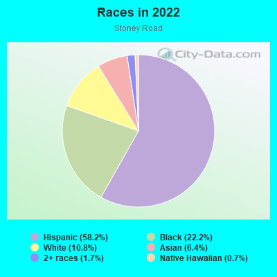
- 9,74058.2%Hispanic or Latino
- 3,70922.2%Black
- 1,80910.8%White
- 1,0686.4%Asian
- 2851.7%Two or more races
- 1180.7%Native Hawaiian and Other
Pacific Islander
Distribution of median household income
![Distribution of median household income]()
- 685Less than $10,000
- 1,478$10,000 to $19,999
- 624$20,000 to $29,999
- 1,042$30,000 to $39,999
- 872$40,000 to $49,999
- 405$50,000 to $59,999
- 490$60,000 to $74,999
- 553$75,000 to $99,999
- 327$100,000 to $124,999
- 358$125,000 to $149,999
- 429$150,000 to $199,999
- 269$200,000 or more

Distribution of owner-occupied house/condo value
![Distribution of owner-occupied house/condo value]()
- 866Less than $50,000
- 581$50,000 to $99,999
- 728$100,000 to $149,999
- 405$150,000 to $199,999
- 632$200,000 to $249,999
- 677$250,000 to $299,999
- 407$300,000 to $399,999
- 230$400,000 to $499,999
- 62$500,000 to $749,999
- 33$750,000 to $999,999
- 119$1,000,000 or more

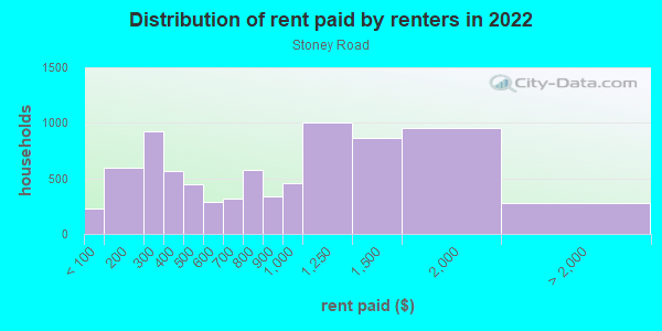
Distribution of rent paid by renters
![Distribution of rent paid by renters]()
- 230Less than $100
- 597$100 to $199
- 922$200 to $299
- 562$300 to $399
- 449$400 to $499
- 285$500 to $599
- 314$600 to $699
- 575$700 to $799
- 341$800 to $899
- 460$900 to $999
- 1,001$1,000 to $1,249
- 862$1,250 to $1,499
- 956$1,500 to $1,999
- 277$2,000 or more
Median rent in 2022:
| Stoney Road: | $1,073 |
| Paterson: | $1,227 |
| Males: | 8,079 |
| Females: | 7,917 |
Males:
| This neighborhood: | 32.2 years |
| Whole city: | 33.1 years |
| This neighborhood: | 34.3 years |
| Whole city: | 33.3 years |
Average household size:
| Stoney Road: | 7.2 people |
| Paterson: | 3.1 people |
Percentage of family households:
| Stoney Road: | 50.0% |
| Paterson: | 48.8% |
| Here: | 27.1% |
| Paterson: | 31.0% |
Percentage of married-couple families with children (among all households):
| Stoney Road: | 14.2% |
| Paterson: | 16.3% |
Percentage of single-mother households (among all households):
| Stoney Road: | 21.0% |
| Paterson: | 13.4% |
Percentage of never married males 15 years old and over:
Percentage of never married females 15 years old and over:
| Stoney Road: | 29.4% |
| Paterson: | 24.4% |
Percentage of never married females 15 years old and over:
| Stoney Road: | 24.6% |
| city: | 24.1% |
Percentage of people that speak English not well or not at all:
| Stoney Road: | 25.4% |
| Paterson: | 24.5% |
Percentage of people born in this state:
Percentage of people born in another U.S. state:
Percentage of native residents but born outside the U.S.:
Percentage of foreign born residents:
| Here: | 45.7% |
| Paterson: | 42.9% |
Percentage of people born in another U.S. state:
| Stoney Road: | 8.2% |
| Paterson: | 11.0% |
Percentage of native residents but born outside the U.S.:
| Here: | 7.6% |
| city: | 4.8% |
Percentage of foreign born residents:
| Here: | 38.5% |
| Paterson: | 41.3% |
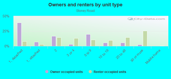
Owner-occupied
Renter-occupied

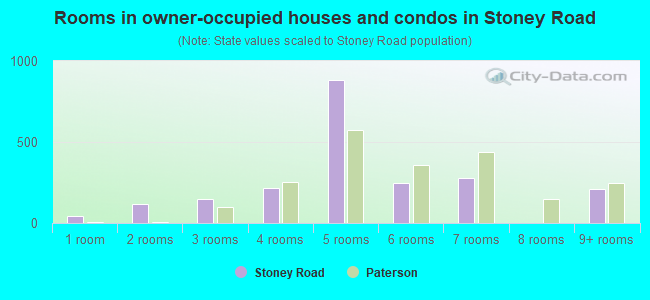
- Rooms in owner-occupied houses and condos in Stoney Road
- 441 room
- 1182 rooms
- 1493 rooms
- 2134 rooms
- 8825 rooms
- 2446 rooms
- 2797 rooms
- 08 rooms
- 2079+ rooms
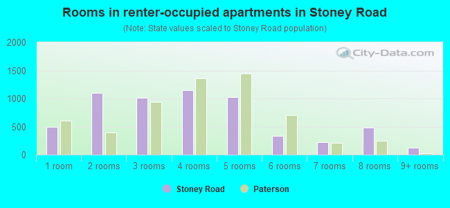
- Rooms in renter-occupied apartments in Stoney Road
- 4921 room
- 1,0932 rooms
- 1,0073 rooms
- 1,1434 rooms
- 1,0215 rooms
- 3366 rooms
- 2217 rooms
- 4808 rooms
- 1229+ rooms
Owner-occupied
Renter-occupied
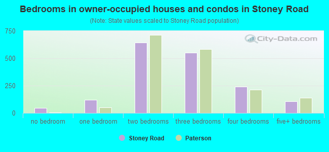
- Bedrooms in owner-occupied houses and condos in Stoney Road
- 44no bedroom
- 1191 bedroom
- 6442 bedrooms
- 5523 bedrooms
- 2404 bedrooms
- 1065+ bedrooms
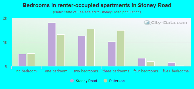
- Bedrooms in renter-occupied apartments in Stoney Road
- 507no bedroom
- 1,8171 bedroom
- 1,2662 bedrooms
- 1,0223 bedrooms
- 3334 bedrooms
- 1575+ bedrooms
Average number of cars or other vehicles available in houses/condos:
Average number of cars or other vehicles available in apartments:
| This neighborhood: | |
| Paterson: |
Average number of cars or other vehicles available in apartments:
| Here: | 0.6 |
| city: | 0.9 |
Percentage of units with a mortgage:
| Stoney Road: | 59.7% |
| Paterson: | 67.2% |
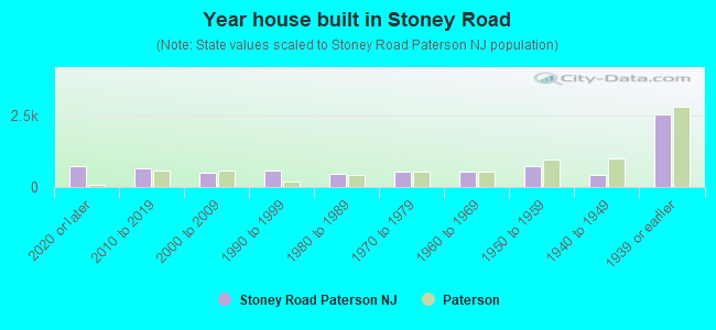
- Year house built in Stoney Road
- 7092020 or later
- 6312010 to 2019
- 4952000 to 2009
- 5701990 to 1999
- 4691980 to 1989
- 5381970 to 1979
- 5311960 to 1969
- 7211950 to 1959
- 4341940 to 1949
- 2,5111939 or earlier
City-data.com crime index for city in 2020 (higher means more crime):
| City: | 359.6 |
| U.S. average: | 219.5 |
Travel time to work (commute)
![Travel time to work (commute)]()
- 145Less than 5 minutes
- 3275 to 9 minutes
- 1,10110 to 14 minutes
- 87415 to 19 minutes
- 82820 to 24 minutes
- 54225 to 29 minutes
- 68430 to 34 minutes
- 10435 to 39 minutes
- 10240 to 44 minutes
- 36545 to 59 minutes
- 16760 to 89 minutes
- 10190 or more minutes

Means of transportation to work
![Means of transportation to work]()
- 54.9%3,116Drove a car alone
- 22.7%1,292Carpooled
- 13.4%762Bus
- 83.3%4,732Subway or elevated rail
- 3.8%218Long-distance train or commuter rail
- 15.1%858Light rail, streetcar or trolley
- 3.2%183Taxi
- 24.6%1,395Walked
- 2.1%118Other means
- 4.9%276Worked at home

Time leaving home to go to work
![Time leaving home to go to work]()
- 14212:00 a.m. to 4:59 a.m.
- 1955:00 a.m. to 5:29 a.m.
- 2425:30 a.m. to 5:59 a.m.
- 4246:00 a.m. to 6:29 a.m.
- 7446:30 a.m. to 6:59 a.m.
- 6407:00 a.m. to 7:29 a.m.
- 3167:30 a.m. to 7:59 a.m.
- 1,1348:00 a.m. to 8:29 a.m.
- 3578:30 a.m. to 8:59 a.m.
- 2399:00 a.m. to 9:59 a.m.
- 17110:00 a.m. to 10:59 a.m.
- 9311:00 a.m. to 11:59 a.m.
- 29112:00 p.m. to 3:59 p.m.
- 2044:00 p.m. to 11:59 p.m.

Occupations of males:
- Percentage of males in management occupations (except farmers):
Here: 4.8% city: 5.2%
- Percentage of males in computer and mathematical occupations:
Here: 1.8% city: 2.0%
- Percentage of males in service occupations:
Here: 22.0% city: 17.1%
- Percentage of males in sales and office occupations:
Here: 11.1% city: 15.3%
- Percentage of males in construction, extraction, and maintenance occupations:
Here: 12.6% city: 10.5%
- Percentage of males in production occupations:
Here: 23.9% city: 14.8%
- Percentage of males in transportation occupations:
Here: 11.9% city: 12.6%
- Percentage of males in material moving occupations:
Here: 5.5% city: 10.2%
Occupations of females:
- Percentage of females in management occupations (except farmers):
Here: 5.8% city: 4.3%
- Percentage of females in business and financial operations occupations:
Here: 1.7% city: 2.2%
- Percentage of females in education, training, and library occupations:
Here: 2.5% city: 5.1%
- Percentage of females in healthcare practitioners and technical occupations:
Here: 8.9% city: 5.0%
- Percentage of females in service occupations:
Here: 28.8% city: 29.3%
- Percentage of females in sales and office occupations:
Here: 30.3% city: 28.3%
- Percentage of females in production occupations:
Here: 15.7% city: 11.3%
- Percentage of females in transportation occupations:
Here: 1.3% city: 3.0%
- Percentage of females in material moving occupations:
Here: 3.4% city: 6.1%
Education in this neighborhood (subdivision or community):
- Percentage of people 3 years and older in K-12 schools:
Stoney Road: 33.0% Paterson: 21.2%
- Percentage of people 3 years and older in undergraduate colleges:
Stoney Road: 4.0% Paterson: 5.7%
- Percentage of people 3 years and older in grad. or professional schools:
Stoney Road: 1.7% Paterson: 0.6%
- Percentage of students K-12 enrolled in private schools:
Stoney Road: 25.9% Paterson: 2.9%
Percentage of population below poverty level:
| Stoney Road: | 34.3% |
| Paterson: | 21.1% |
Median year renter moved in (as recorded in 2022):
| Stoney Road: | 2015 |
| Paterson: | 2017 |
Percentage of married-couple families with both working:
| Stoney Road: | 98.3% |
| Paterson: | 39.8% |
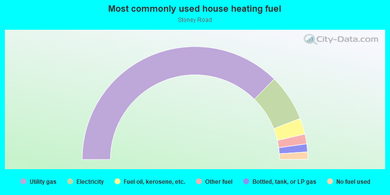
- 74.7%Utility gas
- 13.4%Electricity
- 4.6%Fuel oil, kerosene, etc.
- 2.8%Other fuel
- 2.3%Bottled, tank, or LP gas
- 2.1%No fuel used
Limited-access highways (interstate or state) in this neighborhood:
I- 80
Length: 2.56 miles
Directions: E-W, SW-NE
Directions: E-W, SW-NE
Highways in this neighborhood:
State Rte 19
Length: 1.23 miles
Directions: E-W, N-S, SE-NW, SW-NE
Address range: 139 to 175
Directions: E-W, N-S, SE-NW, SW-NE
Address range: 139 to 175
Main St (State Rte 509)
Length: 1.04 miles
Directions: N-S, SE-NW
Address range: 1 to 522
Directions: N-S, SE-NW
Address range: 1 to 522
Roads and streets:
Grand St
Length: 1.32 miles
Direction: E-W
Address range: 41 to 475
Direction: E-W
Address range: 41 to 475
Market St
Length: 0.93 miles
Directions: E-W, SE-NW, SW-NE
Address range: 1 to 289
Directions: E-W, SE-NW, SW-NE
Address range: 1 to 289
Passaic County 639 (McBride Ave)
Length: 0.87 miles
Directions: E-W, SW-NE
Address range: 152 to 462
Directions: E-W, SW-NE
Address range: 152 to 462
Ellison St
Length: 0.80 miles
Directions: E-W, SW-NE
Address range: 1 to 258
Directions: E-W, SW-NE
Address range: 1 to 258
River St
Length: 0.77 miles
Directions: E-W, N-S, SW-NE
Address range: 1 to 243
Directions: E-W, N-S, SW-NE
Address range: 1 to 243
Straight St (Passaic County 647)
Length: 0.74 miles
Directions: N-S, SW-NE
Address range: 1 to 257
Directions: N-S, SW-NE
Address range: 1 to 257
Mill St
Length: 0.74 miles
Directions: E-W, N-S, SE-NW, SW-NE
Address range: 1 to 299
Directions: E-W, N-S, SE-NW, SW-NE
Address range: 1 to 299
Memorial Dr
Length: 0.73 miles
Directions: E-W, N-S, SE-NW
Address range: 58 to 232
Directions: E-W, N-S, SE-NW
Address range: 58 to 232
Dr Martin Luther King Fwy (Broadway)
Length: 0.64 miles
Direction: E-W
Address range: 1 to 239
Direction: E-W
Address range: 1 to 239
Ward St
Length: 0.63 miles
Directions: E-W, SW-NE
Address range: 1 to 208
Directions: E-W, SW-NE
Address range: 1 to 208
College Blvd (Van Houten St)
Length: 0.63 miles
Directions: E-W, SW-NE
Address range: 1 to 230
Directions: E-W, SW-NE
Address range: 1 to 230
Slater St
Length: 0.60 miles
Directions: E-W, SE-NW, SW-NE
Address range: 1 to 272
Directions: E-W, SE-NW, SW-NE
Address range: 1 to 272
Caldwell Ave
Length: 0.57 miles
Directions: E-W, SE-NW
Address range: 64 to 267
Directions: E-W, SE-NW
Address range: 64 to 267
Railroad Ave
Length: 0.54 miles
Directions: N-S, SE-NW
Address range: 22 to 233
Directions: N-S, SE-NW
Address range: 22 to 233
Marshall St
Length: 0.48 miles
Directions: N-S, SE-NW
Address range: 1 to 140
Directions: N-S, SE-NW
Address range: 1 to 140
Carlisle Ave
Length: 0.47 miles
Direction: E-W
Address range: 40 to 212
Direction: E-W
Address range: 40 to 212
Dixon Ave
Length: 0.46 miles
Direction: E-W
Address range: 50 to 199
Direction: E-W
Address range: 50 to 199
Danforth Ave
Length: 0.41 miles
Direction: E-W
Address range: 20 to 158
Direction: E-W
Address range: 20 to 158
Spruce St
Length: 0.41 miles
Directions: N-S, SE-NW, SW-NE
Address range: 1 to 156
Directions: N-S, SE-NW, SW-NE
Address range: 1 to 156
Webster Ave
Length: 0.37 miles
Direction: E-W
Address range: 1 to 199
Direction: E-W
Address range: 1 to 199
Barnes St
Length: 0.36 miles
Directions: E-W, SW-NE
Address range: 1 to 12
Directions: E-W, SW-NE
Address range: 1 to 12
Paterson St
Length: 0.35 miles
Direction: N-S
Address range: 1 to 138
Direction: N-S
Address range: 1 to 138
Murray Ave
Length: 0.34 miles
Directions: E-W, SE-NW
Address range: 2 to 132
Directions: E-W, SE-NW
Address range: 2 to 132
Cross St (Cianci St)
Length: 0.33 miles
Directions: N-S, SE-NW
Address range: 1 to 107
Directions: N-S, SE-NW
Address range: 1 to 107
Dale Ave
Length: 0.33 miles
Direction: N-S
Address range: 1 to 135
Direction: N-S
Address range: 1 to 135
Rockland St
Length: 0.30 miles
Directions: N-S, SW-NE
Address range: 1 to 112
Directions: N-S, SW-NE
Address range: 1 to 112
Prince St
Length: 0.30 miles
Direction: N-S
Address range: 31 to 161
Direction: N-S
Address range: 31 to 161
Spring St
Length: 0.29 miles
Direction: SE-NW
Address range: 1 to 155
Direction: SE-NW
Address range: 1 to 155
Hamilton St
Length: 0.28 miles
Directions: N-S, SE-NW
Address range: 2 to 40
Directions: N-S, SE-NW
Address range: 2 to 40
Washington St
Length: 0.27 miles
Directions: N-S, SE-NW, SW-NE
Address range: 1 to 198
Directions: N-S, SE-NW, SW-NE
Address range: 1 to 198
20th Ave
Length: 0.27 miles
Directions: E-W, SE-NW
Address range: 1 to 70
Directions: E-W, SE-NW
Address range: 1 to 70
Jersey St
Length: 0.27 miles
Direction: SE-NW
Address range: 2 to 109
Direction: SE-NW
Address range: 2 to 109
Nagle St
Length: 0.27 miles
Direction: SW-NE
Address range: 45 to 131
Direction: SW-NE
Address range: 45 to 131
Jackson St
Length: 0.26 miles
Direction: SE-NW
Address range: 1 to 145
Direction: SE-NW
Address range: 1 to 145
Tyler St
Length: 0.26 miles
Directions: E-W, SE-NW
Address range: 1 to 80
Directions: E-W, SE-NW
Address range: 1 to 80
Ramsey St
Length: 0.26 miles
Directions: E-W, N-S, SW-NE
Address range: 100 to 199
Directions: E-W, N-S, SW-NE
Address range: 100 to 199
Governor St
Length: 0.25 miles
Direction: E-W
Address range: 1 to 75
Direction: E-W
Address range: 1 to 75
Green St
Length: 0.24 miles
Direction: E-W
Address range: 1 to 61
Direction: E-W
Address range: 1 to 61
Bridge St
Length: 0.24 miles
Directions: N-S, SE-NW, SW-NE
Address range: 1 to 99
Directions: N-S, SE-NW, SW-NE
Address range: 1 to 99
McBride Ave Exd
Length: 0.23 miles
Directions: E-W, SE-NW, SW-NE
Address range: 1 to 93
Directions: E-W, SE-NW, SW-NE
Address range: 1 to 93
Oliver St
Length: 0.22 miles
Directions: E-W, SW-NE
Address range: 2 to 298
Directions: E-W, SW-NE
Address range: 2 to 298
Crosby Pl
Length: 0.22 miles
Direction: N-S
Address range: 1 to 15
Direction: N-S
Address range: 1 to 15
Curtis Pl
Length: 0.21 miles
Directions: N-S, SE-NW
Address range: 1 to 54
Directions: N-S, SE-NW
Address range: 1 to 54
Van Houten St
Length: 0.21 miles
Directions: E-W, N-S, SW-NE
Address range: 1 to 78
Directions: E-W, N-S, SW-NE
Address range: 1 to 78
W Broadway
Length: 0.20 miles
Directions: E-W, SE-NW
Address range: 1 to 64
Directions: E-W, SE-NW
Address range: 1 to 64
Tony Columbia Pl (Fair St)
Length: 0.19 miles
Direction: E-W
Address range: 1 to 144
Direction: E-W
Address range: 1 to 144
Smith St
Length: 0.19 miles
Direction: E-W
Address range: 1 to 61
Direction: E-W
Address range: 1 to 61
Fulton St
Length: 0.19 miles
Direction: E-W
Address range: 1 to 56
Direction: E-W
Address range: 1 to 56
Church St
Length: 0.18 miles
Direction: N-S
Address range: 1 to 64
Direction: N-S
Address range: 1 to 64
Prospect St
Length: 0.18 miles
Directions: N-S, SE-NW
Address range: 66 to 109
Directions: N-S, SE-NW
Address range: 66 to 109
Clark St
Length: 0.18 miles
Directions: N-S, SE-NW, SW-NE
Address range: 48 to 62
Directions: N-S, SE-NW, SW-NE
Address range: 48 to 62
New St
Length: 0.18 miles
Directions: N-S, SW-NE
Address range: 1 to 98
Directions: N-S, SW-NE
Address range: 1 to 98
Reservoir Ave (Reservoir St)
Length: 0.17 miles
Direction: N-S
Direction: N-S
de Grasse St
Length: 0.16 miles
Directions: E-W, SE-NW
Address range: 9 to 73
Directions: E-W, SE-NW
Address range: 9 to 73
Quinn St
Length: 0.16 miles
Direction: N-S
Address range: 1 to 66
Direction: N-S
Address range: 1 to 66
Elm St
Length: 0.14 miles
Direction: E-W
Address range: 1 to 99
Direction: E-W
Address range: 1 to 99
Hamilton Ave
Length: 0.14 miles
Direction: E-W
Address range: 85 to 130
Direction: E-W
Address range: 85 to 130
Passaic St
Length: 0.14 miles
Direction: E-W
Address range: 1 to 99
Direction: E-W
Address range: 1 to 99
21st Ave
Length: 0.14 miles
Direction: E-W
Address range: 17 to 163
Direction: E-W
Address range: 17 to 163
Hoxey St
Length: 0.13 miles
Direction: N-S
Address range: 1 to 69
Direction: N-S
Address range: 1 to 69
Dayton St
Length: 0.13 miles
Directions: N-S, SW-NE
Address range: 41 to 63
Directions: N-S, SW-NE
Address range: 41 to 63
Godwin St
Length: 0.13 miles
Direction: E-W
Address range: 2 to 61
Direction: E-W
Address range: 2 to 61
Lawrence St
Length: 0.12 miles
Direction: E-W
Address range: 13 to 50
Direction: E-W
Address range: 13 to 50
Henderson St
Length: 0.12 miles
Direction: N-S
Address range: 30 to 67
Direction: N-S
Address range: 30 to 67
Harrison St
Length: 0.11 miles
Direction: E-W
Direction: E-W
16th Ave
Length: 0.11 miles
Directions: E-W, SW-NE
Directions: E-W, SW-NE
Howard St
Length: 0.11 miles
Direction: N-S
Address range: 35 to 81
Direction: N-S
Address range: 35 to 81
Lee Pl
Length: 0.11 miles
Direction: E-W
Address range: 1 to 31
Direction: E-W
Address range: 1 to 31
Morris St
Length: 0.10 miles
Direction: SE-NW
Address range: 1 to 69
Direction: SE-NW
Address range: 1 to 69
Park Ave
Length: 0.10 miles
Direction: E-W
Address range: 1 to 17
Direction: E-W
Address range: 1 to 17
Veterans Pl
Length: 0.10 miles
Directions: N-S, SE-NW
Address range: 1 to 39
Directions: N-S, SE-NW
Address range: 1 to 39
Barbour St
Length: 0.07 miles
Directions: E-W, N-S, SE-NW, SW-NE
Address range: 1 to 9
Directions: E-W, N-S, SE-NW, SW-NE
Address range: 1 to 9
Fair St Mall (Mall St)
Length: 0.07 miles
Direction: E-W
Address range: 7 to 20
Direction: E-W
Address range: 7 to 20
Nnp
Length: 0.07 miles
Direction: E-W
Direction: E-W
Montgomery St
Length: 0.07 miles
Direction: E-W
Address range: 2 to 40
Direction: E-W
Address range: 2 to 40
Mulberry St
Length: 0.07 miles
Direction: SE-NW
Direction: SE-NW
Walker St
Length: 0.06 miles
Direction: SE-NW
Address range: 1 to 34
Direction: SE-NW
Address range: 1 to 34
Federal Plz
Length: 0.06 miles
Direction: E-W
Direction: E-W
McGee's Aly
Length: 0.06 miles
Direction: SE-NW
Address range: 2 to 24
Direction: SE-NW
Address range: 2 to 24
12th Ave
Length: 0.06 miles
Direction: E-W
Direction: E-W
Essex St
Length: 0.06 miles
Directions: E-W, SE-NW
Address range: 1 to 4
Directions: E-W, SE-NW
Address range: 1 to 4
Perry St
Length: 0.06 miles
Direction: SE-NW
Address range: 121 to 171
Direction: SE-NW
Address range: 121 to 171
Walton St
Length: 0.05 miles
Direction: N-S
Address range: 31 to 53
Direction: N-S
Address range: 31 to 53
Colt St
Length: 0.05 miles
Directions: N-S, SW-NE
Directions: N-S, SW-NE
Ann St
Length: 0.05 miles
Direction: N-S
Address range: 1 to 56
Direction: N-S
Address range: 1 to 56
Lincoln St
Length: 0.05 miles
Direction: E-W
Address range: 1 to 19
Direction: E-W
Address range: 1 to 19
Arch St
Length: 0.04 miles
Direction: SE-NW
Direction: SE-NW
Degrasse St
Length: 0.04 miles
Direction: E-W
Direction: E-W
Passaic County 648
Length: 0.03 miles
Directions: E-W, SE-NW
Directions: E-W, SE-NW
Railroad features:
Conrail RR
Length: 0.77 miles
Directions: N-S, SE-NW, SW-NE
Directions: N-S, SE-NW, SW-NE
Other features:
Slippery Rock Brk
Length: 0.35 miles
Directions: E-W, N-S, SE-NW, SW-NE
Directions: E-W, N-S, SE-NW, SW-NE