The Canyon (Northeast) neighborhood in Anaheim, California (CA), 92806, 92807 detailed profile
Settings
X


Business Search - 14 Million verified businesses
Area: 5.641 square miles
Population: 16,510
Population density:
| The Canyon (Northeast): | 2,927 people per square mile |
| Anaheim: | 7,038 people per square mile |

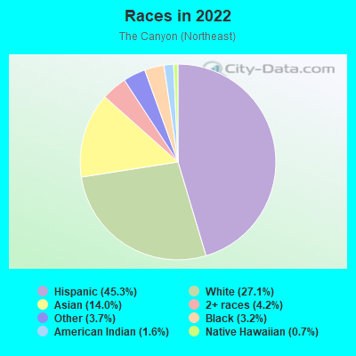
- 8,00345.3%Hispanic or Latino
- 4,79627.1%White
- 2,47614.0%Asian
- 7474.2%Two or more races
- 6513.7%Some other race
- 5703.2%Black
- 2911.6%American Indian
- 1310.7%Native Hawaiian and Other
Pacific Islander
Median household income in 2022:
| The Canyon (Northeast): | $110,517 |
| Anaheim: | $85,133 |
Distribution of median household income
![Distribution of median household income]()
- 434Less than $10,000
- 2,326$10,000 to $19,999
- 1,036$20,000 to $29,999
- 287$30,000 to $39,999
- 2,322$40,000 to $49,999
- 369$50,000 to $59,999
- 873$60,000 to $74,999
- 808$75,000 to $99,999
- 395$100,000 to $124,999
- 455$125,000 to $149,999
- 912$150,000 to $199,999
- 868$200,000 or more

Distribution of owner-occupied house/condo value
![Distribution of owner-occupied house/condo value]()
- 1,258Less than $50,000
- 3,712$50,000 to $99,999
- 357$100,000 to $149,999
- 2,500$150,000 to $199,999
- 1,058$200,000 to $249,999
- 88$250,000 to $299,999
- 455$300,000 to $399,999
- 940$400,000 to $499,999
- 795$500,000 to $749,999
- 4,119$750,000 to $999,999
- 1,820$1,000,000 or more

Distribution of rent paid by renters
![Distribution of rent paid by renters]()
- 136Less than $100
- 1,673$200 to $299
- 1,850$400 to $499
- 4,771$500 to $599
- 1,265$600 to $699
- 112$700 to $799
- 1,107$800 to $899
- 1,595$1,000 to $1,249
- 716$1,250 to $1,499
- 1,112$1,500 to $1,999
- 1,747$2,000 or more

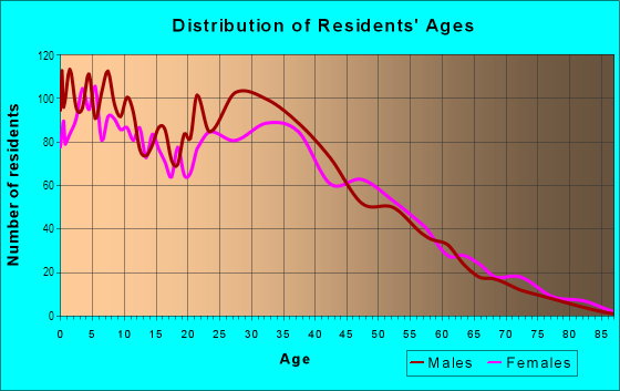
| Males: | 7,866 |
| Females: | 8,644 |
Males:
| This neighborhood: | 39.9 years |
| Whole city: | 35.7 years |
| This neighborhood: | 38.8 years |
| Whole city: | 36.4 years |
Average household size:
| The Canyon (Northeast): | 6.0 people |
| Anaheim: | 3.2 people |
Percentage of family households:
| The Canyon (Northeast): | 54.0% |
| Anaheim: | 51.4% |
| Here: | 44.3% |
| Anaheim: | 46.5% |
Percentage of married-couple families with children (among all households):
| The Canyon (Northeast): | 22.0% |
| Anaheim: | 19.1% |
Percentage of single-mother households (among all households):
| The Canyon (Northeast): | 9.9% |
| Anaheim: | 7.8% |
Percentage of never married males 15 years old and over:
Percentage of never married females 15 years old and over:
| The Canyon (Northeast): | 19.0% |
| Anaheim: | 21.3% |
Percentage of never married females 15 years old and over:
| The Canyon (Northeast): | 18.2% |
| city: | 20.3% |
Percentage of people that speak English not well or not at all:
| The Canyon (Northeast): | 10.0% |
| Anaheim: | 13.3% |
Percentage of people born in this state:
Percentage of people born in another U.S. state:
Percentage of native residents but born outside the U.S.:
Percentage of foreign born residents:
| Here: | 58.5% |
| Anaheim: | 53.8% |
Percentage of people born in another U.S. state:
| The Canyon (Northeast): | 12.3% |
| Anaheim: | 9.0% |
Percentage of native residents but born outside the U.S.:
| Here: | 1.4% |
| city: | 1.0% |
Percentage of foreign born residents:
| Here: | 28.2% |
| Anaheim: | 36.2% |
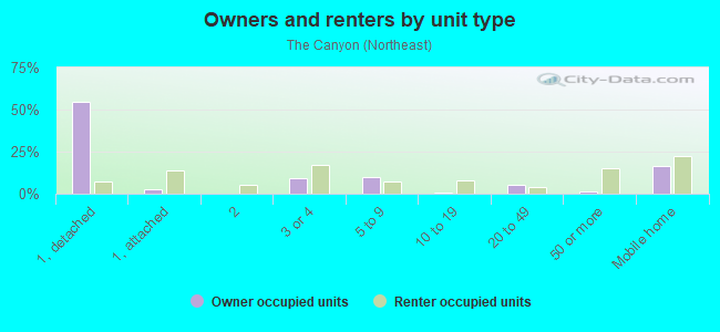
Owner-occupied
Renter-occupied


- Rooms in owner-occupied houses and condos in The Canyon <
> - 1,6431 room
- 4592 rooms
- 4243 rooms
- 9584 rooms
- 1,4105 rooms
- 9726 rooms
- 1,1807 rooms
- 1,7888 rooms
- 9339+ rooms
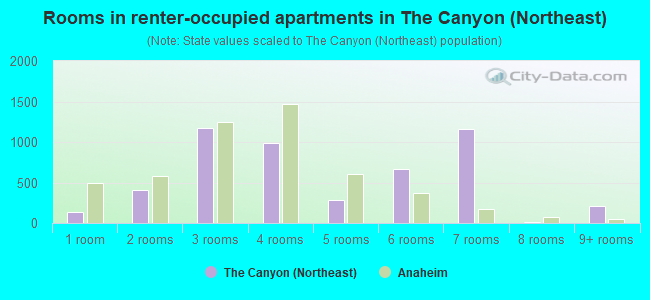
- Rooms in renter-occupied apartments in The Canyon <
> - 1401 room
- 4112 rooms
- 1,1793 rooms
- 9864 rooms
- 2785 rooms
- 6726 rooms
- 1,1587 rooms
- 148 rooms
- 2089+ rooms
Owner-occupied
Renter-occupied
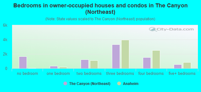
- Bedrooms in owner-occupied houses and condos in The Canyon <
> - 1,643no bedroom
- 3581 bedroom
- 1,2442 bedrooms
- 3,3343 bedrooms
- 1,5224 bedrooms
- 5515+ bedrooms
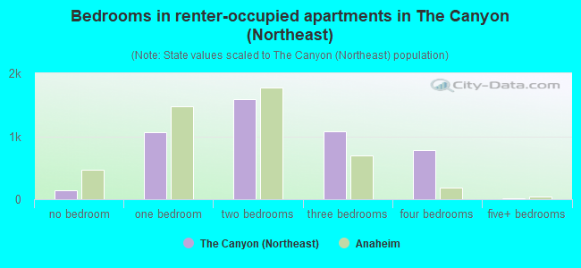
- Bedrooms in renter-occupied apartments in The Canyon <
> - 143no bedroom
- 1,0581 bedroom
- 1,5932 bedrooms
- 1,0723 bedrooms
- 7744 bedrooms
- 125+ bedrooms
Average number of cars or other vehicles available in houses/condos:
Average number of cars or other vehicles available in apartments:
| This neighborhood: | |
| Anaheim: |
Average number of cars or other vehicles available in apartments:
| Here: | |
| city: |
Percentage of units with a mortgage:
| The Canyon (Northeast): | 85.9% |
| Anaheim: | 66.9% |
Average estimated value of detached houses in 2022 (55.4% of all units):
| The Canyon (Northeast): | $568,225 |
| Anaheim: | $932,371 |

- Year house built in The Canyon <
> - 1692020 or later
- 3902010 to 2019
- 5602000 to 2009
- 3881990 to 1999
- 4961980 to 1989
- 2,1911970 to 1979
- 1,7901960 to 1969
- 6581950 to 1959
- 7871940 to 1949
- 5551939 or earlier
City-data.com crime index for city in 2020 (higher means more crime):
| City: | 244.1 |
| U.S. average: | 219.5 |
Travel time to work (commute)
![Travel time to work (commute)]()
- 214Less than 5 minutes
- 4985 to 9 minutes
- 1,47810 to 14 minutes
- 1,38215 to 19 minutes
- 1,10220 to 24 minutes
- 32525 to 29 minutes
- 1,12930 to 34 minutes
- 44435 to 39 minutes
- 24240 to 44 minutes
- 63045 to 59 minutes
- 42760 to 89 minutes
- 23590 or more minutes

Means of transportation to work
![Means of transportation to work]()
- 78.1%6,096Drove a car alone
- 10.9%851Carpooled
- 7.3%569Bus
- 14.6%1,138Subway or elevated rail
- 0.9%72Long-distance train or commuter rail
- 2.4%184Taxi
- 0.8%60Motorcycle
- 2.5%193Bicycle
- 0.8%66Walked
- 5.6%435Other means
- 7.7%601Worked at home

Time leaving home to go to work
![Time leaving home to go to work]()
- 75612:00 a.m. to 4:59 a.m.
- 4355:00 a.m. to 5:29 a.m.
- 4515:30 a.m. to 5:59 a.m.
- 7116:00 a.m. to 6:29 a.m.
- 5206:30 a.m. to 6:59 a.m.
- 1,0217:00 a.m. to 7:29 a.m.
- 7287:30 a.m. to 7:59 a.m.
- 9918:00 a.m. to 8:29 a.m.
- 3398:30 a.m. to 8:59 a.m.
- 4199:00 a.m. to 9:59 a.m.
- 38610:00 a.m. to 10:59 a.m.
- 39011:00 a.m. to 11:59 a.m.
- 69112:00 p.m. to 3:59 p.m.
- 3224:00 p.m. to 11:59 p.m.

Occupations of males:
- Percentage of males in management occupations (except farmers):
Here: 8.3% city: 9.7%
- Percentage of males in business and financial operations occupations:
Here: 5.4% city: 4.6%
- Percentage of males in computer and mathematical occupations:
Here: 5.2% city: 3.7%
- Percentage of males in architecture and engineering occupations:
Here: 3.5% city: 3.0%
- Percentage of males in education, training, and library occupations:
Here: 3.2% city: 2.3%
- Percentage of males in arts, design, entertainment, sports, and media occupations:
Here: 2.3% city: 2.1%
- Percentage of males in healthcare practitioners and technical occupations:
Here: 2.1% city: 3.3%
- Percentage of males in service occupations:
Here: 16.7% city: 15.9%
- Percentage of males in sales and office occupations:
Here: 16.8% city: 16.6%
- Percentage of males in construction, extraction, and maintenance occupations:
Here: 10.8% city: 10.5%
- Percentage of males in production occupations:
Here: 8.4% city: 9.0%
- Percentage of males in transportation occupations:
Here: 4.1% city: 6.7%
- Percentage of males in material moving occupations:
Here: 7.8% city: 5.4%
Occupations of females:
- Percentage of females in management occupations (except farmers):
Here: 6.0% city: 7.8%
- Percentage of females in business and financial operations occupations:
Here: 9.5% city: 6.2%
- Percentage of females in architecture and engineering occupations:
Here: 1.1% city: 0.8%
- Percentage of females in community and social services occupations:
Here: 2.1% city: 2.3%
- Percentage of females in education, training, and library occupations:
Here: 10.4% city: 6.5%
- Percentage of females in arts, design, entertainment, sports, and media occupations:
Here: 2.3% city: 2.1%
- Percentage of females in healthcare practitioners and technical occupations:
Here: 14.8% city: 7.6%
- Percentage of females in service occupations:
Here: 17.5% city: 24.2%
- Percentage of females in sales and office occupations:
Here: 26.4% city: 30.3%
- Percentage of females in production occupations:
Here: 3.2% city: 4.9%
- Percentage of females in transportation occupations:
Here: 1.3% city: 0.9%
- Percentage of females in material moving occupations:
Here: 2.7% city: 2.3%
Percentage of people 16-64 in Armed Forces:
| The Canyon (Northeast): | 0.0% |
| Anaheim: | 0.1% |
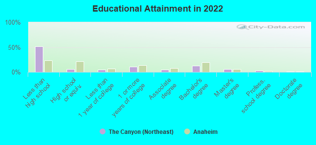
Education in this neighborhood (subdivision or community):
- Percentage of people 3 years and older in K-12 schools:
The Canyon (Northeast): 24.9% Anaheim: 16.3%
- Percentage of people 3 years and older in undergraduate colleges:
The Canyon (Northeast): 7.8% Anaheim: 8.5%
- Percentage of people 3 years and older in grad. or professional schools:
The Canyon (Northeast): 7.0% Anaheim: 1.6%
- Percentage of students K-12 enrolled in private schools:
The Canyon (Northeast): 69.2% Anaheim: 7.1%
Percentage of population below poverty level:
| The Canyon (Northeast): | 17.6% |
| Anaheim: | 14.1% |
Percentage of married-couple families with both working:
| The Canyon (Northeast): | 109.7% |
| Anaheim: | 64.5% |
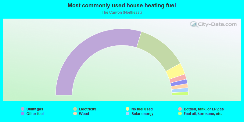
- 59.5%Utility gas
- 24.7%Electricity
- 5.6%No fuel used
- 2.5%Bottled, tank, or LP gas
- 2.2%Other fuel
- 2.0%Wood
- 2.0%Solar energy
- 1.6%Fuel oil, kerosene, etc.
Limited-access highways (interstate or state) in this neighborhood:
State Hwy 91 (Riverside Fwy)
Length: 2.95 miles
Directions: E-W, SE-NW, SW-NE
Directions: E-W, SE-NW, SW-NE
State Hwy 57 (Orange Fwy)
Length: 0.39 miles
Direction: N-S
Direction: N-S
Highways in this neighborhood:
Richard M Nixon Hwy (State Hwy 90, S Imperial Hwy)
Length: 0.52 miles
Direction: N-S
Direction: N-S
Roads and streets:
E la Palma Ave (la Palma Ave)
Length: 5.53 miles
Directions: E-W, SW-NE
Address range: 2800 to 5699
Directions: E-W, SW-NE
Address range: 2800 to 5699
E Miraloma Ave
Length: 3.49 miles
Directions: E-W, SW-NE
Address range: 1996 to 4499
Directions: E-W, SW-NE
Address range: 1996 to 4499
Orangethorpe Ave (E Orangethorpe Ave)
Length: 2.94 miles
Direction: E-W
Address range: 801 to 5642
Direction: E-W
Address range: 801 to 5642
91
Length: 1.72 miles
Directions: E-W, SE-NW
Directions: E-W, SE-NW
E Riverdale Ave
Length: 1.51 miles
Directions: E-W, SW-NE
Address range: 3852 to 4699
Directions: E-W, SW-NE
Address range: 3852 to 4699
E Coronado St
Length: 1.18 miles
Direction: E-W
Address range: 2700 to 3199
Direction: E-W
Address range: 2700 to 3199
E Hunter Ave
Length: 1.16 miles
Directions: E-W, SE-NW
Address range: 4700 to 5399
Directions: E-W, SE-NW
Address range: 4700 to 5399
N Kraemer Blvd
Length: 1.13 miles
Directions: N-S, SE-NW
Address range: 1000 to 1599
Directions: N-S, SE-NW
Address range: 1000 to 1599
N Grove St
Length: 1.04 miles
Directions: E-W, N-S, SE-NW, SW-NE
Address range: 900 to 1299
Directions: E-W, N-S, SE-NW, SW-NE
Address range: 900 to 1299
N Miller St
Length: 1.01 miles
Direction: N-S
Address range: 1100 to 1699
Direction: N-S
Address range: 1100 to 1699
N Red Gum St
Length: 0.94 miles
Direction: N-S
Address range: 1100 to 1499
Direction: N-S
Address range: 1100 to 1499
Tustin Ave
Length: 0.87 miles
Directions: N-S, SE-NW
Address range: 1100 to 1499
Directions: N-S, SE-NW
Address range: 1100 to 1499
E la Jolla St
Length: 0.87 miles
Direction: E-W
Address range: 2900 to 3199
Direction: E-W
Address range: 2900 to 3199
S Lakeview Ave
Length: 0.87 miles
Directions: N-S, SE-NW
Directions: N-S, SE-NW
E Crowther Ave
Length: 0.86 miles
Direction: E-W
Address range: 501 to 3398
Direction: E-W
Address range: 501 to 3398
N Tustin St
Length: 0.83 miles
Directions: N-S, SE-NW
Address range: 300 to 568
Directions: N-S, SE-NW
Address range: 300 to 568
E Addington Dr
Length: 0.83 miles
Directions: E-W, SE-NW, SW-NE
Address range: 4100 to 4499
Directions: E-W, SE-NW, SW-NE
Address range: 4100 to 4499
N Blue Gum St
Length: 0.70 miles
Directions: N-S, SE-NW
Address range: 1000 to 1399
Directions: N-S, SE-NW
Address range: 1000 to 1399
E Alderdale Ave
Length: 0.66 miles
Directions: E-W, SE-NW, SW-NE
Address range: 4100 to 4499
Directions: E-W, SE-NW, SW-NE
Address range: 4100 to 4499
E White Star Ave
Length: 0.64 miles
Directions: E-W, SE-NW, SW-NE
Address range: 2760 to 7073
Directions: E-W, SE-NW, SW-NE
Address range: 2760 to 7073
E Bainbridge Ave
Length: 0.56 miles
Directions: E-W, SW-NE
Address range: 4100 to 4499
Directions: E-W, SW-NE
Address range: 4100 to 4499
E Radcliffe Ave
Length: 0.52 miles
Direction: E-W
Address range: 3100 to 3399
Direction: E-W
Address range: 3100 to 3399
Richfield Rd
Length: 0.48 miles
Direction: N-S
Address range: 1000 to 1299
Direction: N-S
Address range: 1000 to 1299
Jefferson St (N Jefferson St)
Length: 0.47 miles
Directions: E-W, N-S, SW-NE
Address range: 1150 to 6599
Directions: E-W, N-S, SW-NE
Address range: 1150 to 6599
N Kraemer Pl
Length: 0.47 miles
Direction: N-S
Address range: 1000 to 1199
Direction: N-S
Address range: 1000 to 1199
N Armando St
Length: 0.45 miles
Directions: E-W, N-S, SE-NW, SW-NE
Address range: 1000 to 1199
Directions: E-W, N-S, SE-NW, SW-NE
Address range: 1000 to 1199
E la Cresta Ave
Length: 0.44 miles
Direction: E-W
Address range: 2800 to 2999
Direction: E-W
Address range: 2800 to 2999
Fee Ana St
Length: 0.41 miles
Direction: N-S
Direction: N-S
Coronado St
Length: 0.41 miles
Direction: E-W
Address range: 3800 to 4199
Direction: E-W
Address range: 3800 to 4199
Valley Forge Dr
Length: 0.39 miles
Directions: E-W, N-S, SE-NW, SW-NE
Address range: 150 to 424
Directions: E-W, N-S, SE-NW, SW-NE
Address range: 150 to 424
57
Length: 0.39 miles
Directions: N-S, SE-NW
Directions: N-S, SE-NW
Kellogg Dr
Length: 0.39 miles
Directions: N-S, SW-NE
Address range: 1200 to 1699
Directions: N-S, SW-NE
Address range: 1200 to 1699
N Deerfield St
Length: 0.35 miles
Directions: N-S, SE-NW
Address range: 100 to 499
Directions: N-S, SE-NW
Address range: 100 to 499
E Landon Dr
Length: 0.35 miles
Direction: E-W
Address range: 4900 to 5099
Direction: E-W
Address range: 4900 to 5099
N Bluerock St
Length: 0.35 miles
Direction: SE-NW
Address range: 100 to 499
Direction: SE-NW
Address range: 100 to 499
E Miraloma Way
Length: 0.34 miles
Directions: E-W, SW-NE
Address range: 2500 to 2699
Directions: E-W, SW-NE
Address range: 2500 to 2699
E Maychelle Dr
Length: 0.34 miles
Direction: E-W
Address range: 4700 to 4899
Direction: E-W
Address range: 4700 to 4899
N Pacificenter Dr
Length: 0.34 miles
Directions: E-W, N-S, SW-NE
Address range: 1000 to 1099
Directions: E-W, N-S, SW-NE
Address range: 1000 to 1099
N Redrock St
Length: 0.33 miles
Direction: SE-NW
Address range: 115 to 429
Direction: SE-NW
Address range: 115 to 429
E McKinnon Dr
Length: 0.33 miles
Directions: E-W, SW-NE
Address range: 4700 to 4899
Directions: E-W, SW-NE
Address range: 4700 to 4899
Hancock St
Length: 0.33 miles
Direction: N-S
Address range: 1200 to 1499
Direction: N-S
Address range: 1200 to 1499
Ocean Cir
Length: 0.32 miles
Directions: E-W, N-S, SW-NE
Directions: E-W, N-S, SW-NE
N Manassero St
Length: 0.31 miles
Direction: N-S
Address range: 1200 to 1499
Direction: N-S
Address range: 1200 to 1499
E Blue Star St
Length: 0.31 miles
Directions: E-W, SW-NE
Address range: 2800 to 2999
Directions: E-W, SW-NE
Address range: 2800 to 2999
E Frontera St
Length: 0.29 miles
Direction: E-W
Address range: 3200 to 3399
Direction: E-W
Address range: 3200 to 3399
E Summer Creek Ln
Length: 0.29 miles
Directions: E-W, N-S, SE-NW, SW-NE
Directions: E-W, N-S, SE-NW, SW-NE
E Terrace St
Length: 0.28 miles
Directions: E-W, SE-NW
Address range: 2400 to 2599
Directions: E-W, SE-NW
Address range: 2400 to 2599
N Sweetwater St
Length: 0.27 miles
Directions: N-S, SE-NW
Address range: 100 to 399
Directions: N-S, SE-NW
Address range: 100 to 399
N Kodiak St
Length: 0.27 miles
Directions: N-S, SE-NW
Address range: 156 to 499
Directions: N-S, SE-NW
Address range: 156 to 499
N Sunshine Way
Length: 0.27 miles
Directions: N-S, SE-NW, SW-NE
Address range: 1200 to 1399
Directions: N-S, SE-NW, SW-NE
Address range: 1200 to 1399
N la Loma Cir
Length: 0.25 miles
Directions: E-W, N-S, SE-NW, SW-NE
Address range: 1200 to 1299
Directions: E-W, N-S, SE-NW, SW-NE
Address range: 1200 to 1299
Jefferson Frontage Rd
Length: 0.24 miles
Directions: E-W, N-S
Directions: E-W, N-S
E Gretta Ln
Length: 0.24 miles
Direction: E-W
Address range: 2700 to 2899
Direction: E-W
Address range: 2700 to 2899
E Park Ln
Length: 0.24 miles
Direction: E-W
Address range: 2400 to 2609
Direction: E-W
Address range: 2400 to 2609
S Jefferson St
Length: 0.24 miles
Direction: N-S
Address range: 400 to 6399
Direction: N-S
Address range: 400 to 6399
E Gayann Dr
Length: 0.23 miles
Directions: E-W, N-S, SW-NE
Address range: 4800 to 4999
Directions: E-W, N-S, SW-NE
Address range: 4800 to 4999
Orchard Way
Length: 0.22 miles
Direction: E-W
Direction: E-W
Harmony Cir
Length: 0.22 miles
Directions: E-W, N-S, SE-NW, SW-NE
Address range: 1500 to 1599
Directions: E-W, N-S, SE-NW, SW-NE
Address range: 1500 to 1599
Brasher St
Length: 0.22 miles
Directions: N-S, SE-NW
Address range: 1300 to 1499
Directions: N-S, SE-NW
Address range: 1300 to 1499
N Pageant St
Length: 0.21 miles
Directions: N-S, SE-NW
Address range: 200 to 299
Directions: N-S, SE-NW
Address range: 200 to 299
E Wasatch Dr
Length: 0.21 miles
Directions: E-W, SW-NE
Address range: 4826 to 4999
Directions: E-W, SW-NE
Address range: 4826 to 4999
N Starfire St
Length: 0.21 miles
Directions: E-W, SE-NW, SW-NE
Address range: 200 to 399
Directions: E-W, SE-NW, SW-NE
Address range: 200 to 399
Eagle Dr
Length: 0.21 miles
Direction: E-W
Address range: 3800 to 3899
Direction: E-W
Address range: 3800 to 3899
Merrimac Dr
Length: 0.21 miles
Directions: E-W, N-S, SE-NW
Address range: 100 to 299
Directions: E-W, N-S, SE-NW
Address range: 100 to 299
Terrace St
Length: 0.21 miles
Direction: E-W
Direction: E-W
N Barry Knoll St
Length: 0.20 miles
Directions: SE-NW, SW-NE
Address range: 200 to 429
Directions: SE-NW, SW-NE
Address range: 200 to 429
N Torrens St
Length: 0.20 miles
Direction: SE-NW
Address range: 201 to 499
Direction: SE-NW
Address range: 201 to 499
Sagamore St
Length: 0.19 miles
Directions: N-S, SE-NW
Address range: 200 to 299
Directions: N-S, SE-NW
Address range: 200 to 299
E Regal Park Dr
Length: 0.18 miles
Directions: E-W, N-S, SE-NW
Address range: 2700 to 2799
Directions: E-W, N-S, SE-NW
Address range: 2700 to 2799
E Lancaster Ave
Length: 0.17 miles
Direction: E-W
Address range: 3100 to 3199
Direction: E-W
Address range: 3100 to 3199
N Pheasant St
Length: 0.17 miles
Direction: N-S
Address range: 1700 to 1799
Direction: N-S
Address range: 1700 to 1799
E la Mesa St
Length: 0.16 miles
Direction: E-W
Address range: 2800 to 3099
Direction: E-W
Address range: 2800 to 3099
N Van Buren St
Length: 0.16 miles
Direction: N-S
Address range: 1200 to 1299
Direction: N-S
Address range: 1200 to 1299
Fountain Way
Length: 0.16 miles
Direction: N-S
Direction: N-S
E Elkstone Ave
Length: 0.16 miles
Direction: E-W
Address range: 4300 to 4399
Direction: E-W
Address range: 4300 to 4399
N Landfair St
Length: 0.16 miles
Direction: N-S
Address range: 1700 to 1799
Direction: N-S
Address range: 1700 to 1799
E Leaverton Ct
Length: 0.16 miles
Direction: E-W
Address range: 4000 to 40098
Direction: E-W
Address range: 4000 to 40098
N Rutherford St
Length: 0.15 miles
Directions: E-W, N-S, SE-NW
Address range: 1700 to 1799
Directions: E-W, N-S, SE-NW
Address range: 1700 to 1799
E Bluewater Cir
Length: 0.15 miles
Directions: E-W, SW-NE
Address range: 4348 to 4425
Directions: E-W, SW-NE
Address range: 4348 to 4425
Hawk Cir
Length: 0.14 miles
Directions: E-W, N-S, SE-NW
Address range: 1100 to 1199
Directions: E-W, N-S, SE-NW
Address range: 1100 to 1199
Finch St
Length: 0.14 miles
Directions: N-S, SE-NW
Address range: 200 to 399
Directions: N-S, SE-NW
Address range: 200 to 399
E Carpenter Ave
Length: 0.14 miles
Directions: E-W, N-S
Address range: 3200 to 3299
Directions: E-W, N-S
Address range: 3200 to 3299
N Kent St
Length: 0.14 miles
Direction: N-S
Address range: 1700 to 1799
Direction: N-S
Address range: 1700 to 1799
N Meadowlark Ln
Length: 0.14 miles
Direction: N-S
Address range: 1700 to 1799
Direction: N-S
Address range: 1700 to 1799
N Shasta St
Length: 0.13 miles
Directions: E-W, N-S, SE-NW
Address range: 400 to 449
Directions: E-W, N-S, SE-NW
Address range: 400 to 449
55
Length: 0.13 miles
Directions: E-W, SW-NE
Directions: E-W, SW-NE
N Shepard St
Length: 0.13 miles
Direction: N-S
Address range: 1000 to 1099
Direction: N-S
Address range: 1000 to 1099
N Manti Dr
Length: 0.13 miles
Directions: N-S, SE-NW
Address range: 400 to 499
Directions: N-S, SE-NW
Address range: 400 to 499
N Oxford St
Length: 0.12 miles
Direction: N-S
Address range: 1700 to 1799
Direction: N-S
Address range: 1700 to 1799
E Fauna Ave
Length: 0.12 miles
Directions: E-W, SW-NE
Address range: 4100 to 4199
Directions: E-W, SW-NE
Address range: 4100 to 4199
Alderdale Way
Length: 0.12 miles
Direction: E-W
Direction: E-W
N Starling Way
Length: 0.12 miles
Directions: N-S, SE-NW, SW-NE
Address range: 200 to 399
Directions: N-S, SE-NW, SW-NE
Address range: 200 to 399
E Sandpiper Ave
Length: 0.12 miles
Direction: E-W
Address range: 3000 to 3099
Direction: E-W
Address range: 3000 to 3099
N Citrus View Dr
Length: 0.12 miles
Directions: N-S, SE-NW
Address range: 400 to 499
Directions: N-S, SE-NW
Address range: 400 to 499
N Lakedale Dr
Length: 0.11 miles
Directions: N-S, SE-NW, SW-NE
Address range: 200 to 399
Directions: N-S, SE-NW, SW-NE
Address range: 200 to 399
N Sheffield St
Length: 0.11 miles
Direction: N-S
Address range: 1700 to 1799
Direction: N-S
Address range: 1700 to 1799
E Via Martens
Length: 0.11 miles
Direction: E-W
Address range: 2800 to 2899
Direction: E-W
Address range: 2800 to 2899
Bryson St
Length: 0.10 miles
Direction: E-W
Address range: 4700 to 4799
Direction: E-W
Address range: 4700 to 4799
Wesley Dr
Length: 0.10 miles
Direction: E-W
Address range: 4700 to 4799
Direction: E-W
Address range: 4700 to 4799
N Cosby Way
Length: 0.10 miles
Direction: N-S
Address range: 1100 to 1199
Direction: N-S
Address range: 1100 to 1199
Holtwood Ave
Length: 0.10 miles
Direction: E-W
Address range: 4338 to 4365
Direction: E-W
Address range: 4338 to 4365
N Hundley St
Length: 0.10 miles
Direction: N-S
Address range: 1300 to 1399
Direction: N-S
Address range: 1300 to 1399
E Ricker Way
Length: 0.10 miles
Direction: E-W
Address range: 2900 to 2999
Direction: E-W
Address range: 2900 to 2999
N Barsten Way
Length: 0.10 miles
Direction: N-S
Address range: 1200 to 1299
Direction: N-S
Address range: 1200 to 1299
N Kennebec Dr
Length: 0.10 miles
Direction: N-S
Address range: 200 to 299
Direction: N-S
Address range: 200 to 299
N Lawrence Ave
Length: 0.10 miles
Directions: N-S, SE-NW
Address range: 1300 to 1399
Directions: N-S, SE-NW
Address range: 1300 to 1399
N Fashion Ln
Length: 0.09 miles
Direction: N-S
Address range: 1300 to 1399
Direction: N-S
Address range: 1300 to 1399
N Lance Ln
Length: 0.09 miles
Direction: N-S
Address range: 1200 to 1299
Direction: N-S
Address range: 1200 to 1299
N Van Horne Way
Length: 0.09 miles
Direction: N-S
Address range: 1100 to 1199
Direction: N-S
Address range: 1100 to 1199
Grove St
Length: 0.09 miles
Direction: E-W
Direction: E-W
N McCan St
Length: 0.09 miles
Direction: N-S
Address range: 1300 to 1399
Direction: N-S
Address range: 1300 to 1399
N Glassell St
Length: 0.09 miles
Direction: SE-NW
Address range: 7900 to 8099
Direction: SE-NW
Address range: 7900 to 8099
E Beauty Dr
Length: 0.09 miles
Direction: SW-NE
Address range: 4500 to 4699
Direction: SW-NE
Address range: 4500 to 4699
Bunker Hill Pl
Length: 0.08 miles
Directions: SE-NW, SW-NE
Address range: 4000 to 4099
Directions: SE-NW, SW-NE
Address range: 4000 to 4099
Rogue Dr
Length: 0.08 miles
Direction: E-W
Address range: 3900 to 3999
Direction: E-W
Address range: 3900 to 3999
N Simon Cir
Length: 0.08 miles
Direction: N-S
Address range: 1200 to 1299
Direction: N-S
Address range: 1200 to 1299
S Van Buren St
Length: 0.08 miles
Direction: N-S
Address range: 1000 to 1399
Direction: N-S
Address range: 1000 to 1399
Iron Pike Cir
Length: 0.08 miles
Directions: E-W, N-S, SE-NW
Address range: 300 to 399
Directions: E-W, N-S, SE-NW
Address range: 300 to 399
Longbranch Dr
Length: 0.08 miles
Directions: E-W, SW-NE
Address range: 4000 to 4099
Directions: E-W, SW-NE
Address range: 4000 to 4099
Cambridge Cir
Length: 0.08 miles
Direction: N-S
Direction: N-S
N Bedford Cir
Length: 0.08 miles
Direction: N-S
Address range: 1700 to 1799
Direction: N-S
Address range: 1700 to 1799
Van Buren St
Length: 0.08 miles
Directions: N-S, SE-NW
Directions: N-S, SE-NW
N Dynamics St
Length: 0.07 miles
Direction: N-S
Address range: 1100 to 1199
Direction: N-S
Address range: 1100 to 1199
E Ceena Ct
Length: 0.07 miles
Direction: E-W
Address range: 3000 to 3099
Direction: E-W
Address range: 3000 to 3099
N Roni Ln
Length: 0.07 miles
Direction: N-S
Address range: 400 to 499
Direction: N-S
Address range: 400 to 499
E Santa Ana Canyon Rd
Length: 0.07 miles
Directions: N-S, SW-NE
Directions: N-S, SW-NE
N Park Ln
Length: 0.07 miles
Direction: E-W
Address range: 2610 to 2681
Direction: E-W
Address range: 2610 to 2681
E Addington Cir
Length: 0.07 miles
Directions: N-S, SE-NW, SW-NE
Address range: 4101 to 4199
Directions: N-S, SE-NW, SW-NE
Address range: 4101 to 4199
Lani Ave
Length: 0.07 miles
Direction: E-W
Direction: E-W
Osprey Cir
Length: 0.06 miles
Directions: E-W, N-S
Address range: 1150 to 1199
Directions: E-W, N-S
Address range: 1150 to 1199
E Melville Way
Length: 0.06 miles
Direction: E-W
Address range: 3700 to 3799
Direction: E-W
Address range: 3700 to 3799
N Fountain Way
Length: 0.06 miles
Direction: N-S
Address range: 1100 to 1199
Direction: N-S
Address range: 1100 to 1199
Enterprise Dr
Length: 0.06 miles
Direction: SW-NE
Address range: 3500 to 3599
Direction: SW-NE
Address range: 3500 to 3599
E Bainbridge Cir
Length: 0.06 miles
Direction: E-W
Address range: 4400 to 4499
Direction: E-W
Address range: 4400 to 4499
N Roxanne St
Length: 0.06 miles
Directions: N-S, SE-NW
Address range: 400 to 499
Directions: N-S, SE-NW
Address range: 400 to 499
N Bates Cir
Length: 0.06 miles
Direction: N-S
Address range: 1700 to 1799
Direction: N-S
Address range: 1700 to 1799
Flintlock Way
Length: 0.06 miles
Direction: E-W
Address range: 4000 to 4099
Direction: E-W
Address range: 4000 to 4099
Park Ln
Length: 0.05 miles
Direction: E-W
Direction: E-W
E McKay Cir
Length: 0.05 miles
Direction: E-W
Address range: 4800 to 4899
Direction: E-W
Address range: 4800 to 4899
N Thames Cir
Length: 0.04 miles
Direction: N-S
Address range: 1700 to 1799
Direction: N-S
Address range: 1700 to 1799
Etchandy Ln
Length: 0.04 miles
Direction: N-S
Direction: N-S
Park Rose Cir (E Park Rose Cir)
Length: 0.04 miles
Direction: E-W
Address range: 4700 to 4799
Direction: E-W
Address range: 4700 to 4799
Six St
Length: 0.04 miles
Direction: N-S
Direction: N-S
E Astoria Cir
Length: 0.04 miles
Direction: E-W
Address range: 4700 to 4799
Direction: E-W
Address range: 4700 to 4799
Crockett Dr
Length: 0.04 miles
Direction: SW-NE
Address range: 4000 to 4049
Direction: SW-NE
Address range: 4000 to 4049
N Las Brisas St
Length: 0.04 miles
Directions: N-S, SE-NW, SW-NE
Address range: 1200 to 1299
Directions: N-S, SE-NW, SW-NE
Address range: 1200 to 1299
E Lani Ave
Length: 0.04 miles
Direction: E-W
Address range: 4400 to 4499
Direction: E-W
Address range: 4400 to 4499
E Claytor Cir
Length: 0.04 miles
Directions: E-W, SW-NE
Address range: 4300 to 4399
Directions: E-W, SW-NE
Address range: 4300 to 4399
Via Breve
Length: 0.04 miles
Direction: N-S
Direction: N-S
N Bubach St
Length: 0.04 miles
Direction: N-S
Direction: N-S
Wendy Cicle
Length: 0.04 miles
Direction: SW-NE
Direction: SW-NE
Thames St
Length: 0.04 miles
Direction: N-S
Address range: 1700 to 1723
Direction: N-S
Address range: 1700 to 1723
N Powder Horn Dr
Length: 0.04 miles
Direction: N-S
Address range: 400 to 499
Direction: N-S
Address range: 400 to 499
3rd St
Length: 0.04 miles
Direction: N-S
Direction: N-S
N Conestoga Way
Length: 0.04 miles
Direction: N-S
Address range: 400 to 424
Direction: N-S
Address range: 400 to 424
E Horseshoe Ln
Length: 0.03 miles
Direction: SE-NW
Address range: 4000 to 4099
Direction: SE-NW
Address range: 4000 to 4099
Wallgreen St
Length: 0.03 miles
Direction: N-S
Address range: 1204 to 1599
Direction: N-S
Address range: 1204 to 1599
N Leaf Cir (Leaf Cir)
Length: 0.03 miles
Directions: N-S, SE-NW
Address range: 400 to 499
Directions: N-S, SE-NW
Address range: 400 to 499
E Cul de Sac Ave
Length: 0.03 miles
Direction: E-W
Address range: 4600 to 4699
Direction: E-W
Address range: 4600 to 4699
N Stratford Cir
Length: 0.02 miles
Direction: N-S
Address range: 1700 to 1799
Direction: N-S
Address range: 1700 to 1799
Railroad features:
Burlington Northern Santa Fe Rlwy
Length: 3.87 miles
Directions: E-W, N-S, SW-NE
Directions: E-W, N-S, SW-NE
Other features:
Carbon Creek Storm Chnnl
Length: 1.08 miles
Directions: N-S, SW-NE
Directions: N-S, SW-NE
Other features:
Carbon Canyon Crk
Length: 0.01 miles
Direction: N-S
Direction: N-S