Third Ward neighborhood in Houston, Texas (TX), 77004 detailed profile
Settings
X


Business Search - 14 Million verified businesses
Area: 2.953 square miles
Population: 17,784
Population density:
| Third Ward: | 6,022 people per square mile |
| Houston: | 3,977 people per square mile |

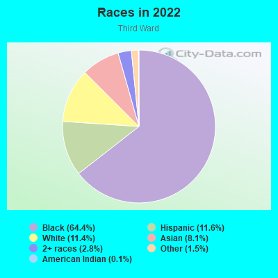
- 12,38664.4%Black
- 2,23111.6%Hispanic or Latino
- 2,19411.4%White
- 1,5598.1%Asian
- 5322.8%Two or more races
- 2961.5%Some other race
- 200.1%American Indian
Distribution of median household income
![Distribution of median household income]()
- 1,195Less than $10,000
- 1,324$10,000 to $19,999
- 744$20,000 to $29,999
- 773$30,000 to $39,999
- 622$40,000 to $49,999
- 667$50,000 to $59,999
- 371$60,000 to $74,999
- 706$75,000 to $99,999
- 843$100,000 to $124,999
- 443$125,000 to $149,999
- 569$150,000 to $199,999
- 885$200,000 or more

Distribution of owner-occupied house/condo value
![Distribution of owner-occupied house/condo value]()
- 506Less than $50,000
- 854$50,000 to $99,999
- 643$100,000 to $149,999
- 567$150,000 to $199,999
- 413$200,000 to $249,999
- 238$250,000 to $299,999
- 936$300,000 to $399,999
- 1,095$400,000 to $499,999
- 369$500,000 to $749,999
- 35$750,000 to $999,999
- 80$1,000,000 or more

Distribution of rent paid by renters
![Distribution of rent paid by renters]()
- 1,407Less than $100
- 980$100 to $199
- 1,086$200 to $299
- 876$300 to $399
- 629$400 to $499
- 1,151$500 to $599
- 899$600 to $699
- 1,235$700 to $799
- 529$800 to $899
- 619$900 to $999
- 945$1,000 to $1,249
- 416$1,250 to $1,499
- 293$1,500 to $1,999
- 1,041$2,000 or more

| Males: | 7,893 |
| Females: | 9,890 |
Males:
| This neighborhood: | 32.0 years |
| Whole city: | 34.4 years |
| This neighborhood: | 34.4 years |
| Whole city: | 34.7 years |
Average household size:
| Third Ward: | 2.3 people |
| Houston: | 2.4 people |
Percentage of family households:
| Third Ward: | 37.3% |
| Houston: | 43.0% |
| Here: | 17.9% |
| Houston: | 34.7% |
Percentage of married-couple families with children (among all households):
| Third Ward: | 11.2% |
| Houston: | 23.3% |
Percentage of single-mother households (among all households):
| Third Ward: | 31.0% |
| Houston: | 13.9% |
Percentage of never married males 15 years old and over:
Percentage of never married females 15 years old and over:
| Third Ward: | 27.8% |
| Houston: | 22.9% |
Percentage of never married females 15 years old and over:
| Third Ward: | 32.8% |
| city: | 21.2% |
Percentage of people that speak English not well or not at all:
| Third Ward: | 1.0% |
| Houston: | 15.9% |
Percentage of people born in this state:
Percentage of people born in another U.S. state:
Percentage of native residents but born outside the U.S.:
Percentage of foreign born residents:
| Here: | 62.9% |
| Houston: | 51.1% |
Percentage of people born in another U.S. state:
| Third Ward: | 26.0% |
| Houston: | 17.7% |
Percentage of native residents but born outside the U.S.:
| Here: | 1.4% |
| city: | 1.8% |
Percentage of foreign born residents:
| Here: | 10.2% |
| Houston: | 29.4% |
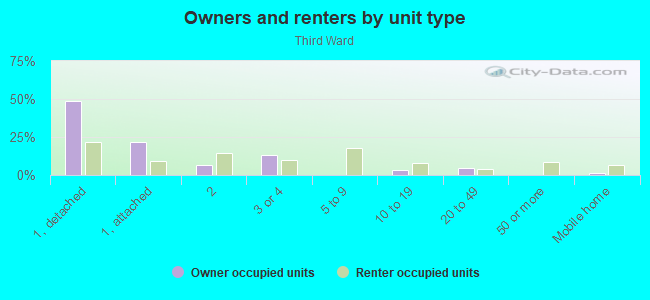
Owner-occupied
Renter-occupied

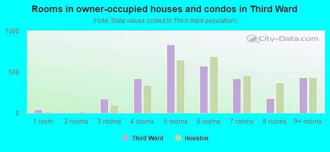
- Rooms in owner-occupied houses and condos in Third Ward
- 461 room
- 02 rooms
- 1733 rooms
- 4224 rooms
- 8315 rooms
- 5716 rooms
- 4227 rooms
- 1798 rooms
- 4309+ rooms
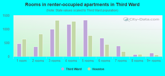
- Rooms in renter-occupied apartments in Third Ward
- 4691 room
- 3642 rooms
- 1,0033 rooms
- 1,1794 rooms
- 1,3375 rooms
- 6756 rooms
- 3907 rooms
- 738 rooms
- 1289+ rooms
Owner-occupied
Renter-occupied
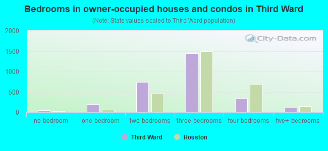
- Bedrooms in owner-occupied houses and condos in Third Ward
- 46no bedroom
- 1961 bedroom
- 7402 bedrooms
- 1,4423 bedrooms
- 3444 bedrooms
- 1095+ bedrooms
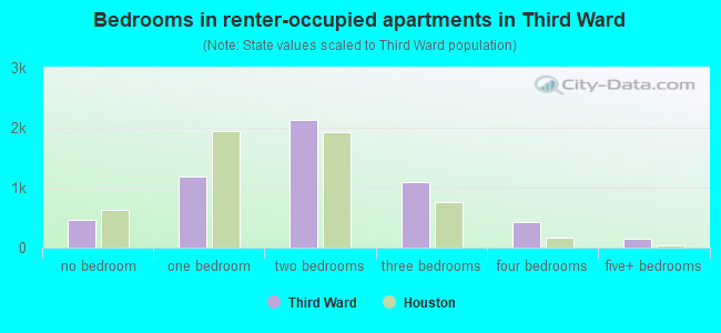
- Bedrooms in renter-occupied apartments in Third Ward
- 469no bedroom
- 1,1801 bedroom
- 2,1322 bedrooms
- 1,0903 bedrooms
- 4274 bedrooms
- 1425+ bedrooms
Average number of cars or other vehicles available in houses/condos:
Average number of cars or other vehicles available in apartments:
| This neighborhood: | 1.9 |
| Houston: | 2.0 |
Average number of cars or other vehicles available in apartments:
| Here: | 0.8 |
| city: | 1.3 |
Percentage of units with a mortgage:
| Third Ward: | 69.0% |
| Houston: | 50.8% |
Average estimated value of detached houses in 2022 (52.1% of all units):
| Third Ward: | $280,316 |
| Houston: | $368,067 |
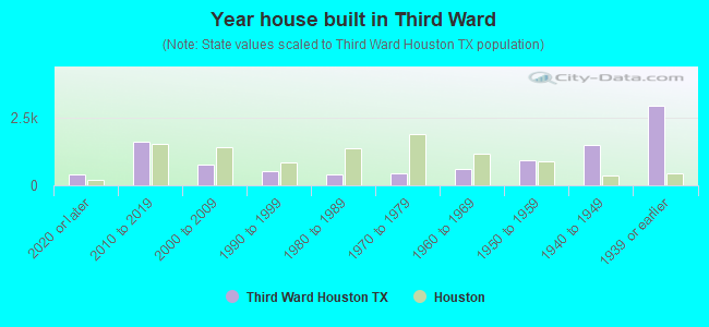
- Year house built in Third Ward
- 4172020 or later
- 1,6032010 to 2019
- 7512000 to 2009
- 5161990 to 1999
- 4051980 to 1989
- 4431970 to 1979
- 5981960 to 1969
- 9451950 to 1959
- 1,4811940 to 1949
- 2,9231939 or earlier
City-data.com crime index for city in 2020 (higher means more crime):
| City: | 560.9 |
| U.S. average: | 219.5 |
Travel time to work (commute)
![Travel time to work (commute)]()
- 100Less than 5 minutes
- 4315 to 9 minutes
- 1,01410 to 14 minutes
- 1,21015 to 19 minutes
- 1,18020 to 24 minutes
- 29125 to 29 minutes
- 75330 to 34 minutes
- 20735 to 39 minutes
- 15140 to 44 minutes
- 60445 to 59 minutes
- 35460 to 89 minutes
- 15490 or more minutes

Means of transportation to work
![Means of transportation to work]()
- 64.0%4,293Drove a car alone
- 4.3%289Carpooled
- 10.7%719Bus
- 1.4%92Subway or elevated rail
- 0.2%13Light rail, streetcar or trolley
- 3.7%246Taxi
- 2.3%156Bicycle
- 11.7%782Walked
- 5.4%364Other means
- 19.1%1,282Worked at home

Time leaving home to go to work
![Time leaving home to go to work]()
- 29112:00 a.m. to 4:59 a.m.
- 3005:00 a.m. to 5:29 a.m.
- 3015:30 a.m. to 5:59 a.m.
- 4526:00 a.m. to 6:29 a.m.
- 5696:30 a.m. to 6:59 a.m.
- 9257:00 a.m. to 7:29 a.m.
- 6267:30 a.m. to 7:59 a.m.
- 6158:00 a.m. to 8:29 a.m.
- 2918:30 a.m. to 8:59 a.m.
- 7019:00 a.m. to 9:59 a.m.
- 12810:00 a.m. to 10:59 a.m.
- 11711:00 a.m. to 11:59 a.m.
- 64912:00 p.m. to 3:59 p.m.
- 5914:00 p.m. to 11:59 p.m.

Occupations of males:
- Percentage of males in management occupations (except farmers):
Here: 11.8% city: 10.6%
- Percentage of males in business and financial operations occupations:
Here: 7.4% city: 5.4%
- Percentage of males in computer and mathematical occupations:
Here: 2.5% city: 3.9%
- Percentage of males in architecture and engineering occupations:
Here: 5.4% city: 4.0%
- Percentage of males in life, physical, and social science occupations:
Here: 3.2% city: 1.5%
- Percentage of males in community and social services occupations:
Here: 2.5% city: 0.7%
- Percentage of males in legal occupations:
Here: 1.7% city: 1.4%
- Percentage of males in education, training, and library occupations:
Here: 11.3% city: 3.1%
- Percentage of males in healthcare practitioners and technical occupations:
Here: 4.2% city: 2.7%
- Percentage of males in service occupations:
Here: 14.4% city: 12.9%
- Percentage of males in sales and office occupations:
Here: 11.0% city: 13.5%
- Percentage of males in construction, extraction, and maintenance occupations:
Here: 4.2% city: 15.7%
- Percentage of males in production occupations:
Here: 1.8% city: 6.0%
- Percentage of males in transportation occupations:
Here: 9.9% city: 6.1%
- Percentage of males in material moving occupations:
Here: 5.8% city: 5.4%
Occupations of females:
- Percentage of females in management occupations (except farmers):
Here: 10.6% city: 8.6%
- Percentage of females in business and financial operations occupations:
Here: 10.5% city: 6.8%
- Percentage of females in architecture and engineering occupations:
Here: 4.1% city: 1.4%
- Percentage of females in community and social services occupations:
Here: 3.1% city: 1.8%
- Percentage of females in education, training, and library occupations:
Here: 13.1% city: 8.5%
- Percentage of females in arts, design, entertainment, sports, and media occupations:
Here: 3.2% city: 2.0%
- Percentage of females in healthcare practitioners and technical occupations:
Here: 9.4% city: 8.1%
- Percentage of females in service occupations:
Here: 22.3% city: 23.8%
- Percentage of females in sales and office occupations:
Here: 16.1% city: 26.6%
- Percentage of females in production occupations:
Here: 2.2% city: 2.6%
- Percentage of females in material moving occupations:
Here: 3.5% city: 2.5%
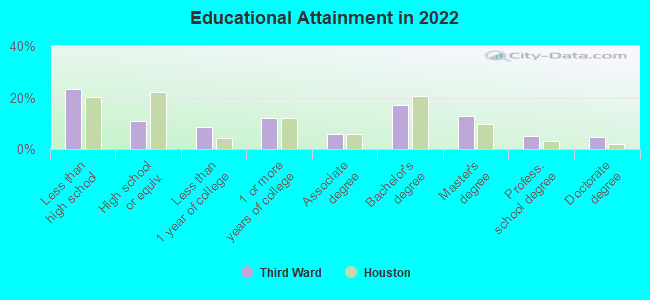
Education in this neighborhood (subdivision or community):
- Percentage of people 3 years and older in K-12 schools:
Third Ward: 22.6% Houston: 16.6%
- Percentage of people 3 years and older in undergraduate colleges:
Third Ward: 35.9% Houston: 4.6%
- Percentage of people 3 years and older in grad. or professional schools:
Third Ward: 6.1% Houston: 1.6%
- Percentage of students K-12 enrolled in private schools:
Third Ward: 19.1% Houston: 9.0%
Percentage of population below poverty level:
| Third Ward: | 37.9% |
| Houston: | 20.7% |
Percentage of married-couple families with both working:
| Third Ward: | 108.2% |
| Houston: | 54.9% |
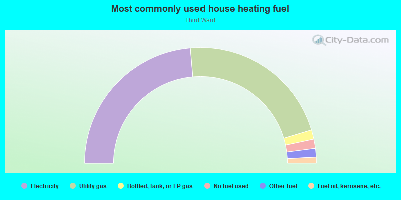
- 47.3%Electricity
- 43.5%Utility gas
- 2.6%Bottled, tank, or LP gas
- 2.6%No fuel used
- 2.4%Other fuel
- 1.7%Fuel oil, kerosene, etc.
Limited-access highways (interstate or state) in this neighborhood:
I- 45 (Gulf Fwy)
Length: 0.77 miles
Directions: E-W, SE-NW
Directions: E-W, SE-NW
Highways in this neighborhood:
State Hwy 35
Length: 1.82 miles
Directions: N-S, SE-NW
Directions: N-S, SE-NW
Eastex Fwy (US Hwy 59)
Length: 0.81 miles
Direction: SW-NE
Address range: 2120 to 2143
Direction: SW-NE
Address range: 2120 to 2143
US Hwy 59 (Southwest Fwy)
Length: 0.51 miles
Directions: E-W, SW-NE
Directions: E-W, SW-NE
South Fwy (State Hwy 288)
Length: 0.19 miles
Direction: SW-NE
Address range: 4826 to 4899
Direction: SW-NE
Address range: 4826 to 4899
Roads and streets:
Elgin St
Length: 2.60 miles
Directions: E-W, N-S, SE-NW
Address range: 2008 to 4499
Directions: E-W, N-S, SE-NW
Address range: 2008 to 4499
Wheeler St
Length: 2.30 miles
Directions: E-W, SE-NW, SW-NE
Address range: 1805 to 4499
Directions: E-W, SE-NW, SW-NE
Address range: 1805 to 4499
Tuam St
Length: 1.80 miles
Directions: E-W, SE-NW, SW-NE
Address range: 1964 to 4199
Directions: E-W, SE-NW, SW-NE
Address range: 1964 to 4199
McGowen St
Length: 1.77 miles
Directions: E-W, N-S, SE-NW
Address range: 2000 to 4099
Directions: E-W, N-S, SE-NW
Address range: 2000 to 4099
Holman St
Length: 1.76 miles
Directions: E-W, SE-NW
Address range: 2000 to 3899
Directions: E-W, SE-NW
Address range: 2000 to 3899
Cleburne St
Length: 1.75 miles
Directions: E-W, SE-NW
Address range: 1800 to 3799
Directions: E-W, SE-NW
Address range: 1800 to 3799
Dennis St
Length: 1.66 miles
Directions: E-W, N-S, SE-NW
Address range: 1700 to 4099
Directions: E-W, N-S, SE-NW
Address range: 1700 to 4099
Drew St
Length: 1.60 miles
Directions: E-W, N-S, SE-NW, SW-NE
Address range: 2000 to 4199
Directions: E-W, N-S, SE-NW, SW-NE
Address range: 2000 to 4199
Anita St
Length: 1.51 miles
Directions: E-W, N-S, SE-NW
Address range: 2300 to 4199
Directions: E-W, N-S, SE-NW
Address range: 2300 to 4199
Live Oak St
Length: 1.46 miles
Direction: SW-NE
Address range: 1900 to 4599
Direction: SW-NE
Address range: 1900 to 4599
Dowling St
Length: 1.46 miles
Direction: SW-NE
Address range: 2000 to 4599
Direction: SW-NE
Address range: 2000 to 4599
Tierwester St
Length: 1.40 miles
Directions: N-S, SW-NE
Address range: 2105 to 4077
Directions: N-S, SW-NE
Address range: 2105 to 4077
Hadley St
Length: 1.40 miles
Directions: E-W, N-S, SE-NW
Address range: 2000 to 3899
Directions: E-W, N-S, SE-NW
Address range: 2000 to 3899
Hutchins St
Length: 1.39 miles
Direction: SW-NE
Address range: 2100 to 4599
Direction: SW-NE
Address range: 2100 to 4599
Rosalie St
Length: 1.37 miles
Directions: E-W, SE-NW
Address range: 2400 to 3899
Directions: E-W, SE-NW
Address range: 2400 to 3899
Alabama St
Length: 1.27 miles
Directions: E-W, SE-NW
Address range: 2000 to 3799
Directions: E-W, SE-NW
Address range: 2000 to 3799
Delano St
Length: 1.26 miles
Direction: SW-NE
Address range: 2400 to 4599
Direction: SW-NE
Address range: 2400 to 4599
St Emanuel St
Length: 1.26 miles
Directions: E-W, N-S, SE-NW, SW-NE
Address range: 2020 to 4685
Directions: E-W, N-S, SE-NW, SW-NE
Address range: 2020 to 4685
Calhoun Rd
Length: 1.24 miles
Directions: E-W, N-S, SE-NW, SW-NE
Address range: 4601 to 4999
Directions: E-W, N-S, SE-NW, SW-NE
Address range: 4601 to 4999
Sampson St
Length: 1.24 miles
Directions: N-S, SW-NE
Address range: 2100 to 4099
Directions: N-S, SW-NE
Address range: 2100 to 4099
McIlhenny St
Length: 1.24 miles
Directions: E-W, SE-NW
Address range: 2000 to 3899
Directions: E-W, SE-NW
Address range: 2000 to 3899
Francis St
Length: 1.17 miles
Directions: E-W, N-S, SE-NW
Address range: 2100 to 3499
Directions: E-W, N-S, SE-NW
Address range: 2100 to 3499
Winbern St
Length: 1.10 miles
Directions: E-W, N-S, SE-NW, SW-NE
Address range: 2000 to 3399
Directions: E-W, N-S, SE-NW, SW-NE
Address range: 2000 to 3399
Scott St
Length: 1.07 miles
Directions: N-S, SW-NE
Address range: 2000 to 3820
Directions: N-S, SW-NE
Address range: 2000 to 3820
Truxillo St
Length: 1.03 miles
Directions: E-W, N-S, SE-NW, SW-NE
Address range: 1800 to 3499
Directions: E-W, N-S, SE-NW, SW-NE
Address range: 1800 to 3499
Nettleton St
Length: 1.03 miles
Directions: N-S, SW-NE
Address range: 2066 to 4099
Directions: N-S, SW-NE
Address range: 2066 to 4099
Webster St
Length: 1.02 miles
Directions: E-W, SE-NW
Address range: 2100 to 3434
Directions: E-W, SE-NW
Address range: 2100 to 3434
Cullen Blvd
Length: 1.00 miles
Directions: N-S, SW-NE
Address range: 2000 to 3999
Directions: N-S, SW-NE
Address range: 2000 to 3999
Rosewood St
Length: 0.99 miles
Directions: E-W, SE-NW
Address range: 2000 to 3659
Directions: E-W, SE-NW
Address range: 2000 to 3659
Burkett St
Length: 0.97 miles
Directions: E-W, N-S, SW-NE
Address range: 2300 to 4099
Directions: E-W, N-S, SW-NE
Address range: 2300 to 4099
Sauer St
Length: 0.95 miles
Directions: N-S, SW-NE
Address range: 2000 to 3799
Directions: N-S, SW-NE
Address range: 2000 to 3799
Bremond St
Length: 0.95 miles
Directions: E-W, SE-NW
Address range: 3000 to 3899
Directions: E-W, SE-NW
Address range: 3000 to 3899
Isabella St
Length: 0.91 miles
Directions: N-S, SE-NW
Address range: 1730 to 3199
Directions: N-S, SE-NW
Address range: 1730 to 3199
Canfield St
Length: 0.88 miles
Directions: N-S, SW-NE
Address range: 2100 to 4049
Directions: N-S, SW-NE
Address range: 2100 to 4049
Gray St
Length: 0.88 miles
Directions: E-W, SE-NW
Address range: 1992 to 3199
Directions: E-W, SE-NW
Address range: 1992 to 3199
Eagle St
Length: 0.88 miles
Directions: E-W, SE-NW
Address range: 2000 to 3799
Directions: E-W, SE-NW
Address range: 2000 to 3799
Bastrop St
Length: 0.87 miles
Direction: SW-NE
Address range: 2100 to 4399
Direction: SW-NE
Address range: 2100 to 4399
Ruth St
Length: 0.85 miles
Directions: E-W, SE-NW
Address range: 2000 to 3599
Directions: E-W, SE-NW
Address range: 2000 to 3599
St Charles St (Saint Charles St)
Length: 0.85 miles
Directions: E-W, SW-NE
Address range: 1900 to 3799
Directions: E-W, SW-NE
Address range: 1900 to 3799
Ennis St
Length: 0.85 miles
Directions: E-W, SW-NE
Address range: 3000 to 4599
Directions: E-W, SW-NE
Address range: 3000 to 4599
Nagle St
Length: 0.82 miles
Directions: N-S, SW-NE
Address range: 2000 to 3799
Directions: N-S, SW-NE
Address range: 2000 to 3799
Berry St
Length: 0.81 miles
Directions: E-W, N-S, SE-NW
Address range: 2000 to 3299
Directions: E-W, N-S, SE-NW
Address range: 2000 to 3299
Briley St
Length: 0.77 miles
Directions: N-S, SW-NE
Address range: 2000 to 4099
Directions: N-S, SW-NE
Address range: 2000 to 4099
Napoleon St
Length: 0.74 miles
Directions: N-S, SW-NE
Address range: 2300 to 3699
Directions: N-S, SW-NE
Address range: 2300 to 3699
Beulah St
Length: 0.72 miles
Directions: E-W, SE-NW
Address range: 3000 to 3899
Directions: E-W, SE-NW
Address range: 3000 to 3899
Simmons St
Length: 0.71 miles
Directions: E-W, SE-NW
Address range: 3000 to 3599
Directions: E-W, SE-NW
Address range: 3000 to 3599
Barbee St
Length: 0.71 miles
Directions: E-W, SE-NW
Address range: 2000 to 3099
Directions: E-W, SE-NW
Address range: 2000 to 3099
Reeves St
Length: 0.67 miles
Direction: E-W
Address range: 3141 to 3599
Direction: E-W
Address range: 3141 to 3599
Velasco St
Length: 0.62 miles
Direction: SW-NE
Address range: 2515 to 3599
Direction: SW-NE
Address range: 2515 to 3599
Chartres St
Length: 0.47 miles
Directions: N-S, SW-NE
Address range: 2144 to 4599
Directions: N-S, SW-NE
Address range: 2144 to 4599
Lucinda St
Length: 0.45 miles
Directions: N-S, SW-NE
Address range: 2200 to 3199
Directions: N-S, SW-NE
Address range: 2200 to 3199
Cobb St
Length: 0.45 miles
Direction: N-S
Address range: 3500 to 3999
Direction: N-S
Address range: 3500 to 3999
Brailsfort St
Length: 0.44 miles
Directions: N-S, SW-NE
Address range: 2300 to 3199
Directions: N-S, SW-NE
Address range: 2300 to 3199
Milby St
Length: 0.44 miles
Directions: N-S, SE-NW, SW-NE
Address range: 2200 to 3399
Directions: N-S, SE-NW, SW-NE
Address range: 2200 to 3399
University Park
Length: 0.43 miles
Directions: E-W, N-S, SE-NW, SW-NE
Directions: E-W, N-S, SE-NW, SW-NE
Adair St
Length: 0.39 miles
Directions: E-W, N-S, SW-NE
Address range: 3116 to 3699
Directions: E-W, N-S, SW-NE
Address range: 3116 to 3699
Callie St
Length: 0.38 miles
Directions: N-S, SW-NE
Address range: 2200 to 3299
Directions: N-S, SW-NE
Address range: 2200 to 3299
E Alabama Ave
Length: 0.38 miles
Direction: E-W
Address range: 3300 to 3799
Direction: E-W
Address range: 3300 to 3799
Trulley St
Length: 0.37 miles
Directions: E-W, SE-NW
Address range: 3000 to 3299
Directions: E-W, SE-NW
Address range: 3000 to 3299
Stuart St
Length: 0.34 miles
Directions: E-W, SE-NW
Address range: 2000 to 2599
Directions: E-W, SE-NW
Address range: 2000 to 2599
Leek St
Length: 0.30 miles
Directions: E-W, N-S, SW-NE
Address range: 2400 to 3099
Directions: E-W, N-S, SW-NE
Address range: 2400 to 3099
Susan Ann Ct
Length: 0.27 miles
Directions: E-W, N-S, SE-NW, SW-NE
Address range: 1 to 99
Directions: E-W, N-S, SE-NW, SW-NE
Address range: 1 to 99
Attucks St
Length: 0.26 miles
Direction: N-S
Address range: 3500 to 3999
Direction: N-S
Address range: 3500 to 3999
Reading
Length: 0.26 miles
Directions: E-W, SE-NW
Directions: E-W, SE-NW
Chenevert St
Length: 0.25 miles
Direction: SW-NE
Address range: 3900 to 4399
Direction: SW-NE
Address range: 3900 to 4399
Paige St
Length: 0.22 miles
Direction: SW-NE
Address range: 2900 to 3299
Direction: SW-NE
Address range: 2900 to 3299
S Lockwood Dr
Length: 0.21 miles
Directions: E-W, SW-NE
Address range: 2101 to 2299
Directions: E-W, SW-NE
Address range: 2101 to 2299
Pierce St
Length: 0.21 miles
Direction: SE-NW
Address range: 2400 to 2599
Direction: SE-NW
Address range: 2400 to 2599
Francis
Length: 0.19 miles
Directions: E-W, SE-NW
Directions: E-W, SE-NW
Sanders St
Length: 0.18 miles
Directions: E-W, SW-NE
Address range: 3300 to 3699
Directions: E-W, SW-NE
Address range: 3300 to 3699
Beulah
Length: 0.18 miles
Direction: E-W
Direction: E-W
Roberts St
Length: 0.17 miles
Directions: N-S, SW-NE
Address range: 1962 to 2399
Directions: N-S, SW-NE
Address range: 1962 to 2399
Cougar Pl
Length: 0.17 miles
Directions: E-W, N-S, SW-NE
Directions: E-W, N-S, SW-NE
Drew
Length: 0.16 miles
Direction: E-W
Direction: E-W
Anita
Length: 0.16 miles
Direction: E-W
Direction: E-W
Tuam
Length: 0.16 miles
Direction: E-W
Direction: E-W
Division St
Length: 0.14 miles
Direction: SE-NW
Address range: 2400 to 2599
Direction: SE-NW
Address range: 2400 to 2599
Nalle St
Length: 0.14 miles
Directions: N-S, SW-NE
Address range: 3400 to 3599
Directions: N-S, SW-NE
Address range: 3400 to 3599
Cuney Dr
Length: 0.12 miles
Direction: N-S
Address range: 3900 to 4099
Direction: N-S
Address range: 3900 to 4099
Palmer St
Length: 0.12 miles
Direction: SW-NE
Address range: 3500 to 3799
Direction: SW-NE
Address range: 3500 to 3799
Rose Ct
Length: 0.10 miles
Direction: SE-NW
Address range: 1 to 99
Direction: SE-NW
Address range: 1 to 99
Hamilton St
Length: 0.10 miles
Direction: SW-NE
Address range: 3900 to 4099
Direction: SW-NE
Address range: 3900 to 4099
Milby
Length: 0.09 miles
Directions: N-S, SW-NE
Directions: N-S, SW-NE
Elgin Ct
Length: 0.07 miles
Direction: N-S
Address range: 3300 to 3399
Direction: N-S
Address range: 3300 to 3399
Sheppard Rd
Length: 0.07 miles
Direction: SE-NW
Address range: 1 to 99
Direction: SE-NW
Address range: 1 to 99
Calhoun-Pease
Length: 0.07 miles
Directions: N-S, SE-NW
Directions: N-S, SE-NW
Rugley St
Length: 0.06 miles
Direction: E-W
Address range: 3400 to 3499
Direction: E-W
Address range: 3400 to 3499
Callie
Length: 0.06 miles
Direction: N-S
Direction: N-S
Webster
Length: 0.06 miles
Directions: E-W, N-S, SE-NW
Directions: E-W, N-S, SE-NW
Mc Ilhenny
Length: 0.06 miles
Directions: E-W, SE-NW
Directions: E-W, SE-NW
Chaco St
Length: 0.05 miles
Direction: SE-NW
Address range: 2703 to 2799
Direction: SE-NW
Address range: 2703 to 2799
Gray Ct
Length: 0.05 miles
Direction: E-W
Direction: E-W
Alabama
Length: 0.05 miles
Direction: E-W
Direction: E-W
Naplava St
Length: 0.05 miles
Direction: E-W
Address range: 3500 to 3599
Direction: E-W
Address range: 3500 to 3599
Sauer Aly
Length: 0.05 miles
Direction: E-W
Address range: 3300 to 3399
Direction: E-W
Address range: 3300 to 3399
Jones Ct
Length: 0.04 miles
Direction: SE-NW
Address range: 2400 to 2499
Direction: SE-NW
Address range: 2400 to 2499
Lockwood Dr
Length: 0.04 miles
Direction: SW-NE
Direction: SW-NE
Overton Ct
Length: 0.04 miles
Direction: SW-NE
Address range: 1 to 99
Direction: SW-NE
Address range: 1 to 99
Adair
Length: 0.03 miles
Direction: E-W
Direction: E-W
Live Oak Ct
Length: 0.03 miles
Direction: SE-NW
Address range: 2100 to 2199
Direction: SE-NW
Address range: 2100 to 2199
Simmons Ct
Length: 0.03 miles
Direction: SW-NE
Address range: 1 to 99
Direction: SW-NE
Address range: 1 to 99
University Oaks Blvd
Length: 0.03 miles
Direction: N-S
Direction: N-S
Blodgett St
Length: 0.03 miles
Direction: E-W
Address range: 3386 to 3431
Direction: E-W
Address range: 3386 to 3431
Francis Ct
Length: 0.02 miles
Direction: N-S
Address range: 3300 to 3399
Direction: N-S
Address range: 3300 to 3399
Railroad features:
at and Sf Rlwy
Length: 2.21 miles
Directions: N-S, SE-NW
Directions: N-S, SE-NW
Houston Belt and Terminal Rlwy
Length: 1.45 miles
Directions: E-W, N-S, SW-NE
Directions: E-W, N-S, SW-NE
Southern Pacific RR
Length: 0.30 miles
Direction: SW-NE
Direction: SW-NE
Other features:
Brays Byu
Length: 0.07 miles
Direction: SW-NE
Direction: SW-NE