Tienken (Adams-Tienken) neighborhood in Rochester, Michigan (MI), 48309, 48306 detailed profile
Settings
X


Business Search - 14 Million verified businesses
Area: 2.134 square miles
Population: 6,754
Population density:
| Tienken (Adams-Tienken): | 3,165 people per square mile |
| Rochester: | 3,361 people per square mile |

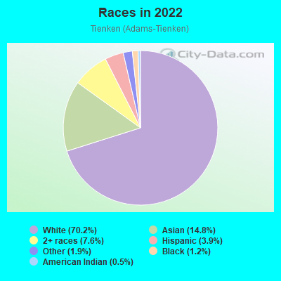
- 4,90570.2%White
- 1,03314.8%Asian
- 5317.6%Two or more races
- 2693.9%Hispanic or Latino
- 1321.9%Some other race
- 821.2%Black
- 330.5%American Indian
Median household income in 2022:
| Tienken (Adams-Tienken): | $153,667 |
| Rochester: | $102,838 |
Distribution of median household income
![Distribution of median household income]()
- 64Less than $10,000
- 174$10,000 to $19,999
- 137$20,000 to $29,999
- 102$30,000 to $39,999
- 199$40,000 to $49,999
- 58$50,000 to $59,999
- 90$60,000 to $74,999
- 119$75,000 to $99,999
- 432$100,000 to $124,999
- 328$125,000 to $149,999
- 314$150,000 to $199,999
- 804$200,000 or more

Distribution of owner-occupied house/condo value
![Distribution of owner-occupied house/condo value]()
- 98Less than $50,000
- 157$50,000 to $99,999
- 261$100,000 to $149,999
- 184$150,000 to $199,999
- 68$200,000 to $249,999
- 85$250,000 to $299,999
- 393$300,000 to $399,999
- 857$400,000 to $499,999
- 630$500,000 to $749,999
- 66$750,000 to $999,999
- 127$1,000,000 or more

Distribution of rent paid by renters
![Distribution of rent paid by renters]()
- 109Less than $100
- 792$200 to $299
- 100$300 to $399
- 318$400 to $499
- 67$600 to $699
- 113$700 to $799
- 50$800 to $899
- 132$900 to $999
- 157$1,000 to $1,249
- 19$1,250 to $1,499
- 45$1,500 to $1,999
- 421$2,000 or more

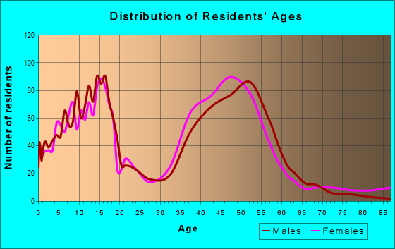
| Males: | 3,359 |
| Females: | 3,394 |
Males:
| This neighborhood: | 42.8 years |
| Whole city: | 37.4 years |
| This neighborhood: | 43.1 years |
| Whole city: | 42.4 years |
Average household size:
| Tienken (Adams-Tienken): | 5.4 people |
| Rochester: | 2.4 people |
Percentage of family households:
| Tienken (Adams-Tienken): | 54.8% |
| Rochester: | 49.8% |
| Here: | 72.0% |
| Rochester: | 51.6% |
Percentage of married-couple families with children (among all households):
| Tienken (Adams-Tienken): | 31.5% |
| Rochester: | 35.7% |
Percentage of single-mother households (among all households):
| Tienken (Adams-Tienken): | 2.8% |
| Rochester: | 6.3% |
Percentage of never married males 15 years old and over:
Percentage of never married females 15 years old and over:
| Tienken (Adams-Tienken): | 11.7% |
| Rochester: | 15.9% |
Percentage of never married females 15 years old and over:
| Tienken (Adams-Tienken): | 11.0% |
| city: | 14.1% |
Percentage of people that speak English not well or not at all:
| Tienken (Adams-Tienken): | 1.7% |
| Rochester: | 1.1% |
Percentage of people born in this state:
Percentage of people born in another U.S. state:
Percentage of native residents but born outside the U.S.:
Percentage of foreign born residents:
| Here: | 54.0% |
| Rochester: | 69.7% |
Percentage of people born in another U.S. state:
| Tienken (Adams-Tienken): | 21.1% |
| Rochester: | 16.8% |
Percentage of native residents but born outside the U.S.:
| Here: | 3.7% |
| city: | 1.8% |
Percentage of foreign born residents:
| Here: | 21.2% |
| Rochester: | 11.7% |
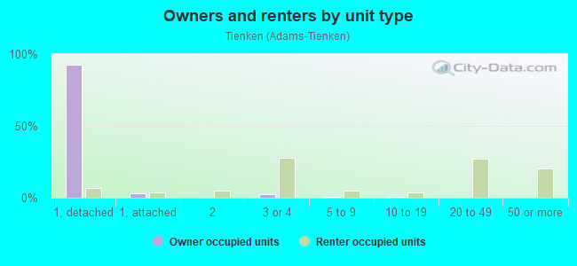
Owner-occupied
Renter-occupied

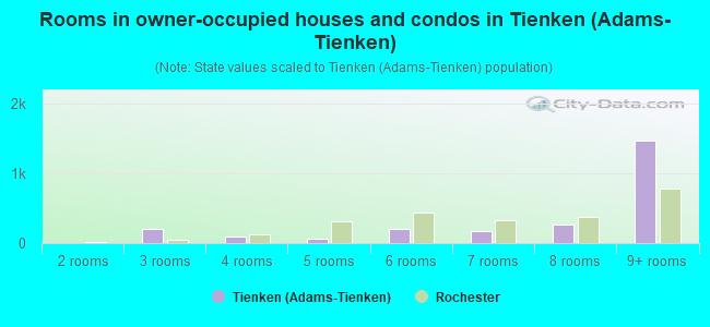
- Rooms in owner-occupied houses and condos in Tienken <
> - 01 room
- 02 rooms
- 2023 rooms
- 874 rooms
- 665 rooms
- 1976 rooms
- 1727 rooms
- 2648 rooms
- 1,4749+ rooms
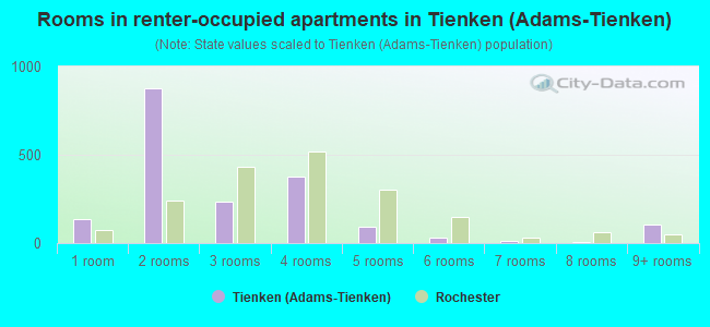
- Rooms in renter-occupied apartments in Tienken <
> - 1371 room
- 8742 rooms
- 2333 rooms
- 3744 rooms
- 915 rooms
- 336 rooms
- 127 rooms
- 88 rooms
- 1059+ rooms
Owner-occupied
Renter-occupied
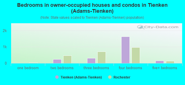
- Bedrooms in owner-occupied houses and condos in Tienken <
> - 0no bedroom
- 01 bedroom
- 2442 bedrooms
- 3213 bedrooms
- 1,6344 bedrooms
- 1495+ bedrooms
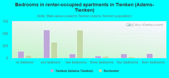
- Bedrooms in renter-occupied apartments in Tienken <
> - 137no bedroom
- 5741 bedroom
- 852 bedrooms
- 433 bedrooms
- 834 bedrooms
- 925+ bedrooms
Average number of cars or other vehicles available in houses/condos:
Average number of cars or other vehicles available in apartments:
| This neighborhood: | 2.1 |
| Rochester: | 2.0 |
Average number of cars or other vehicles available in apartments:
| Here: | |
| city: |
Percentage of units with a mortgage:
| Tienken (Adams-Tienken): | 69.1% |
| Rochester: | 62.4% |
Average estimated value of detached houses in 2022 (88.6% of all units):
| Tienken (Adams-Tienken): | $524,750 |
| Michigan: | $280,038 |
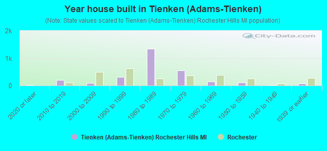
- Year house built in Tienken <
> - 152020 or later
- 2082010 to 2019
- 932000 to 2009
- 3081990 to 1999
- 1,3461980 to 1989
- 5441970 to 1979
- 1431960 to 1969
- 1051950 to 1959
- 171940 to 1949
- 671939 or earlier
City-data.com crime index for city in 2020 (higher means more crime):
| City: | 38.6 |
| U.S. average: | 219.5 |
Travel time to work (commute)
![Travel time to work (commute)]()
- 22Less than 5 minutes
- 1825 to 9 minutes
- 24710 to 14 minutes
- 60515 to 19 minutes
- 46520 to 24 minutes
- 13525 to 29 minutes
- 29030 to 34 minutes
- 7435 to 39 minutes
- 11540 to 44 minutes
- 22245 to 59 minutes
- 9460 to 89 minutes
- 4690 or more minutes

Means of transportation to work
![Means of transportation to work]()
- 76.6%2,305Drove a car alone
- 6.1%185Carpooled
- 2.5%76Walked
- 1.4%43Other means
- 17.2%517Worked at home

Time leaving home to go to work
![Time leaving home to go to work]()
- 2712:00 a.m. to 4:59 a.m.
- 255:00 a.m. to 5:29 a.m.
- 735:30 a.m. to 5:59 a.m.
- 2336:00 a.m. to 6:29 a.m.
- 2766:30 a.m. to 6:59 a.m.
- 3907:00 a.m. to 7:29 a.m.
- 3157:30 a.m. to 7:59 a.m.
- 4988:00 a.m. to 8:29 a.m.
- 1778:30 a.m. to 8:59 a.m.
- 2169:00 a.m. to 9:59 a.m.
- 4510:00 a.m. to 10:59 a.m.
- 6911:00 a.m. to 11:59 a.m.
- 9012:00 p.m. to 3:59 p.m.
- 764:00 p.m. to 11:59 p.m.

Occupations of males:
- Percentage of males in management occupations (except farmers):
Here: 20.9% city: 21.7%
- Percentage of males in business and financial operations occupations:
Here: 12.1% city: 8.2%
- Percentage of males in computer and mathematical occupations:
Here: 7.1% city: 5.8%
- Percentage of males in architecture and engineering occupations:
Here: 18.3% city: 12.6%
- Percentage of males in community and social services occupations:
Here: 1.1% city: 0.0%
- Percentage of males in legal occupations:
Here: 1.4% city: 0.7%
- Percentage of males in education, training, and library occupations:
Here: 4.6% city: 2.9%
- Percentage of males in arts, design, entertainment, sports, and media occupations:
Here: 2.2% city: 1.7%
- Percentage of males in healthcare practitioners and technical occupations:
Here: 3.8% city: 5.7%
- Percentage of males in service occupations:
Here: 6.4% city: 9.8%
- Percentage of males in sales and office occupations:
Here: 13.1% city: 14.1%
- Percentage of males in construction, extraction, and maintenance occupations:
Here: 1.7% city: 4.4%
- Percentage of males in material moving occupations:
Here: 3.1% city: 5.9%
Occupations of females:
- Percentage of females in management occupations (except farmers):
Here: 11.3% city: 17.7%
- Percentage of females in business and financial operations occupations:
Here: 23.3% city: 9.8%
- Percentage of females in computer and mathematical occupations:
Here: 4.4% city: 2.7%
- Percentage of females in architecture and engineering occupations:
Here: 3.1% city: 1.1%
- Percentage of females in community and social services occupations:
Here: 2.6% city: 2.0%
- Percentage of females in education, training, and library occupations:
Here: 13.5% city: 11.0%
- Percentage of females in arts, design, entertainment, sports, and media occupations:
Here: 4.5% city: 1.0%
- Percentage of females in healthcare practitioners and technical occupations:
Here: 7.4% city: 14.0%
- Percentage of females in service occupations:
Here: 6.6% city: 10.0%
- Percentage of females in sales and office occupations:
Here: 19.9% city: 21.7%
- Percentage of females in material moving occupations:
Here: 1.4% city: 0.9%
Percentage of people 16-64 in Armed Forces:
| Tienken (Adams-Tienken): | 0.2% |
| Rochester: | 0.3% |
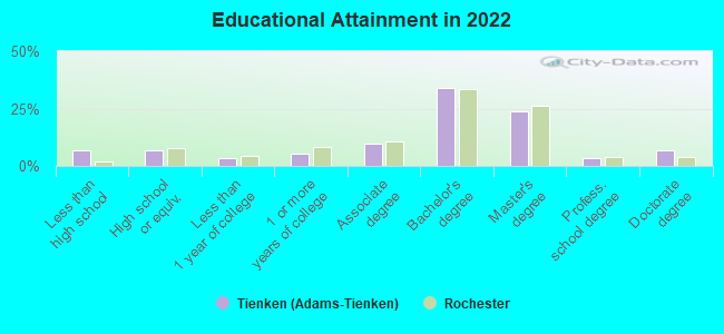
Education in this neighborhood (subdivision or community):
- Percentage of people 3 years and older in K-12 schools:
Tienken (Adams-Tienken): 23.2% Rochester: 17.0%
- Percentage of people 3 years and older in undergraduate colleges:
Tienken (Adams-Tienken): 3.1% Rochester: 6.8%
- Percentage of people 3 years and older in grad. or professional schools:
Tienken (Adams-Tienken): 1.3% Rochester: 2.5%
- Percentage of students K-12 enrolled in private schools:
Tienken (Adams-Tienken): 22.0% Rochester: 15.7%
Percentage of population below poverty level:
| Tienken (Adams-Tienken): | 2.0% |
| Rochester: | 6.0% |
Median year owner moved in (as recorded in 2022):
| Tienken (Adams-Tienken): | 2004 |
| Rochester: | 2010 |
Percentage of married-couple families with both working:
| Tienken (Adams-Tienken): | 70.1% |
| Rochester: | 57.8% |
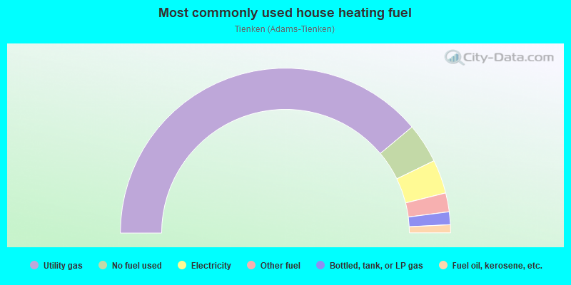
- 77.7%Utility gas
- 7.8%No fuel used
- 6.6%Electricity
- 3.7%Other fuel
- 2.5%Bottled, tank, or LP gas
- 1.6%Fuel oil, kerosene, etc.
Roads and streets:
Walton Blvd
Length: 2.49 miles
Direction: E-W
Direction: E-W
N Adams Rd
Length: 2.03 miles
Direction: N-S
Address range: 1 to 1999
Direction: N-S
Address range: 1 to 1999
Raintree Dr
Length: 1.33 miles
Directions: E-W, SE-NW, SW-NE
Address range: 3000 to 3999
Directions: E-W, SE-NW, SW-NE
Address range: 3000 to 3999
Dutton Rd
Length: 1.27 miles
Direction: E-W
Address range: 3000 to 3958
Direction: E-W
Address range: 3000 to 3958
W Tienken Rd
Length: 1.25 miles
Direction: E-W
Address range: 3000 to 3999
Direction: E-W
Address range: 3000 to 3999
Salem Dr
Length: 1.18 miles
Directions: E-W, N-S, SE-NW, SW-NE
Address range: 3016 to 3699
Directions: E-W, N-S, SE-NW, SW-NE
Address range: 3016 to 3699
Charlwood Dr
Length: 1.15 miles
Directions: E-W, SW-NE
Address range: 3000 to 3699
Directions: E-W, SW-NE
Address range: 3000 to 3699
Summit Ridge Dr
Length: 1.10 miles
Directions: E-W, N-S, SE-NW, SW-NE
Address range: 3001 to 3796
Directions: E-W, N-S, SE-NW, SW-NE
Address range: 3001 to 3796
Burhaven Dr (Hollenshade)
Length: 0.80 miles
Directions: E-W, N-S, SW-NE
Address range: 1300 to 3699
Directions: E-W, N-S, SW-NE
Address range: 1300 to 3699
Edinborough Dr
Length: 0.78 miles
Directions: E-W, N-S, SE-NW, SW-NE
Address range: 1676 to 3799
Directions: E-W, N-S, SE-NW, SW-NE
Address range: 1676 to 3799
Stonetree Cir
Length: 0.74 miles
Directions: E-W, N-S, SE-NW, SW-NE
Address range: 13 to 270
Directions: E-W, N-S, SE-NW, SW-NE
Address range: 13 to 270
Firewood Dr
Length: 0.69 miles
Directions: N-S, SE-NW, SW-NE
Address range: 1 to 876
Directions: N-S, SE-NW, SW-NE
Address range: 1 to 876
Rose Brier Dr
Length: 0.67 miles
Directions: E-W, N-S, SE-NW, SW-NE
Address range: 39 to 367
Directions: E-W, N-S, SE-NW, SW-NE
Address range: 39 to 367
Shellbourne Dr
Length: 0.66 miles
Directions: E-W, N-S, SE-NW, SW-NE
Address range: 300 to 652
Directions: E-W, N-S, SE-NW, SW-NE
Address range: 300 to 652
Palm Aire Dr
Length: 0.59 miles
Directions: E-W, SE-NW, SW-NE
Address range: 3000 to 3499
Directions: E-W, SE-NW, SW-NE
Address range: 3000 to 3499
Snowden Cir
Length: 0.49 miles
Directions: E-W, N-S, SE-NW, SW-NE
Address range: 1646 to 2746
Directions: E-W, N-S, SE-NW, SW-NE
Address range: 1646 to 2746
Gunder Dr
Length: 0.48 miles
Directions: E-W, N-S, SW-NE
Address range: 100 to 499
Directions: E-W, N-S, SW-NE
Address range: 100 to 499
Jason Cir
Length: 0.47 miles
Directions: E-W, N-S, SE-NW, SW-NE
Address range: 1700 to 1875
Directions: E-W, N-S, SE-NW, SW-NE
Address range: 1700 to 1875
Olympia Dr
Length: 0.45 miles
Directions: E-W, N-S, SE-NW
Address range: 1000 to 1599
Directions: E-W, N-S, SE-NW
Address range: 1000 to 1599
Rolling Green Cir (Rolling Green Cir N)
Length: 0.44 miles
Directions: N-S, SE-NW, SW-NE
Address range: 300 to 654
Directions: N-S, SE-NW, SW-NE
Address range: 300 to 654
Bellarmine Dr
Length: 0.44 miles
Direction: N-S
Address range: 1 to 499
Direction: N-S
Address range: 1 to 499
Wedgewood Dr
Length: 0.44 miles
Directions: E-W, N-S, SW-NE
Address range: 3400 to 3599
Directions: E-W, N-S, SW-NE
Address range: 3400 to 3599
Edmunton Dr
Length: 0.44 miles
Directions: E-W, SE-NW, SW-NE
Address range: 3300 to 3443
Directions: E-W, SE-NW, SW-NE
Address range: 3300 to 3443
Innsbrook Dr
Length: 0.43 miles
Directions: E-W, N-S, SE-NW, SW-NE
Address range: 3300 to 3480
Directions: E-W, N-S, SE-NW, SW-NE
Address range: 3300 to 3480
Aquinas Dr
Length: 0.41 miles
Directions: E-W, SW-NE
Address range: 3200 to 3499
Directions: E-W, SW-NE
Address range: 3200 to 3499
Bay Point Dr
Length: 0.41 miles
Directions: E-W, SE-NW, SW-NE
Address range: 3000 to 3299
Directions: E-W, SE-NW, SW-NE
Address range: 3000 to 3299
Parkwood Dr
Length: 0.40 miles
Direction: E-W
Address range: 3200 to 3299
Direction: E-W
Address range: 3200 to 3299
Meadownbrook Rd (N Meadowbrook)
Length: 0.40 miles
Direction: E-W
Direction: E-W
Merriweather Ln
Length: 0.39 miles
Directions: E-W, SW-NE
Address range: 3600 to 3799
Directions: E-W, SW-NE
Address range: 3600 to 3799
Antoinette Dr
Length: 0.39 miles
Directions: E-W, N-S, SE-NW, SW-NE
Address range: 248 to 461
Directions: E-W, N-S, SE-NW, SW-NE
Address range: 248 to 461
Arbor Creek Dr
Length: 0.38 miles
Directions: E-W, N-S, SE-NW
Address range: 1327 to 1615
Directions: E-W, N-S, SE-NW
Address range: 1327 to 1615
Newcastle Dr
Length: 0.38 miles
Directions: E-W, N-S, SE-NW
Address range: 3600 to 3799
Directions: E-W, N-S, SE-NW
Address range: 3600 to 3799
Chaffer Dr
Length: 0.38 miles
Directions: E-W, N-S, SE-NW, SW-NE
Address range: 1100 to 1299
Directions: E-W, N-S, SE-NW, SW-NE
Address range: 1100 to 1299
Tammaron Dr
Length: 0.37 miles
Directions: E-W, N-S, SE-NW, SW-NE
Address range: 3101 to 3272
Directions: E-W, N-S, SE-NW, SW-NE
Address range: 3101 to 3272
Kingspath Dr
Length: 0.36 miles
Directions: N-S, SE-NW
Address range: 1303 to 1399
Directions: N-S, SE-NW
Address range: 1303 to 1399
Medinah Dr
Length: 0.36 miles
Directions: N-S, SE-NW
Address range: 700 to 961
Directions: N-S, SE-NW
Address range: 700 to 961
Old Homestead Dr
Length: 0.36 miles
Directions: N-S, SE-NW, SW-NE
Address range: 1608 to 1890
Directions: N-S, SE-NW, SW-NE
Address range: 1608 to 1890
Englewood Dr
Length: 0.36 miles
Directions: E-W, N-S, SE-NW, SW-NE
Address range: 734 to 999
Directions: E-W, N-S, SE-NW, SW-NE
Address range: 734 to 999
Aynsley Dr
Length: 0.35 miles
Directions: E-W, N-S, SW-NE
Address range: 3500 to 3687
Directions: E-W, N-S, SW-NE
Address range: 3500 to 3687
Silvervale Dr
Length: 0.34 miles
Directions: E-W, N-S, SE-NW, SW-NE
Address range: 300 to 453
Directions: E-W, N-S, SE-NW, SW-NE
Address range: 300 to 453
Kilburn Rd W
Length: 0.33 miles
Directions: E-W, SE-NW
Address range: 3000 to 3299
Directions: E-W, SE-NW
Address range: 3000 to 3299
Rosewood Ln
Length: 0.32 miles
Directions: E-W, SE-NW
Address range: 3700 to 3899
Directions: E-W, SE-NW
Address range: 3700 to 3899
Donegal Dr
Length: 0.32 miles
Directions: E-W, N-S, SW-NE
Address range: 200 to 499
Directions: E-W, N-S, SW-NE
Address range: 200 to 499
Plum Ridge Dr
Length: 0.31 miles
Directions: E-W, N-S, SE-NW, SW-NE
Address range: 566 to 699
Directions: E-W, N-S, SE-NW, SW-NE
Address range: 566 to 699
Pinehurst Dr
Length: 0.30 miles
Directions: N-S, SW-NE
Address range: 400 to 599
Directions: N-S, SW-NE
Address range: 400 to 599
Cedar Shake Dr
Length: 0.29 miles
Directions: E-W, SW-NE
Address range: 3500 to 3699
Directions: E-W, SW-NE
Address range: 3500 to 3699
Falcon Dr
Length: 0.28 miles
Directions: N-S, SE-NW, SW-NE
Address range: 700 to 883
Directions: N-S, SE-NW, SW-NE
Address range: 700 to 883
Doral Dr
Length: 0.27 miles
Directions: E-W, SE-NW
Address range: 3122 to 3299
Directions: E-W, SE-NW
Address range: 3122 to 3299
Dunedin Dr
Length: 0.27 miles
Directions: E-W, N-S, SE-NW, SW-NE
Address range: 700 to 880
Directions: E-W, N-S, SE-NW, SW-NE
Address range: 700 to 880
Coachwood Ln
Length: 0.26 miles
Directions: E-W, N-S, SW-NE
Address range: 3700 to 3899
Directions: E-W, N-S, SW-NE
Address range: 3700 to 3899
Cobridge Dr
Length: 0.25 miles
Directions: N-S, SE-NW, SW-NE
Address range: 1100 to 1299
Directions: N-S, SE-NW, SW-NE
Address range: 1100 to 1299
Rolling Green Cir S
Length: 0.24 miles
Directions: E-W, N-S, SE-NW
Address range: 3023 to 3239
Directions: E-W, N-S, SE-NW
Address range: 3023 to 3239
Tacoma Dr
Length: 0.24 miles
Directions: N-S, SE-NW, SW-NE
Address range: 1300 to 1599
Directions: N-S, SE-NW, SW-NE
Address range: 1300 to 1599
Cherrywood Ct
Length: 0.23 miles
Directions: E-W, N-S, SE-NW, SW-NE
Directions: E-W, N-S, SE-NW, SW-NE
Teakwood Ln
Length: 0.22 miles
Directions: E-W, SE-NW
Address range: 3700 to 3999
Directions: E-W, SE-NW
Address range: 3700 to 3999
Rocky Crest Dr
Length: 0.22 miles
Directions: E-W, N-S, SW-NE
Address range: 3300 to 3473
Directions: E-W, N-S, SW-NE
Address range: 3300 to 3473
Cherrywood Ln
Length: 0.21 miles
Direction: E-W
Address range: 3800 to 3899
Direction: E-W
Address range: 3800 to 3899
Sherborn Dr
Length: 0.20 miles
Directions: E-W, SW-NE
Address range: 3551 to 3599
Directions: E-W, SW-NE
Address range: 3551 to 3599
Quincy Dr
Length: 0.19 miles
Directions: N-S, SW-NE
Address range: 1756 to 1839
Directions: N-S, SW-NE
Address range: 1756 to 1839
Oakpointe Dr
Length: 0.19 miles
Directions: N-S, SE-NW, SW-NE
Address range: 1900 to 3999
Directions: N-S, SE-NW, SW-NE
Address range: 1900 to 3999
Fordcroft Dr
Length: 0.19 miles
Directions: N-S, SE-NW
Address range: 300 to 422
Directions: N-S, SE-NW
Address range: 300 to 422
Middlebury Ln
Length: 0.17 miles
Directions: E-W, N-S, SW-NE
Address range: 515 to 662
Directions: E-W, N-S, SW-NE
Address range: 515 to 662
Pepper Tree Ln
Length: 0.17 miles
Directions: N-S, SE-NW, SW-NE
Address range: 201 to 298
Directions: N-S, SE-NW, SW-NE
Address range: 201 to 298
Wakefield Ct
Length: 0.17 miles
Directions: E-W, N-S, SE-NW, SW-NE
Address range: 1500 to 1699
Directions: E-W, N-S, SE-NW, SW-NE
Address range: 1500 to 1699
Palm Aire Ct
Length: 0.17 miles
Directions: E-W, SE-NW, SW-NE
Address range: 3116 to 3444
Directions: E-W, SE-NW, SW-NE
Address range: 3116 to 3444
Monica Ct
Length: 0.17 miles
Directions: E-W, N-S, SW-NE
Address range: 1519 to 1589
Directions: E-W, N-S, SW-NE
Address range: 1519 to 1589
Aynsley
Length: 0.14 miles
Direction: E-W
Address range: 3600 to 3699
Direction: E-W
Address range: 3600 to 3699
Hidden Creek Ct
Length: 0.14 miles
Directions: E-W, N-S, SE-NW, SW-NE
Address range: 3772 to 3998
Directions: E-W, N-S, SE-NW, SW-NE
Address range: 3772 to 3998
Oakpointe Ct
Length: 0.14 miles
Directions: E-W, N-S, SW-NE
Address range: 3900 to 3999
Directions: E-W, N-S, SW-NE
Address range: 3900 to 3999
Independence Ct
Length: 0.13 miles
Directions: E-W, N-S, SE-NW, SW-NE
Address range: 1900 to 1963
Directions: E-W, N-S, SE-NW, SW-NE
Address range: 1900 to 1963
Doral Ct
Length: 0.13 miles
Directions: E-W, SW-NE
Address range: 3122 to 3299
Directions: E-W, SW-NE
Address range: 3122 to 3299
Sunbury Ct
Length: 0.12 miles
Direction: E-W
Address range: 3046 to 3199
Direction: E-W
Address range: 3046 to 3199
Waltonshire Ct
Length: 0.12 miles
Direction: N-S
Address range: 1 to 99
Direction: N-S
Address range: 1 to 99
Sherborn Ct
Length: 0.11 miles
Directions: E-W, N-S, SE-NW
Address range: 1328 to 1377
Directions: E-W, N-S, SE-NW
Address range: 1328 to 1377
Whitehouse Ct
Length: 0.11 miles
Directions: N-S, SE-NW
Address range: 1300 to 1399
Directions: N-S, SE-NW
Address range: 1300 to 1399
Brandon Ct
Length: 0.11 miles
Direction: E-W
Address range: 3048 to 3168
Direction: E-W
Address range: 3048 to 3168
Burlington Dr
Length: 0.11 miles
Directions: N-S, SE-NW, SW-NE
Address range: 3061 to 3122
Directions: N-S, SE-NW, SW-NE
Address range: 3061 to 3122
Lakewood Dr
Length: 0.10 miles
Directions: N-S, SW-NE
Address range: 700 to 899
Directions: N-S, SW-NE
Address range: 700 to 899
Sudbury Ct
Length: 0.10 miles
Direction: N-S
Address range: 1800 to 1899
Direction: N-S
Address range: 1800 to 1899
Independence Dr
Length: 0.10 miles
Directions: E-W, N-S, SE-NW
Address range: 1900 to 1999
Directions: E-W, N-S, SE-NW
Address range: 1900 to 1999
Mc Cormick
Length: 0.10 miles
Directions: N-S, SE-NW, SW-NE
Address range: 1874 to 1946
Directions: N-S, SE-NW, SW-NE
Address range: 1874 to 1946
Hartford Ct
Length: 0.09 miles
Directions: E-W, SW-NE
Address range: 3100 to 3157
Directions: E-W, SW-NE
Address range: 3100 to 3157
Crestwood Ln
Length: 0.09 miles
Direction: N-S
Address range: 700 to 899
Direction: N-S
Address range: 700 to 899
Gunder Ct
Length: 0.08 miles
Direction: SE-NW
Address range: 200 to 314
Direction: SE-NW
Address range: 200 to 314
Holiday Ct
Length: 0.08 miles
Directions: E-W, SE-NW
Address range: 3500 to 3553
Directions: E-W, SE-NW
Address range: 3500 to 3553
Baroque Ct
Length: 0.08 miles
Direction: E-W
Address range: 3400 to 3423
Direction: E-W
Address range: 3400 to 3423
Old Ridge Ct
Length: 0.08 miles
Directions: N-S, SE-NW
Address range: 301 to 371
Directions: N-S, SE-NW
Address range: 301 to 371
Williamsburg Ct
Length: 0.08 miles
Directions: E-W, SW-NE
Address range: 3800 to 3899
Directions: E-W, SW-NE
Address range: 3800 to 3899
Saratoga Dr
Length: 0.07 miles
Directions: E-W, SW-NE
Address range: 3000 to 3099
Directions: E-W, SW-NE
Address range: 3000 to 3099
Muirwood Ct
Length: 0.07 miles
Directions: N-S, SE-NW
Address range: 1238 to 1340
Directions: N-S, SE-NW
Address range: 1238 to 1340
Heatherwood Ct
Length: 0.07 miles
Direction: E-W
Address range: 3600 to 3699
Direction: E-W
Address range: 3600 to 3699
Worthington Ct
Length: 0.07 miles
Direction: E-W
Address range: 3600 to 3699
Direction: E-W
Address range: 3600 to 3699
Royal Doulton Blvd
Length: 0.07 miles
Directions: N-S, SE-NW
Address range: 1018 to 1052
Directions: N-S, SE-NW
Address range: 1018 to 1052
Michele Ct
Length: 0.06 miles
Directions: N-S, SW-NE
Address range: 1300 to 1381
Directions: N-S, SW-NE
Address range: 1300 to 1381
Newcastle Ct
Length: 0.06 miles
Directions: N-S, SW-NE
Address range: 1600 to 1699
Directions: N-S, SW-NE
Address range: 1600 to 1699
Wales
Length: 0.06 miles
Directions: N-S, SE-NW
Address range: 1971 to 1999
Directions: N-S, SE-NW
Address range: 1971 to 1999
Burlington
Length: 0.06 miles
Direction: E-W
Address range: 3089 to 3124
Direction: E-W
Address range: 3089 to 3124
Albany Dr
Length: 0.06 miles
Directions: E-W, SE-NW
Address range: 3300 to 3335
Directions: E-W, SE-NW
Address range: 3300 to 3335
Summit Ct
Length: 0.06 miles
Direction: SW-NE
Address range: 3731 to 3757
Direction: SW-NE
Address range: 3731 to 3757
Homestead Ct
Length: 0.05 miles
Direction: SW-NE
Address range: 931 to 998
Direction: SW-NE
Address range: 931 to 998
Old Tree Ct
Length: 0.05 miles
Direction: SE-NW
Address range: 3600 to 3699
Direction: SE-NW
Address range: 3600 to 3699
Innsbrook Ct
Length: 0.05 miles
Direction: N-S
Address range: 3300 to 3399
Direction: N-S
Address range: 3300 to 3399
Dunedin Ct
Length: 0.05 miles
Direction: E-W
Address range: 700 to 799
Direction: E-W
Address range: 700 to 799
Mayfair Ct
Length: 0.05 miles
Direction: N-S
Address range: 800 to 899
Direction: N-S
Address range: 800 to 899
Wakefield Dr
Length: 0.05 miles
Directions: N-S, SW-NE
Directions: N-S, SW-NE
Snowden Ct
Length: 0.05 miles
Direction: SW-NE
Address range: 1877 to 1899
Direction: SW-NE
Address range: 1877 to 1899
Cobridge Ct
Length: 0.05 miles
Direction: SW-NE
Address range: 1161 to 1225
Direction: SW-NE
Address range: 1161 to 1225
Burlington Ct
Length: 0.05 miles
Direction: E-W
Address range: 3015 to 3099
Direction: E-W
Address range: 3015 to 3099
Salem Ct
Length: 0.04 miles
Direction: SE-NW
Address range: 3269 to 3335
Direction: SE-NW
Address range: 3269 to 3335
Annchester Ct
Length: 0.03 miles
Direction: SE-NW
Address range: 1749 to 1763
Direction: SE-NW
Address range: 1749 to 1763
Eastpointe Ct
Length: 0.03 miles
Direction: SW-NE
Address range: 3062 to 3114
Direction: SW-NE
Address range: 3062 to 3114
Heritage Hill Ct
Length: 0.03 miles
Direction: N-S
Address range: 1966 to 1999
Direction: N-S
Address range: 1966 to 1999
Festival Dr
Length: 0.03 miles
Direction: N-S
Direction: N-S
Rocky Crest Ct
Length: 0.03 miles
Directions: E-W, SW-NE
Address range: 3444 to 3583
Directions: E-W, SW-NE
Address range: 3444 to 3583
Other features:
Dutton Ditch
Length: 1.20 miles
Directions: E-W, SE-NW, SW-NE
Directions: E-W, SE-NW, SW-NE
Sargent Crk
Length: 0.93 miles
Directions: E-W, N-S, SW-NE
Directions: E-W, N-S, SW-NE