Watson neighborhood in Long Beach, Alto Alegre, California (CA), 90744, 90745, 90810 detailed profile
Settings
X


Business Search - 14 Million verified businesses
Area: 7.152 square miles
Population: 71,038
Population density:
| Watson: | 9,932 people per square mile |
| Long Beach: | 8,948 people per square mile |

- 42,16457.1%Hispanic or Latino
- 18,28224.7%Asian
- 5,3057.2%Black
- 3,6194.9%White
- 2,7123.7%Native Hawaiian and Other
Pacific Islander - 1,6302.2%Two or more races
- 1880.3%American Indian

Distribution of median household income
![Distribution of median household income]()
- 1,201Less than $10,000
- 3,991$10,000 to $19,999
- 3,221$20,000 to $29,999
- 1,705$30,000 to $39,999
- 2,298$40,000 to $49,999
- 1,434$50,000 to $59,999
- 2,567$60,000 to $74,999
- 2,805$75,000 to $99,999
- 2,241$100,000 to $124,999
- 1,258$125,000 to $149,999
- 1,978$150,000 to $199,999
- 2,015$200,000 or more

Distribution of owner-occupied house/condo value
![Distribution of owner-occupied house/condo value]()
- 3,000Less than $50,000
- 3,220$50,000 to $99,999
- 639$100,000 to $149,999
- 892$150,000 to $199,999
- 1,188$200,000 to $249,999
- 1,196$250,000 to $299,999
- 1,307$300,000 to $399,999
- 2,180$400,000 to $499,999
- 6,232$500,000 to $749,999
- 1,042$750,000 to $999,999
- 2,766$1,000,000 or more

Distribution of rent paid by renters
![Distribution of rent paid by renters]()
- 677Less than $100
- 2,826$200 to $299
- 6,094$300 to $399
- 1,547$400 to $499
- 2,105$500 to $599
- 1,285$600 to $699
- 914$700 to $799
- 1,464$800 to $899
- 1,365$900 to $999
- 2,003$1,000 to $1,249
- 2,199$1,250 to $1,499
- 2,050$1,500 to $1,999
- 3,214$2,000 or more

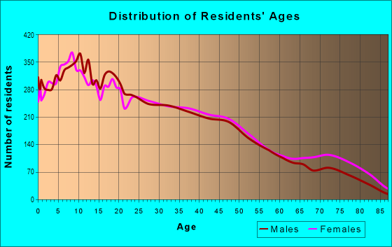
| Males: | 35,888 |
| Females: | 35,149 |
Males:
| This neighborhood: | 37.9 years |
| Whole city: | 35.5 years |
| This neighborhood: | 37.2 years |
| Whole city: | 37.7 years |
Average household size:
| Watson: | 5.4 people |
| Long Beach: | 2.6 people |
Percentage of family households:
| Watson: | 52.9% |
| Long Beach: | 43.1% |
| Here: | 50.8% |
| Long Beach: | 35.6% |
Percentage of married-couple families with children (among all households):
| Watson: | 16.7% |
| Long Beach: | 21.4% |
Percentage of single-mother households (among all households):
| Watson: | 10.4% |
| Long Beach: | 12.6% |
Percentage of never married males 15 years old and over:
Percentage of never married females 15 years old and over:
| Watson: | 25.3% |
| Long Beach: | 24.6% |
Percentage of never married females 15 years old and over:
| Watson: | 19.1% |
| city: | 23.9% |
Percentage of people that speak English not well or not at all:
| Watson: | 15.1% |
| Long Beach: | 7.4% |
Percentage of people born in this state:
Percentage of people born in another U.S. state:
Percentage of native residents but born outside the U.S.:
Percentage of foreign born residents:
| Here: | 52.1% |
| Long Beach: | 62.4% |
Percentage of people born in another U.S. state:
| Watson: | 5.1% |
| Long Beach: | 12.5% |
Percentage of native residents but born outside the U.S.:
| Here: | 1.4% |
| city: | 1.4% |
Percentage of foreign born residents:
| Here: | 41.4% |
| Long Beach: | 23.7% |

Owner-occupied
Renter-occupied


- Rooms in owner-occupied houses and condos in Watson
- 2661 room
- 1,3512 rooms
- 5583 rooms
- 2,3714 rooms
- 2,1985 rooms
- 4,0056 rooms
- 1,8387 rooms
- 1,7678 rooms
- 5479+ rooms

- Rooms in renter-occupied apartments in Watson
- 2,1111 room
- 1,6942 rooms
- 3,1883 rooms
- 4,3934 rooms
- 1,5005 rooms
- 1,2756 rooms
- 7247 rooms
- 1588 rooms
- 5439+ rooms
Owner-occupied
Renter-occupied

- Bedrooms in owner-occupied houses and condos in Watson
- 1,381no bedroom
- 6431 bedroom
- 2,5002 bedrooms
- 4,9603 bedrooms
- 2,8604 bedrooms
- 9765+ bedrooms

- Bedrooms in renter-occupied apartments in Watson
- 1,950no bedroom
- 4,1031 bedroom
- 4,5602 bedrooms
- 1,7463 bedrooms
- 5984 bedrooms
- 8415+ bedrooms
Average number of cars or other vehicles available in houses/condos:
Average number of cars or other vehicles available in apartments:
| This neighborhood: | |
| Long Beach: |
Average number of cars or other vehicles available in apartments:
| Here: | 1.5 |
| city: | 1.4 |
Percentage of units with a mortgage:
| Watson: | 64.4% |
| Long Beach: | 70.2% |
Average estimated value of detached houses in 2022 (61.8% of all units):
| Watson: | $586,323 |
| Long Beach: | $840,606 |

- Year house built in Watson
- 2,1722020 or later
- 5152010 to 2019
- 5812000 to 2009
- 8761990 to 1999
- 1,7471980 to 1989
- 2,8041970 to 1979
- 2,2571960 to 1969
- 4,4781950 to 1959
- 6,0281940 to 1949
- 2,7631939 or earlier

City-data.com crime index for city in 2020 (higher means more crime):
| City: | 312.7 |
| U.S. average: | 219.5 |
Travel time to work (commute)
![Travel time to work (commute)]()
- 251Less than 5 minutes
- 7475 to 9 minutes
- 2,48610 to 14 minutes
- 3,13415 to 19 minutes
- 3,35320 to 24 minutes
- 1,60925 to 29 minutes
- 3,89030 to 34 minutes
- 35935 to 39 minutes
- 69740 to 44 minutes
- 3,20545 to 59 minutes
- 1,23560 to 89 minutes
- 88290 or more minutes

Means of transportation to work
![Means of transportation to work]()
- 72.6%22,825Drove a car alone
- 12.0%3,779Carpooled
- 5.8%1,828Bus
- 3.8%1,208Subway or elevated rail
- 4.5%1,425Long-distance train or commuter rail
- 3.8%1,202Light rail, streetcar or trolley
- 2.9%901Taxi
- 7.9%2,489Motorcycle
- 4.2%1,313Bicycle
- 4.5%1,417Walked
- 4.6%1,462Other means
- 7.0%2,188Worked at home

Time leaving home to go to work
![Time leaving home to go to work]()
- 1,31212:00 a.m. to 4:59 a.m.
- 1,4125:00 a.m. to 5:29 a.m.
- 1,0825:30 a.m. to 5:59 a.m.
- 2,8356:00 a.m. to 6:29 a.m.
- 1,3066:30 a.m. to 6:59 a.m.
- 2,8067:00 a.m. to 7:29 a.m.
- 1,7537:30 a.m. to 7:59 a.m.
- 1,8118:00 a.m. to 8:29 a.m.
- 9928:30 a.m. to 8:59 a.m.
- 9989:00 a.m. to 9:59 a.m.
- 70910:00 a.m. to 10:59 a.m.
- 22111:00 a.m. to 11:59 a.m.
- 1,92012:00 p.m. to 3:59 p.m.
- 1,5434:00 p.m. to 11:59 p.m.

Occupations of males:
- Percentage of males in management occupations (except farmers):
Here: 6.7% city: 10.3%
- Percentage of males in business and financial operations occupations:
Here: 1.6% city: 5.1%
- Percentage of males in computer and mathematical occupations:
Here: 1.8% city: 4.1%
- Percentage of males in architecture and engineering occupations:
Here: 1.5% city: 3.2%
- Percentage of males in education, training, and library occupations:
Here: 2.8% city: 3.8%
- Percentage of males in arts, design, entertainment, sports, and media occupations:
Here: 1.3% city: 4.0%
- Percentage of males in healthcare practitioners and technical occupations:
Here: 2.2% city: 3.0%
- Percentage of males in service occupations:
Here: 17.9% city: 16.3%
- Percentage of males in sales and office occupations:
Here: 16.9% city: 15.7%
- Percentage of males in construction, extraction, and maintenance occupations:
Here: 12.6% city: 7.8%
- Percentage of males in production occupations:
Here: 11.2% city: 6.4%
- Percentage of males in transportation occupations:
Here: 10.0% city: 6.8%
- Percentage of males in material moving occupations:
Here: 7.7% city: 5.9%
Occupations of females:
- Percentage of females in management occupations (except farmers):
Here: 4.0% city: 9.5%
- Percentage of females in business and financial operations occupations:
Here: 2.8% city: 6.5%
- Percentage of females in computer and mathematical occupations:
Here: 3.3% city: 1.7%
- Percentage of females in life, physical, and social science occupations:
Here: 1.0% city: 1.0%
- Percentage of females in education, training, and library occupations:
Here: 6.1% city: 8.3%
- Percentage of females in arts, design, entertainment, sports, and media occupations:
Here: 1.7% city: 3.2%
- Percentage of females in healthcare practitioners and technical occupations:
Here: 8.9% city: 7.4%
- Percentage of females in service occupations:
Here: 24.5% city: 21.6%
- Percentage of females in sales and office occupations:
Here: 30.4% city: 27.8%
- Percentage of females in production occupations:
Here: 8.7% city: 3.0%
- Percentage of females in material moving occupations:
Here: 5.8% city: 2.5%
Education in this neighborhood (subdivision or community):
- Percentage of people 3 years and older in K-12 schools:
Watson: 24.1% Long Beach: 15.8%
- Percentage of people 3 years and older in undergraduate colleges:
Watson: 6.5% Long Beach: 7.2%
- Percentage of people 3 years and older in grad. or professional schools:
Watson: 2.1% Long Beach: 1.4%
- Percentage of students K-12 enrolled in private schools:
Watson: 39.7% Long Beach: 4.5%
Percentage of population below poverty level:
| Watson: | 13.0% |
| Long Beach: | 13.8% |
Percentage of married-couple families with both working:
| Watson: | 70.3% |
| Long Beach: | 68.2% |

- 55.2%Utility gas
- 23.2%Electricity
- 9.6%No fuel used
- 3.3%Wood
- 2.6%Bottled, tank, or LP gas
- 2.6%Fuel oil, kerosene, etc.
- 2.2%Solar energy
- 1.2%Other fuel
Limited-access highways (interstate or state) in this neighborhood:
I- 405 (San Diego Fwy)
Length: 4.15 miles
Direction: E-W
Direction: E-W
Long Beach Fwy (I- 710)
Length: 2.75 miles
Direction: N-S
Direction: N-S
Highways in this neighborhood:
State Rte 1 (Pacific Coast Hwy)
Length: 2.49 miles
Directions: E-W, SE-NW
Address range: 100 to 2999
Directions: E-W, SE-NW
Address range: 100 to 2999
State Rte 47 (Alameda St)
Length: 2.48 miles
Directions: N-S, SW-NE
Address range: 1301 to 24999
Directions: N-S, SW-NE
Address range: 1301 to 24999
State Rte 47 (S Alameda St)
Length: 1.79 miles
Directions: N-S, SW-NE
Address range: 22200 to 23899
Directions: N-S, SW-NE
Address range: 22200 to 23899
W Pacific Coast Hwy (State Rte 1)
Length: 1.61 miles
Directions: E-W, SE-NW
Address range: 1100 to 2599
Directions: E-W, SE-NW
Address range: 1100 to 2599
State Rte 103 (Terminal Island Fwy)
Length: 1.05 miles
Directions: N-S, SW-NE
Directions: N-S, SW-NE
Roads and streets:
E Sepulveda Blvd
Length: 3.48 miles
Directions: E-W, SE-NW
Address range: 994 to 2499
Directions: E-W, SE-NW
Address range: 994 to 2499
Santa Fe Ave
Length: 2.50 miles
Direction: N-S
Address range: 1800 to 22199
Direction: N-S
Address range: 1800 to 22199
Delta Ave
Length: 2.26 miles
Directions: N-S, SW-NE
Address range: 2000 to 3799
Directions: N-S, SW-NE
Address range: 2000 to 3799
Wilmington Ave
Length: 2.26 miles
Directions: N-S, SW-NE
Address range: 22100 to 24999
Directions: N-S, SW-NE
Address range: 22100 to 24999
Fashion Ave
Length: 2.20 miles
Directions: E-W, N-S, SW-NE
Address range: 1800 to 3799
Directions: E-W, N-S, SW-NE
Address range: 1800 to 3799
Caspian Ave
Length: 2.16 miles
Direction: N-S
Address range: 1800 to 3699
Direction: N-S
Address range: 1800 to 3699
Easy Ave
Length: 2.08 miles
Directions: N-S, SW-NE
Address range: 2000 to 3799
Directions: N-S, SW-NE
Address range: 2000 to 3799
Gale Ave
Length: 1.93 miles
Directions: E-W, N-S, SE-NW, SW-NE
Address range: 1900 to 3799
Directions: E-W, N-S, SE-NW, SW-NE
Address range: 1900 to 3799
Baltic Ave
Length: 1.84 miles
Direction: N-S
Address range: 2000 to 3699
Direction: N-S
Address range: 2000 to 3699
Adriatic Ave
Length: 1.84 miles
Directions: E-W, N-S, SW-NE
Address range: 2000 to 3599
Directions: E-W, N-S, SW-NE
Address range: 2000 to 3599
E Lomita Blvd
Length: 1.78 miles
Directions: E-W, N-S, SE-NW, SW-NE
Address range: 600 to 2099
Directions: E-W, N-S, SE-NW, SW-NE
Address range: 600 to 2099
W Wardlow Rd
Length: 1.35 miles
Directions: E-W, SE-NW
Address range: 990 to 2499
Directions: E-W, SE-NW
Address range: 990 to 2499
W 20th St
Length: 1.32 miles
Directions: E-W, N-S, SE-NW, SW-NE
Address range: 1200 to 2299
Directions: E-W, N-S, SE-NW, SW-NE
Address range: 1200 to 2299
E 223rd St
Length: 1.29 miles
Directions: E-W, N-S
Address range: 1751 to 2999
Directions: E-W, N-S
Address range: 1751 to 2999
W Hill St
Length: 1.22 miles
Direction: E-W
Address range: 1200 to 3299
Direction: E-W
Address range: 1200 to 3299
E Sandison St
Length: 1.13 miles
Directions: E-W, N-S
Address range: 300 to 1699
Directions: E-W, N-S
Address range: 300 to 1699
W Willow St
Length: 1.10 miles
Direction: E-W
Address range: 1200 to 2399
Direction: E-W
Address range: 1200 to 2399
Webster Ave
Length: 1.06 miles
Directions: N-S, SE-NW
Address range: 2200 to 3699
Directions: N-S, SE-NW
Address range: 2200 to 3699
Middle Rd
Length: 1.01 miles
Directions: E-W, N-S, SE-NW, SW-NE
Directions: E-W, N-S, SE-NW, SW-NE
W Spring St
Length: 0.97 miles
Direction: E-W
Address range: 1200 to 2199
Direction: E-W
Address range: 1200 to 2199
W Cameron St
Length: 0.96 miles
Directions: E-W, SE-NW
Address range: 1200 to 2497
Directions: E-W, SE-NW
Address range: 1200 to 2497
W 19th St
Length: 0.96 miles
Directions: E-W, SW-NE
Address range: 1200 to 2399
Directions: E-W, SW-NE
Address range: 1200 to 2399
E O St
Length: 0.93 miles
Direction: E-W
Address range: 200 to 1999
Direction: E-W
Address range: 200 to 1999
Seabright Ave
Length: 0.92 miles
Direction: N-S
Address range: 2100 to 3699
Direction: N-S
Address range: 2100 to 3699
W Arlington St
Length: 0.91 miles
Direction: E-W
Address range: 1400 to 2499
Direction: E-W
Address range: 1400 to 2499
W 23rd St
Length: 0.87 miles
Direction: E-W
Address range: 1200 to 2099
Direction: E-W
Address range: 1200 to 2099
W Burnett St
Length: 0.86 miles
Direction: E-W
Address range: 1200 to 2099
Direction: E-W
Address range: 1200 to 2099
Canal Ave
Length: 0.83 miles
Direction: N-S
Address range: 1800 to 2999
Direction: N-S
Address range: 1800 to 2999
W 25th St
Length: 0.81 miles
Direction: E-W
Address range: 1200 to 2099
Direction: E-W
Address range: 1200 to 2099
E Q St
Length: 0.79 miles
Direction: E-W
Address range: 100 to 1899
Direction: E-W
Address range: 100 to 1899
E Colon St
Length: 0.77 miles
Direction: E-W
Address range: 900 to 1899
Direction: E-W
Address range: 900 to 1899
N Springdale Dr
Length: 0.76 miles
Directions: E-W, N-S, SE-NW, SW-NE
Address range: 3000 to 3299
Directions: E-W, N-S, SE-NW, SW-NE
Address range: 3000 to 3299
W 32nd St
Length: 0.75 miles
Direction: E-W
Address range: 1200 to 2099
Direction: E-W
Address range: 1200 to 2099
W 34th St
Length: 0.74 miles
Direction: E-W
Address range: 1200 to 1899
Direction: E-W
Address range: 1200 to 1899
W 29th St
Length: 0.71 miles
Direction: E-W
Address range: 1200 to 2199
Direction: E-W
Address range: 1200 to 2199
W Lincoln St
Length: 0.70 miles
Direction: E-W
Address range: 1500 to 2499
Direction: E-W
Address range: 1500 to 2499
N Gold Star Dr
Length: 0.70 miles
Directions: E-W, N-S, SE-NW, SW-NE
Address range: 3000 to 3099
Directions: E-W, N-S, SE-NW, SW-NE
Address range: 3000 to 3099
Cota Ave
Length: 0.70 miles
Directions: E-W, N-S, SE-NW, SW-NE
Address range: 1800 to 2599
Directions: E-W, N-S, SE-NW, SW-NE
Address range: 1800 to 2599
W 21st St
Length: 0.67 miles
Direction: E-W
Address range: 1100 to 1840
Direction: E-W
Address range: 1100 to 1840
Blinn Ave
Length: 0.62 miles
Direction: N-S
Address range: 1300 to 1999
Direction: N-S
Address range: 1300 to 1999
E Cruces St
Length: 0.62 miles
Direction: E-W
Address range: 900 to 1699
Direction: E-W
Address range: 900 to 1699
Pacific Dr
Length: 0.61 miles
Directions: E-W, N-S, SE-NW, SW-NE
Address range: 1 to 199
Directions: E-W, N-S, SE-NW, SW-NE
Address range: 1 to 199
W Canton St
Length: 0.59 miles
Direction: E-W
Address range: 1400 to 2199
Direction: E-W
Address range: 1400 to 2199
Eubank Ave
Length: 0.56 miles
Direction: N-S
Address range: 1379 to 1799
Direction: N-S
Address range: 1379 to 1799
W 33rd St
Length: 0.56 miles
Direction: E-W
Address range: 1200 to 1699
Direction: E-W
Address range: 1200 to 1699
W 28th St
Length: 0.56 miles
Direction: E-W
Address range: 1200 to 1799
Direction: E-W
Address range: 1200 to 1799
N Avalon Blvd
Length: 0.55 miles
Direction: N-S
Address range: 1400 to 1799
Direction: N-S
Address range: 1400 to 1799
West Rd
Length: 0.55 miles
Directions: E-W, N-S
Directions: E-W, N-S
East Rd
Length: 0.54 miles
Directions: E-W, N-S, SW-NE
Directions: E-W, N-S, SW-NE
W Willard St
Length: 0.53 miles
Direction: E-W
Address range: 1700 to 2399
Direction: E-W
Address range: 1700 to 2399
W 27th St
Length: 0.53 miles
Directions: E-W, N-S, SW-NE
Address range: 1200 to 1799
Directions: E-W, N-S, SW-NE
Address range: 1200 to 1799
Hayes Ave
Length: 0.53 miles
Direction: N-S
Address range: 2300 to 2799
Direction: N-S
Address range: 2300 to 2799
N Banning Blvd
Length: 0.50 miles
Direction: N-S
Address range: 1400 to 1799
Direction: N-S
Address range: 1400 to 1799
Lakme Ave
Length: 0.49 miles
Direction: N-S
Address range: 1400 to 1799
Direction: N-S
Address range: 1400 to 1799
W 31st St
Length: 0.49 miles
Direction: E-W
Address range: 1200 to 1699
Direction: E-W
Address range: 1200 to 1699
W Parade St
Length: 0.45 miles
Direction: E-W
Address range: 1300 to 1699
Direction: E-W
Address range: 1300 to 1699
W Summit St
Length: 0.45 miles
Direction: E-W
Address range: 1300 to 1699
Direction: E-W
Address range: 1300 to 1699
River Ave
Length: 0.40 miles
Direction: N-S
Address range: 1800 to 3699
Direction: N-S
Address range: 1800 to 3699
Drumm Ave
Length: 0.40 miles
Direction: SW-NE
Address range: 1301 to 1599
Direction: SW-NE
Address range: 1301 to 1599
W Columbia St
Length: 0.40 miles
Direction: E-W
Address range: 1700 to 2199
Direction: E-W
Address range: 1700 to 2199
E 221st Pl
Length: 0.38 miles
Directions: E-W, N-S, SE-NW
Address range: 2600 to 2899
Directions: E-W, N-S, SE-NW
Address range: 2600 to 2899
W Williams St
Length: 0.37 miles
Directions: E-W, N-S, SW-NE
Address range: 2000 to 2299
Directions: E-W, N-S, SW-NE
Address range: 2000 to 2299
Harbor St
Length: 0.36 miles
Directions: N-S, SW-NE
Address range: 100 to 299
Directions: N-S, SW-NE
Address range: 100 to 299
W Constitution Ln
Length: 0.35 miles
Direction: E-W
Address range: 1900 to 2399
Direction: E-W
Address range: 1900 to 2399
San Gabriel Ave
Length: 0.33 miles
Directions: N-S, SW-NE
Address range: 1900 to 2099
Directions: N-S, SW-NE
Address range: 1900 to 2099
Denver Ave
Length: 0.32 miles
Direction: N-S
Address range: 3400 to 3699
Direction: N-S
Address range: 3400 to 3699
Broad Ave
Length: 0.32 miles
Direction: N-S
Address range: 1400 to 1799
Direction: N-S
Address range: 1400 to 1799
E R St
Length: 0.30 miles
Direction: E-W
Address range: 100 to 499
Direction: E-W
Address range: 100 to 499
W Jeanette Pl
Length: 0.27 miles
Direction: E-W
Address range: 1800 to 2099
Direction: E-W
Address range: 1800 to 2099
Beach St
Length: 0.27 miles
Directions: N-S, SE-NW, SW-NE
Address range: 100 to 399
Directions: N-S, SE-NW, SW-NE
Address range: 100 to 399
Harbor Ave
Length: 0.25 miles
Direction: N-S
Address range: 1800 to 1999
Direction: N-S
Address range: 1800 to 1999
Baker St
Length: 0.24 miles
Direction: E-W
Address range: 1200 to 1399
Direction: E-W
Address range: 1200 to 1399
Taper St
Length: 0.24 miles
Direction: E-W
Address range: 1200 to 1399
Direction: E-W
Address range: 1200 to 1399
Watson Ave
Length: 0.23 miles
Direction: N-S
Address range: 1300 to 1499
Direction: N-S
Address range: 1300 to 1499
Baypoint Ave
Length: 0.23 miles
Direction: N-S
Address range: 1400 to 1699
Direction: N-S
Address range: 1400 to 1699
N la Vere Dr
Length: 0.23 miles
Directions: E-W, N-S, SE-NW, SW-NE
Address range: 2600 to 2699
Directions: E-W, N-S, SE-NW, SW-NE
Address range: 2600 to 2699
N Regway Ave
Length: 0.22 miles
Direction: N-S
Address range: 2600 to 2799
Direction: N-S
Address range: 2600 to 2799
Sanford Ave
Length: 0.22 miles
Direction: N-S
Address range: 1300 to 1499
Direction: N-S
Address range: 1300 to 1499
Coral St
Length: 0.21 miles
Directions: N-S, SE-NW, SW-NE
Address range: 260 to 299
Directions: N-S, SE-NW, SW-NE
Address range: 260 to 299
Technology Pl
Length: 0.21 miles
Directions: E-W, N-S, SE-NW
Address range: 2124 to 2149
Directions: E-W, N-S, SE-NW
Address range: 2124 to 2149
Dolphin Dr
Length: 0.21 miles
Directions: E-W, SE-NW
Address range: 1 to 99
Directions: E-W, SE-NW
Address range: 1 to 99
Sunset Dr
Length: 0.20 miles
Directions: E-W, SE-NW
Address range: 1 to 399
Directions: E-W, SE-NW
Address range: 1 to 399
W Wilma Pl
Length: 0.20 miles
Direction: E-W
Address range: 1800 to 2099
Direction: E-W
Address range: 1800 to 2099
Coil Ave
Length: 0.19 miles
Direction: SW-NE
Direction: SW-NE
Winward Dr
Length: 0.19 miles
Directions: E-W, SE-NW, SW-NE
Address range: 1 to 299
Directions: E-W, SE-NW, SW-NE
Address range: 1 to 299
Merrimac Ave
Length: 0.19 miles
Directions: N-S, SW-NE
Address range: 2048 to 2199
Directions: N-S, SW-NE
Address range: 2048 to 2199
Hesperian Ave
Length: 0.19 miles
Direction: N-S
Address range: 3600 to 3699
Direction: N-S
Address range: 3600 to 3699
Monitor Ave
Length: 0.19 miles
Direction: N-S
Address range: 2044 to 2199
Direction: N-S
Address range: 2044 to 2199
1st St
Length: 0.18 miles
Directions: E-W, SE-NW
Directions: E-W, SE-NW
Netherly Ave
Length: 0.17 miles
Direction: N-S
Address range: 3200 to 3399
Direction: N-S
Address range: 3200 to 3399
Hobson Ave
Length: 0.17 miles
Direction: N-S
Address range: 1900 to 2099
Direction: N-S
Address range: 1900 to 2099
E Proctor St
Length: 0.16 miles
Direction: E-W
Address range: 400 to 599
Direction: E-W
Address range: 400 to 599
E Dolores St
Length: 0.16 miles
Direction: E-W
Address range: 400 to 599
Direction: E-W
Address range: 400 to 599
2nd St
Length: 0.15 miles
Direction: E-W
Direction: E-W
Gamble Ave
Length: 0.15 miles
Direction: N-S
Address range: 1400 to 1599
Direction: N-S
Address range: 1400 to 1599
3rd St
Length: 0.14 miles
Directions: E-W, SE-NW
Directions: E-W, SE-NW
Wise Ave
Length: 0.13 miles
Directions: N-S, SW-NE
Address range: 3500 to 3599
Directions: N-S, SW-NE
Address range: 3500 to 3599
Aquarius St
Length: 0.12 miles
Direction: E-W
Address range: 1700 to 1899
Direction: E-W
Address range: 1700 to 1899
E Don St
Length: 0.12 miles
Direction: E-W
Address range: 100 to 199
Direction: E-W
Address range: 100 to 199
E Chandler St
Length: 0.12 miles
Direction: E-W
Address range: 100 to 199
Direction: E-W
Address range: 100 to 199
Warnock Way
Length: 0.11 miles
Direction: E-W
Address range: 3000 to 3099
Direction: E-W
Address range: 3000 to 3099
S McHelen Ave
Length: 0.11 miles
Direction: N-S
Address range: 3700 to 22299
Direction: N-S
Address range: 3700 to 22299
Rodloy Ave
Length: 0.10 miles
Directions: N-S, SE-NW
Address range: 2600 to 2799
Directions: N-S, SE-NW
Address range: 2600 to 2799
W Carolyn Pl
Length: 0.09 miles
Directions: E-W, SW-NE
Address range: 2000 to 2099
Directions: E-W, SW-NE
Address range: 2000 to 2099
Park Rd
Length: 0.09 miles
Direction: E-W
Address range: 1700 to 1899
Direction: E-W
Address range: 1700 to 1899
Seagrove Ave
Length: 0.08 miles
Direction: N-S
Address range: 1400 to 1699
Direction: N-S
Address range: 1400 to 1699
Deepwater Ave
Length: 0.08 miles
Direction: N-S
Address range: 1400 to 1699
Direction: N-S
Address range: 1400 to 1699
W Webster Ave
Length: 0.08 miles
Directions: E-W, N-S, SE-NW
Address range: 1900 to 1999
Directions: E-W, N-S, SE-NW
Address range: 1900 to 1999
E N St
Length: 0.08 miles
Direction: E-W
Address range: 600 to 699
Direction: E-W
Address range: 600 to 699
W 32nd Trl
Length: 0.08 miles
Direction: E-W
Address range: 1400 to 1499
Direction: E-W
Address range: 1400 to 1499
W 26th Way
Length: 0.08 miles
Direction: E-W
Address range: 1400 to 1499
Direction: E-W
Address range: 1400 to 1499
Gemini St
Length: 0.07 miles
Direction: E-W
Address range: 1900 to 1999
Direction: E-W
Address range: 1900 to 1999
N Wetherly Ave
Length: 0.07 miles
Direction: N-S
Address range: 2722 to 2784
Direction: N-S
Address range: 2722 to 2784
Palm
Length: 0.07 miles
Direction: SE-NW
Address range: 1 to 199
Direction: SE-NW
Address range: 1 to 199
Sloop St
Length: 0.07 miles
Directions: E-W, SE-NW, SW-NE
Address range: 1 to 99
Directions: E-W, SE-NW, SW-NE
Address range: 1 to 99
W Maddox St
Length: 0.07 miles
Directions: E-W, SE-NW
Address range: 1200 to 1299
Directions: E-W, SE-NW
Address range: 1200 to 1299
W 32nd Way
Length: 0.06 miles
Direction: E-W
Address range: 1700 to 1799
Direction: E-W
Address range: 1700 to 1799
Terminal Island Fwy Rmp (W San Gabriel Ave)
Length: 0.06 miles
Direction: SE-NW
Address range: 1800 to 1811
Direction: SE-NW
Address range: 1800 to 1811
Gold Star Dr
Length: 0.06 miles
Direction: E-W
Direction: E-W
Schooner
Length: 0.06 miles
Direction: SE-NW
Address range: 1 to 199
Direction: SE-NW
Address range: 1 to 199
W Woodland Rd
Length: 0.06 miles
Direction: E-W
Address range: 1700 to 1799
Direction: E-W
Address range: 1700 to 1799
Pioneer Ave
Length: 0.05 miles
Direction: N-S
Address range: 1300 to 1399
Direction: N-S
Address range: 1300 to 1399
Mahar Ave
Length: 0.05 miles
Direction: N-S
Address range: 1300 to 1399
Direction: N-S
Address range: 1300 to 1399
Hyatt Ave
Length: 0.05 miles
Direction: N-S
Address range: 1377 to 1399
Direction: N-S
Address range: 1377 to 1399
S Salmon Ave
Length: 0.04 miles
Direction: N-S
Address range: 22200 to 22299
Direction: N-S
Address range: 22200 to 22299
Springdale Dr
Length: 0.03 miles
Directions: E-W, SW-NE
Address range: 3200 to 3299
Directions: E-W, SW-NE
Address range: 3200 to 3299
Yawl St
Length: 0.02 miles
Direction: SW-NE
Address range: 1 to 99
Direction: SW-NE
Address range: 1 to 99
Railroad features:
Union Pacific RR
Length: 7.99 miles
Directions: N-S, SE-NW, SW-NE
Directions: N-S, SE-NW, SW-NE
Southern Pacific RR
Length: 5.68 miles
Directions: E-W, N-S, SE-NW, SW-NE
Directions: E-W, N-S, SE-NW, SW-NE
at and Sf Rlwy
Length: 0.76 miles
Directions: E-W, N-S, SE-NW
Directions: E-W, N-S, SE-NW