Wayside (Lawndale) neighborhood in Houston, Texas (TX), 77011, 77023 detailed profile
Settings
X


Business Search - 14 Million verified businesses
Area: 2.990 square miles
Population: 13,099
Population density:
| Wayside (Lawndale): | 4,381 people per square mile |
| Houston: | 3,977 people per square mile |

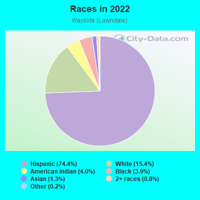
- 10,51374.4%Hispanic or Latino
- 2,17215.4%White
- 5704.0%American Indian
- 5483.9%Black
- 1811.3%Asian
- 1180.8%Two or more races
- 280.2%Some other race
Distribution of median household income
![Distribution of median household income]()
- 480Less than $10,000
- 447$10,000 to $19,999
- 705$20,000 to $29,999
- 795$30,000 to $39,999
- 729$40,000 to $49,999
- 355$50,000 to $59,999
- 531$60,000 to $74,999
- 620$75,000 to $99,999
- 327$100,000 to $124,999
- 319$125,000 to $149,999
- 554$150,000 to $199,999
- 377$200,000 or more

Distribution of owner-occupied house/condo value
![Distribution of owner-occupied house/condo value]()
- 1,267Less than $50,000
- 872$50,000 to $99,999
- 471$100,000 to $149,999
- 990$150,000 to $199,999
- 244$200,000 to $249,999
- 265$250,000 to $299,999
- 708$300,000 to $399,999
- 658$400,000 to $499,999
- 221$500,000 to $749,999
- 66$750,000 to $999,999
- 93$1,000,000 or more

Distribution of rent paid by renters
![Distribution of rent paid by renters]()
- 333$100 to $199
- 114$200 to $299
- 221$300 to $399
- 615$400 to $499
- 504$500 to $599
- 420$600 to $699
- 635$700 to $799
- 501$800 to $899
- 412$900 to $999
- 682$1,000 to $1,249
- 418$1,250 to $1,499
- 151$1,500 to $1,999
- 202$2,000 or more

Median rent in 2022:
| Wayside (Lawndale): | $860 |
| Houston: | $1,089 |
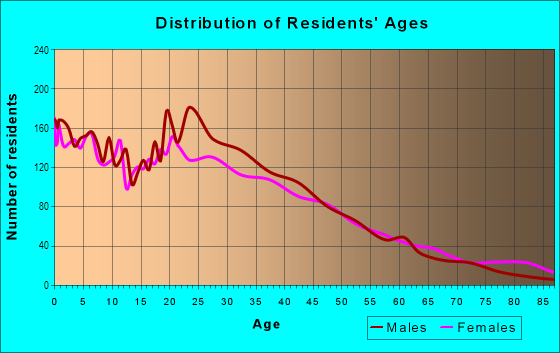
| Males: | 6,596 |
| Females: | 6,503 |
Males:
| This neighborhood: | 37.2 years |
| Whole city: | 34.4 years |
| This neighborhood: | 38.3 years |
| Whole city: | 34.7 years |
Average household size:
| Wayside (Lawndale): | 2.7 people |
| Houston: | 2.4 people |
Percentage of family households:
| Wayside (Lawndale): | 49.1% |
| Houston: | 43.0% |
| Here: | 41.4% |
| Houston: | 34.7% |
Percentage of married-couple families with children (among all households):
| Wayside (Lawndale): | 20.8% |
| Houston: | 23.3% |
Percentage of single-mother households (among all households):
| Wayside (Lawndale): | 12.1% |
| Houston: | 13.9% |
Percentage of never married males 15 years old and over:
Percentage of never married females 15 years old and over:
| Wayside (Lawndale): | 18.5% |
| Houston: | 22.9% |
Percentage of never married females 15 years old and over:
| Wayside (Lawndale): | 19.7% |
| city: | 21.2% |
Percentage of people that speak English not well or not at all:
| Wayside (Lawndale): | 22.1% |
| Houston: | 15.9% |
Percentage of people born in this state:
Percentage of people born in another U.S. state:
Percentage of native residents but born outside the U.S.:
Percentage of foreign born residents:
| Here: | 67.9% |
| Houston: | 51.1% |
Percentage of people born in another U.S. state:
| Wayside (Lawndale): | 6.9% |
| Houston: | 17.7% |
Percentage of native residents but born outside the U.S.:
| Here: | 2.2% |
| city: | 1.8% |
Percentage of foreign born residents:
| Here: | 23.9% |
| Houston: | 29.4% |
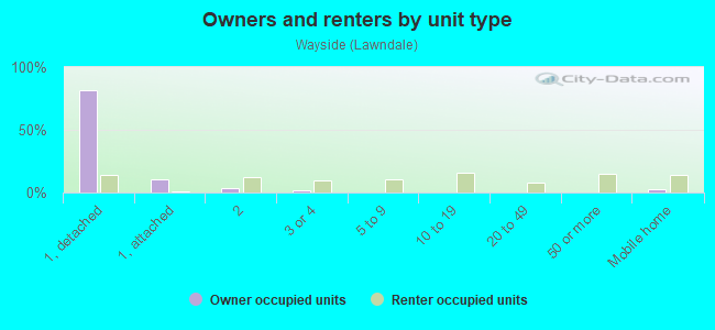
Owner-occupied
Renter-occupied

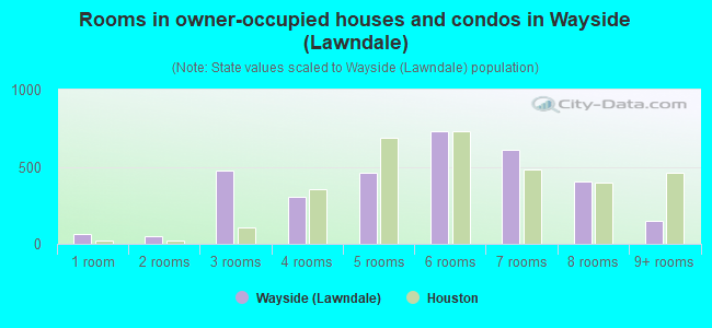
- Rooms in owner-occupied houses and condos in Wayside <
> - 651 room
- 532 rooms
- 4773 rooms
- 3084 rooms
- 4595 rooms
- 7286 rooms
- 6127 rooms
- 4048 rooms
- 1469+ rooms
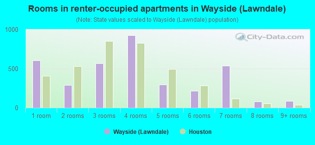
- Rooms in renter-occupied apartments in Wayside <
> - 6081 room
- 2932 rooms
- 5693 rooms
- 9234 rooms
- 2985 rooms
- 2186 rooms
- 5397 rooms
- 788 rooms
- 869+ rooms
Owner-occupied
Renter-occupied
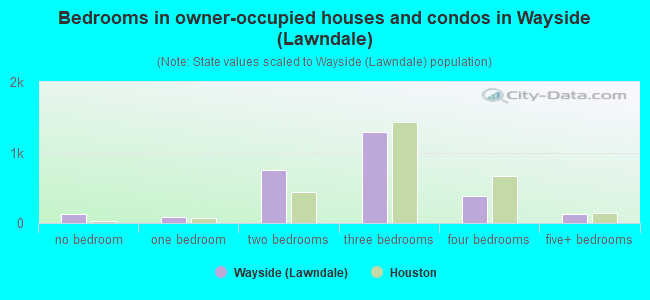
- Bedrooms in owner-occupied houses and condos in Wayside <
> - 121no bedroom
- 801 bedroom
- 7552 bedrooms
- 1,2923 bedrooms
- 3834 bedrooms
- 1315+ bedrooms
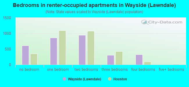
- Bedrooms in renter-occupied apartments in Wayside <
> - 608no bedroom
- 8601 bedroom
- 9412 bedrooms
- 3093 bedrooms
- 3244 bedrooms
- 05+ bedrooms
Average number of cars or other vehicles available in houses/condos:
Average number of cars or other vehicles available in apartments:
| This neighborhood: | 2.1 |
| Houston: | 2.0 |
Average number of cars or other vehicles available in apartments:
| Here: | 1.2 |
| city: | 1.3 |
Percentage of units with a mortgage:
| Wayside (Lawndale): | 39.3% |
| Houston: | 50.8% |
Average estimated value of detached houses in 2022 (58.8% of all units):
| Wayside (Lawndale): | $233,549 |
| Houston: | $368,067 |
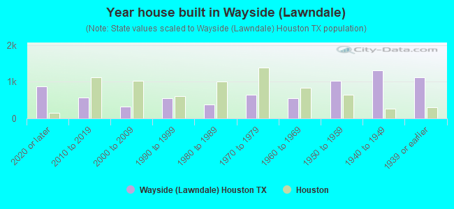
- Year house built in Wayside <
> - 8742020 or later
- 5732010 to 2019
- 3312000 to 2009
- 5501990 to 1999
- 3821980 to 1989
- 6541970 to 1979
- 5521960 to 1969
- 1,0311950 to 1959
- 1,3231940 to 1949
- 1,1201939 or earlier
City-data.com crime index for city in 2020 (higher means more crime):
| City: | 560.9 |
| U.S. average: | 219.5 |
Travel time to work (commute)
![Travel time to work (commute)]()
- 149Less than 5 minutes
- 4055 to 9 minutes
- 79410 to 14 minutes
- 1,11215 to 19 minutes
- 85920 to 24 minutes
- 52325 to 29 minutes
- 74930 to 34 minutes
- 19135 to 39 minutes
- 14840 to 44 minutes
- 41745 to 59 minutes
- 17660 to 89 minutes
- 10990 or more minutes

Means of transportation to work
![Means of transportation to work]()
- 75.2%4,519Drove a car alone
- 9.9%592Carpooled
- 5.3%318Bus
- 4.6%279Light rail, streetcar or trolley
- 7.8%467Bicycle
- 3.5%210Walked
- 8.9%535Other means
- 7.9%476Worked at home

Time leaving home to go to work
![Time leaving home to go to work]()
- 39412:00 a.m. to 4:59 a.m.
- 2025:00 a.m. to 5:29 a.m.
- 3085:30 a.m. to 5:59 a.m.
- 5716:00 a.m. to 6:29 a.m.
- 3976:30 a.m. to 6:59 a.m.
- 9987:00 a.m. to 7:29 a.m.
- 3697:30 a.m. to 7:59 a.m.
- 8228:00 a.m. to 8:29 a.m.
- 2028:30 a.m. to 8:59 a.m.
- 3839:00 a.m. to 9:59 a.m.
- 13510:00 a.m. to 10:59 a.m.
- 5011:00 a.m. to 11:59 a.m.
- 30012:00 p.m. to 3:59 p.m.
- 4754:00 p.m. to 11:59 p.m.

Occupations of males:
- Percentage of males in management occupations (except farmers):
Here: 10.5% city: 10.6%
- Percentage of males in business and financial operations occupations:
Here: 2.2% city: 5.4%
- Percentage of males in computer and mathematical occupations:
Here: 1.2% city: 3.9%
- Percentage of males in architecture and engineering occupations:
Here: 1.5% city: 4.0%
- Percentage of males in legal occupations:
Here: 1.1% city: 1.4%
- Percentage of males in education, training, and library occupations:
Here: 2.3% city: 3.1%
- Percentage of males in arts, design, entertainment, sports, and media occupations:
Here: 1.9% city: 1.6%
- Percentage of males in healthcare practitioners and technical occupations:
Here: 2.6% city: 2.7%
- Percentage of males in service occupations:
Here: 9.8% city: 12.9%
- Percentage of males in sales and office occupations:
Here: 10.9% city: 13.5%
- Percentage of males in construction, extraction, and maintenance occupations:
Here: 22.2% city: 15.7%
- Percentage of males in production occupations:
Here: 11.2% city: 6.0%
- Percentage of males in transportation occupations:
Here: 7.2% city: 6.1%
- Percentage of males in material moving occupations:
Here: 5.0% city: 5.4%
Occupations of females:
- Percentage of females in management occupations (except farmers):
Here: 7.0% city: 8.6%
- Percentage of females in business and financial operations occupations:
Here: 4.7% city: 6.8%
- Percentage of females in computer and mathematical occupations:
Here: 1.4% city: 1.7%
- Percentage of females in architecture and engineering occupations:
Here: 1.3% city: 1.4%
- Percentage of females in community and social services occupations:
Here: 3.8% city: 1.8%
- Percentage of females in legal occupations:
Here: 1.4% city: 2.0%
- Percentage of females in education, training, and library occupations:
Here: 4.8% city: 8.5%
- Percentage of females in arts, design, entertainment, sports, and media occupations:
Here: 1.5% city: 2.0%
- Percentage of females in healthcare practitioners and technical occupations:
Here: 5.1% city: 8.1%
- Percentage of females in service occupations:
Here: 29.1% city: 23.8%
- Percentage of females in sales and office occupations:
Here: 32.1% city: 26.6%
- Percentage of females in production occupations:
Here: 4.6% city: 2.6%
- Percentage of females in material moving occupations:
Here: 1.5% city: 2.5%
Percentage of people 16-64 in Armed Forces:
| Wayside (Lawndale): | 0.0% |
| Houston: | 0.1% |
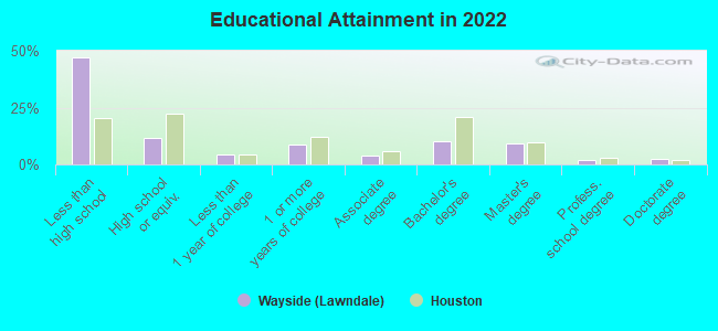
Education in this neighborhood (subdivision or community):
- Percentage of people 3 years and older in K-12 schools:
Wayside (Lawndale): 26.7% Houston: 16.6%
- Percentage of people 3 years and older in undergraduate colleges:
Wayside (Lawndale): 5.8% Houston: 4.6%
- Percentage of people 3 years and older in grad. or professional schools:
Wayside (Lawndale): 2.7% Houston: 1.6%
- Percentage of students K-12 enrolled in private schools:
Wayside (Lawndale): 47.1% Houston: 9.0%
Percentage of population below poverty level:
| Wayside (Lawndale): | 19.1% |
| Houston: | 20.7% |
Percentage of married-couple families with both working:
| Wayside (Lawndale): | 70.7% |
| Houston: | 54.9% |
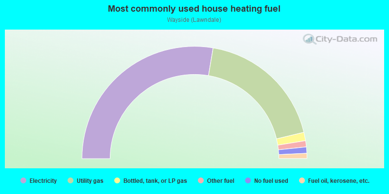
- 55.3%Electricity
- 37.2%Utility gas
- 2.4%Bottled, tank, or LP gas
- 1.8%Other fuel
- 1.8%No fuel used
- 1.5%Fuel oil, kerosene, etc.
Limited-access highways (interstate or state) in this neighborhood:
Gulf Fwy (I- 45)
Length: 2.78 miles
Direction: SE-NW
Direction: SE-NW
Highways in this neighborhood:
US Hwy 90 Alt (S Wayside Dr)
Length: 1.87 miles
Directions: N-S, SW-NE
Address range: 200 to 2399
Directions: N-S, SW-NE
Address range: 200 to 2399
Roads and streets:
Lawndale St
Length: 2.46 miles
Directions: E-W, SE-NW
Address range: 5250 to 7199
Directions: E-W, SE-NW
Address range: 5250 to 7199
Griggs Rd
Length: 1.15 miles
Direction: SW-NE
Address range: 6400 to 7199
Direction: SW-NE
Address range: 6400 to 7199
S 75th St
Length: 1.15 miles
Directions: N-S, SE-NW, SW-NE
Address range: 300 to 999
Directions: N-S, SE-NW, SW-NE
Address range: 300 to 999
Forest Hill Blvd
Length: 0.98 miles
Directions: E-W, N-S, SE-NW, SW-NE
Address range: 220 to 2099
Directions: E-W, N-S, SE-NW, SW-NE
Address range: 220 to 2099
Satsuma St
Length: 0.97 miles
Directions: E-W, SE-NW
Address range: 7100 to 7799
Directions: E-W, SE-NW
Address range: 7100 to 7799
Hackney St
Length: 0.87 miles
Directions: E-W, N-S, SW-NE
Address range: 900 to 2114
Directions: E-W, N-S, SW-NE
Address range: 900 to 2114
Dismuke St
Length: 0.75 miles
Directions: N-S, SW-NE
Address range: 1100 to 2199
Directions: N-S, SW-NE
Address range: 1100 to 2199
Rusk St
Length: 0.73 miles
Directions: E-W, SE-NW
Address range: 6500 to 7499
Directions: E-W, SE-NW
Address range: 6500 to 7499
Pasadena St
Length: 0.70 miles
Directions: N-S, SE-NW, SW-NE
Address range: 1700 to 2099
Directions: N-S, SE-NW, SW-NE
Address range: 1700 to 2099
Tipps St
Length: 0.67 miles
Directions: E-W, SE-NW, SW-NE
Address range: 7301 to 7799
Directions: E-W, SE-NW, SW-NE
Address range: 7301 to 7799
Hughes St
Length: 0.65 miles
Directions: N-S, SW-NE
Address range: 214 to 1699
Directions: N-S, SW-NE
Address range: 214 to 1699
Magnolia St
Length: 0.64 miles
Direction: E-W
Address range: 7400 to 7799
Direction: E-W
Address range: 7400 to 7799
Sunnyland St
Length: 0.62 miles
Directions: N-S, SW-NE
Address range: 1200 to 2199
Directions: N-S, SW-NE
Address range: 1200 to 2199
Polk St
Length: 0.62 miles
Directions: E-W, SW-NE
Address range: 5301 to 6799
Directions: E-W, SW-NE
Address range: 5301 to 6799
Telephone Rd
Length: 0.62 miles
Direction: SE-NW
Address range: 1596 to 2499
Direction: SE-NW
Address range: 1596 to 2499
N Mac Gregor Way
Length: 0.61 miles
Directions: E-W, N-S, SE-NW, SW-NE
Address range: 1200 to 1999
Directions: E-W, N-S, SE-NW, SW-NE
Address range: 1200 to 1999
Jefferson St
Length: 0.60 miles
Directions: E-W, SE-NW
Address range: 5387 to 6499
Directions: E-W, SE-NW
Address range: 5387 to 6499
Alta Vista St
Length: 0.60 miles
Directions: N-S, SE-NW, SW-NE
Address range: 1700 to 2099
Directions: N-S, SE-NW, SW-NE
Address range: 1700 to 2099
Azalea St
Length: 0.59 miles
Direction: E-W
Address range: 7400 to 7799
Direction: E-W
Address range: 7400 to 7799
Des Jardines St
Length: 0.58 miles
Directions: E-W, N-S, SW-NE
Address range: 1200 to 1999
Directions: E-W, N-S, SW-NE
Address range: 1200 to 1999
Erath St
Length: 0.55 miles
Direction: E-W
Address range: 7400 to 7799
Direction: E-W
Address range: 7400 to 7799
Eskridge St
Length: 0.54 miles
Directions: E-W, SE-NW
Address range: 5500 to 5899
Directions: E-W, SE-NW
Address range: 5500 to 5899
Elm St
Length: 0.53 miles
Directions: E-W, SW-NE
Address range: 7400 to 7799
Directions: E-W, SW-NE
Address range: 7400 to 7799
Fair Oaks Rd
Length: 0.52 miles
Directions: E-W, N-S, SW-NE
Address range: 800 to 1199
Directions: E-W, N-S, SW-NE
Address range: 800 to 1199
Santa Rosa St
Length: 0.50 miles
Directions: E-W, N-S, SW-NE
Address range: 1800 to 2099
Directions: E-W, N-S, SW-NE
Address range: 1800 to 2099
Idylwood Dr
Length: 0.48 miles
Directions: N-S, SW-NE
Address range: 1200 to 1999
Directions: N-S, SW-NE
Address range: 1200 to 1999
Evergreen Dr
Length: 0.47 miles
Direction: N-S
Address range: 500 to 999
Direction: N-S
Address range: 500 to 999
Dallas St
Length: 0.46 miles
Direction: E-W
Address range: 7000 to 7499
Direction: E-W
Address range: 7000 to 7499
Santiago St
Length: 0.46 miles
Direction: E-W
Address range: 7000 to 7399
Direction: E-W
Address range: 7000 to 7399
Villa de Matel Rd
Length: 0.45 miles
Directions: E-W, N-S, SW-NE
Address range: 800 to 1199
Directions: E-W, N-S, SW-NE
Address range: 800 to 1199
Brookside Dr
Length: 0.41 miles
Directions: E-W, N-S, SE-NW, SW-NE
Address range: 6300 to 6599
Directions: E-W, N-S, SE-NW, SW-NE
Address range: 6300 to 6599
Rainbow Dr
Length: 0.41 miles
Directions: N-S, SE-NW
Address range: 219 to 2299
Directions: N-S, SE-NW
Address range: 219 to 2299
Sylvan Rd
Length: 0.40 miles
Directions: E-W, N-S, SE-NW
Address range: 6600 to 6799
Directions: E-W, N-S, SE-NW
Address range: 6600 to 6799
Supply Row
Length: 0.39 miles
Directions: E-W, SE-NW
Address range: 6500 to 6799
Directions: E-W, SE-NW
Address range: 6500 to 6799
Santa Maria St
Length: 0.37 miles
Directions: N-S, SE-NW, SW-NE
Address range: 6900 to 7099
Directions: N-S, SE-NW, SW-NE
Address range: 6900 to 7099
Barremore St
Length: 0.36 miles
Direction: E-W
Address range: 5400 to 5699
Direction: E-W
Address range: 5400 to 5699
Lawson St
Length: 0.36 miles
Direction: E-W
Address range: 5400 to 5699
Direction: E-W
Address range: 5400 to 5699
Wildwood Way
Length: 0.36 miles
Direction: E-W
Address range: 6600 to 6799
Direction: E-W
Address range: 6600 to 6799
Fairfield Dr (Fairfield St)
Length: 0.35 miles
Direction: E-W
Address range: 6600 to 6799
Direction: E-W
Address range: 6600 to 6799
Country Club Dr
Length: 0.34 miles
Directions: E-W, SE-NW
Address range: 6400 to 6599
Directions: E-W, SE-NW
Address range: 6400 to 6599
Meadowlawn St
Length: 0.34 miles
Directions: E-W, SE-NW
Address range: 6600 to 6799
Directions: E-W, SE-NW
Address range: 6600 to 6799
Redwood Ave (Redwood St)
Length: 0.34 miles
Directions: N-S, SE-NW, SW-NE
Address range: 800 to 1299
Directions: N-S, SE-NW, SW-NE
Address range: 800 to 1299
Esperanza St
Length: 0.34 miles
Directions: N-S, SE-NW, SW-NE
Address range: 1700 to 2099
Directions: N-S, SE-NW, SW-NE
Address range: 1700 to 2099
Pinehurst Dr (Pinehurst St)
Length: 0.34 miles
Direction: E-W
Address range: 6400 to 6599
Direction: E-W
Address range: 6400 to 6599
Dorbrandt St
Length: 0.33 miles
Direction: E-W
Address range: 5500 to 5799
Direction: E-W
Address range: 5500 to 5799
Walker St
Length: 0.33 miles
Directions: E-W, SE-NW
Address range: 7300 to 7499
Directions: E-W, SE-NW
Address range: 7300 to 7499
Smallwood Ln
Length: 0.33 miles
Directions: N-S, SW-NE
Address range: 1100 to 1599
Directions: N-S, SW-NE
Address range: 1100 to 1599
Newport St
Length: 0.33 miles
Direction: E-W
Address range: 5500 to 5799
Direction: E-W
Address range: 5500 to 5799
S 66th St
Length: 0.32 miles
Directions: N-S, SW-NE
Address range: 300 to 499
Directions: N-S, SW-NE
Address range: 300 to 499
Bonsrell St
Length: 0.32 miles
Direction: E-W
Address range: 5500 to 5699
Direction: E-W
Address range: 5500 to 5699
Truett St
Length: 0.32 miles
Direction: E-W
Address range: 5500 to 5699
Direction: E-W
Address range: 5500 to 5699
Mc Cormick St
Length: 0.32 miles
Direction: E-W
Address range: 5500 to 5699
Direction: E-W
Address range: 5500 to 5699
Hillman St
Length: 0.32 miles
Direction: E-W
Address range: 5500 to 5699
Direction: E-W
Address range: 5500 to 5699
Tellepsen St
Length: 0.31 miles
Directions: E-W, SW-NE
Address range: 1800 to 1999
Directions: E-W, SW-NE
Address range: 1800 to 1999
Munger St
Length: 0.30 miles
Directions: N-S, SE-NW, SW-NE
Address range: 2000 to 2299
Directions: N-S, SE-NW, SW-NE
Address range: 2000 to 2299
Park Ln
Length: 0.29 miles
Directions: E-W, SE-NW
Address range: 6600 to 6799
Directions: E-W, SE-NW
Address range: 6600 to 6799
Merry Ln
Length: 0.29 miles
Directions: E-W, SE-NW, SW-NE
Address range: 6600 to 6799
Directions: E-W, SE-NW, SW-NE
Address range: 6600 to 6799
Craig St
Length: 0.29 miles
Direction: E-W
Address range: 5500 to 5799
Direction: E-W
Address range: 5500 to 5799
Capitol St
Length: 0.28 miles
Direction: E-W
Address range: 6600 to 6799
Direction: E-W
Address range: 6600 to 6799
Maxwell Ln
Length: 0.28 miles
Directions: N-S, SW-NE
Address range: 2000 to 2399
Directions: N-S, SW-NE
Address range: 2000 to 2399
Harriet St
Length: 0.27 miles
Direction: E-W
Address range: 5600 to 5799
Direction: E-W
Address range: 5600 to 5799
Hatwell St
Length: 0.26 miles
Directions: N-S, SW-NE
Address range: 1800 to 2199
Directions: N-S, SW-NE
Address range: 1800 to 2199
Kolfahl St
Length: 0.25 miles
Directions: E-W, SW-NE
Address range: 1803 to 1999
Directions: E-W, SW-NE
Address range: 1803 to 1999
S 69th St
Length: 0.25 miles
Directions: N-S, SW-NE
Address range: 301 to 399
Directions: N-S, SW-NE
Address range: 301 to 399
Coral St
Length: 0.24 miles
Directions: N-S, SE-NW
Address range: 500 to 799
Directions: N-S, SE-NW
Address range: 500 to 799
S 72nd St
Length: 0.23 miles
Directions: N-S, SW-NE
Address range: 220 to 499
Directions: N-S, SW-NE
Address range: 220 to 499
Baldinger St
Length: 0.22 miles
Directions: N-S, SW-NE
Address range: 200 to 499
Directions: N-S, SW-NE
Address range: 200 to 499
Rockbridge Ln
Length: 0.21 miles
Directions: E-W, SE-NW
Address range: 6600 to 6699
Directions: E-W, SE-NW
Address range: 6600 to 6699
Jean St
Length: 0.21 miles
Directions: E-W, N-S, SW-NE
Address range: 1800 to 1999
Directions: E-W, N-S, SW-NE
Address range: 1800 to 1999
Lamar St
Length: 0.20 miles
Directions: E-W, SE-NW
Address range: 7300 to 7499
Directions: E-W, SE-NW
Address range: 7300 to 7499
Bell St
Length: 0.19 miles
Direction: E-W
Address range: 5422 to 5699
Direction: E-W
Address range: 5422 to 5699
Jamail Dr
Length: 0.19 miles
Direction: E-W
Address range: 6500 to 6599
Direction: E-W
Address range: 6500 to 6599
Leeland St
Length: 0.19 miles
Direction: E-W
Address range: 5400 to 5699
Direction: E-W
Address range: 5400 to 5699
S 67th St (S Cesar Chavez Blvd)
Length: 0.19 miles
Directions: N-S, SW-NE
Address range: 300 to 399
Directions: N-S, SW-NE
Address range: 300 to 399
Lindy Ln
Length: 0.19 miles
Direction: E-W
Address range: 6600 to 6699
Direction: E-W
Address range: 6600 to 6699
S 74th St
Length: 0.18 miles
Directions: N-S, SW-NE
Address range: 306 to 499
Directions: N-S, SW-NE
Address range: 306 to 499
Marlo St
Length: 0.18 miles
Direction: SE-NW
Address range: 2200 to 2299
Direction: SE-NW
Address range: 2200 to 2299
Clay St
Length: 0.17 miles
Direction: E-W
Address range: 5436 to 5699
Direction: E-W
Address range: 5436 to 5699
Jocelin St
Length: 0.16 miles
Direction: N-S
Address range: 1100 to 1199
Direction: N-S
Address range: 1100 to 1199
Matamoras St
Length: 0.15 miles
Direction: N-S
Address range: 1800 to 1899
Direction: N-S
Address range: 1800 to 1899
Miraglen St
Length: 0.15 miles
Direction: E-W
Address range: 6500 to 6599
Direction: E-W
Address range: 6500 to 6599
Harwell Dr
Length: 0.15 miles
Directions: N-S, SE-NW, SW-NE
Address range: 2200 to 2299
Directions: N-S, SE-NW, SW-NE
Address range: 2200 to 2299
Polk Ct
Length: 0.14 miles
Directions: E-W, SW-NE
Address range: 5700 to 5799
Directions: E-W, SW-NE
Address range: 5700 to 5799
Mc Cormick
Length: 0.14 miles
Direction: E-W
Direction: E-W
Mc Kinney St
Length: 0.13 miles
Directions: E-W, N-S, SE-NW
Address range: 7400 to 7499
Directions: E-W, N-S, SE-NW
Address range: 7400 to 7499
Kemp St
Length: 0.13 miles
Directions: E-W, N-S, SE-NW
Address range: 5600 to 5799
Directions: E-W, N-S, SE-NW
Address range: 5600 to 5799
Myrtle St
Length: 0.13 miles
Direction: SW-NE
Address range: 7111 to 7306
Direction: SW-NE
Address range: 7111 to 7306
Hub St
Length: 0.12 miles
Direction: N-S
Address range: 1100 to 1199
Direction: N-S
Address range: 1100 to 1199
Palo Alto St
Length: 0.12 miles
Directions: E-W, SE-NW, SW-NE
Address range: 2000 to 2099
Directions: E-W, SE-NW, SW-NE
Address range: 2000 to 2099
Herbert St
Length: 0.11 miles
Direction: E-W
Address range: 7000 to 7099
Direction: E-W
Address range: 7000 to 7099
Lawndale Plz
Length: 0.10 miles
Directions: E-W, N-S
Address range: 1500 to 1599
Directions: E-W, N-S
Address range: 1500 to 1599
Swope
Length: 0.10 miles
Directions: N-S, SW-NE
Address range: 1200 to 1399
Directions: N-S, SW-NE
Address range: 1200 to 1399
Kenmore St
Length: 0.10 miles
Direction: N-S
Address range: 900 to 999
Direction: N-S
Address range: 900 to 999
Lansing St
Length: 0.10 miles
Direction: N-S
Address range: 1500 to 1599
Direction: N-S
Address range: 1500 to 1599
Dwinnell St
Length: 0.09 miles
Direction: E-W
Address range: 5700 to 5799
Direction: E-W
Address range: 5700 to 5799
Pease St
Length: 0.08 miles
Direction: E-W
Address range: 5400 to 5499
Direction: E-W
Address range: 5400 to 5499
Manchester St
Length: 0.08 miles
Directions: E-W, N-S, SE-NW, SW-NE
Address range: 7100 to 7199
Directions: E-W, N-S, SE-NW, SW-NE
Address range: 7100 to 7199
Sibley St
Length: 0.08 miles
Direction: N-S
Address range: 1800 to 1899
Direction: N-S
Address range: 1800 to 1899
Telephone-Gulf Fwy
Length: 0.07 miles
Directions: E-W, N-S, SW-NE
Directions: E-W, N-S, SW-NE
Rosebud St
Length: 0.06 miles
Directions: N-S, SE-NW, SW-NE
Directions: N-S, SE-NW, SW-NE
S 77th St
Length: 0.06 miles
Direction: N-S
Address range: 800 to 899
Direction: N-S
Address range: 800 to 899
S 76th St
Length: 0.06 miles
Directions: N-S, SW-NE
Address range: 800 to 899
Directions: N-S, SW-NE
Address range: 800 to 899
Hughes
Length: 0.06 miles
Direction: SW-NE
Address range: 600 to 710
Direction: SW-NE
Address range: 600 to 710
Benjamin
Length: 0.05 miles
Direction: E-W
Address range: 7100 to 7199
Direction: E-W
Address range: 7100 to 7199
Magnolia
Length: 0.05 miles
Directions: E-W, SW-NE
Directions: E-W, SW-NE
Craigmont St
Length: 0.02 miles
Directions: N-S, SW-NE
Directions: N-S, SW-NE
S 65th St
Length: 0.02 miles
Direction: SW-NE
Address range: 268 to 299
Direction: SW-NE
Address range: 268 to 299
Railroad features:
Union Pacific RR
Length: 2.52 miles
Directions: E-W, N-S, SE-NW
Directions: E-W, N-S, SE-NW
Houston Belt and Terminal Rlwy
Length: 1.39 miles
Direction: SW-NE
Direction: SW-NE
Southern Pacific RR
Length: 1.27 miles
Directions: E-W, SE-NW, SW-NE
Directions: E-W, SE-NW, SW-NE
Other features:
Brays Byu
Length: 2.23 miles
Directions: E-W, N-S, SE-NW, SW-NE
Directions: E-W, N-S, SE-NW, SW-NE
Country Club Byu
Length: 1.34 miles
Directions: E-W, N-S, SE-NW, SW-NE
Directions: E-W, N-S, SE-NW, SW-NE