West 7th-Fort Road neighborhood in Saint Paul, Minnesota (MN), 55102, 55116 detailed profile
Settings
X


Area: 2.777 square miles
Population: 11,227
Population density: 4,043 people per square mile

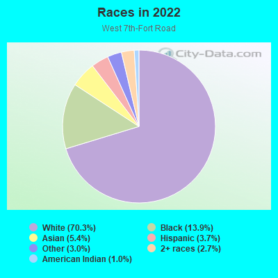
- 8,47270.3%White
- 1,67613.9%Black
- 6545.4%Asian
- 4503.7%Hispanic or Latino
- 3643.0%Some other race
- 3212.7%Two or more races
- 1181.0%American Indian
Median household income in 2022:
| West 7th-Fort Road: | $97,472 |
| Minnesota: | $82,338 |
Distribution of median household income
![Distribution of median household income]()
- 479Less than $10,000
- 693$10,000 to $19,999
- 799$20,000 to $29,999
- 497$30,000 to $39,999
- 742$40,000 to $49,999
- 403$50,000 to $59,999
- 505$60,000 to $74,999
- 853$75,000 to $99,999
- 592$100,000 to $124,999
- 364$125,000 to $149,999
- 439$150,000 to $199,999
- 369$200,000 or more

Distribution of owner-occupied house/condo value
![Distribution of owner-occupied house/condo value]()
- 491Less than $50,000
- 212$50,000 to $99,999
- 325$100,000 to $149,999
- 633$150,000 to $199,999
- 710$200,000 to $249,999
- 572$250,000 to $299,999
- 497$300,000 to $399,999
- 176$400,000 to $499,999
- 251$500,000 to $749,999
- 181$750,000 to $999,999
- 383$1,000,000 or more

Distribution of rent paid by renters
![Distribution of rent paid by renters]()
- 216Less than $100
- 418$200 to $299
- 326$300 to $399
- 850$400 to $499
- 304$500 to $599
- 119$600 to $699
- 324$700 to $799
- 276$800 to $899
- 300$900 to $999
- 579$1,000 to $1,249
- 758$1,250 to $1,499
- 581$1,500 to $1,999
- 665$2,000 or more

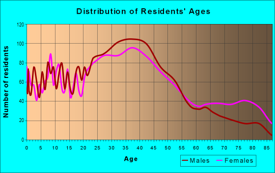
| Males: | 5,806 |
| Females: | 5,421 |
| Males: | 38.5 years |
| Females: | 43.4 years |
Average household size:
| West 7th-Fort Road: | 4.4 people |
| Minnesota: | 2.4 people |
Percentage of family households:
| West 7th-Fort Road: | 29.8% |
| Minnesota: | 45.6% |
| Here: | 26.8% |
| Minnesota: | 49.4% |
Percentage of married-couple families with children (among all households):
| West 7th-Fort Road: | 35.4% |
| Minnesota: | 53.9% |
Percentage of single-mother households (among all households):
| West 7th-Fort Road: | 26.1% |
| Minnesota: | 7.1% |
Percentage of never married males 15 years old and over:
Percentage of never married females 15 years old and over:
| West 7th-Fort Road: | 24.6% |
| Minnesota: | 17.9% |
Percentage of never married females 15 years old and over:
| West 7th-Fort Road: | 20.0% |
| Minnesota: | 15.2% |
Percentage of people that speak English not well or not at all:
| West 7th-Fort Road: | 1.5% |
| Minnesota: | 2.1% |
Percentage of people born in this state:
Percentage of people born in another U.S. state:
Percentage of native residents but born outside the U.S.:
Percentage of foreign born residents:
| Here: | 58.3% |
| Minnesota: | 67.2% |
Percentage of people born in another U.S. state:
| West 7th-Fort Road: | 31.5% |
| Minnesota: | 23.2% |
Percentage of native residents but born outside the U.S.:
| Here: | 1.4% |
| Minnesota: | 0.9% |
Percentage of foreign born residents:
| Here: | 9.1% |
| Minnesota: | 8.7% |
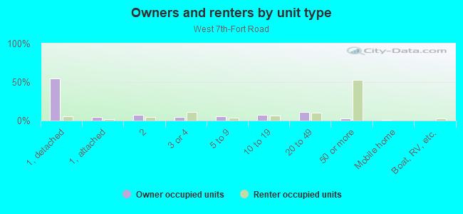
Owner-occupied
Renter-occupied

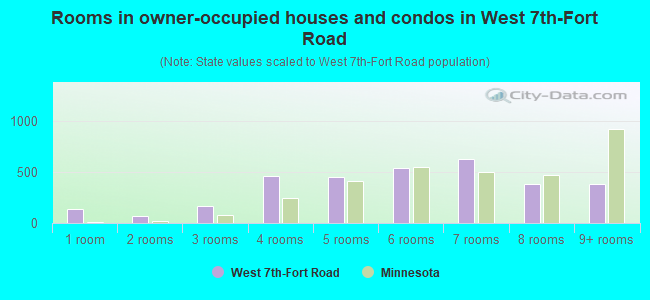
- Rooms in owner-occupied houses and condos in West 7th-Fort Road
- 1341 room
- 692 rooms
- 1643 rooms
- 4564 rooms
- 4555 rooms
- 5346 rooms
- 6317 rooms
- 3858 rooms
- 3859+ rooms
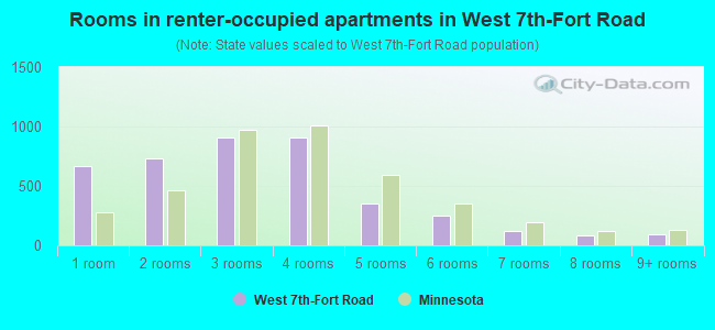
- Rooms in renter-occupied apartments in West 7th-Fort Road
- 6671 room
- 7362 rooms
- 9123 rooms
- 9034 rooms
- 3565 rooms
- 2496 rooms
- 1197 rooms
- 818 rooms
- 919+ rooms
Owner-occupied
Renter-occupied
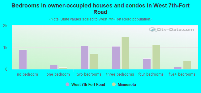
- Bedrooms in owner-occupied houses and condos in West 7th-Fort Road
- 899no bedroom
- 1961 bedroom
- 1,0642 bedrooms
- 1,0513 bedrooms
- 4984 bedrooms
- 995+ bedrooms
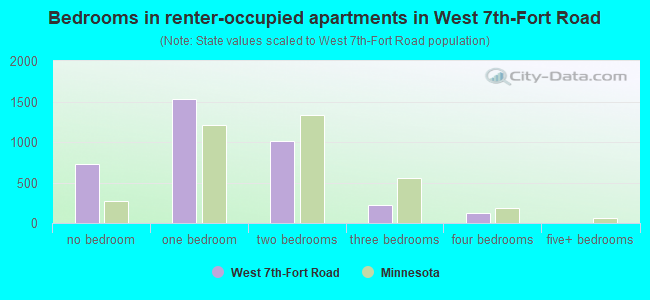
- Bedrooms in renter-occupied apartments in West 7th-Fort Road
- 732no bedroom
- 1,5351 bedroom
- 1,0122 bedrooms
- 2253 bedrooms
- 1294 bedrooms
- 05+ bedrooms
Average number of cars or other vehicles available in houses/condos:
Average number of cars or other vehicles available in apartments:
| This neighborhood: | 1.8 |
| Minnesota: | 2.1 |
Average number of cars or other vehicles available in apartments:
| Here: | 1.3 |
| Minnesota: | 1.3 |
Percentage of units with a mortgage:
| West 7th-Fort Road: | 66.5% |
| Minnesota: | 64.3% |
Housing prices:
- Average estimated value of detached houses in 2022 (42.3% of all units):
West 7th-Fort Road: $267,192 Minnesota: $374,552
- Average estimated value of townhouses or other attached units in 2022 (3.4% of all units):
This neighborhood: $269,803 Minnesota: $312,049
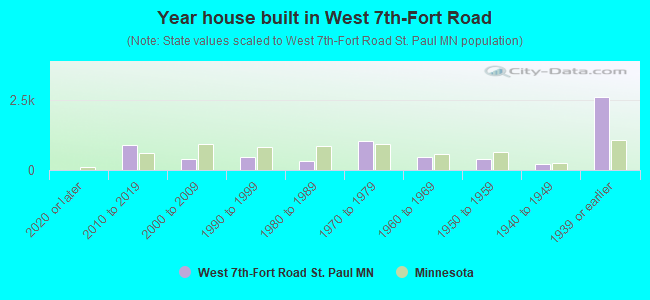
- Year house built in West 7th-Fort Road
- 92020 or later
- 8752010 to 2019
- 3982000 to 2009
- 4631990 to 1999
- 3381980 to 1989
- 1,0441970 to 1979
- 4571960 to 1969
- 3941950 to 1959
- 2211940 to 1949
- 2,5931939 or earlier
Travel time to work (commute)
![Travel time to work (commute)]()
- 118Less than 5 minutes
- 5925 to 9 minutes
- 80610 to 14 minutes
- 91215 to 19 minutes
- 1,08320 to 24 minutes
- 44725 to 29 minutes
- 62530 to 34 minutes
- 16335 to 39 minutes
- 8540 to 44 minutes
- 35845 to 59 minutes
- 18060 to 89 minutes
- 10890 or more minutes

Means of transportation to work
![Means of transportation to work]()
- 61.1%3,868Drove a car alone
- 10.6%671Carpooled
- 8.2%520Bus
- 0.3%17Subway or elevated rail
- 1.6%101Long-distance train or commuter rail
- 3.6%230Light rail, streetcar or trolley
- 2.3%143Bicycle
- 8.0%506Walked
- 1.0%62Other means
- 17.2%1,091Worked at home

Time leaving home to go to work
![Time leaving home to go to work]()
- 17612:00 a.m. to 4:59 a.m.
- 925:00 a.m. to 5:29 a.m.
- 2095:30 a.m. to 5:59 a.m.
- 3026:00 a.m. to 6:29 a.m.
- 5686:30 a.m. to 6:59 a.m.
- 5957:00 a.m. to 7:29 a.m.
- 6967:30 a.m. to 7:59 a.m.
- 7468:00 a.m. to 8:29 a.m.
- 4768:30 a.m. to 8:59 a.m.
- 3829:00 a.m. to 9:59 a.m.
- 27610:00 a.m. to 10:59 a.m.
- 11511:00 a.m. to 11:59 a.m.
- 62812:00 p.m. to 3:59 p.m.
- 2234:00 p.m. to 11:59 p.m.

Occupations of males:
- Percentage of males in management occupations (except farmers):
Here: 9.5% Minnesota: 13.1%
- Percentage of males in business and financial operations occupations:
Here: 7.0% Minnesota: 5.7%
- Percentage of males in computer and mathematical occupations:
Here: 3.7% Minnesota: 5.4%
- Percentage of males in architecture and engineering occupations:
Here: 3.5% Minnesota: 3.8%
- Percentage of males in life, physical, and social science occupations:
Here: 2.1% Minnesota: 1.2%
- Percentage of males in community and social services occupations:
Here: 1.7% Minnesota: 1.3%
- Percentage of males in education, training, and library occupations:
Here: 7.8% Minnesota: 3.2%
- Percentage of males in arts, design, entertainment, sports, and media occupations:
Here: 5.4% Minnesota: 1.8%
- Percentage of males in healthcare practitioners and technical occupations:
Here: 2.1% Minnesota: 2.9%
- Percentage of males in service occupations:
Here: 19.4% Minnesota: 11.5%
- Percentage of males in sales and office occupations:
Here: 17.7% Minnesota: 15.0%
- Percentage of males in construction, extraction, and maintenance occupations:
Here: 2.6% Minnesota: 8.1%
- Percentage of males in production occupations:
Here: 7.2% Minnesota: 9.3%
- Percentage of males in transportation occupations:
Here: 2.3% Minnesota: 5.7%
- Percentage of males in material moving occupations:
Here: 5.0% Minnesota: 4.8%
Occupations of females:
- Percentage of females in management occupations (except farmers):
Here: 11.5% Minnesota: 9.8%
- Percentage of females in business and financial operations occupations:
Here: 6.9% Minnesota: 7.7%
- Percentage of females in computer and mathematical occupations:
Here: 5.1% Minnesota: 2.1%
- Percentage of females in architecture and engineering occupations:
Here: 1.3% Minnesota: 0.8%
- Percentage of females in community and social services occupations:
Here: 3.4% Minnesota: 2.9%
- Percentage of females in legal occupations:
Here: 3.6% Minnesota: 1.2%
- Percentage of females in education, training, and library occupations:
Here: 14.0% Minnesota: 9.5%
- Percentage of females in arts, design, entertainment, sports, and media occupations:
Here: 3.2% Minnesota: 2.4%
- Percentage of females in healthcare practitioners and technical occupations:
Here: 8.5% Minnesota: 11.0%
- Percentage of females in service occupations:
Here: 19.7% Minnesota: 19.2%
- Percentage of females in sales and office occupations:
Here: 15.9% Minnesota: 24.4%
- Percentage of females in production occupations:
Here: 2.5% Minnesota: 4.0%
- Percentage of females in material moving occupations:
Here: 2.7% Minnesota: 1.9%
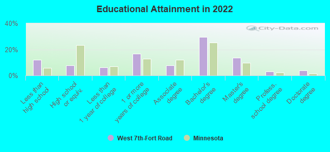
Education in this neighborhood (subdivision or community):
- Percentage of people 3 years and older in K-12 schools:
West 7th-Fort Road: 24.7% Minnesota: 17.3%
- Percentage of people 3 years and older in undergraduate colleges:
West 7th-Fort Road: 5.3% Minnesota: 4.5%
- Percentage of people 3 years and older in grad. or professional schools:
West 7th-Fort Road: 4.2% Minnesota: 1.3%
- Percentage of students K-12 enrolled in private schools:
West 7th-Fort Road: 59.0% Minnesota: 11.8%
Percentage of population below poverty level:
| West 7th-Fort Road: | 12.9% |
| Minnesota: | 9.6% |
Median year owner moved in (as recorded in 2022):
| West 7th-Fort Road: | 2008 |
| Minnesota: | 2011 |
Percentage of married-couple families with both working:
| West 7th-Fort Road: | 135.0% |
| Minnesota: | 81.3% |
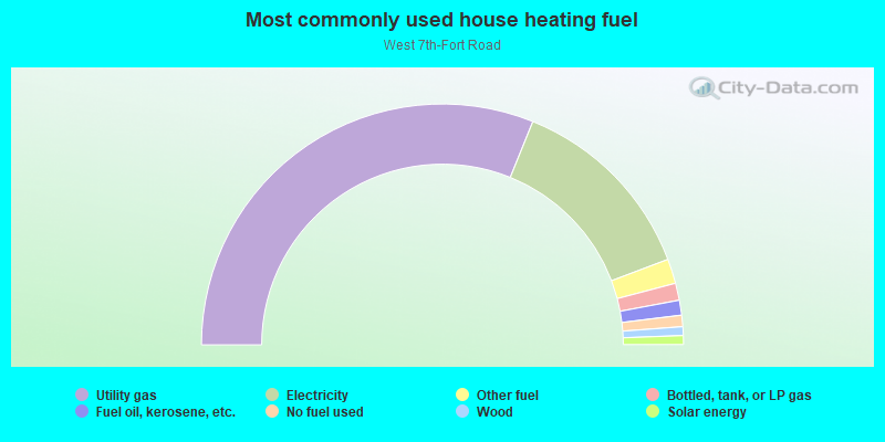
- 62.2%Utility gas
- 26.2%Electricity
- 3.3%Other fuel
- 2.3%Bottled, tank, or LP gas
- 2.0%Fuel oil, kerosene, etc.
- 1.5%No fuel used
- 1.2%Wood
- 1.2%Solar energy
Limited-access highways (interstate or state) in this neighborhood:
I- 35
Length: 2.48 miles
Directions: E-W, N-S, SE-NW, SW-NE
Directions: E-W, N-S, SE-NW, SW-NE
Roads and streets:
Shepard Rd
Length: 4.56 miles
Directions: E-W, SW-NE
Address range: 396 to 460
Directions: E-W, SW-NE
Address range: 396 to 460
7th St W (State Hwy 5, Fort Rd)
Length: 3.49 miles
Direction: SW-NE
Address range: 192 to 1699
Direction: SW-NE
Address range: 192 to 1699
W James Ave
Length: 1.87 miles
Direction: E-W
Address range: 300 to 1067
Direction: E-W
Address range: 300 to 1067
W Palace Ave
Length: 1.42 miles
Direction: E-W
Address range: 401 to 1051
Direction: E-W
Address range: 401 to 1051
Randolph Ave
Length: 1.34 miles
Direction: E-W
Address range: 570 to 999
Direction: E-W
Address range: 570 to 999
W Jefferson Ave
Length: 1.34 miles
Direction: E-W
Address range: 400 to 918
Direction: E-W
Address range: 400 to 918
W Armstrong Ave
Length: 1.25 miles
Direction: E-W
Address range: 600 to 1053
Direction: E-W
Address range: 600 to 1053
W Watson Ave
Length: 1.18 miles
Direction: E-W
Address range: 600 to 1099
Direction: E-W
Address range: 600 to 1099
W Tuscarora Ave
Length: 1.12 miles
Direction: E-W
Address range: 671 to 1100
Direction: E-W
Address range: 671 to 1100
W Juno Ave
Length: 1.09 miles
Direction: E-W
Address range: 600 to 1099
Direction: E-W
Address range: 600 to 1099
W Goodrich Ave
Length: 0.92 miles
Direction: E-W
Address range: 100 to 472
Direction: E-W
Address range: 100 to 472
Grace St
Length: 0.92 miles
Direction: E-W
Address range: 470 to 699
Direction: E-W
Address range: 470 to 699
Otto Ave
Length: 0.92 miles
Directions: E-W, SE-NW
Address range: 700 to 1061
Directions: E-W, SE-NW
Address range: 700 to 1061
Pleasant Ave
Length: 0.88 miles
Directions: E-W, N-S, SW-NE
Address range: 1014 to 1374
Directions: E-W, N-S, SW-NE
Address range: 1014 to 1374
St Clair Ave
Length: 0.87 miles
Direction: E-W
Address range: 300 to 624
Direction: E-W
Address range: 300 to 624
W Michigan St
Length: 0.85 miles
Direction: E-W
Address range: 300 to 700
Direction: E-W
Address range: 300 to 700
W Scheffer Ave
Length: 0.84 miles
Directions: E-W, SE-NW
Address range: 701 to 1071
Directions: E-W, SE-NW
Address range: 701 to 1071
State Hwy 149 (Smith Ave S)
Length: 0.83 miles
Directions: E-W, N-S, SE-NW, SW-NE
Address range: 344 to 500
Directions: E-W, N-S, SE-NW, SW-NE
Address range: 344 to 500
S Chatsworth St
Length: 0.82 miles
Direction: N-S
Address range: 300 to 799
Direction: N-S
Address range: 300 to 799
Bay St
Length: 0.79 miles
Directions: N-S, SE-NW
Address range: 299 to 700
Directions: N-S, SE-NW
Address range: 299 to 700
S Milton St
Length: 0.76 miles
Directions: N-S, SW-NE
Address range: 356 to 800
Directions: N-S, SW-NE
Address range: 356 to 800
Duke St
Length: 0.75 miles
Directions: N-S, SE-NW
Address range: 145 to 471
Directions: N-S, SE-NW
Address range: 145 to 471
Western Ave S
Length: 0.66 miles
Direction: N-S
Address range: 1 to 260
Direction: N-S
Address range: 1 to 260
W Superior St
Length: 0.63 miles
Direction: E-W
Address range: 200 to 600
Direction: E-W
Address range: 200 to 600
W Goodhue St
Length: 0.63 miles
Direction: E-W
Address range: 200 to 500
Direction: E-W
Address range: 200 to 500
N Chestnut St
Length: 0.62 miles
Direction: SE-NW
Address range: 100 to 400
Direction: SE-NW
Address range: 100 to 400
Osceola Ave
Length: 0.62 miles
Direction: N-S
Address range: 300 to 600
Direction: N-S
Address range: 300 to 600
Victoria St S
Length: 0.60 miles
Directions: N-S, SE-NW
Address range: 452 to 799
Directions: N-S, SE-NW
Address range: 452 to 799
Erie St
Length: 0.57 miles
Direction: N-S
Address range: 100 to 417
Direction: N-S
Address range: 100 to 417
Montreal Ave
Length: 0.57 miles
Directions: E-W, SW-NE
Address range: 1000 to 1130
Directions: E-W, SW-NE
Address range: 1000 to 1130
Bayard Ave
Length: 0.56 miles
Direction: E-W
Address range: 858 to 1100
Direction: E-W
Address range: 858 to 1100
View St
Length: 0.54 miles
Directions: N-S, SE-NW
Address range: 300 to 600
Directions: N-S, SE-NW
Address range: 300 to 600
Richmond St
Length: 0.49 miles
Direction: N-S
Address range: 100 to 299
Direction: N-S
Address range: 100 to 299
W Forbes Ave
Length: 0.48 miles
Direction: E-W
Address range: 100 to 299
Direction: E-W
Address range: 100 to 299
Eleanor Ave
Length: 0.46 miles
Directions: E-W, SE-NW
Address range: 800 to 1067
Directions: E-W, SE-NW
Address range: 800 to 1067
Hill St
Length: 0.45 miles
Directions: E-W, SW-NE
Directions: E-W, SW-NE
Toronto St
Length: 0.44 miles
Direction: N-S
Address range: 300 to 499
Direction: N-S
Address range: 300 to 499
Shepard Rd W
Length: 0.44 miles
Directions: E-W, N-S
Address range: 400 to 569
Directions: E-W, N-S
Address range: 400 to 569
N Smith Ave
Length: 0.43 miles
Direction: SW-NE
Address range: 1 to 499
Direction: SW-NE
Address range: 1 to 499
Benson Ave
Length: 0.43 miles
Directions: E-W, SW-NE
Address range: 1700 to 1953
Directions: E-W, SW-NE
Address range: 1700 to 1953
Grand Ave
Length: 0.43 miles
Direction: E-W
Address range: 1 to 300
Direction: E-W
Address range: 1 to 300
W Hill St
Length: 0.41 miles
Direction: SW-NE
Address range: 175 to 225
Direction: SW-NE
Address range: 175 to 225
S Oneida St
Length: 0.41 miles
Direction: N-S
Address range: 100 to 365
Direction: N-S
Address range: 100 to 365
Cliff St
Length: 0.40 miles
Directions: E-W, SW-NE
Address range: 200 to 399
Directions: E-W, SW-NE
Address range: 200 to 399
Eagle St
Length: 0.40 miles
Directions: E-W, SE-NW
Address range: 101 to 399
Directions: E-W, SE-NW
Address range: 101 to 399
Exchange St S
Length: 0.40 miles
Direction: SW-NE
Address range: 156 to 399
Direction: SW-NE
Address range: 156 to 399
Daly St
Length: 0.37 miles
Direction: N-S
Address range: 300 to 500
Direction: N-S
Address range: 300 to 500
S Stewart Ave
Length: 0.37 miles
Direction: SW-NE
Address range: 600 to 900
Direction: SW-NE
Address range: 600 to 900
N Walnut St
Length: 0.37 miles
Directions: E-W, SE-NW
Address range: 200 to 367
Directions: E-W, SE-NW
Address range: 200 to 367
W Palmer Pl
Length: 0.36 miles
Directions: N-S, SW-NE
Address range: 1300 to 1599
Directions: N-S, SW-NE
Address range: 1300 to 1599
W Banfil St
Length: 0.35 miles
Direction: E-W
Address range: 380 to 500
Direction: E-W
Address range: 380 to 500
W Sturgis St
Length: 0.35 miles
Direction: E-W
Address range: 200 to 400
Direction: E-W
Address range: 200 to 400
W Harrison Ave
Length: 0.35 miles
Direction: E-W
Address range: 200 to 478
Direction: E-W
Address range: 200 to 478
Irvine Park
Length: 0.32 miles
Directions: SE-NW, SW-NE
Address range: 1 to 61
Directions: SE-NW, SW-NE
Address range: 1 to 61
W Butternut Ave
Length: 0.31 miles
Direction: SW-NE
Address range: 600 to 799
Direction: SW-NE
Address range: 600 to 799
Spring Ln
Length: 0.30 miles
Direction: SW-NE
Direction: SW-NE
W Mc Boal St
Length: 0.28 miles
Direction: E-W
Address range: 100 to 299
Direction: E-W
Address range: 100 to 299
Arbor St
Length: 0.28 miles
Direction: N-S
Address range: 300 to 456
Direction: N-S
Address range: 300 to 456
Colborne St
Length: 0.28 miles
Direction: N-S
Address range: 300 to 499
Direction: N-S
Address range: 300 to 499
S Fulton St
Length: 0.28 miles
Direction: N-S
Address range: 352 to 500
Direction: N-S
Address range: 352 to 500
Webster St
Length: 0.28 miles
Direction: N-S
Address range: 300 to 599
Direction: N-S
Address range: 300 to 599
Selma Ln
Length: 0.26 miles
Directions: N-S, SE-NW
Address range: 901 to 1159
Directions: N-S, SE-NW
Address range: 901 to 1159
Vance St
Length: 0.26 miles
Direction: N-S
Address range: 300 to 499
Direction: N-S
Address range: 300 to 499
Harrison Ave
Length: 0.26 miles
Direction: SW-NE
Address range: 479 to 600
Direction: SW-NE
Address range: 479 to 600
Banfil St (W Banfil St)
Length: 0.26 miles
Direction: E-W
Address range: 100 to 310
Direction: E-W
Address range: 100 to 310
Victoria St N
Length: 0.25 miles
Direction: N-S
Address range: 316 to 451
Direction: N-S
Address range: 316 to 451
S Colborne St
Length: 0.25 miles
Directions: N-S, SW-NE
Address range: 100 to 300
Directions: N-S, SW-NE
Address range: 100 to 300
S Clifton St
Length: 0.25 miles
Direction: N-S
Address range: 354 to 500
Direction: N-S
Address range: 354 to 500
Rogers Ave
Length: 0.25 miles
Directions: N-S, SE-NW
Address range: 800 to 999
Directions: N-S, SE-NW
Address range: 800 to 999
S Leech St
Length: 0.24 miles
Direction: N-S
Address range: 1 to 199
Direction: N-S
Address range: 1 to 199
W Ryan Ave
Length: 0.24 miles
Direction: SW-NE
Address range: 100 to 400
Direction: SW-NE
Address range: 100 to 400
Sherman St
Length: 0.24 miles
Direction: SE-NW
Address range: 200 to 399
Direction: SE-NW
Address range: 200 to 399
Adrian St
Length: 0.23 miles
Directions: E-W, N-S, SE-NW, SW-NE
Address range: 1500 to 1799
Directions: E-W, N-S, SE-NW, SW-NE
Address range: 1500 to 1799
Ivan Way
Length: 0.23 miles
Directions: E-W, SE-NW
Address range: 1781 to 1899
Directions: E-W, SE-NW
Address range: 1781 to 1899
S Douglas St
Length: 0.22 miles
Direction: N-S
Address range: 1 to 199
Direction: N-S
Address range: 1 to 199
W Forster St
Length: 0.22 miles
Direction: E-W
Address range: 700 to 800
Direction: E-W
Address range: 700 to 800
W Bayard Ave
Length: 0.22 miles
Direction: E-W
Address range: 700 to 800
Direction: E-W
Address range: 700 to 800
S Canton St
Length: 0.22 miles
Directions: N-S, SE-NW
Address range: 600 to 800
Directions: N-S, SE-NW
Address range: 600 to 800
Dousman St
Length: 0.22 miles
Direction: N-S
Address range: 100 to 300
Direction: N-S
Address range: 100 to 300
Elway St
Length: 0.21 miles
Directions: N-S, SE-NW
Address range: 1100 to 1149
Directions: N-S, SE-NW
Address range: 1100 to 1149
Washington St
Length: 0.21 miles
Directions: E-W, SE-NW, SW-NE
Directions: E-W, SE-NW, SW-NE
W Race St
Length: 0.20 miles
Direction: SW-NE
Address range: 1500 to 1625
Direction: SW-NE
Address range: 1500 to 1625
Kellogg Blvd
Length: 0.19 miles
Directions: N-S, SE-NW
Directions: N-S, SE-NW
S Drake St
Length: 0.19 miles
Direction: N-S
Address range: 401 to 570
Direction: N-S
Address range: 401 to 570
Elm St
Length: 0.18 miles
Direction: SE-NW
Address range: 200 to 300
Direction: SE-NW
Address range: 200 to 300
Hathaway St
Length: 0.18 miles
Direction: SE-NW
Address range: 701 to 832
Direction: SE-NW
Address range: 701 to 832
Montreal Way
Length: 0.18 miles
Direction: SE-NW
Address range: 800 to 999
Direction: SE-NW
Address range: 800 to 999
Wilkin St
Length: 0.17 miles
Direction: N-S
Direction: N-S
S Ann St
Length: 0.15 miles
Direction: N-S
Address range: 100 to 299
Direction: N-S
Address range: 100 to 299
Glen Ter
Length: 0.14 miles
Directions: E-W, N-S, SE-NW, SW-NE
Address range: 1800 to 1900
Directions: E-W, N-S, SE-NW, SW-NE
Address range: 1800 to 1900
Emma St
Length: 0.13 miles
Direction: E-W
Address range: 300 to 400
Direction: E-W
Address range: 300 to 400
S Wilkin St
Length: 0.13 miles
Direction: N-S
Address range: 37 to 200
Direction: N-S
Address range: 37 to 200
Nugent St
Length: 0.13 miles
Direction: N-S
Address range: 200 to 299
Direction: N-S
Address range: 200 to 299
Spring St
Length: 0.13 miles
Direction: SW-NE
Direction: SW-NE
Monroe Ct
Length: 0.12 miles
Direction: E-W
Address range: 800 to 900
Direction: E-W
Address range: 800 to 900
S Garfield St
Length: 0.12 miles
Direction: N-S
Address range: 60 to 200
Direction: N-S
Address range: 60 to 200
Cullen St
Length: 0.11 miles
Directions: E-W, SW-NE
Directions: E-W, SW-NE
Palace Ave
Length: 0.09 miles
Direction: E-W
Direction: E-W
May St
Length: 0.09 miles
Direction: SE-NW
Address range: 801 to 899
Direction: SE-NW
Address range: 801 to 899
S Sumac St
Length: 0.09 miles
Directions: E-W, SE-NW
Address range: 601 to 699
Directions: E-W, SE-NW
Address range: 601 to 699
S Webster Ave
Length: 0.09 miles
Direction: N-S
Address range: 101 to 298
Direction: N-S
Address range: 101 to 298
I- 35 E Svc Rd
Length: 0.08 miles
Direction: E-W
Address range: 730 to 757
Direction: E-W
Address range: 730 to 757
Niederhoffer St
Length: 0.08 miles
Direction: E-W
Direction: E-W
Clay St
Length: 0.08 miles
Direction: E-W
Address range: 501 to 600
Direction: E-W
Address range: 501 to 600
Orrin St
Length: 0.08 miles
Direction: N-S
Address range: 600 to 699
Direction: N-S
Address range: 600 to 699
Leland St
Length: 0.08 miles
Directions: N-S, SE-NW
Address range: 800 to 899
Directions: N-S, SE-NW
Address range: 800 to 899
Oneida St
Length: 0.07 miles
Direction: N-S
Direction: N-S
W Middleton Ave
Length: 0.06 miles
Direction: SW-NE
Address range: 1500 to 1600
Direction: SW-NE
Address range: 1500 to 1600
Drake St
Length: 0.06 miles
Direction: N-S
Address range: 500 to 699
Direction: N-S
Address range: 500 to 699
Walnut St
Length: 0.05 miles
Direction: SE-NW
Direction: SE-NW
S Mercer St
Length: 0.05 miles
Directions: N-S, SE-NW
Address range: 600 to 800
Directions: N-S, SE-NW
Address range: 600 to 800
Jefferson Ave
Length: 0.04 miles
Direction: E-W
Direction: E-W
Clifton St
Length: 0.04 miles
Direction: N-S
Direction: N-S
Stewart Ave
Length: 0.03 miles
Direction: SW-NE
Direction: SW-NE
Wabasha St N
Length: 0.03 miles
Direction: SE-NW
Direction: SE-NW
Mercer St
Length: 0.02 miles
Direction: N-S
Direction: N-S
Douglas St
Length: 0.02 miles
Direction: N-S
Direction: N-S
Railroad features:
Canadian Pacific Rlwy
Length: 4.99 miles
Directions: E-W, SW-NE
Directions: E-W, SW-NE
Union Pacific RR
Length: 3.54 miles
Directions: E-W, N-S, SE-NW, SW-NE
Directions: E-W, N-S, SE-NW, SW-NE