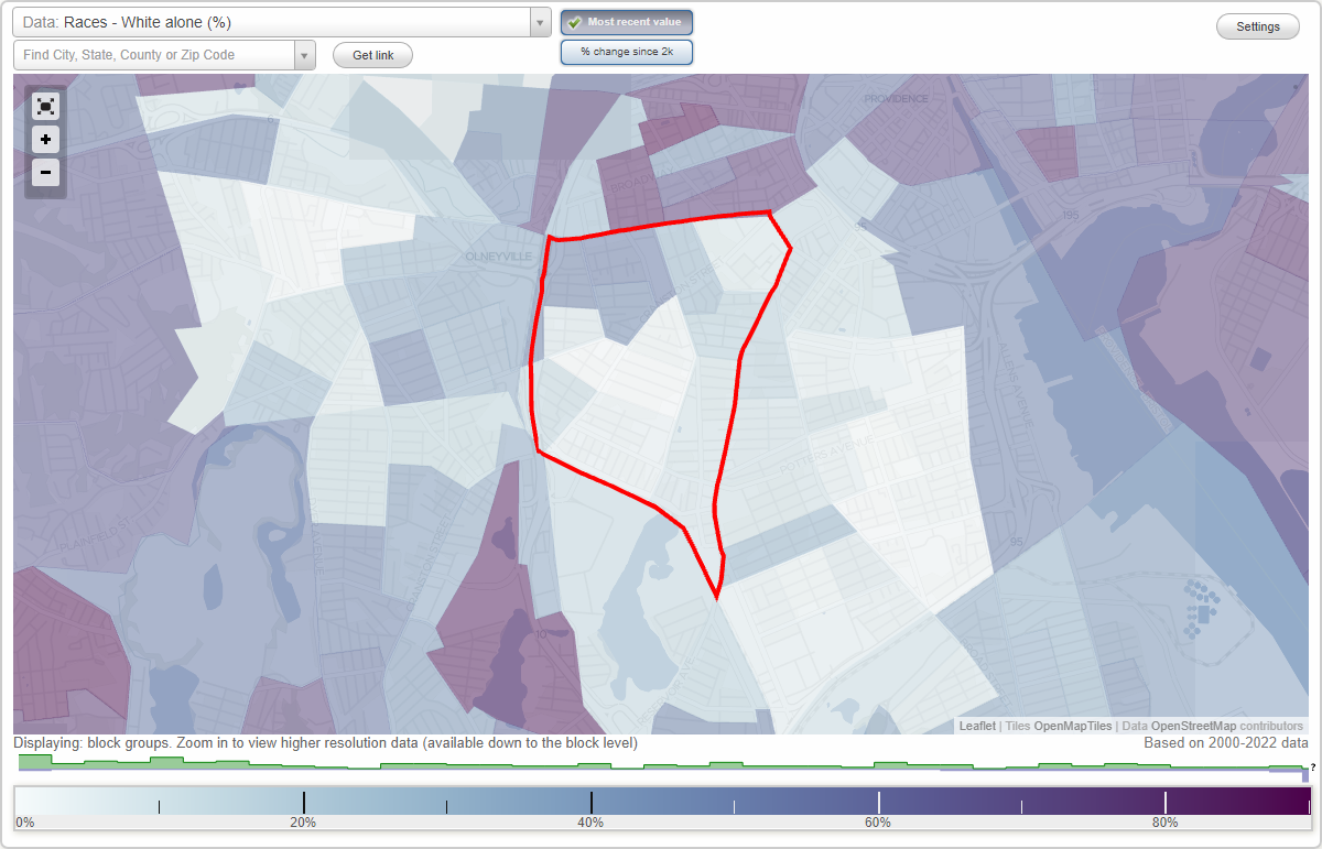
West End neighborhood in Providence, Rhode Island (RI), 02907, 02909 detailed profile
Settings
X

Business Search - 14 Million verified businesses
Area: 0.938 square miles
Population: 18,672
Population density:
| West End: | 19,913 people per square mile |
| Providence: | 10,266 people per square mile |

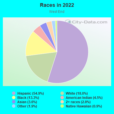
- 11,43654.9%Hispanic or Latino
- 3,75518.0%White
- 2,77213.3%Black
- 9384.5%American Indian
- 7553.6%Asian
- 5942.8%Two or more races
- 4011.9%Some other race
- 1920.9%Native Hawaiian and Other
Pacific Islander
Distribution of median household income
![Distribution of median household income]()
- 656Less than $10,000
- 1,326$10,000 to $19,999
- 619$20,000 to $29,999
- 1,238$30,000 to $39,999
- 812$40,000 to $49,999
- 525$50,000 to $59,999
- 1,260$60,000 to $74,999
- 1,214$75,000 to $99,999
- 633$100,000 to $124,999
- 694$125,000 to $149,999
- 672$150,000 to $199,999
- 344$200,000 or more

Distribution of owner-occupied house/condo value
![Distribution of owner-occupied house/condo value]()
- 251Less than $50,000
- 46$50,000 to $99,999
- 403$100,000 to $149,999
- 597$150,000 to $199,999
- 687$200,000 to $249,999
- 525$250,000 to $299,999
- 365$300,000 to $399,999
- 675$400,000 to $499,999
- 580$500,000 to $749,999
- 21$750,000 to $999,999
- 1,219$1,000,000 or more

Distribution of rent paid by renters
![Distribution of rent paid by renters]()
- 205Less than $100
- 1,798$100 to $199
- 1,033$200 to $299
- 1,271$300 to $399
- 435$400 to $499
- 679$500 to $599
- 345$600 to $699
- 909$700 to $799
- 700$800 to $899
- 1,011$900 to $999
- 1,423$1,000 to $1,249
- 730$1,250 to $1,499
- 735$1,500 to $1,999
- 329$2,000 or more

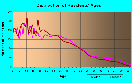
| Males: | 8,993 |
| Females: | 9,679 |
Males:
| This neighborhood: | 33.9 years |
| Whole city: | 32.9 years |
| This neighborhood: | 37.5 years |
| Whole city: | 32.4 years |
Average household size:
| West End: | 3.6 people |
| Providence: | 2.4 people |
Percentage of family households:
| West End: | 47.2% |
| Providence: | 37.9% |
| Here: | 31.2% |
| Providence: | 27.6% |
Percentage of married-couple families with children (among all households):
| West End: | 18.0% |
| Providence: | 17.7% |
Percentage of single-mother households (among all households):
| West End: | 16.1% |
| Providence: | 10.3% |
Percentage of never married males 15 years old and over:
Percentage of never married females 15 years old and over:
| West End: | 27.4% |
| Providence: | 26.8% |
Percentage of never married females 15 years old and over:
| West End: | 29.4% |
| city: | 28.2% |
Percentage of people that speak English not well or not at all:
| West End: | 22.7% |
| Providence: | 11.5% |
Percentage of people born in this state:
Percentage of people born in another U.S. state:
Percentage of native residents but born outside the U.S.:
Percentage of foreign born residents:
| Here: | 35.6% |
| Providence: | 30.5% |
Percentage of people born in another U.S. state:
| West End: | 17.3% |
| Providence: | 31.3% |
Percentage of native residents but born outside the U.S.:
| Here: | 5.3% |
| city: | 4.9% |
Percentage of foreign born residents:
| Here: | 41.8% |
| Providence: | 33.4% |
Owner-occupied
Renter-occupied

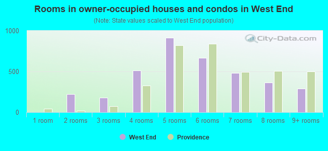
- Rooms in owner-occupied houses and condos in West End
- 01 room
- 2232 rooms
- 1773 rooms
- 5114 rooms
- 9155 rooms
- 6646 rooms
- 4817 rooms
- 3668 rooms
- 2889+ rooms
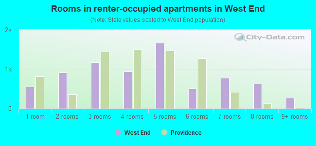
- Rooms in renter-occupied apartments in West End
- 5591 room
- 9142 rooms
- 1,1693 rooms
- 9434 rooms
- 1,6725 rooms
- 5096 rooms
- 7837 rooms
- 6268 rooms
- 2769+ rooms
Owner-occupied
Renter-occupied
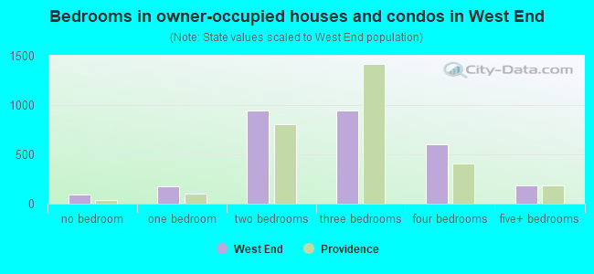
- Bedrooms in owner-occupied houses and condos in West End
- 97no bedroom
- 1781 bedroom
- 9432 bedrooms
- 9473 bedrooms
- 6004 bedrooms
- 1845+ bedrooms
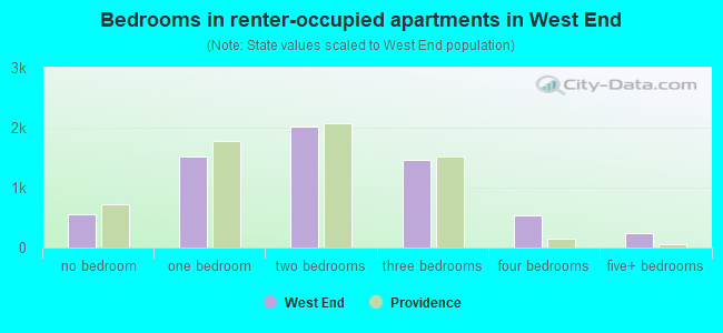
- Bedrooms in renter-occupied apartments in West End
- 556no bedroom
- 1,5131 bedroom
- 2,0232 bedrooms
- 1,4683 bedrooms
- 5284 bedrooms
- 2405+ bedrooms
Average number of cars or other vehicles available in houses/condos:
Average number of cars or other vehicles available in apartments:
| This neighborhood: | |
| Providence: |
Average number of cars or other vehicles available in apartments:
| Here: | 1.1 |
| city: | 1.0 |
Percentage of units with a mortgage:
| West End: | 72.9% |
| Providence: | 69.1% |
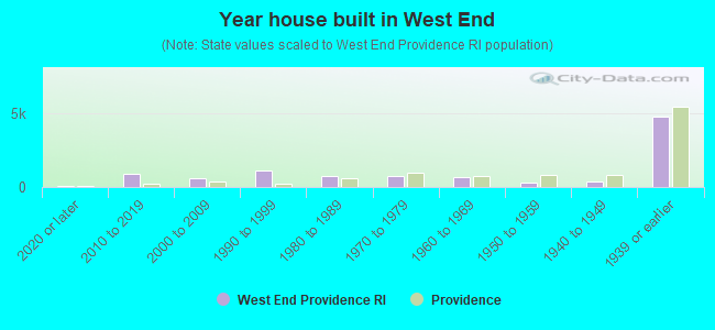
- Year house built in West End
- 1002020 or later
- 8702010 to 2019
- 5772000 to 2009
- 1,1071990 to 1999
- 7691980 to 1989
- 7271970 to 1979
- 6881960 to 1969
- 3251950 to 1959
- 4081940 to 1949
- 4,7911939 or earlier
City-data.com crime index for city in 2020 (higher means more crime):
| City: | 265.3 |
| U.S. average: | 219.5 |
Travel time to work (commute)
![Travel time to work (commute)]()
- 61Less than 5 minutes
- 2875 to 9 minutes
- 1,21010 to 14 minutes
- 1,79515 to 19 minutes
- 1,03120 to 24 minutes
- 50725 to 29 minutes
- 42130 to 34 minutes
- 2935 to 39 minutes
- 34540 to 44 minutes
- 1,07945 to 59 minutes
- 34760 to 89 minutes
- 30290 or more minutes

Means of transportation to work
![Means of transportation to work]()
- 64.1%5,034Drove a car alone
- 14.8%1,161Carpooled
- 9.2%725Bus
- 3.5%273Long-distance train or commuter rail
- 0.1%4Taxi
- 5.9%466Bicycle
- 4.5%356Walked
- 15.3%1,204Other means
- 17.9%1,404Worked at home

Time leaving home to go to work
![Time leaving home to go to work]()
- 46812:00 a.m. to 4:59 a.m.
- 2115:00 a.m. to 5:29 a.m.
- 1075:30 a.m. to 5:59 a.m.
- 1,1306:00 a.m. to 6:29 a.m.
- 3866:30 a.m. to 6:59 a.m.
- 9087:00 a.m. to 7:29 a.m.
- 5297:30 a.m. to 7:59 a.m.
- 1,5538:00 a.m. to 8:29 a.m.
- 1688:30 a.m. to 8:59 a.m.
- 3939:00 a.m. to 9:59 a.m.
- 15110:00 a.m. to 10:59 a.m.
- 14411:00 a.m. to 11:59 a.m.
- 67912:00 p.m. to 3:59 p.m.
- 5304:00 p.m. to 11:59 p.m.

Occupations of males:
- Percentage of males in management occupations (except farmers):
Here: 4.3% city: 8.8%
- Percentage of males in business and financial operations occupations:
Here: 1.7% city: 3.9%
- Percentage of males in computer and mathematical occupations:
Here: 5.7% city: 4.7%
- Percentage of males in architecture and engineering occupations:
Here: 1.5% city: 2.5%
- Percentage of males in community and social services occupations:
Here: 3.5% city: 2.2%
- Percentage of males in education, training, and library occupations:
Here: 3.4% city: 7.3%
- Percentage of males in arts, design, entertainment, sports, and media occupations:
Here: 1.9% city: 3.0%
- Percentage of males in healthcare practitioners and technical occupations:
Here: 1.8% city: 4.3%
- Percentage of males in service occupations:
Here: 12.5% city: 15.1%
- Percentage of males in sales and office occupations:
Here: 12.6% city: 14.9%
- Percentage of males in construction, extraction, and maintenance occupations:
Here: 11.0% city: 6.4%
- Percentage of males in production occupations:
Here: 12.8% city: 8.8%
- Percentage of males in transportation occupations:
Here: 13.9% city: 7.7%
- Percentage of males in material moving occupations:
Here: 9.2% city: 5.1%
Occupations of females:
- Percentage of females in management occupations (except farmers):
Here: 8.2% city: 8.1%
- Percentage of females in business and financial operations occupations:
Here: 2.6% city: 4.1%
- Percentage of females in life, physical, and social science occupations:
Here: 2.2% city: 1.9%
- Percentage of females in education, training, and library occupations:
Here: 8.3% city: 9.3%
- Percentage of females in arts, design, entertainment, sports, and media occupations:
Here: 1.8% city: 3.3%
- Percentage of females in healthcare practitioners and technical occupations:
Here: 5.4% city: 7.1%
- Percentage of females in service occupations:
Here: 38.1% city: 26.3%
- Percentage of females in sales and office occupations:
Here: 17.5% city: 21.8%
- Percentage of females in production occupations:
Here: 9.6% city: 5.4%
- Percentage of females in transportation occupations:
Here: 2.0% city: 0.9%
- Percentage of females in material moving occupations:
Here: 2.6% city: 4.2%
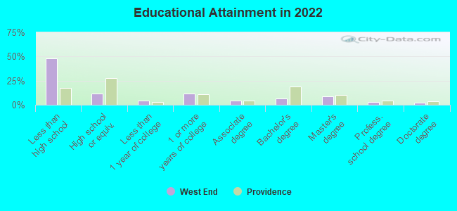
Education in this neighborhood (subdivision or community):
- Percentage of people 3 years and older in K-12 schools:
West End: 38.8% Providence: 17.2%
- Percentage of people 3 years and older in undergraduate colleges:
West End: 6.3% Providence: 11.1%
- Percentage of people 3 years and older in grad. or professional schools:
West End: 3.0% Providence: 3.3%
- Percentage of students K-12 enrolled in private schools:
West End: 22.7% Providence: 13.0%
Percentage of population below poverty level:
| West End: | 24.6% |
| Providence: | 21.0% |
Percentage of married-couple families with both working:
| West End: | 127.1% |
| Providence: | 66.2% |
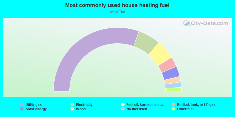
- 60.9%Utility gas
- 11.4%Electricity
- 9.8%Fuel oil, kerosene, etc.
- 5.2%Bottled, tank, or LP gas
- 5.2%Solar energy
- 2.9%Wood
- 2.7%No fuel used
- 1.9%Other fuel
Highways in this neighborhood:
US Hwy 1 (Elmwood Ave)
Length: 1.17 miles
Directions: N-S, SW-NE
Address range: 1 to 482
Directions: N-S, SW-NE
Address range: 1 to 482
State Hwy 10
Length: 0.57 miles
Direction: N-S
Direction: N-S
US Hwy 1 (Broad St)
Length: 0.21 miles
Directions: N-S, SW-NE
Address range: 280 to 362
Directions: N-S, SW-NE
Address range: 280 to 362
Reservoir Ave (State Hwy 2)
Length: 0.16 miles
Directions: N-S, SW-NE
Address range: 15 to 48
Directions: N-S, SW-NE
Address range: 15 to 48
US Hwy 6 (State Hwy 195)
Length: 0.15 miles
Directions: E-W, N-S, SW-NE
Directions: E-W, N-S, SW-NE
Roads and streets:
Huntington Ave
Length: 2.12 miles
Directions: E-W, N-S, SE-NW, SW-NE
Address range: 400 to 798
Directions: E-W, N-S, SE-NW, SW-NE
Address range: 400 to 798
Cranston St
Length: 1.55 miles
Directions: E-W, SW-NE
Address range: 1 to 778
Directions: E-W, SW-NE
Address range: 1 to 778
Dexter St
Length: 1.11 miles
Directions: N-S, SE-NW, SW-NE
Address range: 16 to 599
Directions: N-S, SE-NW, SW-NE
Address range: 16 to 599
Potters Ave
Length: 0.83 miles
Direction: E-W
Address range: 521 to 858
Direction: E-W
Address range: 521 to 858
Waverly St
Length: 0.80 miles
Directions: E-W, SE-NW
Address range: 1 to 302
Directions: E-W, SE-NW
Address range: 1 to 302
Althea St
Length: 0.78 miles
Directions: E-W, SE-NW
Address range: 1 to 303
Directions: E-W, SE-NW
Address range: 1 to 303
Bucklin St
Length: 0.77 miles
Directions: N-S, SE-NW
Address range: 1 to 360
Directions: N-S, SE-NW
Address range: 1 to 360
Linwood Ave
Length: 0.74 miles
Directions: E-W, SE-NW
Address range: 1 to 299
Directions: E-W, SE-NW
Address range: 1 to 299
Waldo St
Length: 0.73 miles
Directions: E-W, SE-NW
Address range: 1 to 303
Directions: E-W, SE-NW
Address range: 1 to 303
Bellevue Ave
Length: 0.65 miles
Direction: E-W
Address range: 1 to 247
Direction: E-W
Address range: 1 to 247
Wadsworth St
Length: 0.61 miles
Directions: E-W, SE-NW
Address range: 1 to 299
Directions: E-W, SE-NW
Address range: 1 to 299
Chapin Ave
Length: 0.60 miles
Direction: E-W
Address range: 1 to 208
Direction: E-W
Address range: 1 to 208
Benedict St
Length: 0.59 miles
Directions: E-W, SE-NW
Address range: 1 to 215
Directions: E-W, SE-NW
Address range: 1 to 215
Wendell St
Length: 0.59 miles
Direction: E-W
Address range: 1 to 223
Direction: E-W
Address range: 1 to 223
Hanover St
Length: 0.58 miles
Direction: E-W
Address range: 1 to 299
Direction: E-W
Address range: 1 to 299
Wood St
Length: 0.55 miles
Direction: E-W
Address range: 1 to 198
Direction: E-W
Address range: 1 to 198
Bridgham St
Length: 0.54 miles
Directions: E-W, SE-NW
Address range: 1 to 153
Directions: E-W, SE-NW
Address range: 1 to 153
Hudson St
Length: 0.53 miles
Direction: E-W
Address range: 1 to 184
Direction: E-W
Address range: 1 to 184
Ford St
Length: 0.51 miles
Direction: E-W
Address range: 1 to 205
Direction: E-W
Address range: 1 to 205
Willow St
Length: 0.50 miles
Direction: E-W
Address range: 1 to 199
Direction: E-W
Address range: 1 to 199
Union Ave
Length: 0.50 miles
Directions: E-W, N-S
Address range: 1 to 138
Directions: E-W, N-S
Address range: 1 to 138
Messer St
Length: 0.46 miles
Directions: E-W, N-S
Address range: 29 to 245
Directions: E-W, N-S
Address range: 29 to 245
Harrison St
Length: 0.45 miles
Directions: N-S, SE-NW
Address range: 8 to 237
Directions: N-S, SE-NW
Address range: 8 to 237
Service Rd
Length: 0.44 miles
Directions: E-W, N-S, SW-NE
Directions: E-W, N-S, SW-NE
Wilson St
Length: 0.41 miles
Direction: E-W
Address range: 1 to 159
Direction: E-W
Address range: 1 to 159
Parade St
Length: 0.39 miles
Directions: N-S, SE-NW
Address range: 15 to 181
Directions: N-S, SE-NW
Address range: 15 to 181
Oak St
Length: 0.39 miles
Direction: E-W
Address range: 1 to 161
Direction: E-W
Address range: 1 to 161
Anthony Ave
Length: 0.38 miles
Directions: E-W, SE-NW
Address range: 1 to 99
Directions: E-W, SE-NW
Address range: 1 to 99
Superior St
Length: 0.36 miles
Direction: E-W
Address range: 25 to 176
Direction: E-W
Address range: 25 to 176
Warren St
Length: 0.36 miles
Direction: E-W
Address range: 1 to 99
Direction: E-W
Address range: 1 to 99
Sorrento St
Length: 0.36 miles
Direction: SW-NE
Address range: 1 to 152
Direction: SW-NE
Address range: 1 to 152
Sprague St
Length: 0.34 miles
Direction: E-W
Address range: 1 to 135
Direction: E-W
Address range: 1 to 135
Rosedale St
Length: 0.33 miles
Direction: E-W
Address range: 1 to 130
Direction: E-W
Address range: 1 to 130
Westfield St
Length: 0.32 miles
Direction: E-W
Address range: 1 to 199
Direction: E-W
Address range: 1 to 199
Mawney St
Length: 0.32 miles
Direction: E-W
Address range: 53 to 184
Direction: E-W
Address range: 53 to 184
Burnett St
Length: 0.32 miles
Direction: E-W
Address range: 41 to 163
Direction: E-W
Address range: 41 to 163
Daboll St
Length: 0.32 miles
Direction: E-W
Address range: 157 to 299
Direction: E-W
Address range: 157 to 299
Ellery St
Length: 0.31 miles
Direction: N-S
Address range: 1 to 132
Direction: N-S
Address range: 1 to 132
Peace St
Length: 0.28 miles
Direction: E-W
Address range: 121 to 219
Direction: E-W
Address range: 121 to 219
Arch St
Length: 0.27 miles
Direction: E-W
Address range: 1 to 71
Direction: E-W
Address range: 1 to 71
Greenwich St
Length: 0.27 miles
Direction: E-W
Address range: 16 to 99
Direction: E-W
Address range: 16 to 99
Cromwell St
Length: 0.23 miles
Direction: E-W
Address range: 1 to 87
Direction: E-W
Address range: 1 to 87
Sycamore St
Length: 0.23 miles
Direction: N-S
Address range: 29 to 150
Direction: N-S
Address range: 29 to 150
Central St
Length: 0.22 miles
Directions: E-W, SE-NW, SW-NE
Address range: 1 to 64
Directions: E-W, SE-NW, SW-NE
Address range: 1 to 64
Woodman St
Length: 0.22 miles
Direction: E-W
Address range: 1 to 79
Direction: E-W
Address range: 1 to 79
Salvati Way
Length: 0.22 miles
Directions: N-S, SE-NW, SW-NE
Address range: 1 to 299
Directions: N-S, SE-NW, SW-NE
Address range: 1 to 299
Lester St
Length: 0.22 miles
Directions: E-W, SW-NE
Address range: 100 to 199
Directions: E-W, SW-NE
Address range: 100 to 199
Durfee St
Length: 0.21 miles
Directions: E-W, SW-NE
Address range: 1 to 73
Directions: E-W, SW-NE
Address range: 1 to 73
Powhatan St
Length: 0.20 miles
Directions: E-W, SE-NW
Address range: 1 to 55
Directions: E-W, SE-NW
Address range: 1 to 55
Dodge St
Length: 0.20 miles
Direction: SE-NW
Address range: 1 to 187
Direction: SE-NW
Address range: 1 to 187
Division St
Length: 0.20 miles
Direction: E-W
Address range: 1 to 99
Direction: E-W
Address range: 1 to 99
Diamond St
Length: 0.20 miles
Directions: N-S, SE-NW
Address range: 1 to 102
Directions: N-S, SE-NW
Address range: 1 to 102
Carter St
Length: 0.19 miles
Directions: E-W, SE-NW
Address range: 1 to 87
Directions: E-W, SE-NW
Address range: 1 to 87
Whitmarsh St
Length: 0.19 miles
Direction: E-W
Address range: 130 to 201
Direction: E-W
Address range: 130 to 201
Princeton Ave
Length: 0.18 miles
Direction: E-W
Address range: 139 to 215
Direction: E-W
Address range: 139 to 215
Gilmore St
Length: 0.18 miles
Directions: N-S, SE-NW
Address range: 1 to 54
Directions: N-S, SE-NW
Address range: 1 to 54
Marvin St
Length: 0.17 miles
Direction: E-W
Address range: 1 to 99
Direction: E-W
Address range: 1 to 99
Hollis St
Length: 0.17 miles
Directions: E-W, SE-NW
Address range: 1 to 70
Directions: E-W, SE-NW
Address range: 1 to 70
Fricker St
Length: 0.17 miles
Direction: SE-NW
Address range: 40 to 121
Direction: SE-NW
Address range: 40 to 121
Brattle St
Length: 0.16 miles
Directions: N-S, SW-NE
Address range: 1 to 108
Directions: N-S, SW-NE
Address range: 1 to 108
Redwing St
Length: 0.15 miles
Direction: E-W
Address range: 1 to 67
Direction: E-W
Address range: 1 to 67
Hawthorne St
Length: 0.15 miles
Direction: E-W
Address range: 1 to 41
Direction: E-W
Address range: 1 to 41
Salem St
Length: 0.14 miles
Direction: SW-NE
Address range: 1 to 78
Direction: SW-NE
Address range: 1 to 78
Hammond St
Length: 0.14 miles
Directions: N-S, SE-NW
Address range: 17 to 99
Directions: N-S, SE-NW
Address range: 17 to 99
Vineyard St
Length: 0.14 miles
Direction: N-S
Address range: 1 to 71
Direction: N-S
Address range: 1 to 71
Hollywood Rd
Length: 0.14 miles
Direction: E-W
Address range: 1 to 51
Direction: E-W
Address range: 1 to 51
Cowper Ct
Length: 0.14 miles
Direction: E-W
Address range: 1 to 68
Direction: E-W
Address range: 1 to 68
Fuller St
Length: 0.13 miles
Direction: N-S
Address range: 1 to 63
Direction: N-S
Address range: 1 to 63
Perkins St
Length: 0.13 miles
Direction: SW-NE
Address range: 1 to 33
Direction: SW-NE
Address range: 1 to 33
Rice St
Length: 0.13 miles
Direction: SW-NE
Address range: 1 to 99
Direction: SW-NE
Address range: 1 to 99
Plymouth St
Length: 0.13 miles
Direction: SW-NE
Address range: 1 to 65
Direction: SW-NE
Address range: 1 to 65
Calder St
Length: 0.13 miles
Direction: SW-NE
Address range: 1 to 68
Direction: SW-NE
Address range: 1 to 68
Puritan St
Length: 0.13 miles
Direction: SW-NE
Address range: 1 to 64
Direction: SW-NE
Address range: 1 to 64
Chambers St
Length: 0.13 miles
Direction: SW-NE
Address range: 1 to 67
Direction: SW-NE
Address range: 1 to 67
Seabury St
Length: 0.13 miles
Direction: SW-NE
Address range: 1 to 65
Direction: SW-NE
Address range: 1 to 65
Grand St
Length: 0.13 miles
Direction: SW-NE
Address range: 1 to 67
Direction: SW-NE
Address range: 1 to 67
Calhoun Ave
Length: 0.13 miles
Direction: SW-NE
Address range: 1 to 61
Direction: SW-NE
Address range: 1 to 61
Ninigret Ave
Length: 0.13 miles
Direction: SW-NE
Address range: 1 to 58
Direction: SW-NE
Address range: 1 to 58
Homestead Ave
Length: 0.12 miles
Direction: SW-NE
Address range: 1 to 61
Direction: SW-NE
Address range: 1 to 61
Madison St
Length: 0.12 miles
Directions: N-S, SW-NE
Address range: 1 to 65
Directions: N-S, SW-NE
Address range: 1 to 65
Noyes Ave
Length: 0.12 miles
Direction: SW-NE
Address range: 1 to 61
Direction: SW-NE
Address range: 1 to 61
Halton St
Length: 0.12 miles
Direction: SW-NE
Address range: 1 to 99
Direction: SW-NE
Address range: 1 to 99
Avon St
Length: 0.12 miles
Directions: N-S, SE-NW, SW-NE
Address range: 1 to 24
Directions: N-S, SE-NW, SW-NE
Address range: 1 to 24
Sherry St
Length: 0.11 miles
Directions: N-S, SW-NE
Directions: N-S, SW-NE
Kenwood St
Length: 0.11 miles
Direction: SW-NE
Address range: 1 to 58
Direction: SW-NE
Address range: 1 to 58
Groton St
Length: 0.11 miles
Direction: SE-NW
Address range: 1 to 30
Direction: SE-NW
Address range: 1 to 30
Buffalo Ct
Length: 0.11 miles
Direction: E-W
Address range: 1 to 34
Direction: E-W
Address range: 1 to 34
Constitution St
Length: 0.10 miles
Directions: N-S, SE-NW
Address range: 1 to 51
Directions: N-S, SE-NW
Address range: 1 to 51
A St
Length: 0.10 miles
Direction: SE-NW
Address range: 1 to 99
Direction: SE-NW
Address range: 1 to 99
Burgess St
Length: 0.10 miles
Direction: SE-NW
Direction: SE-NW
Pearl St
Length: 0.10 miles
Direction: SE-NW
Address range: 274 to 399
Direction: SE-NW
Address range: 274 to 399
Booth St
Length: 0.09 miles
Direction: SW-NE
Address range: 1 to 33
Direction: SW-NE
Address range: 1 to 33
Gilbert St
Length: 0.09 miles
Direction: E-W
Address range: 2 to 99
Direction: E-W
Address range: 2 to 99
Lester (Lester St)
Length: 0.09 miles
Direction: SW-NE
Address range: 1 to 99
Direction: SW-NE
Address range: 1 to 99
Rutland St
Length: 0.08 miles
Direction: E-W
Address range: 1 to 39
Direction: E-W
Address range: 1 to 39
Earl St
Length: 0.08 miles
Directions: E-W, SE-NW
Address range: 1 to 29
Directions: E-W, SE-NW
Address range: 1 to 29
Mashapaug St
Length: 0.08 miles
Direction: N-S
Address range: 1 to 99
Direction: N-S
Address range: 1 to 99
Palm St
Length: 0.07 miles
Direction: N-S
Address range: 1 to 99
Direction: N-S
Address range: 1 to 99
Luther St (Luther)
Length: 0.07 miles
Direction: SE-NW
Address range: 1 to 98
Direction: SE-NW
Address range: 1 to 98
Moore St
Length: 0.06 miles
Direction: E-W
Address range: 144 to 199
Direction: E-W
Address range: 144 to 199
Kendall St
Length: 0.06 miles
Direction: SW-NE
Address range: 1 to 31
Direction: SW-NE
Address range: 1 to 31
Fales St
Length: 0.05 miles
Direction: N-S
Address range: 1 to 99
Direction: N-S
Address range: 1 to 99
Junction St
Length: 0.05 miles
Direction: N-S
Direction: N-S
Carol Ct
Length: 0.04 miles
Direction: N-S
Address range: 1 to 28
Direction: N-S
Address range: 1 to 28
Hanover St (Hanover)
Length: 0.04 miles
Direction: E-W
Address range: 84 to 95
Direction: E-W
Address range: 84 to 95
Bianco Ct
Length: 0.04 miles
Direction: N-S
Address range: 1 to 65
Direction: N-S
Address range: 1 to 65
Dexter St (Dexter)
Length: 0.03 miles
Directions: N-S, SE-NW
Address range: 462 to 477
Directions: N-S, SE-NW
Address range: 462 to 477
Ware Ct
Length: 0.03 miles
Direction: SW-NE
Address range: 1 to 18
Direction: SW-NE
Address range: 1 to 18
Betteridge Ct
Length: 0.03 miles
Direction: E-W
Address range: 1 to 99
Direction: E-W
Address range: 1 to 99
Theresa Ct
Length: 0.03 miles
Direction: N-S
Address range: 1 to 13
Direction: N-S
Address range: 1 to 13
Hadley Ct
Length: 0.02 miles
Direction: N-S
Direction: N-S
Lytherland Pl
Length: 0.02 miles
Direction: N-S
Address range: 1 to 99
Direction: N-S
Address range: 1 to 99
Ford (Ford St)
Length: 0.02 miles
Direction: SE-NW
Address range: 1 to 8
Direction: SE-NW
Address range: 1 to 8
Railroad features:
Amtrak
Length: 0.85 miles
Directions: E-W, SE-NW
Directions: E-W, SE-NW
New York New Haven and Hartford RR
Length: 0.72 miles
Directions: E-W, SE-NW
Directions: E-W, SE-NW