Woodlands (Woodland) neighborhood in Mansfield, Ohio (OH), 44903, 44906, 44907 detailed profile
Settings
X


Business Search - 14 Million verified businesses
Area: 1.670 square miles
Population: 3,111
Population density:
| Woodlands (Woodland): | 1,863 people per square mile |
| Mansfield: | 1,593 people per square mile |

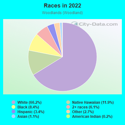
- 2,43966.2%White
- 43711.9%Native Hawaiian and Other
Pacific Islander - 3088.4%Black
- 2256.1%Two or more races
- 1253.4%Hispanic or Latino
- 1012.7%Some other race
- 421.1%Asian
- 70.2%American Indian
Median household income in 2022:
| Woodlands (Woodland): | $47,246 |
| Mansfield: | $40,996 |
Distribution of median household income
![Distribution of median household income]()
- 50Less than $10,000
- 144$10,000 to $19,999
- 111$20,000 to $29,999
- 215$30,000 to $39,999
- 101$40,000 to $49,999
- 93$50,000 to $59,999
- 150$60,000 to $74,999
- 170$75,000 to $99,999
- 91$100,000 to $124,999
- 89$125,000 to $149,999
- 77$150,000 to $199,999
- 68$200,000 or more

Distribution of owner-occupied house/condo value
![Distribution of owner-occupied house/condo value]()
- 242Less than $50,000
- 406$50,000 to $99,999
- 237$100,000 to $149,999
- 217$150,000 to $199,999
- 48$200,000 to $249,999
- 97$250,000 to $299,999
- 45$300,000 to $399,999
- 20$400,000 to $499,999
- 14$500,000 to $749,999
- 8$1,000,000 or more

Distribution of rent paid by renters
![Distribution of rent paid by renters]()
- 217$100 to $199
- 139$200 to $299
- 326$300 to $399
- 80$400 to $499
- 151$500 to $599
- 86$600 to $699
- 225$700 to $799
- 7$800 to $899
- 46$900 to $999
- 13$1,000 to $1,249
- 15$1,250 to $1,499
- 6$1,500 to $1,999
- 52$2,000 or more

Median rent in 2022:
| Woodlands (Woodland): | $637 |
| Mansfield: | $571 |
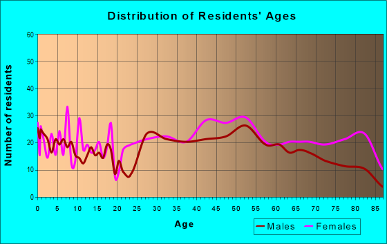
| Males: | 1,314 |
| Females: | 1,796 |
Males:
| This neighborhood: | 37.8 years |
| Whole city: | 37.4 years |
| This neighborhood: | 44.7 years |
| Whole city: | 42.1 years |
Average household size:
| Woodlands (Woodland): | 3.8 people |
| Mansfield: | 2.2 people |
Percentage of family households:
| Woodlands (Woodland): | 37.2% |
| Mansfield: | 34.5% |
| Here: | 35.7% |
| Mansfield: | 27.9% |
Percentage of married-couple families with children (among all households):
| Woodlands (Woodland): | 31.7% |
| Mansfield: | 17.4% |
Percentage of single-mother households (among all households):
| Woodlands (Woodland): | 8.9% |
| Mansfield: | 19.2% |
Percentage of never married males 15 years old and over:
Percentage of never married females 15 years old and over:
| Woodlands (Woodland): | 12.1% |
| Mansfield: | 26.3% |
Percentage of never married females 15 years old and over:
| Woodlands (Woodland): | 22.8% |
| city: | 15.9% |
Percentage of people that speak English not well or not at all:
| Woodlands (Woodland): | 0.6% |
| Mansfield: | 0.6% |
Percentage of people born in this state:
Percentage of people born in another U.S. state:
Percentage of native residents but born outside the U.S.:
Percentage of foreign born residents:
| Here: | 75.5% |
| Mansfield: | 77.5% |
Percentage of people born in another U.S. state:
| Woodlands (Woodland): | 21.2% |
| Mansfield: | 20.1% |
Percentage of native residents but born outside the U.S.:
| Here: | 0.4% |
| city: | 0.6% |
Percentage of foreign born residents:
| Here: | 2.9% |
| Mansfield: | 1.8% |
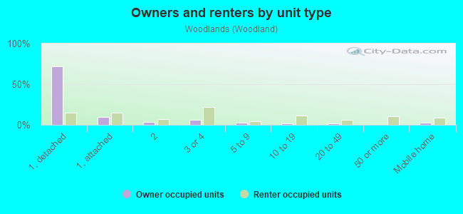
Owner-occupied
Renter-occupied

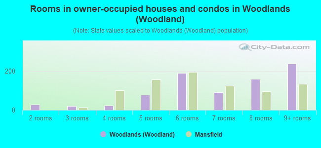
- Rooms in owner-occupied houses and condos in Woodlands <
> - 01 room
- 272 rooms
- 193 rooms
- 224 rooms
- 775 rooms
- 1886 rooms
- 917 rooms
- 1598 rooms
- 2379+ rooms
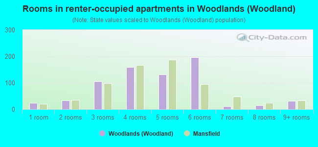
- Rooms in renter-occupied apartments in Woodlands <
> - 251 room
- 332 rooms
- 1053 rooms
- 1594 rooms
- 1315 rooms
- 1976 rooms
- 127 rooms
- 158 rooms
- 329+ rooms
Owner-occupied
Renter-occupied
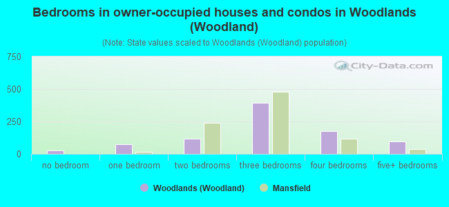
- Bedrooms in owner-occupied houses and condos in Woodlands <
> - 27no bedroom
- 751 bedroom
- 1192 bedrooms
- 3923 bedrooms
- 1784 bedrooms
- 975+ bedrooms
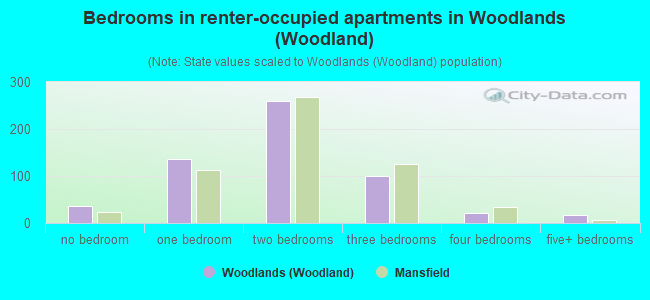
- Bedrooms in renter-occupied apartments in Woodlands <
> - 37no bedroom
- 1371 bedroom
- 2592 bedrooms
- 1003 bedrooms
- 224 bedrooms
- 185+ bedrooms
Average number of cars or other vehicles available in houses/condos:
Average number of cars or other vehicles available in apartments:
| This neighborhood: | 2.3 |
| Mansfield: | 1.8 |
Average number of cars or other vehicles available in apartments:
| Here: | 0.9 |
| city: | 1.2 |
Percentage of units with a mortgage:
| Woodlands (Woodland): | 59.9% |
| Mansfield: | 53.5% |
Average estimated value of detached houses in 2022 (58.4% of all units):
| Woodlands (Woodland): | $90,893 |
| Mansfield: | $134,529 |
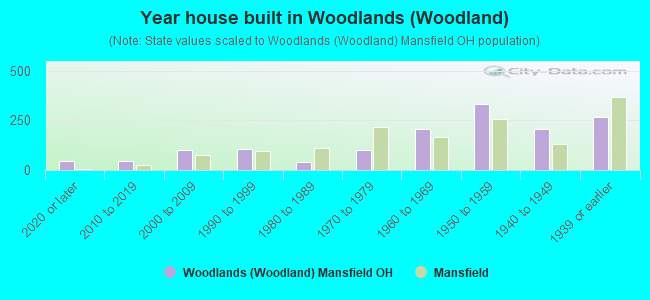
- Year house built in Woodlands <
> - 432020 or later
- 442010 to 2019
- 1012000 to 2009
- 1081990 to 1999
- 401980 to 1989
- 1011970 to 1979
- 2071960 to 1969
- 3341950 to 1959
- 2051940 to 1949
- 2691939 or earlier
City-data.com crime index for city in 2020 (higher means more crime):
| City: | 173.2 |
| U.S. average: | 219.5 |
Travel time to work (commute)
![Travel time to work (commute)]()
- 111Less than 5 minutes
- 3965 to 9 minutes
- 19810 to 14 minutes
- 17315 to 19 minutes
- 15720 to 24 minutes
- 7825 to 29 minutes
- 4930 to 34 minutes
- 14335 to 39 minutes
- 1140 to 44 minutes
- 3045 to 59 minutes
- 3460 to 89 minutes
- 1890 or more minutes

Means of transportation to work
![Means of transportation to work]()
- 86.6%1,237Drove a car alone
- 3.2%45Carpooled
- 2.0%28Bus
- 0.6%8Subway or elevated rail
- 0.4%6Ferryboat
- 0.8%12Taxi
- 0.8%11Walked
- 0.6%8Other means
- 9.9%141Worked at home

Time leaving home to go to work
![Time leaving home to go to work]()
- 3112:00 a.m. to 4:59 a.m.
- 845:00 a.m. to 5:29 a.m.
- 245:30 a.m. to 5:59 a.m.
- 916:00 a.m. to 6:29 a.m.
- 426:30 a.m. to 6:59 a.m.
- 2297:00 a.m. to 7:29 a.m.
- 2287:30 a.m. to 7:59 a.m.
- 1768:00 a.m. to 8:29 a.m.
- 498:30 a.m. to 8:59 a.m.
- 259:00 a.m. to 9:59 a.m.
- 2010:00 a.m. to 10:59 a.m.
- 2111:00 a.m. to 11:59 a.m.
- 13912:00 p.m. to 3:59 p.m.
- 1294:00 p.m. to 11:59 p.m.

Occupations of males:
- Percentage of males in management occupations (except farmers):
Here: 10.8% city: 7.7%
- Percentage of males in business and financial operations occupations:
Here: 2.2% city: 3.0%
- Percentage of males in computer and mathematical occupations:
Here: 1.3% city: 2.3%
- Percentage of males in life, physical, and social science occupations:
Here: 3.7% city: 0.7%
- Percentage of males in legal occupations:
Here: 2.1% city: 0.5%
- Percentage of males in education, training, and library occupations:
Here: 4.6% city: 1.8%
- Percentage of males in healthcare practitioners and technical occupations:
Here: 7.9% city: 3.6%
- Percentage of males in service occupations:
Here: 11.1% city: 18.3%
- Percentage of males in sales and office occupations:
Here: 12.2% city: 13.6%
- Percentage of males in construction, extraction, and maintenance occupations:
Here: 15.6% city: 4.2%
- Percentage of males in production occupations:
Here: 9.8% city: 14.0%
- Percentage of males in transportation occupations:
Here: 6.5% city: 8.0%
- Percentage of males in material moving occupations:
Here: 9.0% city: 10.4%
Occupations of females:
- Percentage of females in management occupations (except farmers):
Here: 8.7% city: 6.7%
- Percentage of females in business and financial operations occupations:
Here: 3.8% city: 3.1%
- Percentage of females in architecture and engineering occupations:
Here: 2.6% city: 0.3%
- Percentage of females in life, physical, and social science occupations:
Here: 6.3% city: 1.1%
- Percentage of females in community and social services occupations:
Here: 1.0% city: 3.5%
- Percentage of females in legal occupations:
Here: 1.1% city: 0.5%
- Percentage of females in education, training, and library occupations:
Here: 6.8% city: 8.8%
- Percentage of females in healthcare practitioners and technical occupations:
Here: 20.4% city: 7.1%
- Percentage of females in service occupations:
Here: 21.0% city: 25.9%
- Percentage of females in sales and office occupations:
Here: 20.8% city: 27.3%
- Percentage of females in production occupations:
Here: 7.4% city: 9.2%
Percentage of people 16-64 in Armed Forces:
| Woodlands (Woodland): | 0.0% |
| Mansfield: | 0.0% |
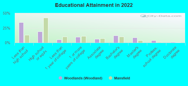
Education in this neighborhood (subdivision or community):
- Percentage of people 3 years and older in K-12 schools:
Woodlands (Woodland): 17.0% Mansfield: 14.3%
- Percentage of people 3 years and older in undergraduate colleges:
Woodlands (Woodland): 4.5% Mansfield: 6.0%
- Percentage of people 3 years and older in grad. or professional schools:
Woodlands (Woodland): 2.2% Mansfield: 0.8%
- Percentage of students K-12 enrolled in private schools:
Woodlands (Woodland): 70.4% Mansfield: 14.1%
Percentage of population below poverty level:
| Woodlands (Woodland): | 7.8% |
| Mansfield: | 25.0% |
Median year renter moved in (as recorded in 2022):
| Woodlands (Woodland): | 2015 |
| Mansfield: | 2016 |
Percentage of married-couple families with both working:
| Woodlands (Woodland): | 88.4% |
| Mansfield: | 69.3% |
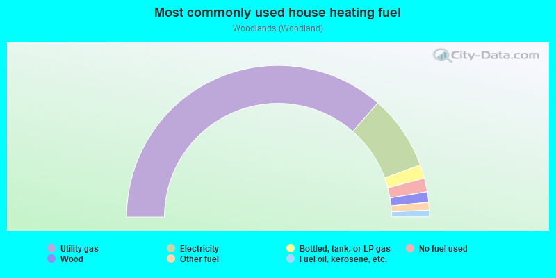
- 72.9%Utility gas
- 16.0%Electricity
- 2.9%Bottled, tank, or LP gas
- 2.9%No fuel used
- 2.2%Wood
- 1.7%Other fuel
- 1.4%Fuel oil, kerosene, etc.
Highways in this neighborhood:
US Rte 42 S (Lexington Ave, US Rte 42)
Length: 1.74 miles
Direction: SW-NE
Address range: 255 to 1139
Direction: SW-NE
Address range: 255 to 1139
Roads and streets:
S Trimble Rd
Length: 1.37 miles
Directions: N-S, SE-NW
Address range: 760 to 1366
Directions: N-S, SE-NW
Address range: 760 to 1366
Woodland Rd
Length: 1.34 miles
Directions: E-W, N-S, SE-NW
Address range: 501 to 1204
Directions: E-W, N-S, SE-NW
Address range: 501 to 1204
Woodhill Rd
Length: 1.24 miles
Directions: E-W, N-S, SE-NW
Address range: 453 to 1084
Directions: E-W, N-S, SE-NW
Address range: 453 to 1084
Cline Ave
Length: 1.13 miles
Direction: E-W
Address range: 183 to 632
Direction: E-W
Address range: 183 to 632
W Cook Rd
Length: 1.07 miles
Directions: E-W, SW-NE
Address range: 492 to 999
Directions: E-W, SW-NE
Address range: 492 to 999
Marion Ave (Marion Avenue Rd)
Length: 1.05 miles
Directions: E-W, SW-NE
Address range: 700 to 1099
Directions: E-W, SW-NE
Address range: 700 to 1099
Edgewood Rd
Length: 0.92 miles
Directions: E-W, N-S, SE-NW, SW-NE
Address range: 351 to 682
Directions: E-W, N-S, SE-NW, SW-NE
Address range: 351 to 682
Overlook Rd
Length: 0.90 miles
Directions: E-W, N-S, SE-NW
Address range: 354 to 699
Directions: E-W, N-S, SE-NW
Address range: 354 to 699
Millsboro East Rd (Millsboro Rd)
Length: 0.85 miles
Direction: E-W
Address range: 629 to 913
Direction: E-W
Address range: 629 to 913
Stewart Ln
Length: 0.76 miles
Directions: E-W, SE-NW, SW-NE
Address range: 400 to 701
Directions: E-W, SE-NW, SW-NE
Address range: 400 to 701
Dickson Pkwy
Length: 0.73 miles
Directions: N-S, SE-NW, SW-NE
Address range: 471 to 999
Directions: N-S, SE-NW, SW-NE
Address range: 471 to 999
Davis Rd
Length: 0.67 miles
Directions: E-W, SW-NE
Address range: 221 to 527
Directions: E-W, SW-NE
Address range: 221 to 527
Yale Dr
Length: 0.64 miles
Directions: E-W, SW-NE
Address range: 525 to 853
Directions: E-W, SW-NE
Address range: 525 to 853
Glendale Blvd
Length: 0.57 miles
Directions: E-W, SE-NW
Address range: 600 to 899
Directions: E-W, SE-NW
Address range: 600 to 899
Courtwright Blvd
Length: 0.53 miles
Directions: E-W, SE-NW
Address range: 600 to 772
Directions: E-W, SE-NW
Address range: 600 to 772
Chevy Chase Rd
Length: 0.53 miles
Direction: E-W
Address range: 393 to 599
Direction: E-W
Address range: 393 to 599
Westview Blvd
Length: 0.53 miles
Directions: E-W, SE-NW
Address range: 540 to 743
Directions: E-W, SE-NW
Address range: 540 to 743
Clifton Blvd
Length: 0.52 miles
Directions: E-W, SE-NW
Address range: 580 to 799
Directions: E-W, SE-NW
Address range: 580 to 799
Forest Hill Rd
Length: 0.51 miles
Direction: E-W
Address range: 460 to 651
Direction: E-W
Address range: 460 to 651
S Andover Rd
Length: 0.49 miles
Directions: E-W, N-S, SW-NE
Address range: 600 to 899
Directions: E-W, N-S, SW-NE
Address range: 600 to 899
Shepard Rd
Length: 0.49 miles
Directions: E-W, SE-NW, SW-NE
Address range: 345 to 530
Directions: E-W, SE-NW, SW-NE
Address range: 345 to 530
Russell Rd
Length: 0.48 miles
Directions: E-W, N-S, SE-NW
Address range: 478 to 699
Directions: E-W, N-S, SE-NW
Address range: 478 to 699
Crescent Rd
Length: 0.46 miles
Directions: E-W, N-S, SW-NE
Address range: 453 to 627
Directions: E-W, N-S, SW-NE
Address range: 453 to 627
Ruth Ave
Length: 0.45 miles
Direction: E-W
Address range: 218 to 399
Direction: E-W
Address range: 218 to 399
Abbeyfeale Rd
Length: 0.42 miles
Directions: E-W, SE-NW
Address range: 200 to 499
Directions: E-W, SE-NW
Address range: 200 to 499
Bigelow Rd
Length: 0.38 miles
Direction: E-W
Address range: 474 to 651
Direction: E-W
Address range: 474 to 651
Sunset Blvd
Length: 0.36 miles
Directions: E-W, SW-NE
Address range: 685 to 803
Directions: E-W, SW-NE
Address range: 685 to 803
Brae Burn Rd
Length: 0.36 miles
Direction: E-W
Address range: 555 to 701
Direction: E-W
Address range: 555 to 701
W Andover Rd
Length: 0.35 miles
Direction: E-W
Address range: 553 to 899
Direction: E-W
Address range: 553 to 899
Broadview Ave
Length: 0.33 miles
Direction: E-W
Address range: 438 to 566
Direction: E-W
Address range: 438 to 566
Austin Rd
Length: 0.33 miles
Direction: E-W
Address range: 520 to 632
Direction: E-W
Address range: 520 to 632
Chapelwood Blvd
Length: 0.30 miles
Directions: N-S, SE-NW
Address range: 1800 to 1899
Directions: N-S, SE-NW
Address range: 1800 to 1899
Midland Dr
Length: 0.27 miles
Direction: E-W
Address range: 436 to 529
Direction: E-W
Address range: 436 to 529
S Davis Rd
Length: 0.27 miles
Directions: N-S, SW-NE
Address range: 599 to 721
Directions: N-S, SW-NE
Address range: 599 to 721
Hawthorn Ln
Length: 0.25 miles
Direction: E-W
Address range: 555 to 644
Direction: E-W
Address range: 555 to 644
Wood St
Length: 0.25 miles
Directions: N-S, SE-NW, SW-NE
Address range: 405 to 599
Directions: N-S, SE-NW, SW-NE
Address range: 405 to 599
Gadfield Rd
Length: 0.24 miles
Directions: N-S, SE-NW
Address range: 430 to 564
Directions: N-S, SE-NW
Address range: 430 to 564
N Townview Cir
Length: 0.22 miles
Direction: E-W
Address range: 290 to 399
Direction: E-W
Address range: 290 to 399
Bowland Rd
Length: 0.21 miles
Directions: E-W, SW-NE
Address range: 180 to 270
Directions: E-W, SW-NE
Address range: 180 to 270
Lexdale Ln
Length: 0.20 miles
Directions: E-W, N-S, SE-NW, SW-NE
Address range: 879 to 965
Directions: E-W, N-S, SE-NW, SW-NE
Address range: 879 to 965
Saxton Rd
Length: 0.19 miles
Directions: E-W, N-S, SW-NE
Address range: 176 to 276
Directions: E-W, N-S, SW-NE
Address range: 176 to 276
E Townview Cir
Length: 0.19 miles
Directions: N-S, SE-NW, SW-NE
Address range: 396 to 579
Directions: N-S, SE-NW, SW-NE
Address range: 396 to 579
Cunning Dr
Length: 0.17 miles
Directions: N-S, SW-NE
Address range: 1838 to 1899
Directions: N-S, SW-NE
Address range: 1838 to 1899
Bally Row
Length: 0.14 miles
Direction: N-S
Address range: 600 to 698
Direction: N-S
Address range: 600 to 698
W Townview Cir
Length: 0.14 miles
Directions: N-S, SW-NE
Address range: 494 to 566
Directions: N-S, SW-NE
Address range: 494 to 566
Autumn Dr
Length: 0.14 miles
Directions: N-S, SE-NW
Address range: 1848 to 1899
Directions: N-S, SE-NW
Address range: 1848 to 1899
Bartley Ave
Length: 0.14 miles
Direction: N-S
Address range: 401 to 473
Direction: N-S
Address range: 401 to 473
Sturges Ave
Length: 0.13 miles
Direction: N-S
Address range: 409 to 478
Direction: N-S
Address range: 409 to 478
Lexbrook Trl
Length: 0.12 miles
Directions: E-W, SE-NW
Address range: 889 to 1011
Directions: E-W, SE-NW
Address range: 889 to 1011
Bertram Ave
Length: 0.10 miles
Direction: N-S
Address range: 429 to 464
Direction: N-S
Address range: 429 to 464
Hedeen Dr
Length: 0.10 miles
Direction: N-S
Address range: 400 to 473
Direction: N-S
Address range: 400 to 473
Meadow Ln
Length: 0.09 miles
Direction: E-W
Address range: 600 to 799
Direction: E-W
Address range: 600 to 799
Locust Ln
Length: 0.08 miles
Direction: SW-NE
Address range: 748 to 754
Direction: SW-NE
Address range: 748 to 754
W Davis Rd
Length: 0.08 miles
Direction: E-W
Direction: E-W
Gerald Ave
Length: 0.06 miles
Directions: N-S, SE-NW
Address range: 433 to 462
Directions: N-S, SE-NW
Address range: 433 to 462
Pine Ln
Length: 0.05 miles
Direction: SW-NE
Direction: SW-NE
Balgreen Dr
Length: 0.04 miles
Direction: N-S
Address range: 700 to 798
Direction: N-S
Address range: 700 to 798
Berlyn Ct
Length: 0.04 miles
Direction: N-S
Address range: 433 to 463
Direction: N-S
Address range: 433 to 463