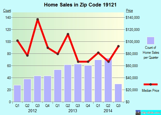
Property valuation of N 32nd Street, Philadelphia, PA: 2024, 2025, 2026, 2027, 2028, 2029, 2030, 2031, 2032, 2033 (tax assessments)
Other nearby streets: Fontain Street (1)  Fontain Street (2)
Fontain Street (3)
N 32nd Street (1)
N 32nd Street (2)
Fontain Street (2)
Fontain Street (3)
N 32nd Street (1)
N 32nd Street (2)
Fontain Street (2)
Fontain Street (3)
N 32nd Street (1)
N 32nd Street (2)
Listed properties vs overall distribution of properties in Philadelphia, PA:
Advertisements
2024 N 32nd Street
Philadelphia, PA 19121
Find on map >>
Owner: WILLIAM PLANT JR ET AL
Assessed land value: $5,728 (it was $96 in 2009)
Assessed building value: $14,172 (it was $640 in 2009)
Total assessed value for property: $19,900 (it was $736 in 2009)
Market value: $19,900
Date of last market value change: 01/2013
Sale price: $5,000
Date the deed was transferred: 02/22/1984
Status of construction: Finished
Category: Residential
Frontage: 16.25 feet
Depth: 78.32 feet
Shape: Rectangular
Topography: Street level
Garage type: None
View: Typical
Number of stories: 3
Date the exterior condition was observed: 03/04/2010
Exterior condition: Sealed
Year property was built: 1925 (estimated)
Connection to sewer: Yes
Land area: 1,272.85 square feet
Total dwelling livable area: 2,100 square feet
Assessments for tax year: 2014
2025 N 32nd Street
Philadelphia, PA 19121
Find on map >>
Owner: VERNON L JACKSON
Assessed land value: $4,436 (it was $645 in 2009)
Assessed building value: $62,964 (it was $1,787 in 2009)
Total assessed value for property: $67,400 (it was $2,432 in 2009)
Market value: $67,400
Date of last market value change: 01/2013
Sale price: $1
Date the deed was transferred: 03/26/2008
Sale type: Sale deferred for closer review by Evaluation staff
Status of construction: Finished
Category: Hotels and Apartments
Frontage: 14.33 feet
Depth: 76 feet
Shape: Rectangular
Topography: Street level
Garage type: None
View: Typical
Number of stories: 2
Date the exterior condition was observed: 05/04/2012
Exterior condition: Rehabilitated
Year property was built: 1925 (estimated)
Number of rooms: 6
Number of bedrooms: 3
Number of bathrooms: 1
Connection to sewer: Yes
Land area: 1,089.07 square feet
Total dwelling livable area: 1,140 square feet
Assessments for tax year: 2014
2026 N 32nd Street
Philadelphia, PA 19121
Find on map >>
Owner: DEVELOPMENT COMPA FRIENDS
Total assessed value for property: $0
Market value: $67,500
Date of last market value change: 01/2013
Sale price: $1,484,942
Date the deed was transferred: 08/03/2012
Sale type: Deed of subdivision or consolidation or containing multiple properties or assemblage
Status of construction: Finished
Category: Hotels and Apartments
Frontage: 16.25 feet
Depth: 78.32 feet
Shape: Rectangular
Topography: Street level
Garage type: None
View: Typical
Number of stories: 3
Date the exterior condition was observed: 02/19/1914
Exterior condition: Average
Year property was built: 1915 (estimated)
Floor plan: Triplex (converted)
Connection to sewer: Yes
Land area: 1,272.85 square feet
Total dwelling livable area: 2,100 square feet
Assessments for tax year: 2014
2027 N 32nd Street
Philadelphia, PA 19121
Find on map >>
Owner: BOBBY LANGLEY
Assessed land value: $4,683 (it was $341 in 2009)
Assessed building value: $12,217 (it was $683 in 2009)
Total assessed value for property: $16,900 (it was $1,024 in 2009)
Market value: $16,900
Date of last market value change: 01/2013
Sale price: $25,000
Date the deed was transferred: 10/18/2005
Sale type: Sale deferred for closer review by Evaluation staff
Status of construction: Finished
Category: Residential
Site type: Inside location on the block
Frontage: 14.33 feet
Depth: 76 feet
Shape: Rectangular
Topography: Street level
Garage type: None
View: Typical
Number of stories: 2
Date the exterior condition was observed: 05/04/2012
Exterior condition: Below average
Year property was built: 1925 (estimated)
Number of rooms: 6
Number of bedrooms: 3
Number of bathrooms: 1
Connection to sewer: Yes
Separation of utilities: Central (one heater, hot water tank, electrical service and gas service)
Land area: 1,089.07 square feet
Total dwelling livable area: 1,140 square feet
Assessments for tax year: 2014
2028 N 32nd Street
Philadelphia, PA 19121
Find on map >>
Owner: JOHNSON M MARTHA RICHARD
Assessed land value: $5,728 (it was $435 in 2009)
Assessed building value: $14,172 (it was $2,893 in 2009)
Total assessed value for property: $19,900 (it was $3,328 in 2009)
Market value: $19,900
Date of last market value change: 01/2013
Sale price: $1
Date the deed was transferred: 01/14/1958
Status of construction: Finished
Category: Residential
Frontage: 16.25 feet
Depth: 78.32 feet
Shape: Rectangular
Topography: Street level
Garage type: None
View: Typical
Number of stories: 3
Date the exterior condition was observed: 02/23/2010
Exterior condition: Sealed
Year property was built: 1915
Connection to sewer: Yes
Land area: 1,272.85 square feet
Total dwelling livable area: 2,100 square feet
Assessments for tax year: 2014
2029 N 32nd Street
Philadelphia, PA 19121
Find on map >>
Owner: KYMMBERLI STOWE
Assessed land value: $4,627 (it was $101 in 2009)
Assessed building value: $8,973 (it was $283 in 2009)
Total assessed value for property: $13,600 (it was $384 in 2009)
Market value: $13,600
Date of last market value change: 01/2013
Sale price: $1
Date the deed was transferred: 11/08/2005
Sale type: Sales between related parties, i.e. Grantor/Grantee, Owner/Tenant
Status of construction: Finished
Category: Residential
Site type: Inside location on the block
Frontage: 14.16 feet
Depth: 76 feet
Shape: Rectangular
Topography: Street level
Garage type: None
View: Typical
Number of stories: 2
Date the exterior condition was observed: 03/04/2010
Exterior condition: Sealed
Year property was built: 1925 (estimated)
Number of rooms: 6
Number of bedrooms: 3
Number of bathrooms: 1
Connection to sewer: Yes
Land area: 1,076.16 square feet
Total dwelling livable area: 1,140 square feet
Assessments for tax year: 2014
2030 N 32nd Street
Philadelphia, PA 19121
Find on map >>
Owner: RODNEY ERIC SAMUELS
Assessed land value: $5,728 (it was $334 in 2009)
Assessed building value: $15,272 (it was $2,226 in 2009)
Total assessed value for property: $21,000 (it was $2,560 in 2009)
Market value: $21,000
Date of last market value change: 01/2013
Sale price: $1
Date the deed was transferred: 04/30/1996
Sale type: Sales between related parties, i.e. Grantor/Grantee, Owner/Tenant
Status of construction: Finished
Category: Residential
Frontage: 16.25 feet
Depth: 78.32 feet
Shape: Rectangular
Topography: Street level
Garage type: None
View: Typical
Number of stories: 3
Date the exterior condition was observed: 02/23/2010
Exterior condition: Sealed
Year property was built: 1915
Connection to sewer: Yes
Land area: 1,272.85 square feet
Total dwelling livable area: 2,280 square feet
Assessments for tax year: 2014
2031 N 32nd Street
Philadelphia, PA 19121
Find on map >>
Owner: JAMES O FORD
Assessed land value: $4,683 (it was $442 in 2009)
Assessed building value: $12,217 (it was $1,222 in 2009)
Total assessed value for property: $16,900 (it was $1,664 in 2009)
Market value: $16,900
Date of last market value change: 01/2013
Sale price: $6,000
Date the deed was transferred: 07/06/1984
Status of construction: Finished
Category: Residential
Frontage: 14.33 feet
Depth: 76 feet
Shape: Rectangular
Topography: Street level
Garage type: None
View: Typical
Number of stories: 2
Date the exterior condition was observed: 02/07/2001
Exterior condition: Below average
Year property was built: 1925 (estimated)
Number of rooms: 6
Number of bedrooms: 3
Number of bathrooms: 1
Connection to sewer: Yes
Land area: 1,089.07 square feet
Total dwelling livable area: 1,140 square feet
Assessments for tax year: 2014
2032 N 32nd Street
Philadelphia, PA 19121
Find on map >>
Owner: REDEVELOPMENT AUTHORITY OF PHILA
Total assessed value for property: $0
Market value: $5,200
Date of last market value change: 01/2013
Sale price: $1
Date the deed was transferred: 07/12/2006
Sale type: Forced, Sheriff, Bankruptcy or Court-ordered Sales, Condemnation, Deed in lieu of Condemnation
Status of construction: Finished
Category: Vacant Land
Frontage: 16.50 feet
Depth: 78.32 feet
Shape: Rectangular
Topography: Street level
Garage type: None
View: Typical
Connection to sewer: Yes
Land area: 1,292.44 square feet
Assessments for tax year: 2014
2033 N 32nd Street
Philadelphia, PA 19121
Find on map >>
Owner: ROBERT LEE HATTIE LIGHTY
Assessed land value: $4,683 (it was $645 in 2009)
Assessed building value: $18,717 (it was $1,787 in 2009)
Total assessed value for property: $23,400 (it was $2,432 in 2009)
Market value: $23,400
Date of last market value change: 01/2013
Sale price: $6,600
Date the deed was transferred: 08/06/1982
Sale type: No Commonwealth of PA/City of Philadelphia Transfer Tax Indication
Status of construction: Finished
Category: Residential
Frontage: 14.33 feet
Depth: 76 feet
Shape: Rectangular
Topography: Street level
Garage type: None
View: Typical
Number of stories: 2
Date the exterior condition was observed: 05/04/2012
Exterior condition: Average
Year property was built: 1925 (estimated)
Number of rooms: 6
Number of bedrooms: 3
Number of bathrooms: 1
Connection to sewer: Yes
Land area: 1,089.07 square feet
Total dwelling livable area: 1,140 square feet
Assessments for tax year: 2014
Other nearby streets: Fontain Street (1)
Fontain Street (2)
Fontain Street (3)
N 32nd Street (1)
N 32nd Street (2)
Fontain Street (2)
Fontain Street (3)
N 32nd Street (1)
N 32nd Street (2)

Recent posts about Philadelphia, Pennsylvania on our local forum with over 2,400,000 registered users. Philadelphia is mentioned 39,615 times on our forum:

Settings
X

Recently Added Photos

Philadelphia, PA
Philadelphia, PA

Philadelphia, PA

Philadelphia, PA

Philadelphia, PA
Philadelphia, PA

Philadelphia, PA
Philadelphia, PA

Philadelphia, PA

Philadelphia, PA

Philadelphia, PA

Philadelphia, PA
Request disassociating your name from street-level assessment address

Recent home sales, price trends, and home value evaluator powered by Onboard Informatics
© 2024 Onboard Informatics. Information is deemed reliable but not guaranteed.
© 2024 Onboard Informatics. Information is deemed reliable but not guaranteed.
Some parts © 2024 Advameg, Inc.
Compilation, repackaging, or reproduction prohibited. Users are forewarned that it is incumbent upon them to verify information with the responsible state agency. Advameg, Inc. does not guarantee the data presented is up-to-date nor does it assume responsibility for updating it. Therefore any names, owners or addresses may have changed. Use of any information published here to contact the persons might be prohibited by the law.