
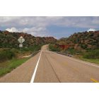
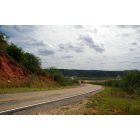
Turkey, TX: STATE HIGHWAY 70 BRIDGES the Prairie Dog Town Fork Red River north of Turkey.
Rate this picture:
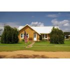
![Turkey: : ATTRACTIVE BRICK HOME dating from the mid-20th century near State Highway 70.]()
Turkey: ATTRACTIVE BRICK HOME dating from the mid-20th century near State Highway 70.
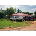
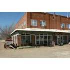
![Turkey: : WORKING HOUSEHOLD surrounded by working trucks. Turkey is situated at the intersection of State Highways 86 and 70, on the Burlington Northern line in the southwestern corner of Hall County.]()
Turkey: WORKING HOUSEHOLD surrounded by working trucks. Turkey is situated at the intersection of State Highways 86 and 70, on the Burlington Northern line in the southwestern corner of Hall County.
![Turkey: : PRAIRIE DOG TOWN FORK RED RIVER begins when two creeks merge in the Palo Duro Canyon, the nation's second largest. Fed by springs there that form its base flow, runoff from rainstorms occurring along the Llano Estacado mesa's escarpment can dramatically increase its volume.]()
Turkey: PRAIRIE DOG TOWN FORK RED RIVER begins when two creeks merge in the Palo Duro Canyon, the nation's second largest. Fed by springs there that form its base flow, runoff from rainstorms occurring along the Llano Estacado mesa's escarpment can dramatically increase its volume.
![Turkey: : STATE HIGHWAY 70 BRIDGES the Prairie Dog Town Fork Red River north of Turkey.]()
![Turkey: : PRAIRIE DOG TOWN FORK RED RIVER, just north of Turkey, is the largest tributary of the Red River, which in turn comprises most of the east-west border between Oklahoma and Texas on its way to the Mississippi and Atchafalaya Rivers.]()
Turkey: PRAIRIE DOG TOWN FORK RED RIVER, just north of Turkey, is the largest tributary of the Red River, which in turn comprises most of the east-west border between Oklahoma and Texas on its way to the Mississippi and Atchafalaya Rivers.
![Turkey: : Hotel]()
Turkey: Hotel
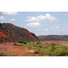
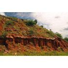
![Turkey: : VISIBLE STRATA along Prairie Dog Town Fork Red River were deposited during the Permian and Triassic periods when the area was a sea. Consisting mostly of unconsolidated, deep-red, slightly calcareous shaly clay, these Permian "Red Beds" contain a rather high content of sodium chloride and other salts.]()
Turkey: VISIBLE STRATA along Prairie Dog Town Fork Red River were deposited during the Permian and Triassic periods when the area was a sea. Consisting mostly of unconsolidated, deep-red, slightly calcareous shaly clay, these Permian "Red Beds" contain a rather high content of sodium chloride and other salts.
![Turkey: : Turkey Hotel Bed & Breakfast]()
Turkey: Turkey Hotel Bed & Breakfast
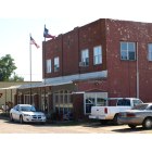
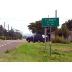
![Turkey: : CITY LIMITS. Settled in the early 1890S, the town was first called Turkey Roost for the wild turkey roosts found on nearby Turkey Creek. The name was changed in 1893.]()
Turkey: CITY LIMITS. Settled in the early 1890S, the town was first called Turkey Roost for the wild turkey roosts found on nearby Turkey Creek. The name was changed in 1893.
- see
12
more - add
your
Report an error or a problem with this picture
Upload your own Turkey, TX photo and show it to the world!- Viewed
- 1676 times
- Current avarege rating
- 8.6 (8 votes)
- Picture by
- TJ Pierce
- Submitted on
- 3/21/2013