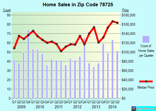
Property valuation of Platt Lane, Austin, TX (tax assessments)
Other nearby streets: Garden Gate Drive  Garden Grove Drive
Harold Green Road
Platt Lane (1)
Platt Lane (2)
Garden Grove Drive
Harold Green Road
Platt Lane (1)
Platt Lane (2)
Garden Grove Drive
Harold Green Road
Platt Lane (1)
Platt Lane (2)
Listed properties vs overall distribution of properties in Austin, TX:
Advertisements
Platt Lane
Austin, TX 78725
Find on map >>
Owner: OPERATIONS L P TXI
Property type: Real
Property tax division code: D2 - Acreage (Non-Ag)
Appraisal or Tax Year: 2013
Total market land value: $4,697
Total market value for property: $4,697 (it was $4,697 in 2009)
Land size: 83,505 square feet
Austin, TX 78725
Find on map >>
Owner: OPERATIONS L P TXI
Property type: Real
Property tax division code: D2 - Acreage (Non-Ag)
Appraisal or Tax Year: 2013
Total market land value: $4,697
Total market value for property: $4,697 (it was $4,697 in 2009)
Land size: 83,505 square feet
Platt Lane
Austin, TX 78725
Find on map >>
Owner: OPERATIONS L P TXI
Property type: Real
Property tax division code: D2 - Acreage (Non-Ag)
Appraisal or Tax Year: 2013
Total market land value: $41,606
Total market value for property: $41,606 (it was $41,606 in 2009)
Land size: 739,736 square feet
Austin, TX 78725
Find on map >>
Owner: OPERATIONS L P TXI
Property type: Real
Property tax division code: D2 - Acreage (Non-Ag)
Appraisal or Tax Year: 2013
Total market land value: $41,606
Total market value for property: $41,606 (it was $41,606 in 2009)
Land size: 739,736 square feet
Platt Lane
Austin, TX 78725
Find on map >>
Owner: CITY OF AUSTIN & REAL ESTATE DIVISION
Property type: Real
Property tax division code: A1 - Single Family Residence
Appraisal or Tax Year: 2013
Total market land value: $991,859
Total market building value: $63,943 (it was $1,106,340 in 2009)
Total market value for property: $1,055,802 (it was $1,106,340 in 2009)
Land size: 14,695,707 square feet
Property improvements: 1st floor, Barn fv, Bathroom, Fireplace, Heating ventilation and air conditioning residential, Obs fence, Porch open 1st floor, Storage detached
Roof Style: Gable
Roof Covering: Metal
Foundation: Pier And Beam
Platt Lane
Austin, TX 78725
Find on map >>
Owner: CITY OF AUSTIN
Property type: Real
Property tax division code: A1 - Single Family Residence
Appraisal or Tax Year: 2013
Total market land value: $549,900
Total market building value: $64,655 (it was $620,994 in 2009)
Total market value for property: $614,555 (it was $620,994 in 2009)
Land size: 2,395,364 square feet
Property improvements: 1st floor, Bathroom, Fireplace, Garage detached 1st floor, Porch open 1st floor, Storage detached, Water/sewer inf
Platt Lane
Austin, TX 78725
Find on map >>
Owner: CITY OF AUSTIN
Property type: Real
Property tax division code: D2 - Acreage (Non-Ag)
Appraisal or Tax Year: 2013
Total market land value: $548,700
Total market value for property: $548,700 (it was $548,700 in 2009)
Land size: 2,390,137 square feet
Austin, TX 78725
Find on map >>
Owner: CITY OF AUSTIN
Property type: Real
Property tax division code: D2 - Acreage (Non-Ag)
Appraisal or Tax Year: 2013
Total market land value: $548,700
Total market value for property: $548,700 (it was $548,700 in 2009)
Land size: 2,390,137 square feet
Platt Lane
Austin, TX 78725
Find on map >>
Owner: CITY OF AUSTIN
Property type: Real
Property tax division code: D2 - Acreage (Non-Ag)
Appraisal or Tax Year: 2013
Total market land value: $177,600
Total market value for property: $177,600 (it was $177,600 in 2009)
Land size: 773,626 square feet
Austin, TX 78725
Find on map >>
Owner: CITY OF AUSTIN
Property type: Real
Property tax division code: D2 - Acreage (Non-Ag)
Appraisal or Tax Year: 2013
Total market land value: $177,600
Total market value for property: $177,600 (it was $177,600 in 2009)
Land size: 773,626 square feet
Platt Lane
Austin, TX 78725
Find on map >>
Owner: CITY OF AUSTIN
Property type: Real
Property tax division code: D2 - Acreage (Non-Ag)
Appraisal or Tax Year: 2013
Total market land value: $215,481
Total market value for property: $215,481 (it was $215,481 in 2009)
Land size: 1,632,411 square feet
Austin, TX 78725
Find on map >>
Owner: CITY OF AUSTIN
Property type: Real
Property tax division code: D2 - Acreage (Non-Ag)
Appraisal or Tax Year: 2013
Total market land value: $215,481
Total market value for property: $215,481 (it was $215,481 in 2009)
Land size: 1,632,411 square feet
Platt Lane
Austin, TX 78725
Find on map >>
Owner: SHUMAKER ENTERPRISES INC
Appraisal or Tax Year: 2013
Total market land value: $283,534
Total market value for property: $283,534
Austin, TX 78725
Find on map >>
Owner: SHUMAKER ENTERPRISES INC
Appraisal or Tax Year: 2013
Total market land value: $283,534
Total market value for property: $283,534
Platt Lane
Austin, TX 78725
Find on map >>
Owner: SHUMAKER ENTERPRISES INC
Property type: Real
Property tax division code: F1 - Commercial
Appraisal or Tax Year: 2009
Total market land value: $10,290
Total market building value: $416,126
Total market value for property: $426,416
Land size: 152,460 square feet
Property improvements: 1st floor, Bathroom, Heating ventilation and air conditioning residential, Porch open 1st floor, Sketch only, Storage detached, Terrace
Roof Style: Gable
Roof Covering: Metal
Foundation: Slab
Platt Lane
Austin, TX 78725
Find on map >>
Owner: SINCLAIR TELECABLE INC FOR THE
Property type: Real
Property tax division code: F1 - Commercial
Appraisal or Tax Year: 2013
Total market land value: $242,276
Total market building value: $43,646 (it was $242,276 in 2009)
Total market value for property: $285,922 (it was $242,276 in 2009)
Land size: 1,835,401 square feet
Other nearby streets: Garden Gate Drive
Garden Grove Drive
Harold Green Road
Platt Lane (1)
Platt Lane (2)
Garden Grove Drive
Harold Green Road
Platt Lane (1)
Platt Lane (2)

Recent posts about Austin, Texas on our local forum with over 2,400,000 registered users. Austin is mentioned 145,874 times on our forum:
 | Why tech talent is in the process of abandoning Austin (34 replies) |
| Austin Trip Reflection (30 replies) |
| Let’s be honest. What’s your take on Austin and newcomers? (42 replies) |
| How much longer does Austin have? (338 replies) |
| UT Austin Policy Report Shows Austin's the Only Fast-Growing City Losing African-Americans (150 replies) |
| Latest crime statistics for Austin, 2016 (2 replies) |
Settings
X

Recently Added Photos

Austin, TX

Austin, TX

Austin, TX
Austin, TX
Austin, TX
Austin, TX
Austin, TX
Austin, TX

Austin, TX

Austin, TX

Austin, TX

Austin, TX
Request disassociating your name from street-level assessment address

Recent home sales, price trends, and home value evaluator powered by Onboard Informatics
© 2024 Onboard Informatics. Information is deemed reliable but not guaranteed.
© 2024 Onboard Informatics. Information is deemed reliable but not guaranteed.
Some parts © 2024 Advameg, Inc.
Compilation, repackaging, or reproduction prohibited. Users are forewarned that it is incumbent upon them to verify information with the responsible state agency. Advameg, Inc. does not guarantee the data presented is up-to-date nor does it assume responsibility for updating it. Therefore any names, owners or addresses may have changed. Use of any information published here to contact the persons might be prohibited by the law.