Bridge Statistics for Bluford, Illinois (IL)
Condition, Traffic, Stress, Structural Evaluation, Project Costs
- National Bridge Inventory (NBI) Statistics
- 19Number of bridges
- 112ft / 33.6mTotal length
- $372,000Total costs
- 13,560Total average daily traffic
- 1,390Total average daily truck traffic
- National Bridge Inventory (NBI) Registered Bridges for Bluford
- No street view available for this location
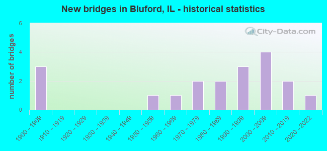
- New bridges - historical statistics
- 31900-1909
- 11950-1959
- 11960-1969
- 21970-1979
- 21980-1989
- 31990-1999
- 42000-2009
- 22010-2019
- 12020-2022


- Bridge Condition - Deck
- 7.7%Excellent
- 30.8%Very good
- 30.8%Good
- 23.1%Satisfactory
- 7.7%Fair

- Bridge Condition - Superstructure
- 7.7%Excellent
- 38.5%Very good
- 7.7%Good
- 23.1%Satisfactory
- 23.1%Fair

- Bridge Condition - Substructure
- 7.7%Excellent
- 46.2%Very good
- 15.4%Good
- 23.1%Satisfactory
- 7.7%Fair

- Bridge Condition - Channel
- 8.3%Excellent
- 16.7%Very good
- 33.3%Good
- 33.3%Satisfactory
- 8.3%Fair

- Bridge Condition - Culverts
- 66.7%Very good
- 33.3%Good
Find on map >> Show street view
Structure Number: 410028, Location: 1 MI W MARKAM CITY (Lat: 38.343189, Lng: -88.740853), Route carried "on" structure: State highway 15, Year Built: 1957, Status: Open, Structure Length: 1.43m (4.69ft), Average Daily Traffic: 3,400 (year 2021), Truck Traffic: 9%, Average Future Daily Traffic: 4,199 (year 2032), Design Load: HS 20, Features Intersected: BEAR CREEK
Minimum Vertical Clearance: 30+ m (98+ ft), Kilometerpoint: 141.506, Lanes on structure: 2, Base Highway Network: Yes, Owner: State Highway Agency, Approaching Roadway Width: 9.8m (32.2ft), Material/Design: Concrete continuous, Design/Construction: Slab, Number Of Spans In Main Unit: 2, Length of Maximum Span: 7.0m (23.0ft), Curb-To-Curb Width: 12.6m (41.3ft), Out-to-Out Width: 13.8m (45.3ft)
Condition: Deck: Good, Superstructure: Fair, Substructure: Satisfactory, Channel: Good, Operating Rating: 48.3 metric tons, Method Used To Determine Operating Rating: Load Factor (LF) rating reported by rating factor (RF) method using MS18 loading, Inventory Rating: 28.8 metric tons, Method Used To Determine Inventory Rating: Load Factor (LF) rating reported by rating factor (RF) method using MS18 loading, Structural Evaluation: Somewhat better than minimum adequacy, Deck Geometry: Equal to present minimum criteria, Waterway Adequacy: Equal to present desirable criteria, Approach Roadway Alignment: Equal to present desirable criteria, Designated Inspection Frequency: Every 24 months, Inspection Date: March 2021, Deck Structure Type: Concrete Cast-file-Place, Wearing Surface/Protective System: Wearing Surface: Integral Concrete
Find on map >> Show street view
Structure Number: 410102, Location: .2 MI W BLUFORD RD (Lat: 38.342753, Lng: -88.727019), Route carried "on" structure: State highway 15, Year Built: 1995, Status: Open, Structure Length: 1.21m (3.97ft), Average Daily Traffic: 3,400 (year 2021), Truck Traffic: 9%, Average Future Daily Traffic: 4,199 (year 2032), Design Load: HS 20, Features Intersected: IC RR
Minimum Vertical Clearance: 30+ m (98+ ft), Kilometerpoint: 142.713, Lanes on structure: 2, Base Highway Network: Yes, Owner: State Highway Agency, Approaching Roadway Width: 9.8m (32.2ft), Material/Design: Concrete, Design/Construction: Slab, Number Of Spans In Main Unit: 1, Length of Maximum Span: 11.3m (37.1ft), Curb-To-Curb Width: 11.0m (36.1ft), Out-to-Out Width: 11.9m (39.0ft)
Condition: Deck: Satisfactory, Superstructure: Satisfactory, Substructure: Satisfactory, Operating Rating: 69.7 metric tons, Method Used To Determine Operating Rating: Load Factor (LF) rating reported by rating factor (RF) method using MS18 loading, Inventory Rating: 41.8 metric tons, Method Used To Determine Inventory Rating: Load Factor (LF) rating reported by rating factor (RF) method using MS18 loading, Structural Evaluation: Equal to present minimum criteria, Deck Geometry: Somewhat better than minimum adequacy, Underclear: Equal to present desirable criteria, Approach Roadway Alignment: Equal to present desirable criteria, Designated Inspection Frequency: Every 24 months, Inspection Date: Febuary 2021, Deck Structure Type: Concrete Cast-file-Place, Wearing Surface/Protective System: Deck Protection: Epoxy Coated Reinforcing
Find on map >> Show street view
Structure Number: 412014, Location: .5 MI W MARKAM CITY (Lat: 38.342950, Lng: -88.733825), Route carried "on" structure: State highway 15, Year Built: 1993, Status: Open, Structure Length: 0.93m (3.05ft), Average Daily Traffic: 3,400 (year 2021), Truck Traffic: 9%, Average Future Daily Traffic: 4,199 (year 2032), Design Load: HS 20, Features Intersected: STREAM
Minimum Vertical Clearance: 30+ m (98+ ft), Kilometerpoint: 142.117, Lanes on structure: 2, Base Highway Network: Yes, Owner: State Highway Agency, Approaching Roadway Width: 9.1m (29.9ft), Skew: 4 degrees, Material/Design: Concrete continuous, Design/Construction: Culvert, Number Of Spans In Main Unit: 2, Length of Maximum Span: 4.5m (14.8ft)
Condition: Channel: Good, Culverts: Very good, Operating Rating: 67.1 metric tons, Method Used To Determine Operating Rating: Load Factor (LF) rating reported by rating factor (RF) method using MS18 loading, Inventory Rating: 40.2 metric tons, Method Used To Determine Inventory Rating: Load Factor (LF) rating reported by rating factor (RF) method using MS18 loading, Structural Evaluation: Equal to present desirable criteria, Waterway Adequacy: Equal to present desirable criteria, Approach Roadway Alignment: Equal to present desirable criteria, Designated Inspection Frequency: Every 48 months, Inspection Date: January 2019
Find on map >> Show street view
Structure Number: 413143, Location: 2.5 MI NNW BLUFORD (Lat: 38.370869, Lng: -88.756139), Route carried "on" structure: County highway , Year Built: 1909, Status: Open, Structure Length: 1.01m (3.31ft), Average Daily Traffic: 100 (year 2021), Truck Traffic: 40%, Average Future Daily Traffic: 111 (year 2032), Features Intersected: PUNCHEON CREEK, Facility Carried by Structure: TR-492
Minimum Vertical Clearance: 30+ m (98+ ft), Kilometerpoint: 2.671, Lanes on structure: 1, Owner: Town or Township Highway Agency, Approaching Roadway Width: 6.7m (22.0ft), Material/Design: Concrete, Number Of Spans In Main Unit: 1, Length of Maximum Span: 9.1m (29.9ft), Curb-To-Curb Width: 5.0m (16.4ft), Out-to-Out Width: 5.8m (19.0ft)
Condition: Deck: Satisfactory, Superstructure: Satisfactory, Substructure: Satisfactory, Channel: Satisfactory, Operating Rating: 40.5 metric tons, Method Used To Determine Operating Rating: Field evaluation and documented engineering judgment, Inventory Rating: 24.3 metric tons, Method Used To Determine Inventory Rating: Field evaluation and documented engineering judgment, Structural Evaluation: Equal to present minimum criteria, Deck Geometry: High priority of corrective action, Waterway Adequacy: Better than present minimum criteria, Approach Roadway Alignment: Equal to present minimum criteria, Length Of Structure Improvement: 1.62m (5.31ft), Designated Inspection Frequency: Every 24 months, Inspection Date: January 2022, Bridge Improvement Cost: $66,000, Roadway Improvement Cost: $7,000, Total Project Cost: $100,000, Deck Structure Type: Concrete Cast-file-Place, Wearing Surface/Protective System: Wearing Surface: Gravel
Find on map >> Show street view
Structure Number: 41316, Location: 1 MI N BLUFORD (Lat: 38.340500, Lng: -88.747244), Route carried "on" structure: County highway , Year Built: 1974, Status: Open, Structure Length: 1.04m (3.41ft), Average Daily Traffic: 1,250 (year 2021), Truck Traffic: 8%, Average Future Daily Traffic: 1,326 (year 2032), Design Load: HS 20, Features Intersected: BEAR CREEK, Facility Carried by Structure: FAS 830 (CH 8)
Minimum Vertical Clearance: 30+ m (98+ ft), Kilometerpoint: 0.306, Lanes on structure: 2, Owner: County Highway Agency, Approaching Roadway Width: 9.1m (29.9ft), Material/Design: Concrete, Design/Construction: Channel Beam, Number Of Spans In Main Unit: 1, Length of Maximum Span: 10.1m (33.1ft), Curb-To-Curb Width: 8.4m (27.6ft), Out-to-Out Width: 9.1m (29.9ft)
Condition: Deck: Fair, Superstructure: Fair, Substructure: Good, Channel: Satisfactory, Operating Rating: 32.4 metric tons, Method Used To Determine Operating Rating: Field evaluation and documented engineering judgment, Inventory Rating: 17.5 metric tons, Method Used To Determine Inventory Rating: Field evaluation and documented engineering judgment, Structural Evaluation: Meets minimum limits, Deck Geometry: Meets minimum limits, Waterway Adequacy: Better than present minimum criteria, Approach Roadway Alignment: Equal to present desirable criteria, Designated Inspection Frequency: Every 24 months, Inspection Date: January 2022, Deck Structure Type: Concrete Precast Panels
Find on map >> Show street view
Structure Number: 413623, Location: 2.5 MI N BLUFORD (Lat: 38.367997, Lng: -88.724464), Route carried "on" structure: County highway , Year Built: 1982, Status: Open, Structure Length: 3.51m (11.52ft), Average Daily Traffic: 75 (year 2021), Truck Traffic: 11%, Average Future Daily Traffic: 111 (year 2032), Design Load: HS 20, Features Intersected: PUNCHEON CREEK, Facility Carried by Structure: TR-532
Minimum Vertical Clearance: 6.30m (20.67ft), Kilometerpoint: 3.508, Lanes on structure: 2, Owner: Town or Township Highway Agency, Approaching Roadway Width: 5.2m (17.1ft), Skew: 3 degrees, Material/Design: Steel, Design/Construction: Stringer/Multi-beam, Number Of Spans In Main Unit: 1, Length of Maximum Span: 33.8m (110.9ft), Curb-To-Curb Width: 7.3m (24.0ft), Out-to-Out Width: 7.3m (24.0ft)
Condition: Deck: Good, Superstructure: Satisfactory, Substructure: Very good, Channel: Good, Operating Rating: 44.4 metric tons, Method Used To Determine Operating Rating: Assigned rating based on Load Factor Design (LFD) reported by rating factor (RF) using MS18 loading, Inventory Rating: 32.4 metric tons, Method Used To Determine Inventory Rating: Assigned rating based on Load Factor Design (LFD) reported by rating factor (RF) using MS18 loading, Structural Evaluation: Equal to present minimum criteria, Deck Geometry: Equal to present minimum criteria, Waterway Adequacy: Equal to present desirable criteria, Approach Roadway Alignment: Equal to present minimum criteria, Designated Inspection Frequency: Every 24 months, Inspection Date: January 2021, Deck Structure Type: Concrete Cast-file-Place
Find on map >> Show street view
Structure Number: 413715, Location: 3 MI NE BLUFORD (Lat: 38.371492, Lng: -88.700133), Route carried "on" structure: County highway , Year Built: 2002, Status: Open, Structure Length: 2.79m (9.15ft), Average Daily Traffic: 100 (year 2017), Truck Traffic: 10%, Average Future Daily Traffic: 105 (year 2032), Design Load: HS 20, Features Intersected: CREEK, Facility Carried by Structure: TR 4-WAYNE CO.
Minimum Vertical Clearance: 30+ m (98+ ft), Kilometerpoint: 3.476, Lanes on structure: 2, Owner: Town or Township Highway Agency, Approaching Roadway Width: 5.5m (18.0ft), Material/Design: Prestressed concrete, Design/Construction: Box Beam or Girders - Multiple, Number Of Spans In Main Unit: 1, Length of Maximum Span: 27.4m (89.9ft), Curb-To-Curb Width: 7.3m (24.0ft), Out-to-Out Width: 7.3m (24.0ft)
Condition: Deck: Good, Superstructure: Very good, Substructure: Very good, Channel: Very good, Operating Rating: 44.4 metric tons, Method Used To Determine Operating Rating: Load Factor (LF) rating reported by rating factor (RF) method using MS18 loading, Inventory Rating: 32.4 metric tons, Method Used To Determine Inventory Rating: Load Factor (LF) rating reported by rating factor (RF) method using MS18 loading, Structural Evaluation: Equal to present desirable criteria, Deck Geometry: Equal to present minimum criteria, Waterway Adequacy: Equal to present desirable criteria, Approach Roadway Alignment: Equal to present desirable criteria, Designated Inspection Frequency: Every 48 months, Inspection Date: Febuary 2020, Deck Structure Type: Concrete Precast Panels, Wearing Surface/Protective System: Wearing Surface: Gravel
Find on map >> Show street view
Structure Number: 413737, Location: 2.5 MI SW BLUFORD (Lat: 38.298922, Lng: -88.772411), Route carried "on" structure: County highway , Year Built: 2021, Status: Open, Structure Length: 1.81m (5.94ft), Average Daily Traffic: 50 (year 2021), Truck Traffic: 12%, Average Future Daily Traffic: 111 (year 2032), Design Load: HS 25 or greater, Features Intersected: AUXIER CREEK, Facility Carried by Structure: E. LIBERTY RD
Minimum Vertical Clearance: 30+ m (98+ ft), Kilometerpoint: 1.094, Lanes on structure: 2, Owner: Town or Township Highway Agency, Approaching Roadway Width: 5.5m (18.0ft), Skew: 4 degrees, Material/Design: Prestressed concrete, Design/Construction: Box Beam or Girders - Single/Spread, Number Of Spans In Main Unit: 1, Length of Maximum Span: 0.0m, Curb-To-Curb Width: 7.3m (24.0ft), Out-to-Out Width: 7.3m (24.0ft)
Condition: Deck: Excellent, Superstructure: Excellent, Substructure: Excellent, Channel: Excellent, Operating Rating: 59.6 metric tons, Method Used To Determine Operating Rating: Load and Resistance Factor Rating (LRFR) rating reported by rating factor(RF) method using HL-93 loadings, Inventory Rating: 46.0 metric tons, Method Used To Determine Inventory Rating: Load and Resistance Factor Rating (LRFR) rating reported by rating factor(RF) method using HL-93 loadings, Structural Evaluation: Superior to present desirable criteria, Deck Geometry: Equal to present minimum criteria, Waterway Adequacy: Superior to present desirable criteria, Approach Roadway Alignment: Better than present minimum criteria, Designated Inspection Frequency: Every 24 months, Inspection Date: June 2021, Deck Structure Type: Concrete Precast Panels
Find on map >> Show street view
Structure Number: 413752, Location: 2.5 MI SW BLUFORD (Lat: 38.294658, Lng: -88.767375), Route carried "on" structure: County highway , Year Built: 2014, Status: Open, Structure Length: 1.88m (6.17ft), Average Daily Traffic: 50 (year 2021), Truck Traffic: 12%, Average Future Daily Traffic: 28 (year 2032), Design Load: HS 25 or greater, Features Intersected: AUXIER CREEK, Facility Carried by Structure: N FALCON LANE
Minimum Vertical Clearance: 30+ m (98+ ft), Kilometerpoint: 0.467, Lanes on structure: 2, Owner: Town or Township Highway Agency, Approaching Roadway Width: 7.3m (24.0ft), Skew: 3 degrees, Material/Design: Prestressed concrete, Design/Construction: Box Beam or Girders - Multiple, Number Of Spans In Main Unit: 1, Length of Maximum Span: 17.9m (58.7ft), Curb-To-Curb Width: 7.3m (24.0ft), Out-to-Out Width: 7.3m (24.0ft)
Condition: Deck: Very good, Superstructure: Very good, Substructure: Very good, Channel: Very good, Operating Rating: 42.1 metric tons, Method Used To Determine Operating Rating: Assigned ratings based on Load and Resistance Factor Design (LRFD) reported by rating factor (RF) using HL93 loadings, Inventory Rating: 32.4 metric tons, Method Used To Determine Inventory Rating: Assigned ratings based on Load and Resistance Factor Design (LRFD) reported by rating factor (RF) using HL93 loadings, Structural Evaluation: Equal to present desirable criteria, Deck Geometry: Equal to present minimum criteria, Waterway Adequacy: Equal to present desirable criteria, Approach Roadway Alignment: Equal to present desirable criteria, Designated Inspection Frequency: Every 48 months, Inspection Date: October 2020, Deck Structure Type: Concrete Precast Panels
Find on map >> Show street view
Structure Number: 415043, Location: 2.7 MI N OPDYKE (Lat: 38.279539, Lng: -88.742528), Route carried "on" structure: County highway , Year Built: 1994, Status: Open, Structure Length: 1.07m (3.51ft), Average Daily Traffic: 100 (year 2021), Truck Traffic: 36%, Average Future Daily Traffic: 55 (year 2032), Design Load: HS 20, Features Intersected: AUXIER CREEK, Facility Carried by Structure: FAS-830
Minimum Vertical Clearance: 30+ m (98+ ft), Kilometerpoint: 7.966, Lanes on structure: 2, Owner: Town or Township Highway Agency, Approaching Roadway Width: 4.9m (16.1ft), Material/Design: Concrete, Design/Construction: Culvert, Number Of Spans In Main Unit: 3, Length of Maximum Span: 3.3m (10.8ft)
Condition: Channel: Satisfactory, Culverts: Good, Operating Rating: 44.4 metric tons, Method Used To Determine Operating Rating: Assigned rating based on Load Factor Design (LFD) reported by rating factor (RF) using MS18 loading, Inventory Rating: 32.4 metric tons, Method Used To Determine Inventory Rating: Assigned rating based on Load Factor Design (LFD) reported by rating factor (RF) using MS18 loading, Structural Evaluation: Better than present minimum criteria, Waterway Adequacy: Better than present minimum criteria, Approach Roadway Alignment: Equal to present desirable criteria, Designated Inspection Frequency: Every 48 months, Inspection Date: January 2019
Find on map >> Show street view
Structure Number: 415055, Location: 2.5 MI S BLUFORD (Lat: 38.279042, Lng: -88.719881), Route carried "on" structure: County highway , Year Built: 2004, Status: Open, Structure Length: 1.10m (3.61ft), Average Daily Traffic: 25 (year 2021), Truck Traffic: 16%, Average Future Daily Traffic: 28 (year 2032), Design Load: HS 20, Features Intersected: TRIB AUXIER CREEK, Facility Carried by Structure: TR-542
Minimum Vertical Clearance: 30+ m (98+ ft), Kilometerpoint: 0.660, Lanes on structure: 2, Owner: Town or Township Highway Agency, Approaching Roadway Width: 4.9m (16.1ft), Material/Design: Concrete, Design/Construction: Culvert, Number Of Spans In Main Unit: 2, Length of Maximum Span: 11.0m (36.1ft)
Condition: Channel: Fair, Culverts: Very good, Operating Rating: 44.1 metric tons, Method Used To Determine Operating Rating: Assigned rating based on Load Factor Design (LFD) reported by rating factor (RF) using MS18 loading, Inventory Rating: 32.4 metric tons, Method Used To Determine Inventory Rating: Assigned rating based on Load Factor Design (LFD) reported by rating factor (RF) using MS18 loading, Structural Evaluation: Equal to present desirable criteria, Waterway Adequacy: Better than present minimum criteria, Approach Roadway Alignment: Equal to present desirable criteria, Designated Inspection Frequency: Every 48 months, Inspection Date: Febuary 2020
Find on map >> Show street view
Structure Number: 419913, Location: 2 MI NORTH BLUFORD (Lat: 38.357911, Lng: -88.725489), Route carried "on" structure: County highway , Year Built: 1963, Status: Posted for load, Structure Length: 3.17m (10.40ft), Average Daily Traffic: 50 (year 2021), Truck Traffic: 6%, Average Future Daily Traffic: 83 (year 2032), Features Intersected: ICG RR, Facility Carried by Structure: TR-211
Minimum Vertical Clearance: 30+ m (98+ ft), Kilometerpoint: 1.094, Lanes on structure: 1, Owner: Railroad, Approaching Roadway Width: 4.3m (14.1ft), Material/Design: Wood or Timber, Design/Construction: Stringer/Multi-beam, Number Of Spans In Main Unit: 7, Length of Maximum Span: 6.1m (20.0ft), Curb-To-Curb Width: 4.9m (16.1ft), Out-to-Out Width: 5.0m (16.4ft)
Condition: Deck: Satisfactory, Superstructure: Fair, Substructure: Fair, Operating Rating: 22.4 metric tons, Method Used To Determine Operating Rating: Load Factor (LF) rating reported by rating factor (RF) method using MS18 loading, Inventory Rating: 15.9 metric tons, Method Used To Determine Inventory Rating: Load Factor (LF) rating reported by rating factor (RF) method using MS18 loading, Structural Evaluation: Meets minimum limits, Deck Geometry: High priority of corrective action, Underclear: Meets minimum limits, Approach Roadway Alignment: Meets minimum limits, Bridge Posting: Required (Relationship of Operating Rating to Maximum Legal Load: 20.0 - 29.9% below), Length Of Structure Improvement: 4.11m (13.48ft), Designated Inspection Frequency: Every 24 months, Inspection Date: January 2021, Bridge Improvement Cost: $181,000, Roadway Improvement Cost: $18,000, Total Project Cost: $272,000, Deck Structure Type: Wood or Timber, Wearing Surface/Protective System: Wearing Surface: Wood or Timber
Find on map >> Show street view
Structure Number: 419931, Location: BLUFORD (Lat: 38.330978, Lng: -88.727894), Route carried "on" structure: City street , Year Built: 2008, Status: Open, Structure Length: 4.92m (16.14ft), Average Daily Traffic: 700 (year 2021), Truck Traffic: 8%, Average Future Daily Traffic: 718 (year 2032), Design Load: HS 20, Features Intersected: CN/IC RR, Facility Carried by Structure: SHORT ST
Minimum Vertical Clearance: 30+ m (98+ ft), Kilometerpoint: 0.177, Lanes on structure: 2, Owner: City or Municipal Highway Agency, Approaching Roadway Width: 7.3m (24.0ft), Material/Design: Prestressed concrete, Design/Construction: Box Beam or Girders - Multiple, Number Of Spans In Main Unit: 3, Length of Maximum Span: 19.5m (64.0ft), Curb-To-Curb Width: 10.1m (33.1ft), Out-to-Out Width: 10.1m (33.1ft)
Condition: Deck: Very good, Superstructure: Very good, Substructure: Very good, Operating Rating: 44.1 metric tons, Method Used To Determine Operating Rating: Assigned rating based on Load Factor Design (LFD) reported by rating factor (RF) using MS18 loading, Inventory Rating: 32.4 metric tons, Method Used To Determine Inventory Rating: Assigned rating based on Load Factor Design (LFD) reported by rating factor (RF) using MS18 loading, Structural Evaluation: Equal to present desirable criteria, Deck Geometry: Equal to present minimum criteria, Underclear: Superior to present desirable criteria, Approach Roadway Alignment: Better than present minimum criteria, Designated Inspection Frequency: Every 48 months, Inspection Date: May 2019, Deck Structure Type: Concrete Precast Panels, Wearing Surface/Protective System: Wearing Surface: Gravel
Find on map >> Show street view
Structure Number: 419932, Location: 4 mi. N of Bluford (Lat: 38.383733, Lng: -88.722858), Route carried "on" structure: County highway , Year Built: 2012, Status: Open, Structure Length: 4.22m (13.85ft), Average Daily Traffic: 25 (year 2021), Truck Traffic: 4%, Average Future Daily Traffic: 55 (year 2032), Design Load: HS 25 or greater, Features Intersected: CNIC RR, Facility Carried by Structure: E. Denker Rd.
Minimum Vertical Clearance: 30+ m (98+ ft), Kilometerpoint: 0.515, Lanes on structure: 2, Owner: Town or Township Highway Agency, Approaching Roadway Width: 5.5m (18.0ft), Material/Design: Prestressed concrete, Design/Construction: Box Beam or Girders - Multiple, Number Of Spans In Main Unit: 3, Length of Maximum Span: 21.0m (68.9ft), Curb-To-Curb Width: 8.2m (26.9ft), Out-to-Out Width: 8.2m (26.9ft)
Condition: Deck: Very good, Superstructure: Very good, Substructure: Very good, Operating Rating: 44.1 metric tons, Method Used To Determine Operating Rating: Assigned rating based on Load Factor Design (LFD) reported by rating factor (RF) using MS18 loading, Inventory Rating: 32.4 metric tons, Method Used To Determine Inventory Rating: Assigned rating based on Load Factor Design (LFD) reported by rating factor (RF) using MS18 loading, Structural Evaluation: Equal to present desirable criteria, Deck Geometry: Equal to present minimum criteria, Approach Roadway Alignment: Equal to present minimum criteria, Designated Inspection Frequency: Every 48 months, Inspection Date: January 2019, Deck Structure Type: Concrete Precast Panels
Find on map >> Show street view
Structure Number: 96333, Location: 2.5 MI SW KEENES (Lat: 38.309461, Lng: -88.682200), Route carried "on" structure: County highway , Year Built: 1981, Status: Open, Structure Length: 1.62m (5.31ft), Average Daily Traffic: 100 (year 2017), Truck Traffic: 10%, Average Future Daily Traffic: 131 (year 2032), Design Load: HS 20, Features Intersected: FOUR MILE CREEK, Facility Carried by Structure: TR-40
Minimum Vertical Clearance: 30+ m (98+ ft), Kilometerpoint: 3.685, Lanes on structure: 2, Owner: Town or Township Highway Agency, Approaching Roadway Width: 4.6m (15.1ft), Material/Design: Prestressed concrete, Design/Construction: Box Beam or Girders - Multiple, Number Of Spans In Main Unit: 1, Length of Maximum Span: 15.2m (49.9ft), Curb-To-Curb Width: 7.4m (24.3ft), Out-to-Out Width: 7.4m (24.3ft)
Condition: Deck: Good, Superstructure: Good, Substructure: Good, Channel: Satisfactory, Operating Rating: 44.4 metric tons, Method Used To Determine Operating Rating: Assigned rating based on Load Factor Design (LFD) reported by rating factor (RF) using MS18 loading, Inventory Rating: 32.4 metric tons, Method Used To Determine Inventory Rating: Assigned rating based on Load Factor Design (LFD) reported by rating factor (RF) using MS18 loading, Structural Evaluation: Better than present minimum criteria, Deck Geometry: Equal to present minimum criteria, Waterway Adequacy: Somewhat better than minimum adequacy, Approach Roadway Alignment: Better than present minimum criteria, Designated Inspection Frequency: Every 48 months, Inspection Date: January 2019, Deck Structure Type: Concrete Precast Panels, Wearing Surface/Protective System: Wearing Surface: Gravel
Find on map >> Show street view
Structure Number: 96344, Location: 4.5 MI SW WAYNE CITY (Lat: 38.313194, Lng: -88.684417), Route carried "on" structure: County highway , Year Built: 2006, Status: Open, Structure Length: 1.88m (6.17ft), Average Daily Traffic: 50 (year 2017), Truck Traffic: 8%, Average Future Daily Traffic: 53 (year 2032), Design Load: HS 20, Features Intersected: TRIB FOUR MILE CREEK, Facility Carried by Structure: TR 587
Minimum Vertical Clearance: 30+ m (98+ ft), Kilometerpoint: 1.416, Lanes on structure: 2, Owner: Town or Township Highway Agency, Approaching Roadway Width: 6.1m (20.0ft), Skew: 2 degrees, Material/Design: Prestressed concrete, Design/Construction: Box Beam or Girders - Multiple, Number Of Spans In Main Unit: 1, Length of Maximum Span: 15.2m (49.9ft), Curb-To-Curb Width: 7.3m (24.0ft), Out-to-Out Width: 7.3m (24.0ft)
Condition: Deck: Very good, Superstructure: Very good, Substructure: Very good, Channel: Good, Operating Rating: 44.1 metric tons, Method Used To Determine Operating Rating: Assigned rating based on Load Factor Design (LFD) reported by rating factor (RF) using MS18 loading, Inventory Rating: 32.4 metric tons, Method Used To Determine Inventory Rating: Assigned rating based on Load Factor Design (LFD) reported by rating factor (RF) using MS18 loading, Structural Evaluation: Equal to present desirable criteria, Deck Geometry: Equal to present minimum criteria, Waterway Adequacy: Equal to present desirable criteria, Approach Roadway Alignment: Equal to present desirable criteria, Designated Inspection Frequency: Every 48 months, Inspection Date: January 2021, Deck Structure Type: Concrete Precast Panels, Wearing Surface/Protective System: Wearing Surface: Gravel
Find on map >> Show street view
Structure Number: 419903, Location: 2.5 MI S BLUFORD (Lat: 38.279339, Lng: -88.733300), Route carried "under" structure: County highway , Year Built: 1979, Structure Length: 0. m, Average Daily Traffic: 600 (year 2021), Truck Traffic: 30%, Features Intersected: CH-17, Facility Carried by Structure: ICG RR
Minimum Vertical Clearance: 3.56m (11.68ft), Kilometerpoint: 4.683, Lanes under structure: 2, Material/Design: Steel, Design/Construction: Stringer/Multi-beam, Length of Maximum Span: 9.8m (32.2ft)
Find on map >> Show street view
Structure Number: 419911, Location: 1.2 MI W WAYNE CL (Lat: 38.372772, Lng: -88.723947), Route carried "under" structure: County highway , Year Built: 1900, Structure Length: 0. m, Average Daily Traffic: 10 (year 2021), Features Intersected: TR-165A, Facility Carried by Structure: ICG RR
Minimum Vertical Clearance: 8.84m (29.00ft), Kilometerpoint: 0.402, Lanes under structure: 2, Material/Design: Steel, Design/Construction: Stringer/Multi-beam, Length of Maximum Span: 9.8m (32.2ft)
Find on map >> Show street view
Structure Number: 41992, Location: 1.5 MI W WAYNE CO (Lat: 38.367881, Lng: -88.724361), Route carried "under" structure: County highway , Year Built: 1900, Structure Length: 0. m, Average Daily Traffic: 75 (year 2021), Truck Traffic: 11%, Features Intersected: TR-532, Facility Carried by Structure: ICG RR
Minimum Vertical Clearance: 6.30m (20.67ft), Kilometerpoint: 3.524, Lanes under structure: 2, Material/Design: Steel, Design/Construction: Stringer/Multi-beam, Length of Maximum Span: 24.1m (79.1ft)