Bridge Statistics for Carrollton, Kentucky (KY)
Condition, Traffic, Stress, Structural Evaluation, Project Costs
- National Bridge Inventory (NBI) Statistics
- 21Number of bridges
- 446ft / 136mTotal length
- $7,199,000Total costs
- 229,226Total average daily traffic
- 41,317Total average daily truck traffic
- National Bridge Inventory (NBI) Registered Bridges for Carrollton
- No street view available for this location
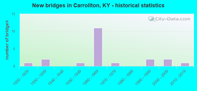
- New bridges - historical statistics
- 11920-1929
- 21930-1939
- 11950-1959
- 111960-1969
- 11970-1979
- 21990-1999
- 22000-2009
- 12010-2019


- Bridge Condition - Deck
- 7.7%Very good
- 61.5%Good
- 30.8%Satisfactory

- Bridge Condition - Superstructure
- 23.1%Very good
- 30.8%Good
- 30.8%Satisfactory
- 7.7%Fair
- 7.7%Poor

- Bridge Condition - Substructure
- 15.4%Very good
- 7.7%Good
- 61.5%Satisfactory
- 7.7%Fair
- 7.7%Poor

- Bridge Condition - Channel
- 53.8%Good
- 38.5%Satisfactory
- 7.7%Fair
Find on map >> Show street view
Structure Number: 21B00013N, Location: 2.8 MI SE OF JCT KY 55 (Lat: 38.631389, Lng: -85.139722), Route carried "on" structure: State highway 389, Year Built: 1967, Status: Open, Structure Length: 6.71m (22.01ft), Average Daily Traffic: 1,027 (year 2019), Truck Traffic: 9%, Average Future Daily Traffic: 903 (year 2039), Design Load: H 20, Features Intersected: I-71 L'VLLE-COVINGTON
Minimum Vertical Clearance: 30+ m (98+ ft), Kilometerpoint: 7.062, Lanes on structure: 2, Lanes under structure: 4, Owner: State Highway Agency, Approaching Roadway Width: 7.3m (24.0ft), Skew: 1 degrees, Material/Design: Concrete continuous, Design/Construction: Tee Beam, Number Of Spans In Main Unit: 4, Length of Maximum Span: 20.4m (66.9ft), Curb or Sidewalk Widths: Left: 0.5m (1.6ft), Right: 0.5m (1.6ft), Curb-To-Curb Width: 9.1m (29.9ft), Out-to-Out Width: 10.9m (35.8ft)
Condition: Deck: Good, Superstructure: Fair, Substructure: Satisfactory, Operating Rating: 80.8 metric tons, Method Used To Determine Operating Rating: Load Factor (LF), Inventory Rating: 48.5 metric tons, Method Used To Determine Inventory Rating: Load Factor (LF), Structural Evaluation: Somewhat better than minimum adequacy, Deck Geometry: Somewhat better than minimum adequacy, Underclear: Somewhat better than minimum adequacy, Approach Roadway Alignment: Equal to present minimum criteria, Designated Inspection Frequency: Every 24 months, Inspection Date: November 2020, Deck Structure Type: Concrete Cast-file-Place, Wearing Surface/Protective System: Wearing Surface: Latex Concrete
Find on map >> Show street view
Structure Number: 21B00014N, Location: .10 MI S.E. OF JCT KY 55 (Lat: 38.647778, Lng: -85.176389), Route carried "on" structure: State highway 389, Year Built: 1932, Status: Open, Structure Length: 1.22m (4.00ft), Average Daily Traffic: 1,027 (year 2019), Truck Traffic: 9%, Average Future Daily Traffic: 903 (year 2039), Features Intersected: MAJORS RUN
Minimum Vertical Clearance: 30+ m (98+ ft), Kilometerpoint: 11.380, Lanes on structure: 2, Owner: State Highway Agency, Approaching Roadway Width: 5.8m (19.0ft), Material/Design: Concrete, Design/Construction: Culvert, Number Of Spans In Main Unit: 3, Length of Maximum Span: 3.7m (12.1ft)
Condition: Channel: Satisfactory, Culverts: Satisfactory, Operating Rating: 99.8 metric tons, Method Used To Determine Operating Rating: Load Factor (LF), Inventory Rating: 85.5 metric tons, Method Used To Determine Inventory Rating: Load Factor (LF), Structural Evaluation: Equal to present minimum criteria, Waterway Adequacy: Equal to present desirable criteria, Approach Roadway Alignment: Equal to present minimum criteria, Designated Inspection Frequency: Every 24 months, Inspection Date: November 2020
Find on map >> Show street view
Structure Number: 21B00021N, Location: .10 MI SOU. OF JCT KY 389 (Lat: 38.648611, Lng: -85.177778), Route carried "on" structure: State highway 55, Year Built: 1924, Status: Open, Structure Length: 0.73m (2.40ft), Average Daily Traffic: 566 (year 2020), Truck Traffic: 8%, Average Future Daily Traffic: 498 (year 2040), Features Intersected: BR OF MAJORS RUN
Minimum Vertical Clearance: 30+ m (98+ ft), Kilometerpoint: 9.151, Lanes on structure: 2, Owner: State Highway Agency, Approaching Roadway Width: 5.5m (18.0ft), Skew: 3 degrees, Material/Design: Concrete, Design/Construction: Culvert, Number Of Spans In Main Unit: 2, Length of Maximum Span: 3.0m (9.8ft)
Condition: Channel: Satisfactory, Culverts: Satisfactory, Operating Rating: 54.4 metric tons, Method Used To Determine Operating Rating: Field evaluation and documented engineering judgment, Inventory Rating: 39.9 metric tons, Method Used To Determine Inventory Rating: Field evaluation and documented engineering judgment, Structural Evaluation: Equal to present minimum criteria, Waterway Adequacy: Somewhat better than minimum adequacy, Approach Roadway Alignment: Equal to present minimum criteria, Designated Inspection Frequency: Every 24 months, Inspection Date: November 2020
Find on map >> Show street view
Structure Number: 21B00037L, Location: SBL OVER KY 227 INTERCHNG (Lat: 38.647222, Lng: -85.121389), Route carried "on" structure: Interstate 71, Year Built: 1967, Status: Open, Structure Length: 7.13m (23.39ft), Average Daily Traffic: 18,644 (year 2020), Truck Traffic: 34%, Average Future Daily Traffic: 22,746 (year 2040), Design Load: HS 20, Features Intersected: CSX RR & KY 227
Minimum Vertical Clearance: 30+ m (98+ ft), Kilometerpoint: 71.341, Lanes on structure: 2, Lanes under structure: 2, Base Highway Network: Yes, Owner: State Highway Agency, Approaching Roadway Width: 11.3m (37.1ft), Material/Design: Concrete continuous, Design/Construction: Tee Beam, Number Of Spans In Main Unit: 4, Length of Maximum Span: 21.3m (69.9ft), Curb or Sidewalk Widths: Left: 0.6m (2.0ft), Right: 0.6m (2.0ft), Curb-To-Curb Width: 11.6m (38.1ft), Out-to-Out Width: 12.7m (41.7ft)
Condition: Deck: Satisfactory, Superstructure: Satisfactory, Substructure: Satisfactory, Operating Rating: 53.5 metric tons, Method Used To Determine Operating Rating: Load Factor (LF), Inventory Rating: 32.1 metric tons, Method Used To Determine Inventory Rating: Load Factor (LF), Structural Evaluation: Equal to present minimum criteria, Deck Geometry: Equal to present minimum criteria, Underclear: Equal to present minimum criteria, Approach Roadway Alignment: Equal to present minimum criteria, Length Of Structure Improvement: 0.71m (2.33ft), Designated Inspection Frequency: Every 24 months, Inspection Date: November 2020, Bridge Improvement Cost: $1,223,000, Total Project Cost: $1,222,000, Deck Structure Type: Concrete Cast-file-Place, Wearing Surface/Protective System: Wearing Surface: Latex Concrete
Find on map >> Show street view
Structure Number: 21B00037R, Location: NBL OVER KY 227 INTERCHNG (Lat: 38.646944, Lng: -85.121111), Route carried "on" structure: Interstate 71, Year Built: 1967, Status: Open, Structure Length: 7.13m (23.39ft), Average Daily Traffic: 18,644 (year 2020), Truck Traffic: 34%, Average Future Daily Traffic: 22,746 (year 2040), Design Load: HS 20, Features Intersected: CSX RR & KY 227
Minimum Vertical Clearance: 30+ m (98+ ft), Kilometerpoint: 71.357, Lanes on structure: 2, Lanes under structure: 2, Base Highway Network: Yes, Owner: State Highway Agency, Approaching Roadway Width: 11.3m (37.1ft), Material/Design: Concrete continuous, Design/Construction: Tee Beam, Number Of Spans In Main Unit: 4, Length of Maximum Span: 21.3m (69.9ft), Curb-To-Curb Width: 11.6m (38.1ft), Out-to-Out Width: 12.7m (41.7ft)
Condition: Deck: Satisfactory, Superstructure: Good, Substructure: Satisfactory, Operating Rating: 50.0 metric tons, Method Used To Determine Operating Rating: Load Factor (LF), Inventory Rating: 29.9 metric tons, Method Used To Determine Inventory Rating: Load Factor (LF), Structural Evaluation: Equal to present minimum criteria, Deck Geometry: Equal to present minimum criteria, Underclear: Equal to present minimum criteria, Approach Roadway Alignment: Equal to present minimum criteria, Length Of Structure Improvement: 0.71m (2.33ft), Designated Inspection Frequency: Every 24 months, Inspection Date: November 2020, Bridge Improvement Cost: $1,223,000, Total Project Cost: $1,222,000, Deck Structure Type: Concrete Cast-file-Place, Wearing Surface/Protective System: Wearing Surface: Latex Concrete
Find on map >> Show street view
Structure Number: 21B00040N, Location: .30 MI SOU. OF KY RVR BR (Lat: 38.638056, Lng: -85.127500), Route carried "on" structure: Interstate 71, Year Built: 1967, Status: Open, Structure Length: 0.62m (2.03ft), Average Daily Traffic: 43,277 (year 2020), Truck Traffic: 17%, Average Future Daily Traffic: 52,797 (year 2040), Design Load: HS 20, Features Intersected: GREEN BOTTOM ROAD
Minimum Vertical Clearance: 30+ m (98+ ft), Kilometerpoint: 70.233, Lanes on structure: 4, Lanes under structure: 2, Base Highway Network: Yes, Owner: State Highway Agency, Approaching Roadway Width: 11.3m (37.1ft), Skew: 20 degrees, Material/Design: Concrete, Design/Construction: Culvert, Number Of Spans In Main Unit: 1, Length of Maximum Span: 6.1m (20.0ft)
Condition: Culverts: Satisfactory, Operating Rating: 85.7 metric tons, Method Used To Determine Operating Rating: Load Factor (LF), Inventory Rating: 51.4 metric tons, Method Used To Determine Inventory Rating: Load Factor (LF), Structural Evaluation: Equal to present minimum criteria, Underclear: High priority of corrective action, Approach Roadway Alignment: Equal to present minimum criteria, Length Of Structure Improvement: 0.07m (0.23ft), Designated Inspection Frequency: Every 24 months, Inspection Date: November 2020, Bridge Improvement Cost: $58,000, Total Project Cost: $57,000
Find on map >> Show street view
Structure Number: 21B00042L, Location: SBL .2 MI SW-KY 227 NTRCH (Lat: 38.643056, Lng: -85.124722), Route carried "on" structure: Interstate 71, Year Built: 1967, Status: Open, Structure Length: 23.44m (76.90ft), Average Daily Traffic: 21,639 (year 2020), Truck Traffic: 17%, Average Future Daily Traffic: 26,399 (year 2040), Design Load: HS 20, Features Intersected: KENTUCKY RIVER
Minimum Vertical Clearance: 30+ m (98+ ft), Kilometerpoint: 70.818, Lanes on structure: 2, Base Highway Network: Yes, Owner: State Highway Agency, Approaching Roadway Width: 11.0m (36.1ft), Navigation Control: Yes ( Vertical Clearance: 16.7m (54.8ft), Horizontal Clearance: 97.2m (318.9ft)), Material/Design: Steel continuous, Design/Construction: Girder and Floorbeam System, Number Of Spans In Main Unit: 3, Length of Maximum Span: 97.5m (319.9ft), Curb or Sidewalk Widths: Left: 0.5m (1.6ft), Right: 0.5m (1.6ft), Curb-To-Curb Width: 9.1m (29.9ft), Out-to-Out Width: 10.9m (35.8ft)
Condition: Deck: Good, Superstructure: Satisfactory, Substructure: Good, Channel: Good, Operating Rating: 58.5 metric tons, Method Used To Determine Operating Rating: Load Factor (LF), Inventory Rating: 35.1 metric tons, Method Used To Determine Inventory Rating: Load Factor (LF), Structural Evaluation: Equal to present minimum criteria, Deck Geometry: Meets minimum limits, Waterway Adequacy: Equal to present desirable criteria, Approach Roadway Alignment: Equal to present minimum criteria, Designated Inspection Frequency: Every 24 months, Critical Feature Inspection Frequency: Every 24 months, Underwater Inspection Frequency: Every 60 months, Inspection Date: September 2021, Critical Feature Inspection Date: September 2021, Underwater Inspection Date: November 2021, Deck Structure Type: Concrete Cast-file-Place, Wearing Surface/Protective System: Wearing Surface: Latex Concrete
Find on map >> Show street view
Structure Number: 21B00042R, Location: NBL .2 MI SW-KY 227 NTRCH (Lat: 38.643056, Lng: -85.124444), Route carried "on" structure: Interstate 71, Year Built: 1967, Status: Open, Structure Length: 23.44m (76.90ft), Average Daily Traffic: 21,639 (year 2020), Truck Traffic: 17%, Average Future Daily Traffic: 26,399 (year 2040), Design Load: HS 20, Features Intersected: KENTUCKY RIVER
Minimum Vertical Clearance: 30+ m (98+ ft), Kilometerpoint: 70.842, Lanes on structure: 2, Base Highway Network: Yes, Owner: State Highway Agency, Approaching Roadway Width: 11.0m (36.1ft), Navigation Control: Yes ( Vertical Clearance: 16.7m (54.8ft), Horizontal Clearance: 97.2m (318.9ft)), Material/Design: Steel continuous, Design/Construction: Girder and Floorbeam System, Number Of Spans In Main Unit: 3, Length of Maximum Span: 97.5m (319.9ft), Curb or Sidewalk Widths: Left: 0.5m (1.6ft), Right: 0.5m (1.6ft), Curb-To-Curb Width: 9.1m (29.9ft), Out-to-Out Width: 10.9m (35.8ft)
Condition: Deck: Good, Superstructure: Satisfactory, Substructure: Satisfactory, Channel: Good, Operating Rating: 58.5 metric tons, Method Used To Determine Operating Rating: Load Factor (LF), Inventory Rating: 35.1 metric tons, Method Used To Determine Inventory Rating: Load Factor (LF), Structural Evaluation: Equal to present minimum criteria, Deck Geometry: Meets minimum limits, Waterway Adequacy: Equal to present desirable criteria, Approach Roadway Alignment: Equal to present minimum criteria, Designated Inspection Frequency: Every 24 months, Critical Feature Inspection Frequency: Every 24 months, Underwater Inspection Frequency: Every 60 months, Inspection Date: September 2021, Critical Feature Inspection Date: September 2021, Underwater Inspection Date: November 2021, Deck Structure Type: Concrete Cast-file-Place, Wearing Surface/Protective System: Wearing Surface: Latex Concrete
Find on map >> Show street view
Structure Number: 21B00043N, Location: .20 MI EAST OF JCT KY 55 (Lat: 38.680278, Lng: -85.187778), Route carried "on" structure: US 42, Year Built: 1952, Status: Posted for load, Structure Length: 38.92m (127.69ft), Average Daily Traffic: 7,503 (year 2020), Truck Traffic: 8%, Average Future Daily Traffic: 6,977 (year 2040), Design Load: H 20, Features Intersected: KENTUCKY RIVER & CITY ST
Minimum Vertical Clearance: 4.88m (16.01ft), Kilometerpoint: 9.370, Lanes on structure: 2, Owner: State Highway Agency, Approaching Roadway Width: 6.1m (20.0ft), Navigation Control: Yes ( Vertical Clearance: 21.1m (69.2ft), Horizontal Clearance: 88.4m (290.0ft)), Material/Design: Steel continuous, Design/Construction: Truss - Thru, Number Of Spans In Main Unit: 3, Number Of Approach Spans: 9, Length of Maximum Span: 91.4m (299.9ft), Curb or Sidewalk Widths: Left: 1.5m (4.9ft), Right: 1.5m (4.9ft), Curb-To-Curb Width: 7.9m (25.9ft), Out-to-Out Width: 8.8m (28.9ft)
Condition: Deck: Satisfactory, Superstructure: Poor, Substructure: Fair, Channel: Good, Operating Rating: 27.5 metric tons, Method Used To Determine Operating Rating: Load Factor (LF), Inventory Rating: 16.4 metric tons, Method Used To Determine Inventory Rating: Load Factor (LF), Structural Evaluation: Meets minimum limits, Deck Geometry: High priority of corrective action, Waterway Adequacy: Equal to present desirable criteria, Approach Roadway Alignment: Equal to present minimum criteria, Bridge Posting: Required (Relationship of Operating Rating to Maximum Legal Load: > 39.9% below), Length Of Structure Improvement: 3.89m (12.76ft), Designated Inspection Frequency: Every 12 months, Critical Feature Inspection Frequency: Every 24 months, Underwater Inspection Frequency: Every 60 months, Inspection Date: June 2021, Critical Feature Inspection Date: June 2021, Underwater Inspection Date: May 2019, Bridge Improvement Cost: $4,629,000, Total Project Cost: $4,629,000, Deck Structure Type: Concrete Cast-file-Place, Wearing Surface/Protective System: Wearing Surface: Latex Concrete
Find on map >> Show street view
Structure Number: 21B00045N, Location: .05 MI N OF JCT KY 1112 (Lat: 38.641944, Lng: -85.114167), Route carried "on" structure: State highway 227, Year Built: 1974, Status: Open, Structure Length: 7.89m (25.89ft), Average Daily Traffic: 13,683 (year 2019), Truck Traffic: 9%, Average Future Daily Traffic: 11,356 (year 2039), Design Load: HS 20+Mod, Features Intersected: WHITES RUN
Minimum Vertical Clearance: 30+ m (98+ ft), Kilometerpoint: 5.993, Lanes on structure: 2, Base Highway Network: Yes, Owner: State Highway Agency, Approaching Roadway Width: 7.3m (24.0ft), Material/Design: Prestressed concrete continuous, Design/Construction: Stringer/Multi-beam, Number Of Spans In Main Unit: 3, Length of Maximum Span: 19.5m (64.0ft), Curb or Sidewalk Widths: Left: 0.5m (1.6ft), Right: 0.5m (1.6ft), Curb-To-Curb Width: 13.4m (44.0ft), Out-to-Out Width: 14.5m (47.6ft)
Condition: Deck: Good, Superstructure: Good, Substructure: Satisfactory, Channel: Good, Operating Rating: 99.2 metric tons, Method Used To Determine Operating Rating: Load Factor (LF), Inventory Rating: 59.5 metric tons, Method Used To Determine Inventory Rating: Load Factor (LF), Structural Evaluation: Equal to present minimum criteria, Deck Geometry: Equal to present minimum criteria, Waterway Adequacy: Better than present minimum criteria, Approach Roadway Alignment: Equal to present minimum criteria, Designated Inspection Frequency: Every 24 months, Inspection Date: November 2020, Deck Structure Type: Concrete Cast-file-Place, Wearing Surface/Protective System: Wearing Surface: Latex Concrete, Deck Protection: Epoxy Coated Reinforcing
Find on map >> Show street view
Structure Number: 21B00055N, Location: .6 MI S. JCT KY 389 (Lat: 38.643611, Lng: -85.182222), Route carried "on" structure: State highway 55, Year Built: 1990, Status: Open, Structure Length: 1.77m (5.81ft), Average Daily Traffic: 566 (year 2020), Truck Traffic: 8%, Average Future Daily Traffic: 498 (year 2040), Design Load: HS 25 or greater, Features Intersected: MAJORS RUN CREEK
Minimum Vertical Clearance: 30+ m (98+ ft), Kilometerpoint: 8.447, Lanes on structure: 2, Owner: State Highway Agency, Approaching Roadway Width: 13.7m (44.9ft), Skew: 3 degrees, Material/Design: Prestressed concrete, Design/Construction: Stringer/Multi-beam, Number Of Spans In Main Unit: 1, Length of Maximum Span: 16.8m (55.1ft), Curb-To-Curb Width: 11.3m (37.1ft), Out-to-Out Width: 12.3m (40.4ft)
Condition: Deck: Good, Superstructure: Good, Substructure: Satisfactory, Channel: Satisfactory, Operating Rating: 79.0 metric tons, Method Used To Determine Operating Rating: Load Factor (LF), Inventory Rating: 47.4 metric tons, Method Used To Determine Inventory Rating: Load Factor (LF), Structural Evaluation: Equal to present minimum criteria, Deck Geometry: Better than present minimum criteria, Waterway Adequacy: Better than present minimum criteria, Approach Roadway Alignment: Better than present minimum criteria, Designated Inspection Frequency: Every 24 months, Inspection Date: November 2020, Deck Structure Type: Concrete Cast-file-Place, Wearing Surface/Protective System: Wearing Surface: Monolithic Concrete, Deck Protection: Epoxy Coated Reinforcing
Find on map >> Show street view
Structure Number: 21B00057N, Location: 2.5 MI N.E. OF JCT KY 36 (Lat: 38.701667, Lng: -85.122222), Route carried "on" structure: US 42, Year Built: 2007, Status: Open, Structure Length: 5.32m (17.45ft), Average Daily Traffic: 8,251 (year 2019), Truck Traffic: 23%, Average Future Daily Traffic: 7,260 (year 2039), Design Load: HS 25 or greater, Features Intersected: FOUR MILE CREEK
Minimum Vertical Clearance: 30+ m (98+ ft), Kilometerpoint: 15.664, Lanes on structure: 2, Owner: State Highway Agency, Approaching Roadway Width: 18.5m (60.7ft), Material/Design: Prestressed concrete, Design/Construction: Stringer/Multi-beam, Number Of Spans In Main Unit: 3, Length of Maximum Span: 18.3m (60.0ft), Curb or Sidewalk Widths: Left: 0.5m (1.6ft), Right: 0.5m (1.6ft), Curb-To-Curb Width: 18.4m (60.4ft), Out-to-Out Width: 19.4m (63.6ft)
Condition: Deck: Good, Superstructure: Very good, Substructure: Very good, Channel: Satisfactory, Operating Rating: 47.6 metric tons, Method Used To Determine Operating Rating: Load Factor (LF), Inventory Rating: 28.6 metric tons, Method Used To Determine Inventory Rating: Load Factor (LF), Structural Evaluation: Better than present minimum criteria, Deck Geometry: Superior to present desirable criteria, Waterway Adequacy: Better than present minimum criteria, Approach Roadway Alignment: Equal to present desirable criteria, Designated Inspection Frequency: Every 24 months, Inspection Date: November 2020, Deck Structure Type: Concrete Cast-file-Place, Wearing Surface/Protective System: Wearing Surface: Monolithic Concrete, Deck Protection: Epoxy Coated Reinforcing
Find on map >> Show street view
Structure Number: 21B00058N, Location: .5 mi S I-71 English exit (Lat: 38.628333, Lng: -85.136944), Route carried "on" structure: State highway 389, Year Built: 2006, Status: Open, Structure Length: 8.38m (27.49ft), Average Daily Traffic: 691 (year 2019), Truck Traffic: 9%, Average Future Daily Traffic: 608 (year 2039), Design Load: HS 25 or greater, Features Intersected: W. FK. OF MILL CREEK
Minimum Vertical Clearance: 30+ m (98+ ft), Kilometerpoint: 6.627, Lanes on structure: 2, Owner: State Highway Agency, Approaching Roadway Width: 9.8m (32.2ft), Skew: 4 degrees, Material/Design: Prestressed concrete continuous, Design/Construction: Stringer/Multi-beam, Number Of Spans In Main Unit: 3, Length of Maximum Span: 30.8m (101.0ft), Curb-To-Curb Width: 9.8m (32.2ft), Out-to-Out Width: 10.7m (35.1ft)
Condition: Deck: Good, Superstructure: Very good, Substructure: Satisfactory, Channel: Good, Operating Rating: 77.6 metric tons, Method Used To Determine Operating Rating: Load Factor (LF), Inventory Rating: 46.5 metric tons, Method Used To Determine Inventory Rating: Load Factor (LF), Structural Evaluation: Equal to present minimum criteria, Deck Geometry: Equal to present minimum criteria, Waterway Adequacy: Better than present minimum criteria, Approach Roadway Alignment: Equal to present desirable criteria, Designated Inspection Frequency: Every 24 months, Inspection Date: November 2020, Deck Structure Type: Concrete Cast-file-Place, Wearing Surface/Protective System: Wearing Surface: Monolithic Concrete, Deck Protection: Epoxy Coated Reinforcing
Find on map >> Show street view
Structure Number: 21B00062N, Location: 1.0 MI SOU. OF JCT KY 389 (Lat: 38.635278, Lng: -85.181111), Route carried "on" structure: State highway 55, Year Built: 2019, Status: Open, Structure Length: 0.91m (2.99ft), Average Daily Traffic: 566 (year 2020), Truck Traffic: 8%, Average Future Daily Traffic: 498 (year 2040), Design Load: Greater than HL93, Features Intersected: Majors Run Creek
Minimum Vertical Clearance: 30+ m (98+ ft), Kilometerpoint: 7.430, Lanes on structure: 2, Owner: State Highway Agency, Approaching Roadway Width: 5.8m (19.0ft), Skew: 3 degrees, Material/Design: Concrete, Design/Construction: Slab, Number Of Spans In Main Unit: 1, Length of Maximum Span: 8.5m (27.9ft), Curb-To-Curb Width: 6.2m (20.3ft), Out-to-Out Width: 6.7m (22.0ft)
Condition: Deck: Very good, Superstructure: Very good, Substructure: Very good, Channel: Good, Operating Rating: 71.6 metric tons, Method Used To Determine Operating Rating: Load and Resistance Factor Rating (LRFR) rating reported by rating factor(RF) method using HL-93 loadings, Inventory Rating: 55.4 metric tons, Method Used To Determine Inventory Rating: Load and Resistance Factor Rating (LRFR) rating reported by rating factor(RF) method using HL-93 loadings, Structural Evaluation: Equal to present desirable criteria, Deck Geometry: High priority of corrective action, Waterway Adequacy: Somewhat better than minimum adequacy, Approach Roadway Alignment: Better than present minimum criteria, Designated Inspection Frequency: Every 24 months, Inspection Date: November 2020, Deck Structure Type: Concrete Cast-file-Place, Wearing Surface/Protective System: Wearing Surface: Monolithic Concrete, Deck Protection: Epoxy Coated Reinforcing
Find on map >> Show street view
Structure Number: 21C00006N, Location: 1MI SE OF W-JCT KY 36 (Lat: 38.666111, Lng: -85.109722), Route carried "on" structure: County highway 1019, Year Built: 1968, Status: Open, Structure Length: 0.79m (2.59ft), Average Daily Traffic: 208 (year 2006), Average Future Daily Traffic: 377 (year 2026), Design Load: H 20, Features Intersected: TRIB. TO KY. RIVER, Facility Carried by Structure: BOONE ROAD
Minimum Vertical Clearance: 30+ m (98+ ft), Kilometerpoint: 1.825, Lanes on structure: 2, Owner: County Highway Agency, Approaching Roadway Width: 4.6m (15.1ft), Material/Design: Prestressed concrete, Design/Construction: Box Beam or Girders - Multiple, Number Of Spans In Main Unit: 1, Length of Maximum Span: 7.3m (24.0ft), Curb-To-Curb Width: 5.9m (19.4ft), Out-to-Out Width: 6.6m (21.7ft)
Condition: Deck: Satisfactory, Superstructure: Satisfactory, Substructure: Poor, Channel: Fair, Operating Rating: 96.2 metric tons, Method Used To Determine Operating Rating: Load Factor (LF), Inventory Rating: 57.7 metric tons, Method Used To Determine Inventory Rating: Load Factor (LF), Structural Evaluation: Meets minimum limits, Deck Geometry: High priority of corrective action, Waterway Adequacy: Somewhat better than minimum adequacy, Approach Roadway Alignment: Somewhat better than minimum adequacy, Length Of Structure Improvement: 0.08m (0.26ft), Designated Inspection Frequency: Every 24 months, Inspection Date: Febuary 2021, Bridge Improvement Cost: $70,000, Total Project Cost: $69,000, Deck Structure Type: Concrete Precast Panels, Wearing Surface/Protective System: Wearing Surface: Monolithic Concrete
Find on map >> Show street view
Structure Number: 21C00021N, Location: .3 MI SE OF JCT US 42 (Lat: 38.699167, Lng: -85.113056), Route carried "on" structure: County highway 1001, Year Built: 1939, Year Reconstructed: 1986, Status: Open, Structure Length: 0.91m (2.99ft), Average Daily Traffic: 220 (year 2006), Average Future Daily Traffic: 399 (year 2026), Features Intersected: MCCOOLS CREEK, Facility Carried by Structure: FOUR MILE ROAD
Minimum Vertical Clearance: 30+ m (98+ ft), Kilometerpoint: 3.647, Lanes on structure: 1, Owner: County Highway Agency, Approaching Roadway Width: 7.3m (24.0ft), Skew: 4 degrees, Material/Design: Concrete, Design/Construction: Culvert, Number Of Spans In Main Unit: 2, Length of Maximum Span: 8.5m (27.9ft)
Condition: Channel: Satisfactory, Culverts: Satisfactory, Operating Rating: 54.4 metric tons, Method Used To Determine Operating Rating: Field evaluation and documented engineering judgment, Inventory Rating: 39.9 metric tons, Method Used To Determine Inventory Rating: Field evaluation and documented engineering judgment, Structural Evaluation: Equal to present minimum criteria, Waterway Adequacy: Equal to present minimum criteria, Approach Roadway Alignment: Better than present minimum criteria, Designated Inspection Frequency: Every 24 months, Inspection Date: Febuary 2021
Find on map >> Show street view
Structure Number: 21C00029N, Location: 50' SOUTH JCT CR 5211 (Lat: 38.611944, Lng: -85.196389), Route carried "on" structure: County highway 1209, Year Built: 1993, Status: Open, Structure Length: 0.67m (2.20ft), Average Daily Traffic: 304 (year 2006), Average Future Daily Traffic: 551 (year 2026), Design Load: HS 25 or greater, Features Intersected: MELLINS CREEK, Facility Carried by Structure: GEORGES CREEK ROAD
Minimum Vertical Clearance: 30+ m (98+ ft), Kilometerpoint: 0.164, Lanes on structure: 2, Owner: County Highway Agency, Approaching Roadway Width: 3.7m (12.1ft), Material/Design: Prestressed concrete, Design/Construction: Box Beam or Girders - Multiple, Number Of Spans In Main Unit: 1, Length of Maximum Span: 6.4m (21.0ft), Curb-To-Curb Width: 6.9m (22.6ft), Out-to-Out Width: 7.4m (24.3ft)
Condition: Deck: Good, Superstructure: Good, Substructure: Satisfactory, Channel: Good, Operating Rating: 71.5 metric tons, Method Used To Determine Operating Rating: Load Factor (LF), Inventory Rating: 42.9 metric tons, Method Used To Determine Inventory Rating: Load Factor (LF), Structural Evaluation: Equal to present minimum criteria, Deck Geometry: Meets minimum limits, Waterway Adequacy: Better than present minimum criteria, Approach Roadway Alignment: Equal to present minimum criteria, Designated Inspection Frequency: Every 24 months, Inspection Date: Febuary 2021, Deck Structure Type: Concrete Precast Panels, Wearing Surface/Protective System: Wearing Surface: Monolithic Concrete, Deck Protection: Epoxy Coated Reinforcing
Find on map >> Show street view
Structure Number: 21B00013N, Location: 2.8 MI SE OF JCT KY 55 (Lat: 38.631389, Lng: -85.139722), Route carried "under" structure: Interstate 71, Year Built: 1967, Structure Length: 0. m, Average Daily Traffic: 43,277 (year 2020), Truck Traffic: 17%, Features Intersected: I-71 L'VLLE-COVINGTON, Facility Carried by Structure: KY-389
Minimum Vertical Clearance: 5.64m (18.50ft), Kilometerpoint: 68.899, Lanes on structure: 2, Lanes under structure: 4, Material/Design: Concrete continuous, Design/Construction: Tee Beam, Length of Maximum Span: 20.4m (66.9ft)
Find on map >> Show street view
Structure Number: 21B00037L, Location: SBL OVER KY 227 INTERCHNG (Lat: 38.647222, Lng: -85.121389), Route carried "under" structure: State highway 227, Year Built: 1967, Structure Length: 0. m, Average Daily Traffic: 13,683 (year 2019), Truck Traffic: 9%, Features Intersected: CSX RR & KY 227, Facility Carried by Structure: I-71
Minimum Vertical Clearance: 5.33m (17.49ft), Kilometerpoint: 6.848, Lanes on structure: 2, Lanes under structure: 2, Material/Design: Concrete continuous, Design/Construction: Tee Beam, Length of Maximum Span: 21.3m (69.9ft)
Find on map >> Show street view
Structure Number: 21B00037R, Location: NBL OVER KY 227 INTERCHNG (Lat: 38.646944, Lng: -85.121111), Route carried "under" structure: State highway 227, Year Built: 1967, Structure Length: 0. m, Average Daily Traffic: 13,683 (year 2019), Truck Traffic: 9%, Features Intersected: CSX RR & KY 227, Facility Carried by Structure: I-71
Minimum Vertical Clearance: 5.49m (18.01ft), Kilometerpoint: 6.820, Lanes on structure: 2, Lanes under structure: 2, Material/Design: Concrete continuous, Design/Construction: Tee Beam, Length of Maximum Span: 21.3m (69.9ft)
Find on map >> Show street view
Structure Number: 21B00040N, Location: .30 MI SOU. OF KY RVR BR (Lat: 38.638056, Lng: -85.127500), Route carried "under" structure: County highway 1116, Year Built: 1967, Structure Length: 0. m, Average Daily Traffic: 128 (year 2006), Features Intersected: GREEN BOTTOM ROAD, Facility Carried by Structure: I-71
Minimum Vertical Clearance: 4.26m (13.98ft), Kilometerpoint: 1.283, Lanes on structure: 4, Lanes under structure: 2, Material/Design: Concrete, Design/Construction: Culvert, Length of Maximum Span: 6.1m (20.0ft)