Bridge Statistics for Cascade Locks, Oregon (OR)
Condition, Traffic, Stress, Structural Evaluation, Project Costs
- National Bridge Inventory (NBI) Statistics
- 20Number of bridges
- 427ft / 130mTotal length
- $12,468,000Total costs
- 218,480Total average daily traffic
- 57,761Total average daily truck traffic
- National Bridge Inventory (NBI) Registered Bridges for Cascade Locks
- No street view available for this location
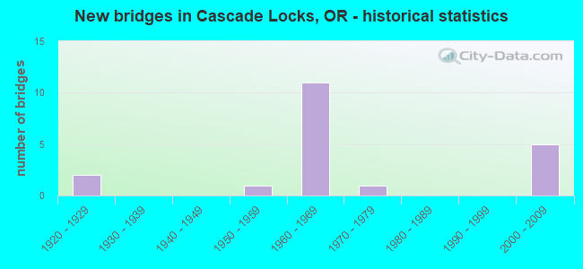
- New bridges - historical statistics
- 21920-1929
- 11950-1959
- 111960-1969
- 11970-1979
- 52000-2009


- Bridge Condition - Deck
- 78.6%Good
- 14.3%Satisfactory
- 7.1%Fair

- Bridge Condition - Superstructure
- 7.1%Very good
- 64.3%Good
- 21.4%Satisfactory
- 7.1%Fair

- Bridge Condition - Substructure
- 35.7%Very good
- 35.7%Good
- 21.4%Satisfactory
- 7.1%Fair

- Bridge Condition - Channel
- 40.0%Very good
- 40.0%Good
- 20.0%Poor
Find on map >> Show street view
Structure Number: 159A604 00081, Location: 01.5 MI E OF OLD HWY 30 (Lat: 45.678961, Lng: -121.860689), Route carried "on" structure: County highway B0436, Year Built: 1979, Status: Open, Structure Length: 2.62m (8.60ft), Average Daily Traffic: 1,775 (year 2020), Truck Traffic: 10%, Average Future Daily Traffic: 1,980 (year 2025), Design Load: HS 20, Features Intersected: HERMAN CREEK, Facility Carried by Structure: FOREST LANE
Minimum Vertical Clearance: 30+ m (98+ ft), Kilometerpoint: 1.304, Lanes on structure: 2, Owner: County Highway Agency, Approaching Roadway Width: 7.3m (24.0ft), Material/Design: Prestressed concrete, Design/Construction: Stringer/Multi-beam, Number Of Spans In Main Unit: 1, Length of Maximum Span: 25.9m (85.0ft), Curb-To-Curb Width: 9.1m (29.9ft), Out-to-Out Width: 9.8m (32.2ft)
Condition: Deck: Satisfactory, Superstructure: Good, Substructure: Satisfactory, Channel: Poor, Operating Rating: 40.8 metric tons, Method Used To Determine Operating Rating: Load and Resistance Factor Rating (LRFR) rating reported by rating factor(RF) method using HL-93 loadings, Inventory Rating: 31.4 metric tons, Method Used To Determine Inventory Rating: Load and Resistance Factor Rating (LRFR) rating reported by rating factor(RF) method using HL-93 loadings, Structural Evaluation: Equal to present minimum criteria, Deck Geometry: Somewhat better than minimum adequacy, Waterway Adequacy: Equal to present minimum criteria, Approach Roadway Alignment: Equal to present desirable criteria, Designated Inspection Frequency: Every 24 months, Inspection Date: September 2020, Deck Structure Type: Concrete Cast-file-Place, Wearing Surface/Protective System: Wearing Surface: Monolithic Concrete
Find on map >> Show street view
Structure Number: 2592 283 00039, Location: IN CASCADE LOCKS (Lat: 45.662350, Lng: -121.901050), Route carried "on" structure: Other road , Year Built: 1924, Status: Posted for load, Structure Length: 56.54m (185.50ft), Average Daily Traffic: 5,208 (year 2010), Truck Traffic: 8%, Average Future Daily Traffic: 7,600 (year 2030), Design Load: H 20, Features Intersected: BR OF THE GODS, Facility Carried by Structure: TOLL BR
Minimum Vertical Clearance: 4.42m (14.50ft), Kilometerpoint: 48.956, Lanes on structure: 2, Lanes under structure: 2, Toll: Toll bridge, Owner: Local Toll Authority, Approaching Roadway Width: 14.0m (45.9ft), Material/Design: Steel continuous, Design/Construction: Truss - Thru, Number Of Spans In Main Unit: 3, Number Of Approach Spans: 7, Length of Maximum Span: 215.8m (708.0ft), Curb-To-Curb Width: 6.7m (22.0ft), Out-to-Out Width: 7.2m (23.6ft)
Condition: Deck: Fair, Superstructure: Fair, Substructure: Fair, Channel: Good, Operating Rating: 12.0 metric tons, Method Used To Determine Operating Rating: Load and Resistance Factor Rating (LRFR) rating reported by rating factor(RF) method using HL-93 loadings, Inventory Rating: 9.4 metric tons, Method Used To Determine Inventory Rating: Load and Resistance Factor Rating (LRFR) rating reported by rating factor(RF) method using HL-93 loadings, Structural Evaluation: High priority of corrective action, Deck Geometry: High priority of replacement, Underclear: High priority of corrective action, Waterway Adequacy: Superior to present desirable criteria, Approach Roadway Alignment: Equal to present desirable criteria, Bridge Posting: Required (Relationship of Operating Rating to Maximum Legal Load: 20.0 - 29.9% below), Length Of Structure Improvement: 56.50m (185.37ft), Designated Inspection Frequency: Every 24 months, Critical Feature Inspection Frequency: Every 24 months, Underwater Inspection Frequency: Every 60 months, Inspection Date: October 2021, Critical Feature Inspection Date: October 2021, Underwater Inspection Date: September 2019, Bridge Improvement Cost: $5,940,000, Roadway Improvement Cost: $594,000, Total Project Cost: $9,504,000, Deck Structure Type: Open Grating
Find on map >> Show street view
Structure Number: 7403A002 0461, Location: 0.1 MI E CASCADE LOCKS (Lat: 45.677586, Lng: -121.856072), Route carried "on" structure: Interstate 84, Year Built: 1952, Status: Open, Structure Length: 3.81m (12.50ft), Average Daily Traffic: 22,858 (year 2020), Truck Traffic: 28%, Average Future Daily Traffic: 34,000 (year 2040), Design Load: HS 20, Features Intersected: HERMAN CREEK
Minimum Vertical Clearance: 30+ m (98+ ft), Kilometerpoint: 74.191, Lanes on structure: 4, Base Highway Network: Yes, Owner: State Highway Agency, Approaching Roadway Width: 27.4m (89.9ft), Material/Design: Concrete continuous, Design/Construction: Stringer/Multi-beam, Number Of Spans In Main Unit: 3, Length of Maximum Span: 14.9m (48.9ft), Curb-To-Curb Width: 27.1m (88.9ft), Out-to-Out Width: 27.6m (90.6ft)
Condition: Deck: Good, Superstructure: Satisfactory, Substructure: Good, Channel: Very good, Operating Rating: 27.2 metric tons, Method Used To Determine Operating Rating: Load and Resistance Factor Rating (LRFR) rating reported by rating factor(RF) method using HL-93 loadings, Inventory Rating: 20.7 metric tons, Method Used To Determine Inventory Rating: Load and Resistance Factor Rating (LRFR) rating reported by rating factor(RF) method using HL-93 loadings, Structural Evaluation: Somewhat better than minimum adequacy, Deck Geometry: Superior to present desirable criteria, Waterway Adequacy: Equal to present desirable criteria, Approach Roadway Alignment: Equal to present desirable criteria, Designated Inspection Frequency: Every 24 months, Inspection Date: June 2020, Deck Structure Type: Concrete Cast-file-Place, Wearing Surface/Protective System: Wearing Surface: Bituminous, Membrane: Preformed Fabric
Find on map >> Show street view
Structure Number: 7403B002F04606, Location: 1.0 MI E CASCADE LOCKS (Lat: 45.677319, Lng: -121.855861), Route carried "on" structure: ServiceState highway 84, Year Built: 1965, Status: Open, Structure Length: 3.81m (12.50ft), Average Daily Traffic: 148 (year 2020), Truck Traffic: 29%, Average Future Daily Traffic: 210 (year 2030), Design Load: HS 20, Features Intersected: HERMAN CREEK, Facility Carried by Structure: FRONTAGE RD2
Minimum Vertical Clearance: 30+ m (98+ ft), Kilometerpoint: 74.126, Lanes on structure: 2, Owner: State Highway Agency, Approaching Roadway Width: 7.3m (24.0ft), Material/Design: Concrete continuous, Design/Construction: Slab, Number Of Spans In Main Unit: 3, Length of Maximum Span: 15.2m (49.9ft), Curb-To-Curb Width: 7.3m (24.0ft), Out-to-Out Width: 9.1m (29.9ft)
Condition: Deck: Good, Superstructure: Good, Substructure: Good, Channel: Good, Operating Rating: 37.2 metric tons, Method Used To Determine Operating Rating: Load Factor (LF), Inventory Rating: 22.7 metric tons, Method Used To Determine Inventory Rating: Load Factor (LF), Structural Evaluation: Equal to present minimum criteria, Deck Geometry: Somewhat better than minimum adequacy, Waterway Adequacy: Equal to present desirable criteria, Approach Roadway Alignment: Equal to present desirable criteria, Designated Inspection Frequency: Every 24 months, Inspection Date: June 2020, Deck Structure Type: Concrete Cast-file-Place, Wearing Surface/Protective System: Wearing Surface: Bituminous
Find on map >> Show street view
Structure Number: 8609 002 04366, Location: 0.1 MI E OF CASCADE LOCKS (Lat: 45.659719, Lng: -121.898039), Route carried "on" structure: Interstate 84, Year Built: 1962, Status: Open, Structure Length: 8.41m (27.59ft), Average Daily Traffic: 22,052 (year 2020), Truck Traffic: 28%, Average Future Daily Traffic: 26,000 (year 2040), Design Load: HS 20, Features Intersected: O'XING EB HWY 100
Minimum Vertical Clearance: 30+ m (98+ ft), Kilometerpoint: 70.264, Lanes on structure: 4, Lanes under structure: 1, Base Highway Network: Yes, Owner: State Highway Agency, Approaching Roadway Width: 23.2m (76.1ft), Material/Design: Steel, Design/Construction: Stringer/Multi-beam, Number Of Spans In Main Unit: 1, Number Of Approach Spans: 4, Length of Maximum Span: 31.7m (104.0ft), Curb-To-Curb Width: 19.3m (63.3ft), Out-to-Out Width: 20.6m (67.6ft)
Condition: Deck: Good, Superstructure: Satisfactory, Substructure: Satisfactory, Operating Rating: 24.0 metric tons, Method Used To Determine Operating Rating: Load and Resistance Factor Rating (LRFR) rating reported by rating factor(RF) method using HL-93 loadings, Inventory Rating: 18.5 metric tons, Method Used To Determine Inventory Rating: Load and Resistance Factor Rating (LRFR) rating reported by rating factor(RF) method using HL-93 loadings, Structural Evaluation: Meets minimum limits, Deck Geometry: Somewhat better than minimum adequacy, Underclear: Equal to present minimum criteria, Approach Roadway Alignment: Equal to present desirable criteria, Designated Inspection Frequency: Every 24 months, Inspection Date: June 2020, Deck Structure Type: Concrete Cast-file-Place, Wearing Surface/Protective System: Wearing Surface: Bituminous
Find on map >> Show street view
Structure Number: 8610 002 04393, Location: IN CASCADE LOCKS (Lat: 45.662739, Lng: -121.894569), Route carried "on" structure: Interstate 84, Year Built: 1962, Year Reconstructed: 2009, Status: Open, Structure Length: 6.95m (22.80ft), Average Daily Traffic: 11,026 (year 2020), Truck Traffic: 28%, Average Future Daily Traffic: 13,000 (year 2040), Design Load: HS 20, Features Intersected: MOODY ST
Minimum Vertical Clearance: 30+ m (98+ ft), Kilometerpoint: 70.698, Lanes on structure: 2, Lanes under structure: 2, Base Highway Network: Yes, Owner: State Highway Agency, Approaching Roadway Width: 11.0m (36.1ft), Skew: 24 degrees, Material/Design: Concrete continuous, Design/Construction: Tee Beam, Number Of Spans In Main Unit: 5, Length of Maximum Span: 21.3m (69.9ft), Curb-To-Curb Width: 10.5m (34.4ft), Out-to-Out Width: 11.2m (36.7ft)
Condition: Deck: Good, Superstructure: Good, Substructure: Good, Operating Rating: 27.2 metric tons, Method Used To Determine Operating Rating: Load and Resistance Factor Rating (LRFR) rating reported by rating factor(RF) method using HL-93 loadings, Inventory Rating: 21.1 metric tons, Method Used To Determine Inventory Rating: Load and Resistance Factor Rating (LRFR) rating reported by rating factor(RF) method using HL-93 loadings, Structural Evaluation: Somewhat better than minimum adequacy, Deck Geometry: Meets minimum limits, Underclear: Meets minimum limits, Approach Roadway Alignment: Equal to present desirable criteria, Designated Inspection Frequency: Every 24 months, Inspection Date: June 2020, Deck Structure Type: Concrete Cast-file-Place, Wearing Surface/Protective System: Wearing Surface: Bituminous
Find on map >> Show street view
Structure Number: 8610W002 04393, Location: IN CASCADE LOCKS (Lat: 45.662894, Lng: -121.894536), Route carried "on" structure: Interstate 84, Year Built: 1962, Year Reconstructed: 2009, Status: Open, Structure Length: 6.95m (22.80ft), Average Daily Traffic: 11,026 (year 2020), Truck Traffic: 28%, Average Future Daily Traffic: 13,000 (year 2040), Design Load: HS 20, Features Intersected: MOODY ST
Minimum Vertical Clearance: 30+ m (98+ ft), Kilometerpoint: 70.698, Lanes on structure: 2, Lanes under structure: 2, Base Highway Network: Yes, Owner: State Highway Agency, Approaching Roadway Width: 11.6m (38.1ft), Skew: 4 degrees, Material/Design: Concrete continuous, Design/Construction: Tee Beam, Number Of Spans In Main Unit: 5, Length of Maximum Span: 21.3m (69.9ft), Curb-To-Curb Width: 10.9m (35.8ft), Out-to-Out Width: 11.7m (38.4ft)
Condition: Deck: Good, Superstructure: Good, Substructure: Good, Operating Rating: 30.8 metric tons, Method Used To Determine Operating Rating: Load and Resistance Factor Rating (LRFR) rating reported by rating factor(RF) method using HL-93 loadings, Inventory Rating: 23.7 metric tons, Method Used To Determine Inventory Rating: Load and Resistance Factor Rating (LRFR) rating reported by rating factor(RF) method using HL-93 loadings, Structural Evaluation: Somewhat better than minimum adequacy, Deck Geometry: Meets minimum limits, Underclear: Meets minimum limits, Approach Roadway Alignment: Equal to present desirable criteria, Designated Inspection Frequency: Every 24 months, Inspection Date: June 2020, Deck Structure Type: Concrete Cast-file-Place, Wearing Surface/Protective System: Wearing Surface: Bituminous
Find on map >> Show street view
Structure Number: 8611 002 0444, Location: IN CASCADE LOCKS (Lat: 45.667769, Lng: -121.887761), Route carried "on" structure: Interstate 84, Year Built: 1962, Status: Open, Structure Length: 4.69m (15.39ft), Average Daily Traffic: 11,429 (year 2020), Truck Traffic: 28%, Average Future Daily Traffic: 17,000 (year 2040), Design Load: HS 20, Features Intersected: HAZEL ST
Minimum Vertical Clearance: 30+ m (98+ ft), Kilometerpoint: 71.455, Lanes on structure: 2, Lanes under structure: 2, Base Highway Network: Yes, Owner: State Highway Agency, Approaching Roadway Width: 11.0m (36.1ft), Material/Design: Prestressed concrete, Design/Construction: Stringer/Multi-beam, Number Of Spans In Main Unit: 3, Length of Maximum Span: 15.8m (51.8ft), Curb-To-Curb Width: 9.1m (29.9ft), Out-to-Out Width: 10.7m (35.1ft)
Condition: Deck: Good, Superstructure: Good, Substructure: Very good, Operating Rating: 24.6 metric tons, Method Used To Determine Operating Rating: Load and Resistance Factor Rating (LRFR) rating reported by rating factor(RF) method using HL-93 loadings, Inventory Rating: 19.1 metric tons, Method Used To Determine Inventory Rating: Load and Resistance Factor Rating (LRFR) rating reported by rating factor(RF) method using HL-93 loadings, Structural Evaluation: Meets minimum limits, Deck Geometry: High priority of replacement, Underclear: Superior to present desirable criteria, Approach Roadway Alignment: Equal to present desirable criteria, Length Of Structure Improvement: 4.70m (15.42ft), Designated Inspection Frequency: Every 24 months, Inspection Date: June 2020, Bridge Improvement Cost: $493,000, Roadway Improvement Cost: $49,000, Total Project Cost: $789,000, Deck Structure Type: Concrete Cast-file-Place, Wearing Surface/Protective System: Wearing Surface: Bituminous
Find on map >> Show street view
Structure Number: 8611W002 0444, Location: IN CASCADE LOCKS (Lat: 45.667892, Lng: -121.887936), Route carried "on" structure: Interstate 84, Year Built: 1962, Status: Open, Structure Length: 4.69m (15.39ft), Average Daily Traffic: 11,429 (year 2020), Truck Traffic: 28%, Average Future Daily Traffic: 17,000 (year 2040), Design Load: HS 20, Features Intersected: HAZEL ST
Minimum Vertical Clearance: 30+ m (98+ ft), Kilometerpoint: 71.455, Lanes on structure: 2, Lanes under structure: 2, Base Highway Network: Yes, Owner: State Highway Agency, Approaching Roadway Width: 11.0m (36.1ft), Material/Design: Prestressed concrete, Design/Construction: Stringer/Multi-beam, Number Of Spans In Main Unit: 3, Length of Maximum Span: 15.8m (51.8ft), Curb-To-Curb Width: 9.1m (29.9ft), Out-to-Out Width: 10.7m (35.1ft)
Condition: Deck: Good, Superstructure: Good, Substructure: Very good, Operating Rating: 24.6 metric tons, Method Used To Determine Operating Rating: Load and Resistance Factor Rating (LRFR) rating reported by rating factor(RF) method using HL-93 loadings, Inventory Rating: 19.1 metric tons, Method Used To Determine Inventory Rating: Load and Resistance Factor Rating (LRFR) rating reported by rating factor(RF) method using HL-93 loadings, Structural Evaluation: Meets minimum limits, Deck Geometry: High priority of replacement, Underclear: Superior to present desirable criteria, Approach Roadway Alignment: Equal to present desirable criteria, Length Of Structure Improvement: 4.70m (15.42ft), Designated Inspection Frequency: Every 24 months, Inspection Date: June 2020, Bridge Improvement Cost: $493,000, Roadway Improvement Cost: $49,000, Total Project Cost: $789,000, Deck Structure Type: Concrete Cast-file-Place, Wearing Surface/Protective System: Wearing Surface: Bituminous
Find on map >> Show street view
Structure Number: 8623 002 04731, Location: 2.3 MI E OF CASCADE LOCKS (Lat: 45.689703, Lng: -121.838603), Route carried "on" structure: Interstate 84, Year Built: 1965, Year Reconstructed: 2009, Status: Open, Structure Length: 3.75m (12.30ft), Average Daily Traffic: 23,230 (year 2020), Truck Traffic: 28%, Average Future Daily Traffic: 29,000 (year 2040), Design Load: HS 20, Features Intersected: CONN HERMAN CREEK
Minimum Vertical Clearance: 30+ m (98+ ft), Kilometerpoint: 76.138, Lanes on structure: 4, Lanes under structure: 2, Base Highway Network: Yes, Owner: State Highway Agency, Approaching Roadway Width: 23.2m (76.1ft), Skew: 1 degrees, Material/Design: Concrete continuous, Design/Construction: Stringer/Multi-beam, Number Of Spans In Main Unit: 3, Length of Maximum Span: 13.7m (44.9ft), Curb-To-Curb Width: 23.2m (76.1ft), Out-to-Out Width: 23.8m (78.1ft)
Condition: Deck: Satisfactory, Superstructure: Satisfactory, Substructure: Satisfactory, Operating Rating: 31.4 metric tons, Method Used To Determine Operating Rating: Load and Resistance Factor Rating (LRFR) rating reported by rating factor(RF) method using HL-93 loadings, Inventory Rating: 24.3 metric tons, Method Used To Determine Inventory Rating: Load and Resistance Factor Rating (LRFR) rating reported by rating factor(RF) method using HL-93 loadings, Structural Evaluation: Equal to present minimum criteria, Deck Geometry: Superior to present desirable criteria, Underclear: High priority of corrective action, Approach Roadway Alignment: Equal to present desirable criteria, Designated Inspection Frequency: Every 24 months, Inspection Date: June 2020, Deck Structure Type: Concrete Cast-file-Place, Wearing Surface/Protective System: Wearing Surface: Bituminous
Find on map >> Show street view
Structure Number: 8634 002C04635, Location: 1.3 MI E CASCADE LOCKS (Lat: 45.679681, Lng: -121.851761), Route carried "on" structure: Ramp Interstate 84, Year Built: 1965, Status: Open, Structure Length: 7.13m (23.39ft), Average Daily Traffic: 23,230 (year 2020), Truck Traffic: 28%, Average Future Daily Traffic: 29,000 (year 2040), Design Load: HS 20, Features Intersected: I-84 (HWY 002)
Minimum Vertical Clearance: 30+ m (98+ ft), Kilometerpoint: 74.593, Lanes on structure: 2, Lanes under structure: 4, Base Highway Network: Yes, Owner: State Highway Agency, Approaching Roadway Width: 9.1m (29.9ft), Skew: 3 degrees, Material/Design: Prestressed concrete, Design/Construction: Stringer/Multi-beam, Number Of Spans In Main Unit: 4, Length of Maximum Span: 18.3m (60.0ft), Curb-To-Curb Width: 9.1m (29.9ft), Out-to-Out Width: 10.9m (35.8ft)
Condition: Deck: Good, Superstructure: Good, Substructure: Good, Operating Rating: 29.2 metric tons, Method Used To Determine Operating Rating: Load and Resistance Factor Rating (LRFR) rating reported by rating factor(RF) method using HL-93 loadings, Inventory Rating: 22.4 metric tons, Method Used To Determine Inventory Rating: Load and Resistance Factor Rating (LRFR) rating reported by rating factor(RF) method using HL-93 loadings, Structural Evaluation: Somewhat better than minimum adequacy, Deck Geometry: Meets minimum limits, Underclear: High priority of corrective action, Approach Roadway Alignment: Equal to present minimum criteria, Length Of Structure Improvement: 7.10m (23.29ft), Designated Inspection Frequency: Every 24 months, Inspection Date: June 2020, Bridge Improvement Cost: $866,000, Roadway Improvement Cost: $87,000, Total Project Cost: $1,386,000, Deck Structure Type: Concrete Cast-file-Place, Wearing Surface/Protective System: Wearing Surface: Monolithic Concrete
Find on map >> Show street view
Structure Number: 20742 002 04501, Location: IN CASCADE LOCKS (Lat: 45.672589, Lng: -121.876467), Route carried "on" structure: Interstate 84, Year Built: 2009, Status: Open, Structure Length: 3.38m (11.09ft), Average Daily Traffic: 11,429 (year 2020), Truck Traffic: 28%, Average Future Daily Traffic: 17,000 (year 2040), Design Load: HL 93, Features Intersected: HWY 100
Minimum Vertical Clearance: 30+ m (98+ ft), Kilometerpoint: 72.437, Lanes on structure: 2, Lanes under structure: 2, Base Highway Network: Yes, Owner: State Highway Agency, Approaching Roadway Width: 13.4m (44.0ft), Skew: 4 degrees, Material/Design: Prestressed concrete, Design/Construction: Box Beam or Girders - Multiple, Number Of Spans In Main Unit: 1, Length of Maximum Span: 33.8m (110.9ft), Curb-To-Curb Width: 13.4m (44.0ft), Out-to-Out Width: 14.4m (47.2ft)
Condition: Deck: Good, Superstructure: Very good, Substructure: Very good, Operating Rating: 86.2 metric tons, Method Used To Determine Operating Rating: Load and Resistance Factor Rating (LRFR) rating reported by rating factor(RF) method using HL-93 loadings, Inventory Rating: 66.4 metric tons, Method Used To Determine Inventory Rating: Load and Resistance Factor Rating (LRFR) rating reported by rating factor(RF) method using HL-93 loadings, Structural Evaluation: Equal to present desirable criteria, Deck Geometry: Superior to present desirable criteria, Underclear: Equal to present minimum criteria, Approach Roadway Alignment: Equal to present desirable criteria, Designated Inspection Frequency: Every 24 months, Inspection Date: June 2020, Deck Structure Type: Concrete Cast-file-Place, Wearing Surface/Protective System: Wearing Surface: Monolithic Concrete, Deck Protection: Epoxy Coated Reinforcing
Find on map >> Show street view
Structure Number: 20743 002 04501, Location: IN CASCADE LOCKS (Lat: 45.672494, Lng: -121.876192), Route carried "on" structure: Interstate 84, Year Built: 2009, Status: Open, Structure Length: 3.38m (11.09ft), Average Daily Traffic: 11,429 (year 2020), Truck Traffic: 28%, Average Future Daily Traffic: 17,000 (year 2040), Design Load: HL 93, Features Intersected: HWY 100
Minimum Vertical Clearance: 30+ m (98+ ft), Kilometerpoint: 72.437, Lanes on structure: 2, Lanes under structure: 2, Base Highway Network: Yes, Owner: State Highway Agency, Approaching Roadway Width: 13.4m (44.0ft), Skew: 4 degrees, Material/Design: Prestressed concrete, Design/Construction: Box Beam or Girders - Multiple, Number Of Spans In Main Unit: 1, Length of Maximum Span: 33.8m (110.9ft), Curb-To-Curb Width: 13.4m (44.0ft), Out-to-Out Width: 14.4m (47.2ft)
Condition: Deck: Good, Superstructure: Good, Substructure: Very good, Operating Rating: 81.3 metric tons, Method Used To Determine Operating Rating: Load and Resistance Factor Rating (LRFR) rating reported by rating factor(RF) method using HL-93 loadings, Inventory Rating: 62.9 metric tons, Method Used To Determine Inventory Rating: Load and Resistance Factor Rating (LRFR) rating reported by rating factor(RF) method using HL-93 loadings, Structural Evaluation: Better than present minimum criteria, Deck Geometry: Superior to present desirable criteria, Underclear: Equal to present minimum criteria, Approach Roadway Alignment: Equal to present desirable criteria, Designated Inspection Frequency: Every 24 months, Inspection Date: June 2020, Deck Structure Type: Concrete Cast-file-Place, Wearing Surface/Protective System: Wearing Surface: Monolithic Concrete, Deck Protection: Epoxy Coated Reinforcing
Find on map >> Show street view
Structure Number: 20855 002 03898, Location: 4.6 MI W CASCADE LOCKS (Lat: 45.623300, Lng: -121.977108), Route carried "on" structure: Interstate 84, Year Built: 2009, Status: Open, Structure Length: 14.02m (46.00ft), Average Daily Traffic: 12,177 (year 2020), Truck Traffic: 28%, Average Future Daily Traffic: 15,850 (year 2040), Design Load: HL 93, Features Intersected: MOFFETT CREEK
Minimum Vertical Clearance: 30+ m (98+ ft), Kilometerpoint: 62.732, Lanes on structure: 2, Base Highway Network: Yes, Owner: State Highway Agency, Approaching Roadway Width: 12.8m (42.0ft), Material/Design: Steel continuous, Design/Construction: Stringer/Multi-beam, Number Of Spans In Main Unit: 3, Length of Maximum Span: 61.0m (200.1ft), Curb-To-Curb Width: 12.8m (42.0ft), Out-to-Out Width: 13.8m (45.3ft)
Condition: Deck: Good, Superstructure: Good, Substructure: Very good, Channel: Very good, Operating Rating: 69.3 metric tons, Method Used To Determine Operating Rating: Load and Resistance Factor Rating (LRFR) rating reported by rating factor(RF) method using HL-93 loadings, Inventory Rating: 53.5 metric tons, Method Used To Determine Inventory Rating: Load and Resistance Factor Rating (LRFR) rating reported by rating factor(RF) method using HL-93 loadings, Structural Evaluation: Better than present minimum criteria, Deck Geometry: Equal to present desirable criteria, Waterway Adequacy: Equal to present desirable criteria, Approach Roadway Alignment: Equal to present desirable criteria, Designated Inspection Frequency: Every 24 months, Inspection Date: June 2021, Deck Structure Type: Concrete Cast-file-Place, Wearing Surface/Protective System: Wearing Surface: Monolithic Concrete, Deck Protection: Epoxy Coated Reinforcing
Find on map >> Show street view
Structure Number: 2592 283 00039, Location: IN CASCADE LOCKS (Lat: 45.662350, Lng: -121.901050), Route carried "under" structure: US 30, Year Built: 1924, Structure Length: 0. m, Average Daily Traffic: 4,759 (year 2020), Truck Traffic: 21%, Features Intersected: BR OF THE GODS, Facility Carried by Structure: TOLL BR
Minimum Vertical Clearance: 4.42m (14.50ft), Kilometerpoint: 48.956, Lanes on structure: 2, Lanes under structure: 2, Toll: Toll bridge, Material/Design: Steel continuous, Design/Construction: Truss - Thru, Length of Maximum Span: 215.8m (708.0ft)
Find on map >> Show street view
Structure Number: 8609 002 04366, Location: 0.1 MI E OF CASCADE LOCKS (Lat: 45.659719, Lng: -121.898039), Route carried "under" structure: US 30, Year Built: 1962, Structure Length: 0. m, Average Daily Traffic: 6,523 (year 2020), Truck Traffic: 2%, Features Intersected: O'XING EB HWY 100, Facility Carried by Structure: I-84 (HWY 002)
Minimum Vertical Clearance: 30+ m (98+ ft), Kilometerpoint: 70.264, Lanes on structure: 4, Lanes under structure: 1, Material/Design: Steel, Design/Construction: Stringer/Multi-beam, Length of Maximum Span: 31.7m (104.0ft)
Find on map >> Show street view
Structure Number: 8623 002 04731, Location: 2.3 MI E OF CASCADE LOCKS (Lat: 45.689703, Lng: -121.838603), Route carried "under" structure: ServiceInterstate 84, Year Built: 1965, Structure Length: 0. m, Average Daily Traffic: 202 (year 2020), Truck Traffic: 20%, Features Intersected: CONN HERMAN CREEK
Minimum Vertical Clearance: 30+ m (98+ ft), Kilometerpoint: 77.055, Lanes on structure: 4, Lanes under structure: 2, Material/Design: Concrete continuous, Design/Construction: Stringer/Multi-beam, Length of Maximum Span: 13.7m (44.9ft)
Find on map >> Show street view
Structure Number: 8634 002C04635, Location: 1.3 MI E CASCADE LOCKS (Lat: 45.679681, Lng: -121.851761), Route carried "under" structure: Interstate 84, Year Built: 1965, Structure Length: 0. m, Average Daily Traffic: 23,230 (year 2020), Truck Traffic: 28%, Features Intersected: I-84 (HWY 002)
Minimum Vertical Clearance: 5.18m (16.99ft), Kilometerpoint: 74.593, Lanes on structure: 2, Lanes under structure: 4, Material/Design: Prestressed concrete, Design/Construction: Stringer/Multi-beam, Length of Maximum Span: 18.3m (60.0ft)
Find on map >> Show street view
Structure Number: 20742 002 04501, Location: IN CASCADE LOCKS (Lat: 45.672589, Lng: -121.876467), Route carried "under" structure: US 30, Year Built: 2009, Structure Length: 0. m, Average Daily Traffic: 2,660 (year 2020), Truck Traffic: 28%, Features Intersected: HWY 100, Facility Carried by Structure: I-84 (HWY 002) WB
Minimum Vertical Clearance: 30+ m (98+ ft), Kilometerpoint: 72.437, Lanes on structure: 2, Lanes under structure: 2, Material/Design: Prestressed concrete, Design/Construction: Box Beam or Girders - Multiple, Length of Maximum Span: 33.8m (110.9ft)
Find on map >> Show street view
Structure Number: 20743 002 04501, Location: IN CASCADE LOCKS (Lat: 45.672494, Lng: -121.876192), Route carried "under" structure: US 84, Year Built: 2009, Structure Length: 0. m, Average Daily Traffic: 2,660 (year 2020), Truck Traffic: 28%, Features Intersected: HWY 100
Minimum Vertical Clearance: 30+ m (98+ ft), Kilometerpoint: 72.437, Lanes on structure: 2, Lanes under structure: 2, Material/Design: Prestressed concrete, Design/Construction: Box Beam or Girders - Multiple, Length of Maximum Span: 33.8m (110.9ft)