Bridge Statistics for Caseyville, Illinois (IL)
Condition, Traffic, Stress, Structural Evaluation, Project Costs
- National Bridge Inventory (NBI) Statistics
- 39Number of bridges
- 666ft / 203mTotal length
- $2,010,000Total costs
- 1,038,200Total average daily traffic
- 112,438Total average daily truck traffic
- National Bridge Inventory (NBI) Registered Bridges for Caseyville
- No street view available for this location
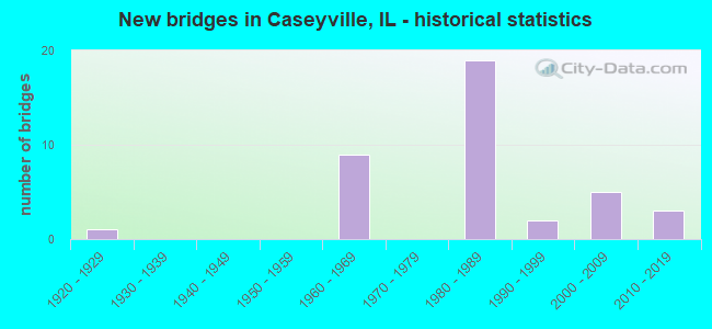
- New bridges - historical statistics
- 11920-1929
- 91960-1969
- 191980-1989
- 21990-1999
- 52000-2009
- 32010-2019

- Reconstructed bridges - Historical Statistics
- 62000-2009
- 02010-2019
- 12020-2022


- Bridge Condition - Deck
- 13.6%Very good
- 68.2%Good
- 13.6%Satisfactory
- 4.5%Poor

- Bridge Condition - Superstructure
- 18.2%Very good
- 40.9%Good
- 31.8%Satisfactory
- 4.5%Fair
- 4.5%Poor

- Bridge Condition - Substructure
- 36.4%Very good
- 40.9%Good
- 18.2%Satisfactory
- 4.5%Fair

- Bridge Condition - Channel
- 37.5%Very good
- 43.8%Good
- 18.8%Satisfactory
Find on map >> Show street view
Structure Number: 820123, Location: IN CASEYVILLE (Lat: 38.638636, Lng: -90.023236), Route carried "on" structure: State highway 157, Year Built: 1929, Status: Open, Structure Length: 0.98m (3.22ft), Average Daily Traffic: 9,450 (year 2021), Truck Traffic: 4%, Average Future Daily Traffic: 10,565 (year 2032), Features Intersected: LITTLE CANTEEN CREEK
Minimum Vertical Clearance: 30+ m (98+ ft), Kilometerpoint: 20.985, Lanes on structure: 2, Base Highway Network: Yes, Owner: State Highway Agency, Approaching Roadway Width: 11.1m (36.4ft), Material/Design: Concrete, Design/Construction: Slab, Number Of Spans In Main Unit: 1, Length of Maximum Span: 9.1m (29.9ft), Curb or Sidewalk Widths: Left: 1.5m (4.9ft), Right: 1.5m (4.9ft), Curb-To-Curb Width: 13.4m (44.0ft), Out-to-Out Width: 17.2m (56.4ft)
Condition: Deck: Poor, Superstructure: Poor, Substructure: Fair, Channel: Good, Operating Rating: 46.0 metric tons, Method Used To Determine Operating Rating: Load Factor (LF) rating reported by rating factor (RF) method using MS18 loading, Inventory Rating: 27.5 metric tons, Method Used To Determine Inventory Rating: Load Factor (LF) rating reported by rating factor (RF) method using MS18 loading, Structural Evaluation: Meets minimum limits, Deck Geometry: Equal to present minimum criteria, Waterway Adequacy: Equal to present minimum criteria, Approach Roadway Alignment: Equal to present desirable criteria, Designated Inspection Frequency: Every 12 months, Other Special Inspection Frequency: Every 12 months, Inspection Date: June 2021, Other Special Inspection Date: June 2021, Deck Structure Type: Concrete Cast-file-Place, Wearing Surface/Protective System: Wearing Surface: Bituminous
Find on map >> Show street view
Structure Number: 820167, Location: 0.67 MI E OF ILL 111 (Lat: 38.619078, Lng: -90.076211), Route carried "on" structure: Interstate 64, Year Built: 1968, Year Reconstructed: 2012, Status: Open, Structure Length: 7.89m (25.89ft), Average Daily Traffic: 39,500 (year 2021), Truck Traffic: 13%, Average Future Daily Traffic: 39,339 (year 2032), Design Load: HS 20, Features Intersected: ALTON & SOUTHERN RR
Minimum Vertical Clearance: 30+ m (98+ ft), Kilometerpoint: 10.621, Lanes on structure: 5, Base Highway Network: Yes, Owner: State Highway Agency, Approaching Roadway Width: 20.7m (67.9ft), Skew: 2 degrees, Material/Design: Steel continuous, Design/Construction: Stringer/Multi-beam, Number Of Spans In Main Unit: 3, Length of Maximum Span: 26.5m (86.9ft), Curb-To-Curb Width: 20.9m (68.6ft), Out-to-Out Width: 21.9m (71.9ft)
Condition: Deck: Good, Superstructure: Good, Substructure: Satisfactory, Operating Rating: 73.9 metric tons, Method Used To Determine Operating Rating: Load Factor (LF) rating reported by rating factor (RF) method using MS18 loading, Inventory Rating: 44.1 metric tons, Method Used To Determine Inventory Rating: Load Factor (LF) rating reported by rating factor (RF) method using MS18 loading, Structural Evaluation: Equal to present minimum criteria, Deck Geometry: Meets minimum limits, Underclear: Better than present minimum criteria, Approach Roadway Alignment: Equal to present desirable criteria, Designated Inspection Frequency: Every 24 months, Inspection Date: Febuary 2021, Deck Structure Type: Concrete Cast-file-Place, Wearing Surface/Protective System: Wearing Surface: Bituminous, Membrane: Built-up
Find on map >> Show street view
Structure Number: 820169, Location: 1.04 MI E OF ILL 111 (Lat: 38.618769, Lng: -90.072361), Route carried "on" structure: Interstate 64, Year Built: 1968, Year Reconstructed: 2012, Status: Open, Structure Length: 3.39m (11.12ft), Average Daily Traffic: 42,950 (year 2021), Truck Traffic: 13%, Average Future Daily Traffic: 35,782 (year 2032), Features Intersected: HARDING DITCH
Minimum Vertical Clearance: 30+ m (98+ ft), Kilometerpoint: 11.201, Lanes on structure: 8, Base Highway Network: Yes, Owner: State Highway Agency, Approaching Roadway Width: 40.4m (132.5ft), Skew: 1 degrees, Material/Design: Steel continuous, Design/Construction: Stringer/Multi-beam, Number Of Spans In Main Unit: 3, Length of Maximum Span: 12.4m (40.7ft), Curb-To-Curb Width: 40.4m (132.5ft), Out-to-Out Width: 41.9m (137.5ft)
Condition: Deck: Good, Superstructure: Satisfactory, Substructure: Satisfactory, Channel: Good, Operating Rating: 52.8 metric tons, Method Used To Determine Operating Rating: Load Factor (LF) rating reported by rating factor (RF) method using MS18 loading, Inventory Rating: 31.4 metric tons, Method Used To Determine Inventory Rating: Load Factor (LF) rating reported by rating factor (RF) method using MS18 loading, Structural Evaluation: Equal to present minimum criteria, Deck Geometry: Superior to present desirable criteria, Waterway Adequacy: Better than present minimum criteria, Approach Roadway Alignment: Equal to present desirable criteria, Designated Inspection Frequency: Every 24 months, Inspection Date: Febuary 2021, Deck Structure Type: Concrete Cast-file-Place, Wearing Surface/Protective System: Wearing Surface: Other
Find on map >> Show street view
Structure Number: 82017, Location: 1.05 MI E OF ILL 111 (Lat: 38.618769, Lng: -90.072264), Route carried "on" structure: Interstate 64, Year Built: 1968, Year Reconstructed: 2012, Status: Open, Structure Length: 3.39m (11.12ft), Average Daily Traffic: 41,250 (year 2021), Truck Traffic: 12%, Average Future Daily Traffic: 39,339 (year 2032), Features Intersected: HARDING DITCH
Minimum Vertical Clearance: 30+ m (98+ ft), Kilometerpoint: 11.217, Lanes on structure: 7, Base Highway Network: Yes, Owner: State Highway Agency, Approaching Roadway Width: 18.0m (59.1ft), Skew: 1 degrees, Material/Design: Steel continuous, Design/Construction: Stringer/Multi-beam, Number Of Spans In Main Unit: 3, Length of Maximum Span: 12.4m (40.7ft), Curb-To-Curb Width: 30.9m (101.4ft), Out-to-Out Width: 31.9m (104.7ft)
Condition: Deck: Good, Superstructure: Satisfactory, Substructure: Satisfactory, Channel: Good, Operating Rating: 60.3 metric tons, Method Used To Determine Operating Rating: Load Factor (LF) rating reported by rating factor (RF) method using MS18 loading, Inventory Rating: 36.3 metric tons, Method Used To Determine Inventory Rating: Load Factor (LF) rating reported by rating factor (RF) method using MS18 loading, Structural Evaluation: Equal to present minimum criteria, Deck Geometry: Equal to present minimum criteria, Waterway Adequacy: Better than present minimum criteria, Approach Roadway Alignment: Equal to present desirable criteria, Length Of Structure Improvement: 3.51m (11.52ft), Designated Inspection Frequency: Every 24 months, Inspection Date: Febuary 2021, Bridge Improvement Cost: $1,828,000, Roadway Improvement Cost: $182,000, Total Project Cost: $2,010,000, Deck Structure Type: Concrete Cast-file-Place, Wearing Surface/Protective System: Wearing Surface: Other
Find on map >> Show street view
Structure Number: 820239, Location: 0.5 MI N ST CLAIR AV (Lat: 38.612814, Lng: -90.075014), Route carried "on" structure: Interstate 255, Year Built: 1982, Status: Open, Structure Length: 8.27m (27.13ft), Average Daily Traffic: 23,900 (year 2021), Truck Traffic: 17%, Average Future Daily Traffic: 23,430 (year 2032), Design Load: HS 20, Features Intersected: HARDING DITCH south
Minimum Vertical Clearance: 30+ m (98+ ft), Kilometerpoint: 25.379, Lanes on structure: 3, Base Highway Network: Yes, Owner: State Highway Agency, Approaching Roadway Width: 17.1m (56.1ft), Skew: 5 degrees, Material/Design: Steel continuous, Design/Construction: Stringer/Multi-beam, Number Of Spans In Main Unit: 3, Length of Maximum Span: 31.5m (103.3ft), Curb-To-Curb Width: 17.1m (56.1ft), Out-to-Out Width: 18.0m (59.1ft)
Condition: Deck: Satisfactory, Superstructure: Satisfactory, Substructure: Good, Channel: Very good, Operating Rating: 81.6 metric tons, Method Used To Determine Operating Rating: Load Factor (LF) rating reported by rating factor (RF) method using MS18 loading, Inventory Rating: 44.7 metric tons, Method Used To Determine Inventory Rating: Load Factor (LF) rating reported by rating factor (RF) method using MS18 loading, Structural Evaluation: Equal to present minimum criteria, Deck Geometry: Equal to present minimum criteria, Waterway Adequacy: Superior to present desirable criteria, Approach Roadway Alignment: Equal to present desirable criteria, Designated Inspection Frequency: Every 24 months, Inspection Date: January 2021, Deck Structure Type: Concrete Cast-file-Place, Wearing Surface/Protective System: Wearing Surface: Bituminous, Membrane: Other, Deck Protection: Epoxy Coated Reinforcing
Find on map >> Show street view
Structure Number: 82024, Location: 0.5 M N STCLAIR AVE (Lat: 38.612986, Lng: -90.074706), Route carried "on" structure: Interstate 255, Year Built: 1982, Status: Open, Structure Length: 8.27m (27.13ft), Average Daily Traffic: 36,500 (year 2021), Truck Traffic: 17%, Average Future Daily Traffic: 35,259 (year 2032), Design Load: HS 20, Features Intersected: HARDING DITCH south
Minimum Vertical Clearance: 30+ m (98+ ft), Kilometerpoint: 25.411, Lanes on structure: 6, Base Highway Network: Yes, Owner: State Highway Agency, Approaching Roadway Width: 17.1m (56.1ft), Skew: 5 degrees, Material/Design: Steel continuous, Design/Construction: Stringer/Multi-beam, Number Of Spans In Main Unit: 3, Length of Maximum Span: 31.5m (103.3ft), Curb-To-Curb Width: 26.4m (86.6ft), Out-to-Out Width: 27.3m (89.6ft)
Condition: Deck: Satisfactory, Superstructure: Satisfactory, Substructure: Good, Channel: Very good, Operating Rating: 78.4 metric tons, Method Used To Determine Operating Rating: Load Factor (LF) rating reported by rating factor (RF) method using MS18 loading, Inventory Rating: 43.1 metric tons, Method Used To Determine Inventory Rating: Load Factor (LF) rating reported by rating factor (RF) method using MS18 loading, Structural Evaluation: Equal to present minimum criteria, Deck Geometry: Meets minimum limits, Waterway Adequacy: Superior to present desirable criteria, Approach Roadway Alignment: Equal to present desirable criteria, Designated Inspection Frequency: Every 24 months, Inspection Date: January 2021, Deck Structure Type: Concrete Cast-file-Place, Wearing Surface/Protective System: Wearing Surface: Bituminous, Membrane: Other, Deck Protection: Epoxy Coated Reinforcing
Find on map >> Show street view
Structure Number: 820241, Location: .75 MI SO BUNKUM RD (Lat: 38.618475, Lng: -90.068497), Route carried "on" structure: Interstate 255, Year Built: 1981, Year Reconstructed: 2013, Status: Open, Structure Length: 11.03m (36.19ft), Average Daily Traffic: 22,800 (year 2021), Truck Traffic: 18%, Average Future Daily Traffic: 28,669 (year 2032), Design Load: HS 20+Mod, Features Intersected: FAI 64
Minimum Vertical Clearance: 30+ m (98+ ft), Kilometerpoint: 26.296, Lanes on structure: 6, Lanes under structure: 18, Base Highway Network: Yes, Owner: State Highway Agency, Approaching Roadway Width: 31.7m (104.0ft), Skew: 2 degrees, Material/Design: Steel continuous, Design/Construction: Stringer/Multi-beam, Number Of Spans In Main Unit: 3, Length of Maximum Span: 47.5m (155.8ft), Curb-To-Curb Width: 32.9m (107.9ft), Out-to-Out Width: 33.9m (111.2ft)
Condition: Deck: Good, Superstructure: Satisfactory, Substructure: Good, Operating Rating: 76.1 metric tons, Method Used To Determine Operating Rating: Load Factor (LF) rating reported by rating factor (RF) method using MS18 loading, Inventory Rating: 45.7 metric tons, Method Used To Determine Inventory Rating: Load Factor (LF) rating reported by rating factor (RF) method using MS18 loading, Structural Evaluation: Equal to present minimum criteria, Deck Geometry: Superior to present desirable criteria, Underclear: Equal to present minimum criteria, Approach Roadway Alignment: Equal to present desirable criteria, Designated Inspection Frequency: Every 24 months, Inspection Date: January 2021, Deck Structure Type: Concrete Cast-file-Place, Wearing Surface/Protective System: Wearing Surface: Bituminous, Membrane: Built-up, Deck Protection: Epoxy Coated Reinforcing
Find on map >> Show street view
Structure Number: 820242, Location: .75 MI SO BUNKUM RD (Lat: 38.618353, Lng: -90.068564), Route carried "on" structure: Interstate 255, Year Built: 1981, Year Reconstructed: 2013, Status: Open, Structure Length: 11.09m (36.38ft), Average Daily Traffic: 34,300 (year 2021), Truck Traffic: 16%, Average Future Daily Traffic: 91,838 (year 2032), Design Load: HS 20+Mod, Features Intersected: FAI 64
Minimum Vertical Clearance: 30+ m (98+ ft), Kilometerpoint: 26.280, Lanes on structure: 6, Lanes under structure: 18, Base Highway Network: Yes, Owner: State Highway Agency, Approaching Roadway Width: 31.7m (104.0ft), Skew: 2 degrees, Material/Design: Steel continuous, Design/Construction: Stringer/Multi-beam, Number Of Spans In Main Unit: 3, Length of Maximum Span: 47.5m (155.8ft), Curb-To-Curb Width: 32.9m (107.9ft), Out-to-Out Width: 34.8m (114.2ft)
Condition: Deck: Good, Superstructure: Satisfactory, Substructure: Good, Operating Rating: 76.1 metric tons, Method Used To Determine Operating Rating: Load Factor (LF) rating reported by rating factor (RF) method using MS18 loading, Inventory Rating: 45.4 metric tons, Method Used To Determine Inventory Rating: Load Factor (LF) rating reported by rating factor (RF) method using MS18 loading, Structural Evaluation: Equal to present minimum criteria, Deck Geometry: Superior to present desirable criteria, Underclear: Equal to present minimum criteria, Approach Roadway Alignment: Equal to present desirable criteria, Designated Inspection Frequency: Every 24 months, Inspection Date: January 2021, Deck Structure Type: Concrete Cast-file-Place, Wearing Surface/Protective System: Wearing Surface: Bituminous, Membrane: Built-up, Deck Protection: Epoxy Coated Reinforcing
Find on map >> Show street view
Structure Number: 820243, Location: 0.2MI N OF FAI 64 (Lat: 38.622700, Lng: -90.067817), Route carried "on" structure: Other road , Year Built: 1985, Status: Open, Structure Length: 10.30m (33.79ft), Average Daily Traffic: 1,550 (year 2021), Truck Traffic: 19%, Average Future Daily Traffic: 1,203 (year 2032), Design Load: HS 20, Features Intersected: FAI 255, Facility Carried by Structure: BUNKUM RD/ FAU 916
Minimum Vertical Clearance: 30+ m (98+ ft), Kilometerpoint: 3.750, Lanes on structure: 2, Lanes under structure: 18, Owner: State Highway Agency, Approaching Roadway Width: 7.9m (25.9ft), Material/Design: Steel continuous, Design/Construction: Stringer/Multi-beam, Number Of Spans In Main Unit: 4, Length of Maximum Span: 26.2m (86.0ft), Curb-To-Curb Width: 12.3m (40.4ft), Out-to-Out Width: 13.2m (43.3ft)
Condition: Deck: Good, Superstructure: Good, Substructure: Very good, Operating Rating: 61.6 metric tons, Method Used To Determine Operating Rating: Load Factor (LF) rating reported by rating factor (RF) method using MS18 loading, Inventory Rating: 36.9 metric tons, Method Used To Determine Inventory Rating: Load Factor (LF) rating reported by rating factor (RF) method using MS18 loading, Structural Evaluation: Better than present minimum criteria, Deck Geometry: Better than present minimum criteria, Underclear: Somewhat better than minimum adequacy, Approach Roadway Alignment: Equal to present desirable criteria, Designated Inspection Frequency: Every 24 months, Inspection Date: January 2021, Deck Structure Type: Concrete Cast-file-Place, Wearing Surface/Protective System: Wearing Surface: Bituminous, Membrane: Built-up, Deck Protection: Epoxy Coated Reinforcing
Find on map >> Show street view
Structure Number: 820244, Location: 1.4MI N FAI 64 (Lat: 38.636939, Lng: -90.057161), Route carried "on" structure: Other road , Year Built: 1985, Status: Open, Structure Length: 16.95m (55.61ft), Average Daily Traffic: 525 (year 2021), Truck Traffic: 7%, Average Future Daily Traffic: 785 (year 2032), Design Load: HS 20+Mod, Features Intersected: FAI 255/HARDING DITH, Facility Carried by Structure: FOREST BLVD/FAU 91
Minimum Vertical Clearance: 30+ m (98+ ft), Kilometerpoint: 4.329, Lanes on structure: 2, Lanes under structure: 6, Owner: State Highway Agency, Approaching Roadway Width: 7.9m (25.9ft), Skew: 4 degrees, Material/Design: Steel continuous, Design/Construction: Stringer/Multi-beam, Number Of Spans In Main Unit: 3, Number Of Approach Spans: 2, Length of Maximum Span: 60.0m (196.9ft), Curb-To-Curb Width: 12.2m (40.0ft), Out-to-Out Width: 13.2m (43.3ft)
Condition: Deck: Good, Superstructure: Good, Substructure: Good, Channel: Very good, Operating Rating: 61.6 metric tons, Method Used To Determine Operating Rating: Load Factor (LF) rating reported by rating factor (RF) method using MS18 loading, Inventory Rating: 36.9 metric tons, Method Used To Determine Inventory Rating: Load Factor (LF) rating reported by rating factor (RF) method using MS18 loading, Structural Evaluation: Better than present minimum criteria, Deck Geometry: Equal to present desirable criteria, Underclear: Somewhat better than minimum adequacy, Waterway Adequacy: Superior to present desirable criteria, Approach Roadway Alignment: Equal to present desirable criteria, Designated Inspection Frequency: Every 24 months, Inspection Date: January 2021, Deck Structure Type: Concrete Cast-file-Place, Wearing Surface/Protective System: Wearing Surface: Bituminous, Membrane: Built-up, Deck Protection: Epoxy Coated Reinforcing
Find on map >> Show street view
Structure Number: 820245, Location: 1.9MI N FAI 64 (Lat: 38.640072, Lng: -90.052481), Route carried "on" structure: Interstate 255, Year Built: 1985, Status: Open, Structure Length: 10.58m (34.71ft), Average Daily Traffic: 21,700 (year 2021), Truck Traffic: 15%, Average Future Daily Traffic: 24,215 (year 2032), Design Load: HS 20+Mod, Features Intersected: HARDING DITCH north
Minimum Vertical Clearance: 30+ m (98+ ft), Kilometerpoint: 29.177, Lanes on structure: 3, Base Highway Network: Yes, Owner: State Highway Agency, Approaching Roadway Width: 17.1m (56.1ft), Skew: 4 degrees, Material/Design: Steel continuous, Design/Construction: Stringer/Multi-beam, Number Of Spans In Main Unit: 3, Length of Maximum Span: 34.4m (112.9ft), Curb-To-Curb Width: 17.1m (56.1ft), Out-to-Out Width: 18.0m (59.1ft)
Condition: Deck: Good, Superstructure: Fair, Substructure: Satisfactory, Channel: Good, Operating Rating: 83.6 metric tons, Method Used To Determine Operating Rating: Load Factor (LF) rating reported by rating factor (RF) method using MS18 loading, Inventory Rating: 50.2 metric tons, Method Used To Determine Inventory Rating: Load Factor (LF) rating reported by rating factor (RF) method using MS18 loading, Structural Evaluation: Somewhat better than minimum adequacy, Deck Geometry: Equal to present minimum criteria, Waterway Adequacy: Superior to present desirable criteria, Approach Roadway Alignment: Equal to present desirable criteria, Designated Inspection Frequency: Every 24 months, Inspection Date: January 2021, Deck Structure Type: Concrete Cast-file-Place, Wearing Surface/Protective System: Wearing Surface: Bituminous, Membrane: Other, Deck Protection: Epoxy Coated Reinforcing
Find on map >> Show street view
Structure Number: 820246, Location: 1.9MI N FAI 64 (Lat: 38.640167, Lng: -90.052342), Route carried "on" structure: Interstate 255, Year Built: 1985, Year Reconstructed: 2020, Status: Open, Structure Length: 10.45m (34.28ft), Average Daily Traffic: 21,700 (year 2021), Truck Traffic: 15%, Average Future Daily Traffic: 24,215 (year 2032), Design Load: HS 20+Mod, Features Intersected: HARDING DITCH north
Minimum Vertical Clearance: 30+ m (98+ ft), Kilometerpoint: 29.193, Lanes on structure: 3, Base Highway Network: Yes, Owner: State Highway Agency, Approaching Roadway Width: 17.1m (56.1ft), Skew: 4 degrees, Material/Design: Steel continuous, Design/Construction: Stringer/Multi-beam, Number Of Spans In Main Unit: 3, Length of Maximum Span: 34.4m (112.9ft), Curb-To-Curb Width: 17.1m (56.1ft), Out-to-Out Width: 18.0m (59.1ft)
Condition: Deck: Very good, Superstructure: Good, Substructure: Good, Channel: Good, Operating Rating: 82.6 metric tons, Method Used To Determine Operating Rating: Load Factor (LF) rating reported by rating factor (RF) method using MS18 loading, Inventory Rating: 43.4 metric tons, Method Used To Determine Inventory Rating: Load Factor (LF) rating reported by rating factor (RF) method using MS18 loading, Structural Evaluation: Better than present minimum criteria, Deck Geometry: Equal to present minimum criteria, Waterway Adequacy: Superior to present desirable criteria, Approach Roadway Alignment: Equal to present desirable criteria, Designated Inspection Frequency: Every 24 months, Inspection Date: January 2021, Deck Structure Type: Concrete Cast-file-Place, Wearing Surface/Protective System: Deck Protection: Epoxy Coated Reinforcing
Find on map >> Show street view
Structure Number: 820247, Location: 1M S MADISON CO LINE (Lat: 38.643764, Lng: -90.046892), Route carried "on" structure: Interstate 255, Year Built: 1985, Status: Open, Structure Length: 60.35m (198.00ft), Average Daily Traffic: 21,700 (year 2021), Truck Traffic: 15%, Average Future Daily Traffic: 24,215 (year 2032), Design Load: HS 20+Mod, Features Intersected: BLACK LN-B&O-CONRAIL
Minimum Vertical Clearance: 30+ m (98+ ft), Kilometerpoint: 29.820, Lanes on structure: 3, Lanes under structure: 2, Base Highway Network: Yes, Owner: State Highway Agency, Approaching Roadway Width: 17.1m (56.1ft), Skew: 3 degrees, Material/Design: Steel continuous, Design/Construction: Stringer/Multi-beam, Number Of Spans In Main Unit: 19, Length of Maximum Span: 40.2m (131.9ft), Curb-To-Curb Width: 17.1m (56.1ft), Out-to-Out Width: 18.0m (59.1ft)
Condition: Deck: Good, Superstructure: Good, Substructure: Good, Operating Rating: 70.3 metric tons, Method Used To Determine Operating Rating: Load Factor (LF) rating reported by rating factor (RF) method using MS18 loading, Inventory Rating: 34.3 metric tons, Method Used To Determine Inventory Rating: Load Factor (LF) rating reported by rating factor (RF) method using MS18 loading, Structural Evaluation: Better than present minimum criteria, Deck Geometry: Equal to present minimum criteria, Underclear: Superior to present desirable criteria, Approach Roadway Alignment: Equal to present desirable criteria, Designated Inspection Frequency: Every 24 months, Inspection Date: January 2021, Deck Structure Type: Concrete Cast-file-Place, Wearing Surface/Protective System: Wearing Surface: Bituminous, Membrane: Built-up, Deck Protection: Epoxy Coated Reinforcing
Find on map >> Show street view
Structure Number: 820261, Location: 1 MI WEST OF ILL 157 (Lat: 38.619092, Lng: -90.060289), Route carried "on" structure: County highway , Year Built: 1969, Year Reconstructed: 2012, Status: Open, Structure Length: 8.24m (27.03ft), Average Daily Traffic: 200 (year 2018), Truck Traffic: 5%, Average Future Daily Traffic: 314 (year 2032), Design Load: HS 20, Features Intersected: FAI 64/CD 360-361, Facility Carried by Structure: 81ST ST/CH35
Minimum Vertical Clearance: 5.05m (16.57ft), Kilometerpoint: 0.370, Lanes on structure: 2, Lanes under structure: 18, Owner: State Highway Agency, Approaching Roadway Width: 12.2m (40.0ft), Material/Design: Steel continuous, Design/Construction: Stringer/Multi-beam, Number Of Spans In Main Unit: 2, Number Of Approach Spans: 2, Length of Maximum Span: 43.3m (142.1ft), Curb-To-Curb Width: 12.2m (40.0ft), Out-to-Out Width: 13.1m (43.0ft)
Condition: Deck: Satisfactory, Superstructure: Satisfactory, Substructure: Good, Operating Rating: 60.3 metric tons, Method Used To Determine Operating Rating: Load Factor (LF) rating reported by rating factor (RF) method using MS18 loading, Inventory Rating: 36.3 metric tons, Method Used To Determine Inventory Rating: Load Factor (LF) rating reported by rating factor (RF) method using MS18 loading, Structural Evaluation: Equal to present minimum criteria, Deck Geometry: Superior to present desirable criteria, Underclear: Equal to present minimum criteria, Approach Roadway Alignment: Equal to present desirable criteria, Designated Inspection Frequency: Every 24 months, Inspection Date: Febuary 2021, Deck Structure Type: Concrete Cast-file-Place, Wearing Surface/Protective System: Wearing Surface: Bituminous, Membrane: Built-up, Deck Protection: Epoxy Coated Reinforcing
Find on map >> Show street view
Structure Number: 820279, Location: IN CASEYVILLE (Lat: 38.642575, Lng: -90.018689), Route carried "on" structure: State highway 157, Year Built: 1990, Status: Open, Structure Length: 7.18m (23.56ft), Average Daily Traffic: 10,400 (year 2021), Truck Traffic: 4%, Average Future Daily Traffic: 11,924 (year 2032), Design Load: HS 20, Features Intersected: CONRAIL RR
Minimum Vertical Clearance: 30+ m (98+ ft), Kilometerpoint: 21.581, Lanes on structure: 2, Base Highway Network: Yes, Owner: State Highway Agency, Approaching Roadway Width: 7.3m (24.0ft), Skew: 4 degrees, Material/Design: Steel continuous, Design/Construction: Stringer/Multi-beam, Number Of Spans In Main Unit: 3, Length of Maximum Span: 23.9m (78.4ft), Curb-To-Curb Width: 12.2m (40.0ft), Out-to-Out Width: 13.2m (43.3ft)
Condition: Deck: Good, Superstructure: Good, Substructure: Very good, Operating Rating: 84.9 metric tons, Method Used To Determine Operating Rating: Load Factor (LF) rating reported by rating factor (RF) method using MS18 loading, Inventory Rating: 48.3 metric tons, Method Used To Determine Inventory Rating: Load Factor (LF) rating reported by rating factor (RF) method using MS18 loading, Structural Evaluation: Better than present minimum criteria, Deck Geometry: Somewhat better than minimum adequacy, Underclear: Superior to present desirable criteria, Approach Roadway Alignment: Equal to present desirable criteria, Designated Inspection Frequency: Every 48 months, Inspection Date: June 2021, Deck Structure Type: Concrete Cast-file-Place, Wearing Surface/Protective System: Deck Protection: Epoxy Coated Reinforcing
Find on map >> Show street view
Structure Number: 820286, Location: N C LMTS CASEYVILLE (Lat: 38.643439, Lng: -90.017739), Route carried "on" structure: State highway 157, Year Built: 1990, Status: Open, Structure Length: 5.17m (16.96ft), Average Daily Traffic: 10,400 (year 2021), Truck Traffic: 4%, Average Future Daily Traffic: 11,924 (year 2032), Design Load: HS 20, Features Intersected: CANTEEN CREEK
Minimum Vertical Clearance: 30+ m (98+ ft), Kilometerpoint: 21.726, Lanes on structure: 2, Base Highway Network: Yes, Owner: State Highway Agency, Approaching Roadway Width: 8.8m (28.9ft), Material/Design: Steel continuous, Design/Construction: Stringer/Multi-beam, Number Of Spans In Main Unit: 3, Length of Maximum Span: 18.9m (62.0ft), Curb-To-Curb Width: 12.2m (40.0ft), Out-to-Out Width: 13.2m (43.3ft)
Condition: Deck: Good, Superstructure: Good, Substructure: Good, Channel: Good, Operating Rating: 63.8 metric tons, Method Used To Determine Operating Rating: Load Factor (LF) rating reported by rating factor (RF) method using MS18 loading, Inventory Rating: 37.9 metric tons, Method Used To Determine Inventory Rating: Load Factor (LF) rating reported by rating factor (RF) method using MS18 loading, Structural Evaluation: Better than present minimum criteria, Deck Geometry: Somewhat better than minimum adequacy, Waterway Adequacy: Superior to present desirable criteria, Approach Roadway Alignment: Equal to present minimum criteria, Designated Inspection Frequency: Every 48 months, Inspection Date: June 2021, Deck Structure Type: Concrete Cast-file-Place, Wearing Surface/Protective System: Deck Protection: Epoxy Coated Reinforcing
Find on map >> Show street view
Structure Number: 820307, Location: CASEYVILLE (Lat: 38.614319, Lng: -90.046031), Route carried "on" structure: Interstate 64, Year Built: 2007, Status: Open, Structure Length: 5.36m (17.59ft), Average Daily Traffic: 244,200 (year 2021), Truck Traffic: 2%, Average Future Daily Traffic: 40,533 (year 2032), Design Load: HS 20, Features Intersected: ILL 157
Minimum Vertical Clearance: 30+ m (98+ ft), Kilometerpoint: 13.824, Lanes on structure: 3, Lanes under structure: 5, Base Highway Network: Yes, Owner: State Highway Agency, Approaching Roadway Width: 22.3m (73.2ft), Material/Design: Steel continuous, Design/Construction: Stringer/Multi-beam, Number Of Spans In Main Unit: 2, Length of Maximum Span: 28.3m (92.8ft), Curb-To-Curb Width: 21.3m (69.9ft), Out-to-Out Width: 22.3m (73.2ft)
Condition: Deck: Good, Superstructure: Very good, Substructure: Very good, Operating Rating: 69.3 metric tons, Method Used To Determine Operating Rating: Load Factor (LF) rating reported by rating factor (RF) method using MS18 loading, Inventory Rating: 41.8 metric tons, Method Used To Determine Inventory Rating: Load Factor (LF) rating reported by rating factor (RF) method using MS18 loading, Structural Evaluation: Equal to present desirable criteria, Deck Geometry: Superior to present desirable criteria, Underclear: High priority of corrective action, Approach Roadway Alignment: Equal to present desirable criteria, Designated Inspection Frequency: Every 24 months, Inspection Date: Febuary 2021, Deck Structure Type: Concrete Cast-file-Place, Wearing Surface/Protective System: Deck Protection: Epoxy Coated Reinforcing
Find on map >> Show street view
Structure Number: 822012, Location: 0.08 S BUNKUM RD (Lat: 38.619836, Lng: -90.040606), Route carried "on" structure: State highway 157, Year Built: 1966, Status: Open, Structure Length: 0.79m (2.59ft), Average Daily Traffic: 10,300 (year 2021), Truck Traffic: 9%, Average Future Daily Traffic: 12,447 (year 2032), Design Load: HS 20, Features Intersected: Trib to Harding Dtch
Minimum Vertical Clearance: 30+ m (98+ ft), Kilometerpoint: 18.378, Lanes on structure: 4, Base Highway Network: Yes, Owner: State Highway Agency, Approaching Roadway Width: 14.6m (47.9ft), Skew: 10 degrees, Material/Design: Steel, Design/Construction: Culvert, Number Of Spans In Main Unit: 2, Length of Maximum Span: 3.5m (11.5ft)
Condition: Channel: Satisfactory, Culverts: Satisfactory, Operating Rating: 97.2 metric tons, Method Used To Determine Operating Rating: Load Factor (LF) rating reported by rating factor (RF) method using MS18 loading, Inventory Rating: 70.0 metric tons, Method Used To Determine Inventory Rating: Load Factor (LF) rating reported by rating factor (RF) method using MS18 loading, Structural Evaluation: Equal to present minimum criteria, Waterway Adequacy: Better than present minimum criteria, Approach Roadway Alignment: Equal to present desirable criteria, Designated Inspection Frequency: Every 24 months, Inspection Date: June 2021
Find on map >> Show street view
Structure Number: 823001, Location: 0.25MI W ILL 157 (Lat: 38.622292, Lng: -90.046703), Route carried "on" structure: Other road , Year Built: 1960, Status: Open, Structure Length: 1.33m (4.36ft), Average Daily Traffic: 1,900 (year 2021), Truck Traffic: 14%, Average Future Daily Traffic: 1,046 (year 2032), Design Load: HS 20, Features Intersected: DITCH, Facility Carried by Structure: BUNKUM RD/ FAU 916
Minimum Vertical Clearance: 30+ m (98+ ft), Kilometerpoint: 5.665, Lanes on structure: 2, Owner: County Highway Agency, Approaching Roadway Width: 11.0m (36.1ft), Skew: 6 degrees, Material/Design: Concrete, Design/Construction: Culvert, Number Of Spans In Main Unit: 2, Length of Maximum Span: 6.4m (21.0ft)
Condition: Channel: Satisfactory, Culverts: Satisfactory, Operating Rating: 32.7 metric tons, Method Used To Determine Operating Rating: Load Factor (LF) rating reported by rating factor (RF) method using MS18 loading, Inventory Rating: 19.4 metric tons, Method Used To Determine Inventory Rating: Load Factor (LF) rating reported by rating factor (RF) method using MS18 loading, Structural Evaluation: Somewhat better than minimum adequacy, Waterway Adequacy: Better than present minimum criteria, Approach Roadway Alignment: Equal to present desirable criteria, Designated Inspection Frequency: Every 24 months, Inspection Date: Febuary 2020
Find on map >> Show street view
Structure Number: 8231, Location: 1 MI E IL 111 (Lat: 38.622667, Lng: -90.075072), Route carried "on" structure: Other road , Year Built: 2008, Status: Open, Structure Length: 2.49m (8.17ft), Average Daily Traffic: 1,550 (year 2021), Truck Traffic: 19%, Average Future Daily Traffic: 941 (year 2032), Design Load: HS 20, Features Intersected: HARDING DITCH, Facility Carried by Structure: BUNKUM RD/FAU 9160
Minimum Vertical Clearance: 30+ m (98+ ft), Kilometerpoint: 3.154, Lanes on structure: 2, Owner: County Highway Agency, Approaching Roadway Width: 12.2m (40.0ft), Skew: 1 degrees, Material/Design: Prestressed concrete, Design/Construction: Box Beam or Girders - Multiple, Number Of Spans In Main Unit: 1, Length of Maximum Span: 24.1m (79.1ft), Curb-To-Curb Width: 10.1m (33.1ft), Out-to-Out Width: 10.1m (33.1ft)
Condition: Deck: Very good, Superstructure: Very good, Substructure: Very good, Channel: Very good, Operating Rating: 67.4 metric tons, Method Used To Determine Operating Rating: Load Factor (LF) rating reported by rating factor (RF) method using MS18 loading, Inventory Rating: 40.5 metric tons, Method Used To Determine Inventory Rating: Load Factor (LF) rating reported by rating factor (RF) method using MS18 loading, Structural Evaluation: Equal to present desirable criteria, Deck Geometry: Somewhat better than minimum adequacy, Waterway Adequacy: Equal to present desirable criteria, Approach Roadway Alignment: Equal to present desirable criteria, Designated Inspection Frequency: Every 48 months, Inspection Date: March 2018, Deck Structure Type: Concrete Precast Panels, Wearing Surface/Protective System: Wearing Surface: Bituminous, Membrane: Built-up
Find on map >> Show street view
Structure Number: 823103, Location: 1.5MI E ILL RT 157 (Lat: 38.622344, Lng: -90.008103), Route carried "on" structure: County highway , Year Built: 2009, Status: Open, Structure Length: 2.79m (9.15ft), Average Daily Traffic: 225 (year 2018), Truck Traffic: 11%, Average Future Daily Traffic: 157 (year 2032), Design Load: HS 20, Features Intersected: LITTLE CANTEEN CREEK, Facility Carried by Structure: CIRCLE DR/CH 83
Minimum Vertical Clearance: 30+ m (98+ ft), Kilometerpoint: 2.527, Lanes on structure: 2, Owner: County Highway Agency, Approaching Roadway Width: 6.7m (22.0ft), Material/Design: Prestressed concrete, Design/Construction: Box Beam or Girders - Multiple, Number Of Spans In Main Unit: 3, Length of Maximum Span: 12.2m (40.0ft), Curb-To-Curb Width: 9.2m (30.2ft), Out-to-Out Width: 9.2m (30.2ft)
Condition: Deck: Good, Superstructure: Good, Substructure: Very good, Channel: Good, Operating Rating: 44.1 metric tons, Method Used To Determine Operating Rating: Assigned rating based on Load Factor Design (LFD) reported by rating factor (RF) using MS18 loading, Inventory Rating: 32.4 metric tons, Method Used To Determine Inventory Rating: Assigned rating based on Load Factor Design (LFD) reported by rating factor (RF) using MS18 loading, Structural Evaluation: Better than present minimum criteria, Deck Geometry: Equal to present minimum criteria, Waterway Adequacy: Equal to present desirable criteria, Approach Roadway Alignment: Better than present minimum criteria, Designated Inspection Frequency: Every 48 months, Inspection Date: Febuary 2019, Deck Structure Type: Concrete Precast Panels, Wearing Surface/Protective System: Wearing Surface: Bituminous, Membrane: Built-up
Find on map >> Show street view
Structure Number: 823104, Location: 1.5 MI W OF RT. 159 (Lat: 38.622767, Lng: -90.004478), Route carried "on" structure: Other road , Year Built: 2011, Status: Open, Structure Length: 2.06m (6.76ft), Average Daily Traffic: 1,000 (year 2021), Truck Traffic: 4%, Average Future Daily Traffic: 941 (year 2032), Design Load: HS 25 or greater, Features Intersected: LITTLE CANTEEN CREEK, Facility Carried by Structure: EAST O'FALLON DR.
Minimum Vertical Clearance: 30+ m (98+ ft), Kilometerpoint: 2.784, Lanes on structure: 2, Owner: County Highway Agency, Approaching Roadway Width: 9.8m (32.2ft), Material/Design: Prestressed concrete, Design/Construction: Box Beam or Girders - Multiple, Number Of Spans In Main Unit: 1, Length of Maximum Span: 19.6m (64.3ft), Curb-To-Curb Width: 9.8m (32.2ft), Out-to-Out Width: 9.8m (32.2ft)
Condition: Deck: Very good, Superstructure: Very good, Substructure: Very good, Channel: Very good, Operating Rating: 44.1 metric tons, Method Used To Determine Operating Rating: Assigned rating based on Load Factor Design (LFD) reported by rating factor (RF) using MS18 loading, Inventory Rating: 32.4 metric tons, Method Used To Determine Inventory Rating: Assigned rating based on Load Factor Design (LFD) reported by rating factor (RF) using MS18 loading, Structural Evaluation: Equal to present desirable criteria, Deck Geometry: Equal to present minimum criteria, Waterway Adequacy: Equal to present desirable criteria, Approach Roadway Alignment: Equal to present desirable criteria, Designated Inspection Frequency: Every 48 months, Inspection Date: Febuary 2018, Deck Structure Type: Concrete Precast Panels, Wearing Surface/Protective System: Wearing Surface: Bituminous, Membrane: Built-up
Find on map >> Show street view
Structure Number: 823109, Location: 1.25 mi. N of Bunkum (Lat: 38.640283, Lng: -90.046908), Route carried "on" structure: Other road , Year Built: 2013, Status: Open, Structure Length: 2.50m (8.20ft), Average Daily Traffic: 2,300 (year 2018), Truck Traffic: 7%, Average Future Daily Traffic: 3,200 (year 2033), Design Load: HS 25 or greater, Features Intersected: Harding Ditch, Facility Carried by Structure: Black Lane
Minimum Vertical Clearance: 30+ m (98+ ft), Kilometerpoint: 2.028, Lanes on structure: 2, Owner: County Highway Agency, Approaching Roadway Width: 9.1m (29.9ft), Material/Design: Prestressed concrete, Design/Construction: Box Beam or Girders - Multiple, Number Of Spans In Main Unit: 1, Length of Maximum Span: 0.0m, Curb-To-Curb Width: 12.3m (40.4ft), Out-to-Out Width: 12.3m (40.4ft)
Condition: Deck: Good, Superstructure: Good, Substructure: Very good, Channel: Very good, Operating Rating: 42.1 metric tons, Method Used To Determine Operating Rating: Assigned ratings based on Load and Resistance Factor Design (LRFD) reported by rating factor (RF) using HL93 loadings, Inventory Rating: 32.4 metric tons, Method Used To Determine Inventory Rating: Assigned ratings based on Load and Resistance Factor Design (LRFD) reported by rating factor (RF) using HL93 loadings, Structural Evaluation: Better than present minimum criteria, Deck Geometry: Equal to present minimum criteria, Waterway Adequacy: Equal to present desirable criteria, Approach Roadway Alignment: Equal to present desirable criteria, Designated Inspection Frequency: Every 48 months, Inspection Date: Febuary 2019, Deck Structure Type: Open Grating, Wearing Surface/Protective System: Wearing Surface: Bituminous, Membrane: Built-up
Find on map >> Show street view
Structure Number: 826201, Location: E Sec 7 T2N R8W (Lat: 38.639136, Lng: -90.024203), Route carried "on" structure: City street , Year Built: 2016, Status: Open, Structure Length: 1.98m (6.50ft), Average Daily Traffic: 800 (year 2018), Truck Traffic: 6%, Average Future Daily Traffic: 1,400 (year 2035), Design Load: HS 25 or greater, Features Intersected: Little Canteen Creek, Facility Carried by Structure: North Long Street
Minimum Vertical Clearance: 30+ m (98+ ft), Kilometerpoint: 0.483, Lanes on structure: 2, Owner: City or Municipal Highway Agency, Approaching Roadway Width: 7.9m (25.9ft), Skew: 1 degrees, Material/Design: Prestressed concrete, Design/Construction: Box Beam or Girders - Multiple, Number Of Spans In Main Unit: 1, Length of Maximum Span: 18.8m (61.7ft), Curb or Sidewalk Widths: Left: 1.8m (5.9ft), Right: 1.8m (5.9ft), Curb-To-Curb Width: 7.9m (25.9ft), Out-to-Out Width: 12.2m (40.0ft)
Condition: Deck: Good, Superstructure: Very good, Substructure: Very good, Channel: Satisfactory, Operating Rating: 42.1 metric tons, Method Used To Determine Operating Rating: Assigned ratings based on Load and Resistance Factor Design (LRFD) reported by rating factor (RF) using HL93 loadings, Inventory Rating: 32.4 metric tons, Method Used To Determine Inventory Rating: Assigned ratings based on Load and Resistance Factor Design (LRFD) reported by rating factor (RF) using HL93 loadings, Structural Evaluation: Equal to present desirable criteria, Deck Geometry: Somewhat better than minimum adequacy, Waterway Adequacy: Better than present minimum criteria, Approach Roadway Alignment: Equal to present desirable criteria, Designated Inspection Frequency: Every 48 months, Inspection Date: November 2018, Deck Structure Type: Concrete Precast Panels, Wearing Surface/Protective System: Wearing Surface: Integral Concrete, Deck Protection: Epoxy Coated Reinforcing
Find on map >> Show street view
Structure Number: 820241, Location: .75 MI SO BUNKUM RD (Lat: 38.618611, Lng: -90.068200), Route carried "under" structure: Other road , Year Built: 1981, Structure Length: 0. m, Average Daily Traffic: 16,500 (year 2018), Truck Traffic: 11%, Features Intersected: FAI 64, Facility Carried by Structure: FAI 255 NB
Minimum Vertical Clearance: 5.26m (17.26ft), Kilometerpoint: 1.738, Lanes on structure: 6, Lanes under structure: 6, Material/Design: Steel continuous, Design/Construction: Stringer/Multi-beam, Length of Maximum Span: 47.5m (155.8ft)
Find on map >> Show street view
Structure Number: 820241, Location: .75 MI SO BUNKUM RD (Lat: 38.618719, Lng: -90.068361), Route carried "under" structure: Interstate 64, Year Built: 1981, Structure Length: 0. m, Average Daily Traffic: 83,400 (year 2021), Truck Traffic: 14%, Features Intersected: FAI 64, Facility Carried by Structure: FAI 255 NB
Minimum Vertical Clearance: 5.26m (17.26ft), Kilometerpoint: 11.764, Lanes on structure: 6, Lanes under structure: 6, Material/Design: Steel continuous, Design/Construction: Stringer/Multi-beam, Length of Maximum Span: 47.5m (155.8ft)
Find on map >> Show street view
Structure Number: 820241, Location: .75 MI SO BUNKUM RD (Lat: 38.619081, Lng: -90.067978), Route carried "under" structure: Other road , Year Built: 1981, Structure Length: 0. m, Average Daily Traffic: 5,200 (year 2018), Truck Traffic: 9%, Features Intersected: FAI 64, Facility Carried by Structure: FAI 255 NB
Minimum Vertical Clearance: 5.26m (17.26ft), Kilometerpoint: 1.448, Lanes on structure: 6, Lanes under structure: 6, Material/Design: Steel continuous, Design/Construction: Stringer/Multi-beam, Length of Maximum Span: 47.5m (155.8ft)
Find on map >> Show street view
Structure Number: 820242, Location: .75 MI SO BUNKUM RD (Lat: 38.618600, Lng: -90.068989), Route carried "under" structure: Other road , Year Built: 1981, Structure Length: 0. m, Average Daily Traffic: 6,900 (year 2018), Truck Traffic: 12%, Features Intersected: FAI 64, Facility Carried by Structure: FAI 255 SB
Minimum Vertical Clearance: 5.23m (17.16ft), Kilometerpoint: 1.690, Lanes on structure: 6, Lanes under structure: 6, Material/Design: Steel continuous, Design/Construction: Stringer/Multi-beam, Length of Maximum Span: 47.5m (155.8ft)
Find on map >> Show street view
Structure Number: 820242, Location: .75 MI SO BUNKUM RD (Lat: 38.619078, Lng: -90.068742), Route carried "under" structure: Other road , Year Built: 1981, Structure Length: 0. m, Average Daily Traffic: 5,200 (year 2018), Truck Traffic: 9%, Features Intersected: FAI 64, Facility Carried by Structure: FAI 255 SB
Minimum Vertical Clearance: 5.23m (17.16ft), Kilometerpoint: 1.497, Lanes on structure: 6, Lanes under structure: 6, Material/Design: Steel continuous, Design/Construction: Stringer/Multi-beam, Length of Maximum Span: 47.5m (155.8ft)
Find on map >> Show street view
Structure Number: 820242, Location: .75 MI SO BUNKUM RD (Lat: 38.618728, Lng: -90.068739), Route carried "under" structure: Interstate 64, Year Built: 1981, Structure Length: 0. m, Average Daily Traffic: 83,400 (year 2021), Truck Traffic: 14%, Features Intersected: FAI 64, Facility Carried by Structure: FAI 255 SB
Minimum Vertical Clearance: 5.23m (17.16ft), Kilometerpoint: 11.732, Lanes on structure: 6, Lanes under structure: 6, Material/Design: Steel continuous, Design/Construction: Stringer/Multi-beam, Length of Maximum Span: 47.5m (155.8ft)
Find on map >> Show street view
Structure Number: 820243, Location: 0.2MI N OF FAI 64 (Lat: 38.622172, Lng: -90.067392), Route carried "under" structure: Interstate 255, Year Built: 1985, Structure Length: 0. m, Average Daily Traffic: 43,400 (year 2021), Truck Traffic: 15%, Features Intersected: FAI 255, Facility Carried by Structure: BUNKUM RD/ FAU 916
Minimum Vertical Clearance: 5.21m (17.09ft), Kilometerpoint: 26.730, Lanes on structure: 2, Lanes under structure: 6, Material/Design: Steel continuous, Design/Construction: Stringer/Multi-beam, Length of Maximum Span: 26.2m (86.0ft)
Find on map >> Show street view
Structure Number: 820243, Location: 0.2MI N OF FAI 64 (Lat: 38.622700, Lng: -90.067189), Route carried "under" structure: Other road , Year Built: 1985, Structure Length: 0. m, Average Daily Traffic: 1,100 (year 2018), Truck Traffic: 86%, Features Intersected: FAI 255, Facility Carried by Structure: BUNKUM RD/ FAU 916
Minimum Vertical Clearance: 5.21m (17.09ft), Kilometerpoint: 1.352, Lanes on structure: 2, Lanes under structure: 6, Material/Design: Steel continuous, Design/Construction: Stringer/Multi-beam, Length of Maximum Span: 26.2m (86.0ft)
Find on map >> Show street view
Structure Number: 820243, Location: 0.2MI N OF FAI 64 (Lat: 38.622700, Lng: -90.067817), Route carried "under" structure: Other road , Year Built: 1985, Structure Length: 0. m, Average Daily Traffic: 10,100 (year 2018), Truck Traffic: 9%, Features Intersected: FAI 255, Facility Carried by Structure: BUNKUM RD/ FAU 916
Minimum Vertical Clearance: 5.21m (17.09ft), Kilometerpoint: 1.641, Lanes on structure: 2, Lanes under structure: 6, Material/Design: Steel continuous, Design/Construction: Stringer/Multi-beam, Length of Maximum Span: 26.2m (86.0ft)
Find on map >> Show street view
Structure Number: 820244, Location: 1.4MI N FAI 64 (Lat: 38.636939, Lng: -90.057161), Route carried "under" structure: Interstate 255, Year Built: 1985, Structure Length: 0. m, Average Daily Traffic: 43,400 (year 2021), Truck Traffic: 15%, Features Intersected: FAI 255/HARDING DITH, Facility Carried by Structure: FOREST BLVD/FAU 91
Minimum Vertical Clearance: 5.05m (16.57ft), Kilometerpoint: 28.629, Lanes on structure: 2, Lanes under structure: 6, Material/Design: Steel continuous, Design/Construction: Stringer/Multi-beam, Length of Maximum Span: 60.0m (196.9ft)
Find on map >> Show street view
Structure Number: 820261, Location: 1 MI WEST OF ILL 157 (Lat: 38.618950, Lng: -90.060289), Route carried "under" structure: Other road , Year Built: 1969, Structure Length: 0. m, Average Daily Traffic: 18,000 (year 2018), Truck Traffic: 10%, Features Intersected: FAI 64/CD 360-361, Facility Carried by Structure: 81ST ST/CH35
Minimum Vertical Clearance: 5.03m (16.50ft), Kilometerpoint: 0.772, Lanes on structure: 2, Lanes under structure: 6, Material/Design: Steel continuous, Design/Construction: Stringer/Multi-beam, Length of Maximum Span: 43.3m (142.1ft)
Find on map >> Show street view
Structure Number: 820261, Location: 1 MI WEST OF ILL 157 (Lat: 38.618519, Lng: -90.060267), Route carried "under" structure: Other road , Year Built: 1969, Structure Length: 0. m, Average Daily Traffic: 16,500 (year 2018), Truck Traffic: 11%, Features Intersected: FAI 64/CD 360-361, Facility Carried by Structure: 81ST ST/CH35
Minimum Vertical Clearance: 5.03m (16.50ft), Kilometerpoint: 2.494, Lanes on structure: 2, Lanes under structure: 6, Material/Design: Steel continuous, Design/Construction: Stringer/Multi-beam, Length of Maximum Span: 43.3m (142.1ft)
Find on map >> Show street view
Structure Number: 820261, Location: 1 MI WEST OF ILL 157 (Lat: 38.618608, Lng: -90.060272), Route carried "under" structure: Interstate 64, Year Built: 1969, Structure Length: 0. m, Average Daily Traffic: 83,400 (year 2021), Truck Traffic: 14%, Features Intersected: FAI 64/CD 360-361, Facility Carried by Structure: 81ST ST/CH35
Minimum Vertical Clearance: 5.08m (16.67ft), Kilometerpoint: 12.472, Lanes on structure: 2, Lanes under structure: 6, Material/Design: Steel continuous, Design/Construction: Stringer/Multi-beam, Length of Maximum Span: 43.3m (142.1ft)
Find on map >> Show street view
Structure Number: 820306, Location: CASEYVILLE (Lat: 38.614097, Lng: -90.045964), Route carried "under" structure: State highway 157, Year Built: 2007, Structure Length: 0. m, Average Daily Traffic: 10,300 (year 2021), Truck Traffic: 9%, Features Intersected: ILL 157, Facility Carried by Structure: FAI 64 EB
Minimum Vertical Clearance: 6.07m (19.91ft), Kilometerpoint: 17.606, Lanes on structure: 3, Lanes under structure: 5, Material/Design: Steel continuous, Design/Construction: Stringer/Multi-beam, Length of Maximum Span: 28.3m (92.8ft)
Find on map >> Show street view
Structure Number: 820307, Location: CASEYVILLE (Lat: 38.614250, Lng: -90.045881), Route carried "under" structure: State highway 157, Year Built: 2007, Structure Length: 0. m, Average Daily Traffic: 10,300 (year 2021), Truck Traffic: 9%, Features Intersected: ILL 157, Facility Carried by Structure: FAI 64 WB
Minimum Vertical Clearance: 6.07m (19.91ft), Kilometerpoint: 17.622, Lanes on structure: 3, Lanes under structure: 5, Material/Design: Steel continuous, Design/Construction: Stringer/Multi-beam, Length of Maximum Span: 28.3m (92.8ft)