Bridge Statistics for Cassville, Missouri (MO)
Condition, Traffic, Stress, Structural Evaluation, Project Costs
- National Bridge Inventory (NBI) Statistics
- 18Number of bridges
- 144ft / 44.3mTotal length
- $2,718,000Total costs
- 46,647Total average daily traffic
- 6,516Total average daily truck traffic
- 82,350Total future (year 2039) average daily traffic
- National Bridge Inventory (NBI) Registered Bridges for Cassville
- No street view available for this location
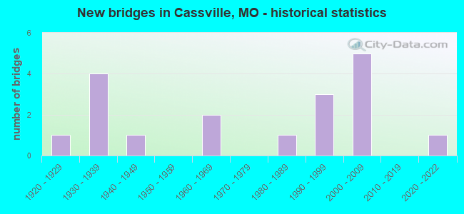
- New bridges - historical statistics
- 11920-1929
- 41930-1939
- 11940-1949
- 21960-1969
- 11980-1989
- 31990-1999
- 52000-2009
- 12020-2022

- Reconstructed bridges - Historical Statistics
- 11960-1969
- 11970-1979
- 11980-1989


- Bridge Condition - Deck
- 6.7%Excellent
- 33.3%Very good
- 33.3%Good
- 6.7%Satisfactory
- 20.0%Fair

- Bridge Condition - Superstructure
- 6.7%Excellent
- 20.0%Very good
- 40.0%Good
- 13.3%Satisfactory
- 20.0%Fair

- Bridge Condition - Substructure
- 6.7%Excellent
- 13.3%Very good
- 46.7%Good
- 13.3%Satisfactory
- 20.0%Fair

- Bridge Condition - Channel
- 5.6%Excellent
- 16.7%Very good
- 16.7%Good
- 50.0%Satisfactory
- 11.1%Fair

- Bridge Condition - Culverts
- 33.3%Good
- 33.3%Satisfactory
- 33.3%Fair
Find on map >> Show street view
Structure Number: 14689, Location: S 28 T 23 N R 27 W (Lat: 36.682506, Lng: -93.860681), Route carried "on" structure: City street , Year Built: 1988, Status: Open, Structure Length: 3.57m (11.71ft), Average Daily Traffic: 500 (year 2019), Truck Traffic: 10%, Average Future Daily Traffic: 850 (year 2039), Features Intersected: FLAT CR, Facility Carried by Structure: E 13TH ST
Minimum Vertical Clearance: 30+ m (98+ ft), Kilometerpoint: 0.161, Lanes on structure: 2, Owner: County Highway Agency, Maintenance Responsibility: City or Municipal Highway Agency, Approaching Roadway Width: 6.7m (22.0ft), Skew: 1 degrees, Material/Design: Prestressed concrete, Design/Construction: Tee Beam, Number Of Spans In Main Unit: 3, Length of Maximum Span: 11.9m (39.0ft), Curb-To-Curb Width: 8.5m (27.9ft), Out-to-Out Width: 10.8m (35.4ft)
Condition: Deck: Good, Superstructure: Satisfactory, Substructure: Good, Channel: Very good, Operating Rating: 49.5 metric tons, Method Used To Determine Operating Rating: Allowable Stress (AS), Inventory Rating: 32.4 metric tons, Method Used To Determine Inventory Rating: Allowable Stress (AS), Structural Evaluation: Equal to present minimum criteria, Deck Geometry: Somewhat better than minimum adequacy, Waterway Adequacy: Equal to present desirable criteria, Approach Roadway Alignment: Equal to present desirable criteria, Designated Inspection Frequency: Every 24 months, Inspection Date: Febuary 2022, Deck Structure Type: Concrete Cast-file-Place, Wearing Surface/Protective System: Wearing Surface: Monolithic Concrete
Find on map >> Show street view
Structure Number: 14694, Location: S 29 T 23 N R 27 W (Lat: 36.675644, Lng: -93.867514), Route carried "on" structure: City street , Year Built: 1923, Year Reconstructed: 1984, Status: Open, Structure Length: 1.37m (4.49ft), Average Daily Traffic: 1,500 (year 2019), Truck Traffic: 20%, Average Future Daily Traffic: 2,625 (year 2039), Features Intersected: FLAT CR, Facility Carried by Structure: SALE BARN RD
Minimum Vertical Clearance: 30+ m (98+ ft), Kilometerpoint: 0.322, Lanes on structure: 2, Owner: County Highway Agency, Maintenance Responsibility: City or Municipal Highway Agency, Approaching Roadway Width: 6.7m (22.0ft), Skew: 4 degrees, Material/Design: Concrete continuous, Design/Construction: Slab, Number Of Spans In Main Unit: 3, Length of Maximum Span: 4.0m (13.1ft), Curb-To-Curb Width: 8.5m (27.9ft), Out-to-Out Width: 9.1m (29.9ft)
Condition: Deck: Very good, Superstructure: Very good, Substructure: Very good, Channel: Satisfactory, Operating Rating: 35.1 metric tons, Method Used To Determine Operating Rating: Allowable Stress (AS), Inventory Rating: 18.9 metric tons, Method Used To Determine Inventory Rating: Allowable Stress (AS), Structural Evaluation: Somewhat better than minimum adequacy, Deck Geometry: Somewhat better than minimum adequacy, Waterway Adequacy: Somewhat better than minimum adequacy, Approach Roadway Alignment: Equal to present desirable criteria, Designated Inspection Frequency: Every 24 months, Inspection Date: Febuary 2022, Deck Structure Type: Concrete Cast-file-Place, Wearing Surface/Protective System: Wearing Surface: Monolithic Concrete
Find on map >> Show street view
Structure Number: 19611, Location: S 5 T 51 N R 9 W (Lat: 39.224167, Lng: -91.946667), Route carried "on" structure: County highway 227, Year Built: 1999, Status: Open, Structure Length: 2.07m (6.79ft), Average Daily Traffic: 100 (year 2021), Truck Traffic: 10%, Average Future Daily Traffic: 125 (year 2041), Design Load: HS 20, Features Intersected: SCULL LICK CR, Facility Carried by Structure: COUNTY RD 377
Minimum Vertical Clearance: 30+ m (98+ ft), Kilometerpoint: 1.448, Lanes on structure: 2, Owner: County Highway Agency, Approaching Roadway Width: 6.1m (20.0ft), Material/Design: Prestressed concrete, Design/Construction: Stringer/Multi-beam, Number Of Spans In Main Unit: 1, Length of Maximum Span: 20.1m (65.9ft), Curb-To-Curb Width: 7.3m (24.0ft), Out-to-Out Width: 8.0m (26.2ft)
Condition: Deck: Very good, Superstructure: Very good, Substructure: Good, Channel: Satisfactory, Operating Rating: 81.9 metric tons, Method Used To Determine Operating Rating: Load Factor (LF), Inventory Rating: 49.5 metric tons, Method Used To Determine Inventory Rating: Load Factor (LF), Structural Evaluation: Better than present minimum criteria, Deck Geometry: Equal to present minimum criteria, Waterway Adequacy: Equal to present minimum criteria, Approach Roadway Alignment: Equal to present desirable criteria, Designated Inspection Frequency: Every 24 months, Inspection Date: April 2021, Deck Structure Type: Concrete Precast Panels, Wearing Surface/Protective System: Wearing Surface: Monolithic Concrete
Find on map >> Show street view
Structure Number: 2435, Location: S 34 T 24 N R 27 W (Lat: 36.743422, Lng: -93.833178), Route carried "on" structure: County highway 481, Year Built: 1997, Status: Open, Structure Length: 1.68m (5.51ft), Average Daily Traffic: 25 (year 2019), Truck Traffic: 10%, Average Future Daily Traffic: 43 (year 2039), Features Intersected: FLAT CR, Facility Carried by Structure: COUNTY RD 2125
Minimum Vertical Clearance: 30+ m (98+ ft), Kilometerpoint: 3.058, Lanes on structure: 2, Owner: County Highway Agency, Approaching Roadway Width: 6.1m (20.0ft), Skew: 2 degrees, Material/Design: Concrete continuous, Design/Construction: Slab, Number Of Spans In Main Unit: 3, Length of Maximum Span: 4.9m (16.1ft), Curb-To-Curb Width: 6.7m (22.0ft), Out-to-Out Width: 7.0m (23.0ft)
Condition: Deck: Good, Superstructure: Good, Substructure: Good, Channel: Satisfactory, Operating Rating: 79.2 metric tons, Method Used To Determine Operating Rating: Load Factor (LF), Inventory Rating: 47.7 metric tons, Method Used To Determine Inventory Rating: Load Factor (LF), Structural Evaluation: Better than present minimum criteria, Deck Geometry: Somewhat better than minimum adequacy, Waterway Adequacy: Equal to present minimum criteria, Approach Roadway Alignment: Equal to present desirable criteria, Designated Inspection Frequency: Every 24 months, Inspection Date: Febuary 2022, Deck Structure Type: Concrete Cast-file-Place, Wearing Surface/Protective System: Wearing Surface: Monolithic Concrete
Find on map >> Show street view
Structure Number: 25033, Location: S 21 T 23 N R 27 W (Lat: 36.697183, Lng: -93.854111), Route carried "on" structure: County highway 603, Year Built: 1941, Status: Open, Structure Length: 3.66m (12.01ft), Average Daily Traffic: 150 (year 2019), Truck Traffic: 10%, Average Future Daily Traffic: 255 (year 2039), Design Load: H 15, Features Intersected: FLAT CR, Facility Carried by Structure: FARM RD 1120
Minimum Vertical Clearance: 30+ m (98+ ft), Kilometerpoint: 0.644, Lanes on structure: 2, Owner: County Highway Agency, Approaching Roadway Width: 5.5m (18.0ft), Material/Design: Concrete, Design/Construction: Tee Beam, Number Of Spans In Main Unit: 4, Length of Maximum Span: 9.1m (29.9ft), Curb-To-Curb Width: 6.1m (20.0ft), Out-to-Out Width: 6.7m (22.0ft)
Condition: Deck: Satisfactory, Superstructure: Satisfactory, Substructure: Fair, Channel: Satisfactory, Operating Rating: 42.3 metric tons, Method Used To Determine Operating Rating: Allowable Stress (AS), Inventory Rating: 21.6 metric tons, Method Used To Determine Inventory Rating: Allowable Stress (AS), Structural Evaluation: Somewhat better than minimum adequacy, Deck Geometry: Meets minimum limits, Waterway Adequacy: Better than present minimum criteria, Approach Roadway Alignment: Somewhat better than minimum adequacy, Designated Inspection Frequency: Every 24 months, Inspection Date: Febuary 2022, Deck Structure Type: Concrete Cast-file-Place, Wearing Surface/Protective System: Wearing Surface: Bituminous
Find on map >> Show street view
Structure Number: 25237, Location: S 10 T 23 N R 27 W (Lat: 36.713642, Lng: -93.844569), Route carried "on" structure: County highway 707, Year Built: 1998, Status: Open, Structure Length: 2.16m (7.09ft), Average Daily Traffic: 50 (year 2019), Truck Traffic: 10%, Average Future Daily Traffic: 85 (year 2039), Features Intersected: FLAT CR, Facility Carried by Structure: FARM RD 2150
Minimum Vertical Clearance: 30+ m (98+ ft), Kilometerpoint: 0.322, Lanes on structure: 2, Owner: County Highway Agency, Approaching Roadway Width: 5.5m (18.0ft), Skew: 2 degrees, Material/Design: Steel, Design/Construction: Stringer/Multi-beam, Number Of Spans In Main Unit: 1, Length of Maximum Span: 20.7m (67.9ft), Curb-To-Curb Width: 6.9m (22.6ft), Out-to-Out Width: 7.2m (23.6ft)
Condition: Deck: Very good, Superstructure: Good, Substructure: Good, Channel: Very good, Operating Rating: 55.8 metric tons, Method Used To Determine Operating Rating: Load Factor (LF), Inventory Rating: 33.3 metric tons, Method Used To Determine Inventory Rating: Load Factor (LF), Structural Evaluation: Better than present minimum criteria, Deck Geometry: Somewhat better than minimum adequacy, Waterway Adequacy: Meets minimum limits, Approach Roadway Alignment: Equal to present minimum criteria, Designated Inspection Frequency: Every 24 months, Inspection Date: Febuary 2022, Deck Structure Type: Concrete Cast-file-Place, Wearing Surface/Protective System: Wearing Surface: Monolithic Concrete
Find on map >> Show street view
Structure Number: 30316, Location: S 26 T 23 N R 27 W (Lat: 36.675119, Lng: -93.828978), Route carried "on" structure: County highway 1135, Year Built: 2002, Status: Open, Structure Length: 0.91m (2.99ft), Average Daily Traffic: 150 (year 2019), Truck Traffic: 10%, Average Future Daily Traffic: 255 (year 2039), Features Intersected: BR OF FLAT CR
Minimum Vertical Clearance: 30+ m (98+ ft), Kilometerpoint: 0.000, Lanes on structure: 2, Owner: County Highway Agency, Approaching Roadway Width: 6.1m (20.0ft), Material/Design: Steel, Design/Construction: Stringer/Multi-beam, Number Of Spans In Main Unit: 1, Length of Maximum Span: 8.8m (28.9ft), Curb-To-Curb Width: 6.1m (20.0ft), Out-to-Out Width: 6.2m (20.3ft)
Condition: Deck: Very good, Superstructure: Good, Substructure: Good, Channel: Good, Operating Rating: 99.0 metric tons, Method Used To Determine Operating Rating: Load Factor (LF), Inventory Rating: 59.4 metric tons, Method Used To Determine Inventory Rating: Load Factor (LF), Structural Evaluation: Better than present minimum criteria, Deck Geometry: Meets minimum limits, Waterway Adequacy: Equal to present minimum criteria, Approach Roadway Alignment: Equal to present desirable criteria, Designated Inspection Frequency: Every 24 months, Inspection Date: Febuary 2022, Deck Structure Type: Concrete Cast-file-Place, Wearing Surface/Protective System: Wearing Surface: Monolithic Concrete
Find on map >> Show street view
Structure Number: 30554, Location: S 32 T 23 N R 27 W (Lat: 36.667172, Lng: -93.880447), Route carried "on" structure: County highway 725, Year Built: 2005, Status: Open, Structure Length: 2.62m (8.60ft), Average Daily Traffic: 1,000 (year 2019), Truck Traffic: 10%, Average Future Daily Traffic: 1,700 (year 2039), Design Load: HS 20, Features Intersected: FLAT CR
Minimum Vertical Clearance: 30+ m (98+ ft), Kilometerpoint: 0.000, Lanes on structure: 2, Owner: County Highway Agency, Approaching Roadway Width: 10.4m (34.1ft), Material/Design: Prestressed concrete, Design/Construction: Stringer/Multi-beam, Number Of Spans In Main Unit: 1, Length of Maximum Span: 25.5m (83.7ft), Curb-To-Curb Width: 10.4m (34.1ft), Out-to-Out Width: 11.2m (36.7ft)
Condition: Deck: Good, Superstructure: Good, Substructure: Good, Channel: Very good, Operating Rating: 69.3 metric tons, Method Used To Determine Operating Rating: Load Factor (LF), Inventory Rating: 32.4 metric tons, Method Used To Determine Inventory Rating: Load Factor (LF), Structural Evaluation: Better than present minimum criteria, Deck Geometry: Equal to present minimum criteria, Waterway Adequacy: Equal to present minimum criteria, Approach Roadway Alignment: Equal to present desirable criteria, Designated Inspection Frequency: Every 24 months, Inspection Date: Febuary 2022, Deck Structure Type: Concrete Precast Panels, Wearing Surface/Protective System: Wearing Surface: Monolithic Concrete, Deck Protection: Epoxy Coated Reinforcing
Find on map >> Show street view
Structure Number: 31435, Location: S 32 T 23 N R 27 W (Lat: 36.670378, Lng: -93.876639), Route carried "on" structure: City street 7300, Year Built: 2004, Status: Open, Structure Length: 1.23m (4.04ft), Average Daily Traffic: 600 (year 2019), Truck Traffic: 10%, Average Future Daily Traffic: 1,020 (year 2039), Design Load: HS 20, Features Intersected: FLAT CR, Facility Carried by Structure: COURT DR
Minimum Vertical Clearance: 30+ m (98+ ft), Kilometerpoint: 0.000, Lanes on structure: 2, Owner: County Highway Agency, Maintenance Responsibility: City or Municipal Highway Agency, Approaching Roadway Width: 11.0m (36.1ft), Material/Design: Steel, Design/Construction: Stringer/Multi-beam, Number Of Spans In Main Unit: 1, Length of Maximum Span: 11.7m (38.4ft), Curb-To-Curb Width: 12.8m (42.0ft), Out-to-Out Width: 13.0m (42.7ft)
Condition: Deck: Good, Superstructure: Good, Substructure: Good, Channel: Satisfactory, Operating Rating: 76.5 metric tons, Method Used To Determine Operating Rating: Load Factor (LF), Inventory Rating: 45.9 metric tons, Method Used To Determine Inventory Rating: Load Factor (LF), Structural Evaluation: Better than present minimum criteria, Deck Geometry: Superior to present desirable criteria, Waterway Adequacy: Somewhat better than minimum adequacy, Approach Roadway Alignment: Equal to present desirable criteria, Designated Inspection Frequency: Every 24 months, Inspection Date: Febuary 2022, Deck Structure Type: Concrete Cast-file-Place, Wearing Surface/Protective System: Wearing Surface: Monolithic Concrete
Find on map >> Show street view
Structure Number: 32416, Location: S 21 T 23 N R 27 W (Lat: 36.692142, Lng: -93.858233), Route carried "on" structure: County highway 603, Year Built: 2008, Status: Open, Structure Length: 4.08m (13.39ft), Average Daily Traffic: 200 (year 2019), Truck Traffic: 10%, Average Future Daily Traffic: 340 (year 2039), Design Load: HS 20, Features Intersected: FLAT CR, Facility Carried by Structure: FARM RD 1120
Minimum Vertical Clearance: 30+ m (98+ ft), Kilometerpoint: 1.127, Lanes on structure: 2, Owner: County Highway Agency, Approaching Roadway Width: 7.3m (24.0ft), Skew: 3 degrees, Material/Design: Prestressed concrete continuous, Design/Construction: Stringer/Multi-beam, Number Of Spans In Main Unit: 2, Length of Maximum Span: 19.8m (65.0ft), Curb-To-Curb Width: 7.3m (24.0ft), Out-to-Out Width: 7.5m (24.6ft)
Condition: Deck: Very good, Superstructure: Very good, Substructure: Very good, Channel: Excellent, Operating Rating: 54.9 metric tons, Method Used To Determine Operating Rating: Load Factor (LF), Inventory Rating: 32.4 metric tons, Method Used To Determine Inventory Rating: Load Factor (LF), Structural Evaluation: Equal to present desirable criteria, Deck Geometry: Somewhat better than minimum adequacy, Waterway Adequacy: Equal to present minimum criteria, Approach Roadway Alignment: Equal to present minimum criteria, Designated Inspection Frequency: Every 24 months, Inspection Date: Febuary 2022, Deck Structure Type: Concrete Precast Panels, Wearing Surface/Protective System: Wearing Surface: Monolithic Concrete, Deck Protection: Epoxy Coated Reinforcing
Find on map >> Show street view
Structure Number: 32453, Location: S 29 T 23 N R 27 W (Lat: 36.681667, Lng: -93.879444), Route carried "on" structure: County highway 717, Year Built: 2007, Status: Open, Structure Length: 1.86m (6.10ft), Average Daily Traffic: 500 (year 2019), Truck Traffic: 10%, Average Future Daily Traffic: 850 (year 2039), Design Load: HS 20, Features Intersected: BR OF FLAT CR, Facility Carried by Structure: FARM ARD 2172
Minimum Vertical Clearance: 30+ m (98+ ft), Kilometerpoint: 2.414, Lanes on structure: 2, Owner: County Highway Agency, Approaching Roadway Width: 7.3m (24.0ft), Skew: 4 degrees, Material/Design: Steel, Design/Construction: Stringer/Multi-beam, Number Of Spans In Main Unit: 1, Length of Maximum Span: 17.7m (58.1ft), Curb-To-Curb Width: 7.3m (24.0ft), Out-to-Out Width: 7.5m (24.6ft)
Condition: Deck: Good, Superstructure: Good, Substructure: Satisfactory, Channel: Good, Inventory Rating: 86.4 metric tons, Method Used To Determine Inventory Rating: Load Factor (LF), Structural Evaluation: Equal to present minimum criteria, Deck Geometry: Meets minimum limits, Waterway Adequacy: Better than present minimum criteria, Approach Roadway Alignment: Equal to present desirable criteria, Designated Inspection Frequency: Every 24 months, Inspection Date: Febuary 2022, Deck Structure Type: Concrete Cast-file-Place, Wearing Surface/Protective System: Wearing Surface: Monolithic Concrete
Find on map >> Show street view
Structure Number: 36268, Location: S 3 T 23 N R 27 W (Lat: 36.737167, Lng: -93.839856), Route carried "on" structure: County highway 605, Year Built: 2020, Status: Open, Structure Length: 4.57m (14.99ft), Average Daily Traffic: 200 (year 2020), Truck Traffic: 10%, Average Future Daily Traffic: 340 (year 2040), Design Load: HS 20, Features Intersected: FLAT CR, Facility Carried by Structure: COUNTY ROAD 1135
Minimum Vertical Clearance: 30+ m (98+ ft), Kilometerpoint: 0.966, Lanes on structure: 2, Owner: County Highway Agency, Approaching Roadway Width: 7.3m (24.0ft), Skew: 3 degrees, Material/Design: Prestressed concrete continuous, Design/Construction: Box Beam or Girders - Multiple, Number Of Spans In Main Unit: 2, Length of Maximum Span: 22.9m (75.1ft), Curb-To-Curb Width: 7.3m (24.0ft), Out-to-Out Width: 7.3m (24.0ft)
Condition: Deck: Excellent, Superstructure: Excellent, Substructure: Excellent, Channel: Good, Operating Rating: 54.0 metric tons, Method Used To Determine Operating Rating: Load Factor (LF), Inventory Rating: 32.4 metric tons, Method Used To Determine Inventory Rating: Load Factor (LF), Structural Evaluation: Equal to present desirable criteria, Deck Geometry: Somewhat better than minimum adequacy, Waterway Adequacy: Better than present minimum criteria, Approach Roadway Alignment: Equal to present minimum criteria, Designated Inspection Frequency: Every 24 months, Inspection Date: Febuary 2022, Wearing Surface/Protective System: Wearing Surface: Monolithic Concrete
Find on map >> Show street view
Structure Number: 5369, Location: S 29 T 23 N R 27 W (Lat: 36.676264, Lng: -93.867003), Route carried "on" structure: State highway 76, Year Built: 1930, Year Reconstructed: 1971, Status: Open, Structure Length: 5.73m (18.80ft), Average Daily Traffic: 11,682 (year 2021), Truck Traffic: 6%, Average Future Daily Traffic: 22,780 (year 2041), Design Load: H 15, Features Intersected: FLAT CR
Minimum Vertical Clearance: 30+ m (98+ ft), Kilometerpoint: 85.554, Lanes on structure: 2, Base Highway Network: Yes, Owner: State Highway Agency, Approaching Roadway Width: 9.1m (29.9ft), Material/Design: Concrete, Design/Construction: Tee Beam, Number Of Spans In Main Unit: 5, Length of Maximum Span: 11.4m (37.4ft), Curb-To-Curb Width: 6.7m (22.0ft), Out-to-Out Width: 7.0m (23.0ft)
Condition: Deck: Fair, Superstructure: Fair, Substructure: Fair, Channel: Fair, Operating Rating: 45.9 metric tons, Method Used To Determine Operating Rating: Load Factor (LF), Inventory Rating: 27.0 metric tons, Method Used To Determine Inventory Rating: Load Factor (LF), Structural Evaluation: Somewhat better than minimum adequacy, Deck Geometry: High priority of replacement, Waterway Adequacy: Equal to present desirable criteria, Approach Roadway Alignment: Equal to present minimum criteria, Length Of Structure Improvement: 0.68m (2.23ft), Designated Inspection Frequency: Every 24 months, Inspection Date: September 2021, Bridge Improvement Cost: $856,000, Roadway Improvement Cost: $86,000, Total Project Cost: $1,284,000 ( Estimate for 2022), Deck Structure Type: Concrete Cast-file-Place, Wearing Surface/Protective System: Wearing Surface: Bituminous, Membrane: Built-up
Find on map >> Show street view
Structure Number: 537, Location: S 13 T 23 N R 27 W (Lat: 36.699108, Lng: -93.810003), Route carried "on" structure: State highway 248, Year Built: 1930, Status: Open, Structure Length: 2.41m (7.91ft), Average Daily Traffic: 5,075 (year 2021), Truck Traffic: 18%, Average Future Daily Traffic: 8,374 (year 2041), Design Load: H 15, Features Intersected: DRY BR
Minimum Vertical Clearance: 30+ m (98+ ft), Kilometerpoint: 6.288, Lanes on structure: 2, Owner: State Highway Agency, Approaching Roadway Width: 6.1m (20.0ft), Skew: 3 degrees, Material/Design: Concrete, Design/Construction: Slab, Number Of Spans In Main Unit: 3, Length of Maximum Span: 8.1m (26.6ft), Curb-To-Curb Width: 6.1m (20.0ft), Out-to-Out Width: 7.0m (23.0ft)
Condition: Deck: Fair, Superstructure: Fair, Substructure: Fair, Channel: Satisfactory, Operating Rating: 45.0 metric tons, Method Used To Determine Operating Rating: Load Factor (LF), Inventory Rating: 27.0 metric tons, Method Used To Determine Inventory Rating: Load Factor (LF), Structural Evaluation: Somewhat better than minimum adequacy, Deck Geometry: High priority of replacement, Waterway Adequacy: Equal to present desirable criteria, Approach Roadway Alignment: Equal to present minimum criteria, Length Of Structure Improvement: 0.33m (1.08ft), Designated Inspection Frequency: Every 24 months, Inspection Date: September 2021, Bridge Improvement Cost: $415,000, Roadway Improvement Cost: $41,000, Total Project Cost: $622,000 ( Estimate for 2022), Deck Structure Type: Concrete Cast-file-Place, Wearing Surface/Protective System: Wearing Surface: Bituminous
Find on map >> Show street view
Structure Number: 5433, Location: S 29 T 23 N R 27 W (Lat: 36.675528, Lng: -93.865567), Route carried "on" structure: State highway 248, Year Built: 1930, Year Reconstructed: 1989, Status: Open, Structure Length: 3.44m (11.29ft), Average Daily Traffic: 5,075 (year 2021), Truck Traffic: 18%, Average Future Daily Traffic: 8,374 (year 2041), Design Load: H 15, Features Intersected: FLAT CR BR
Minimum Vertical Clearance: 30+ m (98+ ft), Kilometerpoint: 0.027, Lanes on structure: 2, Owner: State Highway Agency, Approaching Roadway Width: 6.1m (20.0ft), Skew: 4 degrees, Material/Design: Concrete, Design/Construction: Tee Beam, Number Of Spans In Main Unit: 3, Length of Maximum Span: 11.4m (37.4ft), Curb-To-Curb Width: 6.7m (22.0ft), Out-to-Out Width: 7.0m (23.0ft)
Condition: Deck: Fair, Superstructure: Fair, Substructure: Satisfactory, Channel: Fair, Operating Rating: 45.9 metric tons, Method Used To Determine Operating Rating: Load Factor (LF), Inventory Rating: 27.9 metric tons, Method Used To Determine Inventory Rating: Load Factor (LF), Structural Evaluation: Somewhat better than minimum adequacy, Deck Geometry: High priority of replacement, Waterway Adequacy: Equal to present desirable criteria, Approach Roadway Alignment: Equal to present minimum criteria, Length Of Structure Improvement: 0.43m (1.41ft), Designated Inspection Frequency: Every 24 months, Inspection Date: September 2021, Bridge Improvement Cost: $541,000, Roadway Improvement Cost: $54,000, Total Project Cost: $812,000 ( Estimate for 2022), Deck Structure Type: Concrete Cast-file-Place, Wearing Surface/Protective System: Wearing Surface: Bituminous, Membrane: Built-up
Find on map >> Show street view
Structure Number: 5667, Location: S 18 T 23 N R 27 W (Lat: 36.707583, Lng: -93.894828), Route carried "on" structure: Business State highway 37, Year Built: 1932, Status: Open, Structure Length: 0.66m (2.17ft), Average Daily Traffic: 3,870 (year 2021), Truck Traffic: 8%, Average Future Daily Traffic: 6,386 (year 2041), Design Load: H 15, Features Intersected: HENRYS BR
Minimum Vertical Clearance: 30+ m (98+ ft), Kilometerpoint: 0.666, Lanes on structure: 2, Owner: State Highway Agency, Approaching Roadway Width: 10.4m (34.1ft), Skew: 1 degrees, Material/Design: Concrete continuous, Design/Construction: Culvert, Number Of Spans In Main Unit: 2, Length of Maximum Span: 3.0m (9.8ft)
Condition: Channel: Satisfactory, Culverts: Good, Operating Rating: 55.8 metric tons, Method Used To Determine Operating Rating: Load Factor (LF), Inventory Rating: 33.3 metric tons, Method Used To Determine Inventory Rating: Load Factor (LF), Structural Evaluation: Better than present minimum criteria, Waterway Adequacy: Equal to present desirable criteria, Approach Roadway Alignment: Equal to present desirable criteria, Designated Inspection Frequency: Every 24 months, Inspection Date: April 2020
Find on map >> Show street view
Structure Number: 9, Location: S 18 T 23 N R 27 W (Lat: 36.707206, Lng: -93.895539), Route carried "on" structure: State highway 37, Year Built: 1963, Status: Open, Structure Length: 0.82m (2.69ft), Average Daily Traffic: 7,985 (year 2021), Truck Traffic: 19%, Average Future Daily Traffic: 13,974 (year 2041), Design Load: H 20, Features Intersected: HENRYS BR
Minimum Vertical Clearance: 30+ m (98+ ft), Kilometerpoint: 98.416, Lanes on structure: 3, Base Highway Network: Yes, Owner: State Highway Agency, Approaching Roadway Width: 13.4m (44.0ft), Material/Design: Concrete continuous, Design/Construction: Culvert, Number Of Spans In Main Unit: 2, Length of Maximum Span: 4.0m (13.1ft)
Condition: Channel: Satisfactory, Culverts: Satisfactory, Operating Rating: 72.0 metric tons, Method Used To Determine Operating Rating: Field evaluation and documented engineering judgment, Inventory Rating: 43.2 metric tons, Method Used To Determine Inventory Rating: Field evaluation and documented engineering judgment, Structural Evaluation: Equal to present minimum criteria, Waterway Adequacy: Equal to present desirable criteria, Approach Roadway Alignment: Equal to present desirable criteria, Designated Inspection Frequency: Every 24 months, Inspection Date: April 2020
Find on map >> Show street view
Structure Number: 901, Location: S 30 T 23 N R 27 W (Lat: 36.681197, Lng: -93.885489), Route carried "on" structure: State highway 37, Year Built: 1963, Status: Open, Structure Length: 1.44m (4.72ft), Average Daily Traffic: 7,985 (year 2021), Truck Traffic: 19%, Average Future Daily Traffic: 13,974 (year 2041), Design Load: H 20, Features Intersected: TOWN BR
Minimum Vertical Clearance: 30+ m (98+ ft), Kilometerpoint: 101.485, Lanes on structure: 2, Base Highway Network: Yes, Owner: State Highway Agency, Approaching Roadway Width: 13.4m (44.0ft), Material/Design: Concrete continuous, Design/Construction: Culvert, Number Of Spans In Main Unit: 3, Length of Maximum Span: 4.6m (15.1ft)
Condition: Channel: Satisfactory, Culverts: Fair, Operating Rating: 72.0 metric tons, Method Used To Determine Operating Rating: Field evaluation and documented engineering judgment, Inventory Rating: 43.2 metric tons, Method Used To Determine Inventory Rating: Field evaluation and documented engineering judgment, Structural Evaluation: Somewhat better than minimum adequacy, Waterway Adequacy: Equal to present desirable criteria, Approach Roadway Alignment: Equal to present desirable criteria, Designated Inspection Frequency: Every 24 months, Inspection Date: April 2020