Bridge Statistics for Catheys Valley, California (CA)
Condition, Traffic, Stress, Structural Evaluation, Project Costs
- National Bridge Inventory (NBI) Statistics
- 15Number of bridges
- 89ft / 26.5mTotal length
- $401,000Total costs
- 33,890Total average daily traffic
- 1,654Total average daily truck traffic
- 35,820Total future (year 2038) average daily traffic
- National Bridge Inventory (NBI) Registered Bridges for Catheys Valley
- No street view available for this location
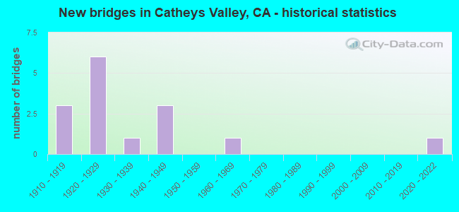
- New bridges - historical statistics
- 31910-1919
- 61920-1929
- 11930-1939
- 31940-1949
- 11960-1969
- 12020-2022

- Reconstructed bridges - Historical Statistics
- 21920-1929
- 01930-1939
- 01940-1949
- 01950-1959
- 01960-1969
- 21970-1979
- 11980-1989


- Bridge Condition - Deck
- 66.7%Good
- 26.7%Fair
- 6.7%Poor

- Bridge Condition - Superstructure
- 73.3%Good
- 26.7%Fair

- Bridge Condition - Substructure
- 33.3%Good
- 60.0%Fair
- 6.7%Poor

- Bridge Condition - Channel
- 86.7%Good
- 6.7%Satisfactory
- 6.7%Fair
Find on map >> Show street view
Structure Number: 40 0012, Location: 10-MPA-140-2.13 (Lat: 37.358244, Lng: -120.188408), Route carried "on" structure: State highway 140, Year Built: 1929, Year Reconstructed: 1980, Status: Open, Structure Length: 1.22m (4.00ft), Average Daily Traffic: 4,650 (year 2009), Truck Traffic: 5%, Average Future Daily Traffic: 4,625 (year 2042), Design Load: H 15, Features Intersected: MILES CREEK
Minimum Vertical Clearance: 30+ m (98+ ft), Kilometerpoint: 2.130, Lanes on structure: 4, Base Highway Network: Yes (Inventory Route: 1, Subroute: 1), Owner: State Highway Agency, Approaching Roadway Width: 18.3m (60.0ft), Skew: 2 degrees, Material/Design: Concrete, Design/Construction: Tee Beam, Number Of Spans In Main Unit: 2, Length of Maximum Span: 5.8m (19.0ft), Curb-To-Curb Width: 18.3m (60.0ft), Out-to-Out Width: 19.2m (63.0ft)
Condition: Deck: Good, Superstructure: Good, Substructure: Good, Channel: Satisfactory, Operating Rating: 25.3 metric tons, Method Used To Determine Operating Rating: Load and Resistance Factor Rating (LRFR) rating reported by rating factor(RF) method using HL-93 loadings, Inventory Rating: 19.4 metric tons, Method Used To Determine Inventory Rating: Load and Resistance Factor Rating (LRFR) rating reported by rating factor(RF) method using HL-93 loadings, Structural Evaluation: Somewhat better than minimum adequacy, Deck Geometry: Somewhat better than minimum adequacy, Waterway Adequacy: Equal to present desirable criteria, Approach Roadway Alignment: Equal to present desirable criteria, Designated Inspection Frequency: Every 24 months, Inspection Date: October 2020, Deck Structure Type: Concrete Cast-file-Place, Wearing Surface/Protective System: Wearing Surface: Bituminous
Find on map >> Show street view
Structure Number: 40 0013, Location: 10-MPA-140-2.89 (Lat: 37.363164, Lng: -120.177403), Route carried "on" structure: State highway 140, Year Built: 1928, Status: Open, Structure Length: 0.73m (2.40ft), Average Daily Traffic: 4,650 (year 2009), Truck Traffic: 5%, Average Future Daily Traffic: 4,595 (year 2040), Design Load: H 15, Features Intersected: MILES CREEK
Minimum Vertical Clearance: 30+ m (98+ ft), Kilometerpoint: 2.890, Lanes on structure: 2, Base Highway Network: Yes (Inventory Route: 1, Subroute: 1), Owner: State Highway Agency, Approaching Roadway Width: 8.8m (28.9ft), Material/Design: Concrete, Design/Construction: Tee Beam, Number Of Spans In Main Unit: 1, Length of Maximum Span: 6.1m (20.0ft), Curb-To-Curb Width: 10.4m (34.1ft), Out-to-Out Width: 11.3m (37.1ft)
Condition: Deck: Good, Superstructure: Good, Substructure: Fair, Channel: Good, Operating Rating: 50.9 metric tons, Method Used To Determine Operating Rating: Load Factor (LF), Inventory Rating: 30.5 metric tons, Method Used To Determine Inventory Rating: Load Factor (LF), Structural Evaluation: Somewhat better than minimum adequacy, Deck Geometry: Somewhat better than minimum adequacy, Waterway Adequacy: Equal to present desirable criteria, Approach Roadway Alignment: Equal to present desirable criteria, Designated Inspection Frequency: Every 24 months, Inspection Date: October 2020, Deck Structure Type: Concrete Cast-file-Place, Wearing Surface/Protective System: Wearing Surface: Bituminous
Find on map >> Show street view
Structure Number: 40 0014, Location: 10-MPA-140-3.46 (Lat: 37.370425, Lng: -120.172814), Route carried "on" structure: State highway 140, Year Built: 1916, Year Reconstructed: 1928, Status: Open, Structure Length: 0.73m (2.40ft), Average Daily Traffic: 4,650 (year 2009), Truck Traffic: 5%, Average Future Daily Traffic: 4,595 (year 2040), Design Load: HS 15, Features Intersected: MILES CREEK
Minimum Vertical Clearance: 30+ m (98+ ft), Kilometerpoint: 3.460, Lanes on structure: 2, Base Highway Network: Yes (Inventory Route: 1, Subroute: 1), Owner: State Highway Agency, Approaching Roadway Width: 9.1m (29.9ft), Material/Design: Concrete, Design/Construction: Tee Beam, Number Of Spans In Main Unit: 1, Length of Maximum Span: 6.7m (22.0ft), Curb-To-Curb Width: 10.2m (33.5ft), Out-to-Out Width: 11.6m (38.1ft)
Condition: Deck: Good, Superstructure: Good, Substructure: Fair, Channel: Good, Operating Rating: 47.3 metric tons, Method Used To Determine Operating Rating: Load Factor (LF), Inventory Rating: 28.5 metric tons, Method Used To Determine Inventory Rating: Load Factor (LF), Structural Evaluation: Somewhat better than minimum adequacy, Deck Geometry: Meets minimum limits, Waterway Adequacy: Equal to present desirable criteria, Approach Roadway Alignment: Equal to present desirable criteria, Designated Inspection Frequency: Every 24 months, Inspection Date: October 2020, Deck Structure Type: Concrete Cast-file-Place, Wearing Surface/Protective System: Wearing Surface: Bituminous
Find on map >> Show street view
Structure Number: 40 0015, Location: 10-MPA-140-3.50 (Lat: 37.371108, Lng: -120.171850), Route carried "on" structure: State highway 140, Year Built: 1928, Status: Open, Structure Length: 0.98m (3.22ft), Average Daily Traffic: 4,650 (year 2009), Truck Traffic: 5%, Average Future Daily Traffic: 4,626 (year 2042), Design Load: H 15, Features Intersected: MILES CREEK
Minimum Vertical Clearance: 30+ m (98+ ft), Kilometerpoint: 3.500, Lanes on structure: 2, Base Highway Network: Yes (Inventory Route: 1, Subroute: 1), Owner: State Highway Agency, Approaching Roadway Width: 9.1m (29.9ft), Skew: 4 degrees, Material/Design: Concrete, Design/Construction: Tee Beam, Number Of Spans In Main Unit: 1, Length of Maximum Span: 8.5m (27.9ft), Curb or Sidewalk Widths: Left: 0.3m (1.0ft), Right: 0.3m (1.0ft), Curb-To-Curb Width: 10.4m (34.1ft), Out-to-Out Width: 11.4m (37.4ft)
Condition: Deck: Good, Superstructure: Good, Substructure: Fair, Channel: Good, Operating Rating: 53.5 metric tons, Method Used To Determine Operating Rating: Load Factor (LF), Inventory Rating: 32.1 metric tons, Method Used To Determine Inventory Rating: Load Factor (LF), Structural Evaluation: Somewhat better than minimum adequacy, Deck Geometry: Somewhat better than minimum adequacy, Waterway Adequacy: Equal to present desirable criteria, Approach Roadway Alignment: Equal to present desirable criteria, Designated Inspection Frequency: Every 24 months, Inspection Date: October 2020, Deck Structure Type: Concrete Cast-file-Place, Wearing Surface/Protective System: Wearing Surface: Bituminous
Find on map >> Show street view
Structure Number: 40 0016, Location: 10-MPA-140-3.64 (Lat: 37.372150, Lng: -120.170389), Route carried "on" structure: State highway 140, Year Built: 1928, Status: Open, Structure Length: 0.73m (2.40ft), Average Daily Traffic: 4,650 (year 2009), Truck Traffic: 5%, Average Future Daily Traffic: 4,595 (year 2040), Design Load: HS 15, Features Intersected: MILES CREEK
Minimum Vertical Clearance: 30+ m (98+ ft), Kilometerpoint: 3.640, Lanes on structure: 2, Base Highway Network: Yes (Inventory Route: 1, Subroute: 1), Owner: State Highway Agency, Approaching Roadway Width: 9.8m (32.2ft), Skew: 1 degrees, Material/Design: Concrete, Design/Construction: Tee Beam, Number Of Spans In Main Unit: 1, Length of Maximum Span: 6.1m (20.0ft), Curb-To-Curb Width: 10.4m (34.1ft), Out-to-Out Width: 11.6m (38.1ft)
Condition: Deck: Good, Superstructure: Good, Substructure: Poor, Channel: Good, Operating Rating: 31.1 metric tons, Method Used To Determine Operating Rating: Load and Resistance Factor Rating (LRFR) rating reported by rating factor(RF) method using HL-93 loadings, Inventory Rating: 24.0 metric tons, Method Used To Determine Inventory Rating: Load and Resistance Factor Rating (LRFR) rating reported by rating factor(RF) method using HL-93 loadings, Structural Evaluation: Meets minimum limits, Deck Geometry: Somewhat better than minimum adequacy, Waterway Adequacy: Equal to present desirable criteria, Approach Roadway Alignment: Equal to present desirable criteria, Length Of Structure Improvement: 0.73m (2.40ft), Designated Inspection Frequency: Every 24 months, Inspection Date: October 2020, Bridge Improvement Cost: $190,000, Deck Structure Type: Concrete Cast-file-Place, Wearing Surface/Protective System: Wearing Surface: Bituminous
Find on map >> Show street view
Structure Number: 40 0017, Location: 10-MPA-140-3.81 (Lat: 37.374069, Lng: -120.168456), Route carried "on" structure: State highway 140, Year Built: 1928, Status: Open, Structure Length: 0.98m (3.22ft), Average Daily Traffic: 4,650 (year 2009), Truck Traffic: 5%, Average Future Daily Traffic: 4,595 (year 2040), Design Load: HS 15, Features Intersected: MILES CREEK
Minimum Vertical Clearance: 30+ m (98+ ft), Kilometerpoint: 3.810, Lanes on structure: 2, Base Highway Network: Yes (Inventory Route: 1, Subroute: 1), Owner: State Highway Agency, Approaching Roadway Width: 11.9m (39.0ft), Skew: 3 degrees, Material/Design: Concrete, Design/Construction: Tee Beam, Number Of Spans In Main Unit: 1, Length of Maximum Span: 8.5m (27.9ft), Curb or Sidewalk Widths: Left: 0.3m (1.0ft), Right: 0.3m (1.0ft), Curb-To-Curb Width: 10.4m (34.1ft), Out-to-Out Width: 11.3m (37.1ft)
Condition: Deck: Good, Superstructure: Good, Substructure: Fair, Channel: Good, Operating Rating: 31.8 metric tons, Method Used To Determine Operating Rating: Load and Resistance Factor Rating (LRFR) rating reported by rating factor(RF) method using HL-93 loadings, Inventory Rating: 24.6 metric tons, Method Used To Determine Inventory Rating: Load and Resistance Factor Rating (LRFR) rating reported by rating factor(RF) method using HL-93 loadings, Structural Evaluation: Somewhat better than minimum adequacy, Deck Geometry: Somewhat better than minimum adequacy, Waterway Adequacy: Equal to present desirable criteria, Approach Roadway Alignment: Equal to present desirable criteria, Designated Inspection Frequency: Every 24 months, Inspection Date: October 2020, Deck Structure Type: Concrete Cast-file-Place, Wearing Surface/Protective System: Wearing Surface: Bituminous
Find on map >> Show street view
Structure Number: 40 0018, Location: 10-MPA-140-4.06 (Lat: 37.377492, Lng: -120.167122), Route carried "on" structure: State highway 140, Year Built: 1916, Year Reconstructed: 1928, Status: Open, Structure Length: 0.85m (2.79ft), Average Daily Traffic: 4,650 (year 2009), Truck Traffic: 5%, Average Future Daily Traffic: 4,595 (year 2040), Design Load: HS 15, Features Intersected: MILES CREEK
Minimum Vertical Clearance: 30+ m (98+ ft), Kilometerpoint: 4.060, Lanes on structure: 2, Base Highway Network: Yes (Inventory Route: 1, Subroute: 1), Owner: State Highway Agency, Approaching Roadway Width: 8.8m (28.9ft), Skew: 3 degrees, Material/Design: Concrete, Design/Construction: Tee Beam, Number Of Spans In Main Unit: 1, Length of Maximum Span: 7.9m (25.9ft), Curb-To-Curb Width: 10.4m (34.1ft), Out-to-Out Width: 11.6m (38.1ft)
Condition: Deck: Good, Superstructure: Good, Substructure: Fair, Channel: Good, Operating Rating: 99.8 metric tons, Method Used To Determine Operating Rating: Load Factor (LF), Inventory Rating: 60.9 metric tons, Method Used To Determine Inventory Rating: Load Factor (LF), Structural Evaluation: Somewhat better than minimum adequacy, Deck Geometry: Somewhat better than minimum adequacy, Waterway Adequacy: Equal to present desirable criteria, Approach Roadway Alignment: Equal to present desirable criteria, Designated Inspection Frequency: Every 24 months, Inspection Date: October 2020, Deck Structure Type: Concrete Cast-file-Place, Wearing Surface/Protective System: Wearing Surface: Bituminous
Find on map >> Show street view
Structure Number: 40C0003, Location: 4.7 MI SW OF SR 49 (Lat: 37.433825, Lng: -120.003425), Route carried "on" structure: County highway , Year Built: 1919, Year Reconstructed: 1970, Status: Open, Structure Length: 5.38m (17.65ft), Average Daily Traffic: 180 (year 2005), Truck Traffic: 2%, Average Future Daily Traffic: 695 (year 2038), Features Intersected: AGUA FRIA CREEK, Facility Carried by Structure: OLD HIGHWAY ROAD
Minimum Vertical Clearance: 30+ m (98+ ft), Kilometerpoint: 0.000, Lanes on structure: 2, Owner: County Highway Agency, Approaching Roadway Width: 5.5m (18.0ft), Material/Design: Concrete continuous, Design/Construction: Slab, Number Of Spans In Main Unit: 2, Number Of Approach Spans: 6, Length of Maximum Span: 6.7m (22.0ft), Curb-To-Curb Width: 6.4m (21.0ft), Out-to-Out Width: 7.2m (23.6ft)
Condition: Deck: Fair, Superstructure: Fair, Substructure: Fair, Channel: Fair, Operating Rating: 26.9 metric tons, Method Used To Determine Operating Rating: Field evaluation and documented engineering judgment, Inventory Rating: 16.2 metric tons, Method Used To Determine Inventory Rating: Field evaluation and documented engineering judgment, Structural Evaluation: Somewhat better than minimum adequacy, Deck Geometry: Meets minimum limits, Waterway Adequacy: Superior to present desirable criteria, Approach Roadway Alignment: Equal to present minimum criteria, Designated Inspection Frequency: Every 24 months, Inspection Date: September 2021, Deck Structure Type: Concrete Cast-file-Place
Find on map >> Show street view
Structure Number: 40C0008, Location: 3.6 MI N OF SR 140 (Lat: 37.477919, Lng: -120.113506), Route carried "on" structure: County highway , Year Built: 1948, Status: Open, Structure Length: 1.62m (5.31ft), Average Daily Traffic: 350 (year 2004), Truck Traffic: 2%, Average Future Daily Traffic: 739 (year 2040), Features Intersected: BEAR CREEK, Facility Carried by Structure: HORNITOS ROAD
Minimum Vertical Clearance: 30+ m (98+ ft), Kilometerpoint: 0.000, Lanes on structure: 2, Owner: County Highway Agency, Approaching Roadway Width: 7.3m (24.0ft), Skew: 3 degrees, Material/Design: Concrete continuous, Design/Construction: Slab, Number Of Spans In Main Unit: 2, Length of Maximum Span: 7.9m (25.9ft), Curb or Sidewalk Widths: Left: 0.6m (2.0ft), Right: 0.6m (2.0ft), Curb-To-Curb Width: 6.7m (22.0ft), Out-to-Out Width: 8.1m (26.6ft)
Condition: Deck: Good, Superstructure: Good, Substructure: Good, Channel: Good, Operating Rating: 27.9 metric tons, Method Used To Determine Operating Rating: Field evaluation and documented engineering judgment, Inventory Rating: 16.8 metric tons, Method Used To Determine Inventory Rating: Field evaluation and documented engineering judgment, Structural Evaluation: Somewhat better than minimum adequacy, Deck Geometry: Meets minimum limits, Waterway Adequacy: Equal to present desirable criteria, Approach Roadway Alignment: Equal to present minimum criteria, Designated Inspection Frequency: Every 24 months, Inspection Date: June 2020, Deck Structure Type: Concrete Cast-file-Place, Wearing Surface/Protective System: Wearing Surface: Bituminous
Find on map >> Show street view
Structure Number: 40C001, Location: 0.1 MI W OLD TOLL RD (Lat: 37.491506, Lng: -120.142847), Route carried "on" structure: County highway , Year Built: 1947, Status: Open, Structure Length: 1.62m (5.31ft), Average Daily Traffic: 150 (year 2004), Truck Traffic: 3%, Average Future Daily Traffic: 526 (year 2040), Design Load: H 15, Features Intersected: CORBET CREEK, Facility Carried by Structure: HORNITOS ROAD
Minimum Vertical Clearance: 30+ m (98+ ft), Kilometerpoint: 0.000, Lanes on structure: 2, Owner: County Highway Agency, Approaching Roadway Width: 6.4m (21.0ft), Material/Design: Concrete continuous, Design/Construction: Slab, Number Of Spans In Main Unit: 2, Length of Maximum Span: 7.9m (25.9ft), Curb or Sidewalk Widths: Left: 0.6m (2.0ft), Right: 0.6m (2.0ft), Curb-To-Curb Width: 6.7m (22.0ft), Out-to-Out Width: 8.1m (26.6ft)
Condition: Deck: Good, Superstructure: Good, Substructure: Good, Channel: Good, Operating Rating: 38.9 metric tons, Method Used To Determine Operating Rating: Load Factor (LF), Inventory Rating: 23.3 metric tons, Method Used To Determine Inventory Rating: Load Factor (LF), Structural Evaluation: Equal to present minimum criteria, Deck Geometry: Meets minimum limits, Waterway Adequacy: Equal to present desirable criteria, Approach Roadway Alignment: Equal to present desirable criteria, Designated Inspection Frequency: Every 24 months, Inspection Date: June 2020, Deck Structure Type: Concrete Cast-file-Place, Wearing Surface/Protective System: Wearing Surface: Bituminous
Find on map >> Show street view
Structure Number: 40C0032, Location: 1.6 MI S/O OLD HWY (Lat: 37.398942, Lng: -120.003694), Route carried "on" structure: County highway , Year Built: 1968, Status: Open, Structure Length: 2.20m (7.22ft), Average Daily Traffic: 20 (year 2005), Average Future Daily Traffic: 51 (year 2038), Features Intersected: MARIPOSA CREEK, Facility Carried by Structure: WHITE ROCK ROAD
Minimum Vertical Clearance: 30+ m (98+ ft), Kilometerpoint: 0.000, Lanes on structure: 1, Owner: County Highway Agency, Approaching Roadway Width: 5.2m (17.1ft), Material/Design: Steel, Design/Construction: Girder and Floorbeam System, Number Of Spans In Main Unit: 1, Number Of Approach Spans: 1, Length of Maximum Span: 15.2m (49.9ft), Curb or Sidewalk Widths: Left: 0.3m (1.0ft), Right: 0.3m (1.0ft), Curb-To-Curb Width: 4.3m (14.1ft), Out-to-Out Width: 4.9m (16.1ft)
Condition: Deck: Fair, Superstructure: Fair, Substructure: Fair, Channel: Good, Operating Rating: 27.2 metric tons, Method Used To Determine Operating Rating: Load Factor (LF), Inventory Rating: 16.2 metric tons, Method Used To Determine Inventory Rating: Load Factor (LF), Structural Evaluation: Somewhat better than minimum adequacy, Deck Geometry: Equal to present minimum criteria, Waterway Adequacy: Equal to present desirable criteria, Approach Roadway Alignment: High priority of corrective action, Designated Inspection Frequency: Every 24 months, Critical Feature Inspection Frequency: Every 24 months, Inspection Date: September 2021, Critical Feature Inspection Date: June 2020, Deck Structure Type: Concrete Cast-file-Place
Find on map >> Show street view
Structure Number: 40C0053, Location: 0.9 MI SE OF SR 140 (Lat: 37.415933, Lng: -120.100869), Route carried "on" structure: County highway , Year Built: 1936, Year Reconstructed: 1970, Status: Open, Structure Length: 0.82m (2.69ft), Average Daily Traffic: 380 (year 2004), Truck Traffic: 3%, Average Future Daily Traffic: 843 (year 2040), Features Intersected: OWENS CREEK, Facility Carried by Structure: SCHOOL HOUSE ROAD
Minimum Vertical Clearance: 30+ m (98+ ft), Kilometerpoint: 0.000, Lanes on structure: 2, Owner: County Highway Agency, Approaching Roadway Width: 6.3m (20.7ft), Material/Design: Concrete, Design/Construction: Slab, Number Of Spans In Main Unit: 1, Length of Maximum Span: 6.4m (21.0ft), Curb-To-Curb Width: 6.3m (20.7ft), Out-to-Out Width: 6.7m (22.0ft)
Condition: Deck: Fair, Superstructure: Fair, Substructure: Fair, Channel: Good, Operating Rating: 28.2 metric tons, Method Used To Determine Operating Rating: Field evaluation and documented engineering judgment, Inventory Rating: 16.8 metric tons, Method Used To Determine Inventory Rating: Field evaluation and documented engineering judgment, Structural Evaluation: Somewhat better than minimum adequacy, Deck Geometry: Meets minimum limits, Waterway Adequacy: Equal to present desirable criteria, Approach Roadway Alignment: Equal to present minimum criteria, Designated Inspection Frequency: Every 24 months, Inspection Date: June 2020, Deck Structure Type: Concrete Cast-file-Place, Wearing Surface/Protective System: Wearing Surface: Bituminous
Find on map >> Show street view
Structure Number: 40C0057, Location: 3.0 MI W OF SR 49 (Lat: 37.508694, Lng: -120.094903), Route carried "on" structure: County highway , Year Built: 1948, Status: Open, Structure Length: 2.23m (7.32ft), Average Daily Traffic: 130 (year 2004), Truck Traffic: 2%, Average Future Daily Traffic: 316 (year 2040), Design Load: H 10, Features Intersected: BEAR CREEK, Facility Carried by Structure: OLD TOLL ROAD
Minimum Vertical Clearance: 30+ m (98+ ft), Kilometerpoint: 0.000, Lanes on structure: 1, Owner: County Highway Agency, Approaching Roadway Width: 6.1m (20.0ft), Material/Design: Wood or Timber, Design/Construction: Stringer/Multi-beam, Number Of Spans In Main Unit: 3, Length of Maximum Span: 7.3m (24.0ft), Curb or Sidewalk Widths: Left: 0.1m (0.3ft), Right: 0.1m (0.3ft), Curb-To-Curb Width: 4.2m (13.8ft), Out-to-Out Width: 4.7m (15.4ft)
Condition: Deck: Poor, Superstructure: Good, Substructure: Good, Channel: Good, Operating Rating: 28.8 metric tons, Method Used To Determine Operating Rating: Allowable Stress (AS), Inventory Rating: 17.8 metric tons, Method Used To Determine Inventory Rating: Allowable Stress (AS), Structural Evaluation: Somewhat better than minimum adequacy, Deck Geometry: High priority of replacement, Waterway Adequacy: Equal to present desirable criteria, Approach Roadway Alignment: Somewhat better than minimum adequacy, Length Of Structure Improvement: 2.23m (7.32ft), Designated Inspection Frequency: Every 24 months, Inspection Date: June 2020, Bridge Improvement Cost: $104,000, Roadway Improvement Cost: $47,000, Total Project Cost: $401,000 ( Estimate for 2017), Deck Structure Type: Concrete Cast-file-Place, Wearing Surface/Protective System: Wearing Surface: Bituminous
Find on map >> Show street view
Structure Number: 40C0058, Location: 0.3 MI EAST OF SR 140 (Lat: 37.406614, Lng: -120.123369), Route carried "on" structure: County highway , Year Built: 1920, Status: Open, Structure Length: 1.52m (4.99ft), Average Daily Traffic: 100 (year 2004), Truck Traffic: 3%, Average Future Daily Traffic: 316 (year 2040), Features Intersected: OWENS CREEK, Facility Carried by Structure: OLD HIGHWAY
Minimum Vertical Clearance: 30+ m (98+ ft), Kilometerpoint: 0.000, Lanes on structure: 2, Owner: County Highway Agency, Approaching Roadway Width: 5.5m (18.0ft), Skew: 3 degrees, Material/Design: Concrete continuous, Design/Construction: Tee Beam, Number Of Spans In Main Unit: 2, Length of Maximum Span: 7.6m (24.9ft), Curb or Sidewalk Widths: Left: 0.2m (0.7ft), Right: 0.2m (0.7ft), Curb-To-Curb Width: 5.6m (18.4ft), Out-to-Out Width: 6.2m (20.3ft)
Condition: Deck: Fair, Superstructure: Fair, Substructure: Fair, Channel: Good, Operating Rating: 28.2 metric tons, Method Used To Determine Operating Rating: Field evaluation and documented engineering judgment, Inventory Rating: 16.8 metric tons, Method Used To Determine Inventory Rating: Field evaluation and documented engineering judgment, Structural Evaluation: Somewhat better than minimum adequacy, Deck Geometry: Meets minimum limits, Waterway Adequacy: Equal to present desirable criteria, Approach Roadway Alignment: Somewhat better than minimum adequacy, Designated Inspection Frequency: Every 24 months, Inspection Date: June 2020, Deck Structure Type: Concrete Cast-file-Place, Wearing Surface/Protective System: Wearing Surface: Bituminous
Find on map >> Show street view
Structure Number: 40C0071, Location: 3.0 MI NW OF SR 140 (Lat: 37.427622, Lng: -120.168528), Route carried "on" structure: County highway , Year Built: 2021, Status: Open, Structure Length: 4.91m (16.11ft), Average Daily Traffic: 30 (year 2004), Truck Traffic: 2%, Average Future Daily Traffic: 108 (year 2043), Design Load: HL 93, Features Intersected: BEAR CREEK, Facility Carried by Structure: INDIAN GULCH ROAD
Minimum Vertical Clearance: 30+ m (98+ ft), Kilometerpoint: 0.000, Lanes on structure: 1, Owner: County Highway Agency, Approaching Roadway Width: 3.7m (12.1ft), Material/Design: Steel, Design/Construction: Truss - Thru, Number Of Spans In Main Unit: 1, Length of Maximum Span: 48.6m (159.4ft), Curb-To-Curb Width: 3.7m (12.1ft), Out-to-Out Width: 3.7m (12.1ft)
Condition: Deck: Good, Superstructure: Good, Substructure: Good, Channel: Good, Operating Rating: 54.1 metric tons, Method Used To Determine Operating Rating: Field evaluation and documented engineering judgment, Inventory Rating: 32.4 metric tons, Method Used To Determine Inventory Rating: Field evaluation and documented engineering judgment, Structural Evaluation: Better than present minimum criteria, Deck Geometry: Meets minimum limits, Waterway Adequacy: Equal to present desirable criteria, Approach Roadway Alignment: Equal to present desirable criteria, Designated Inspection Frequency: Every 24 months, Critical Feature Inspection Frequency: Every 24 months, Other Special Inspection Frequency: Every 48 months, Inspection Date: September 2021, Critical Feature Inspection Date: May 2021, Other Special Inspection Date: May 2021, Deck Structure Type: Steel plate, Wearing Surface/Protective System: Wearing Surface: Epoxy Overlay