Bridge Statistics for Central City, Kentucky (KY)
Condition, Traffic, Stress, Structural Evaluation, Project Costs
- National Bridge Inventory (NBI) Statistics
- 49Number of bridges
- 436ft / 133mTotal length
- $6,701,000Total costs
- 207,012Total average daily traffic
- 36,939Total average daily truck traffic
- National Bridge Inventory (NBI) Registered Bridges for Central City
- No street view available for this location
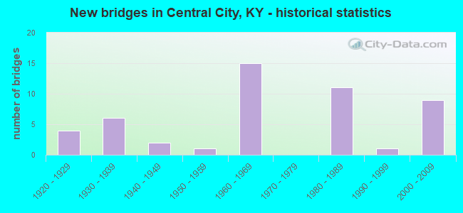
- New bridges - historical statistics
- 41920-1929
- 61930-1939
- 21940-1949
- 11950-1959
- 151960-1969
- 111980-1989
- 11990-1999
- 92000-2009


- Bridge Condition - Deck
- 8.0%Good
- 64.0%Satisfactory
- 28.0%Fair

- Bridge Condition - Superstructure
- 8.0%Good
- 36.0%Satisfactory
- 56.0%Fair

- Bridge Condition - Substructure
- 4.0%Good
- 28.0%Satisfactory
- 68.0%Fair

- Bridge Condition - Channel
- 5.9%Very good
- 70.6%Good
- 17.6%Satisfactory
- 5.9%Fair

- Bridge Condition - Culverts
- 14.3%Good
- 71.4%Satisfactory
- 14.3%Fair
Find on map >> Show street view
Structure Number: 89B00047N, Location: 1.0 MI WEST OF JCT US 431 (Lat: 37.295278, Lng: -87.141111), Route carried "on" structure: State highway 70, Year Built: 1934, Status: Open, Structure Length: 5.06m (16.60ft), Average Daily Traffic: 3,381 (year 2019), Truck Traffic: 9%, Average Future Daily Traffic: 3,144 (year 2039), Design Load: H 15, Features Intersected: LITTLE CYPRESS CREEK
Minimum Vertical Clearance: 30+ m (98+ ft), Kilometerpoint: 23.125, Lanes on structure: 2, Owner: State Highway Agency, Approaching Roadway Width: 6.4m (21.0ft), Material/Design: Concrete, Design/Construction: Tee Beam, Number Of Spans In Main Unit: 5, Length of Maximum Span: 9.1m (29.9ft), Curb or Sidewalk Widths: Left: 0.2m (0.7ft), Right: 0.2m (0.7ft), Curb-To-Curb Width: 7.3m (24.0ft), Out-to-Out Width: 8.3m (27.2ft)
Condition: Deck: Satisfactory, Superstructure: Satisfactory, Substructure: Fair, Channel: Good, Operating Rating: 65.4 metric tons, Method Used To Determine Operating Rating: Load Factor (LF), Inventory Rating: 39.3 metric tons, Method Used To Determine Inventory Rating: Load Factor (LF), Structural Evaluation: Somewhat better than minimum adequacy, Deck Geometry: High priority of replacement, Waterway Adequacy: Better than present minimum criteria, Approach Roadway Alignment: Equal to present desirable criteria, Length Of Structure Improvement: 0.51m (1.67ft), Designated Inspection Frequency: Every 24 months, Inspection Date: September 2021, Bridge Improvement Cost: $529,000, Total Project Cost: $529,000, Deck Structure Type: Concrete Cast-file-Place, Wearing Surface/Protective System: Wearing Surface: Latex Concrete
Find on map >> Show street view
Structure Number: 89B00048N, Location: .75 MI EAST OF JCT KY 181 (Lat: 37.303056, Lng: -87.197222), Route carried "on" structure: State highway 70, Year Built: 1934, Status: Open, Structure Length: 7.07m (23.20ft), Average Daily Traffic: 2,098 (year 2018), Truck Traffic: 9%, Average Future Daily Traffic: 1,846 (year 2038), Design Load: H 15, Features Intersected: CYPRESS CREEK
Minimum Vertical Clearance: 30+ m (98+ ft), Kilometerpoint: 17.803, Lanes on structure: 2, Owner: State Highway Agency, Approaching Roadway Width: 6.4m (21.0ft), Material/Design: Concrete, Design/Construction: Tee Beam, Number Of Spans In Main Unit: 7, Length of Maximum Span: 9.1m (29.9ft), Curb or Sidewalk Widths: Left: 0.2m (0.7ft), Right: 0.2m (0.7ft), Curb-To-Curb Width: 7.3m (24.0ft), Out-to-Out Width: 8.2m (26.9ft)
Condition: Deck: Satisfactory, Superstructure: Fair, Substructure: Fair, Channel: Good, Operating Rating: 65.4 metric tons, Method Used To Determine Operating Rating: Load Factor (LF), Inventory Rating: 39.3 metric tons, Method Used To Determine Inventory Rating: Load Factor (LF), Structural Evaluation: Somewhat better than minimum adequacy, Deck Geometry: High priority of replacement, Waterway Adequacy: Better than present minimum criteria, Approach Roadway Alignment: Equal to present desirable criteria, Length Of Structure Improvement: 0.71m (2.33ft), Designated Inspection Frequency: Every 24 months, Inspection Date: September 2021, Bridge Improvement Cost: $740,000, Total Project Cost: $739,000, Deck Structure Type: Concrete Cast-file-Place, Wearing Surface/Protective System: Wearing Surface: Latex Concrete
Find on map >> Show street view
Structure Number: 89B00058N, Location: .1 MI S OF JCT US 62 (Lat: 37.313611, Lng: -87.054167), Route carried "on" structure: State highway 2695, Year Built: 1963, Status: Posted for load, Structure Length: 5.55m (18.21ft), Average Daily Traffic: 33 (year 2020), Average Future Daily Traffic: 28 (year 2040), Design Load: H 15, Features Intersected: WESTERN KY PKWY @ 61.86
Minimum Vertical Clearance: 30+ m (98+ ft), Kilometerpoint: 0.237, Lanes on structure: 2, Lanes under structure: 4, Owner: State Highway Agency, Approaching Roadway Width: 5.5m (18.0ft), Skew: 1 degrees, Material/Design: Concrete, Design/Construction: Tee Beam, Number Of Spans In Main Unit: 4, Length of Maximum Span: 15.2m (49.9ft), Curb or Sidewalk Widths: Left: 0.5m (1.6ft), Right: 0.5m (1.6ft), Curb-To-Curb Width: 6.7m (22.0ft), Out-to-Out Width: 8.3m (27.2ft)
Condition: Deck: Satisfactory, Superstructure: Fair, Substructure: Satisfactory, Operating Rating: 43.4 metric tons, Method Used To Determine Operating Rating: Load Factor (LF), Inventory Rating: 26.0 metric tons, Method Used To Determine Inventory Rating: Load Factor (LF), Structural Evaluation: Somewhat better than minimum adequacy, Deck Geometry: Somewhat better than minimum adequacy, Underclear: Somewhat better than minimum adequacy, Approach Roadway Alignment: Somewhat better than minimum adequacy, Bridge Posting: Required (Relationship of Operating Rating to Maximum Legal Load: 30.0 - 39.9% below), Designated Inspection Frequency: Every 24 months, Inspection Date: September 2021, Deck Structure Type: Concrete Cast-file-Place, Wearing Surface/Protective System: Wearing Surface: Monolithic Concrete
Find on map >> Show street view
Structure Number: 89B00068N, Location: .60 MI SOU. OF JCT KY 70 (Lat: 37.291667, Lng: -87.210833), Route carried "on" structure: State highway 181, Year Built: 1932, Status: Open, Structure Length: 2.01m (6.59ft), Average Daily Traffic: 2,850 (year 2016), Average Future Daily Traffic: 2,508 (year 2036), Design Load: H 15, Features Intersected: CYPRESS CREEK
Minimum Vertical Clearance: 30+ m (98+ ft), Kilometerpoint: 29.391, Lanes on structure: 2, Owner: State Highway Agency, Approaching Roadway Width: 5.5m (18.0ft), Material/Design: Concrete, Design/Construction: Tee Beam, Number Of Spans In Main Unit: 2, Length of Maximum Span: 9.1m (29.9ft), Curb or Sidewalk Widths: Left: 0.2m (0.7ft), Right: 0.2m (0.7ft), Curb-To-Curb Width: 5.9m (19.4ft), Out-to-Out Width: 7.1m (23.3ft)
Condition: Deck: Satisfactory, Superstructure: Good, Substructure: Fair, Channel: Fair, Operating Rating: 72.0 metric tons, Method Used To Determine Operating Rating: Load Factor (LF), Inventory Rating: 43.3 metric tons, Method Used To Determine Inventory Rating: Load Factor (LF), Structural Evaluation: Somewhat better than minimum adequacy, Deck Geometry: High priority of replacement, Waterway Adequacy: Better than present minimum criteria, Approach Roadway Alignment: Equal to present desirable criteria, Length Of Structure Improvement: 0.20m (0.66ft), Designated Inspection Frequency: Every 24 months, Inspection Date: October 2021, Bridge Improvement Cost: $177,000, Total Project Cost: $177,000, Deck Structure Type: Concrete Cast-file-Place, Wearing Surface/Protective System: Wearing Surface: Latex Concrete
Find on map >> Show street view
Structure Number: 89B00069N, Location: .20 MI NOR. OF JCT KY 70 (Lat: 37.305833, Lng: -87.213889), Route carried "on" structure: State highway 181, Year Built: 1932, Status: Open, Structure Length: 1.01m (3.31ft), Average Daily Traffic: 1,986 (year 2018), Average Future Daily Traffic: 1,747 (year 2038), Design Load: H 15, Features Intersected: BRANCH OF CYPRESS CREEK
Minimum Vertical Clearance: 30+ m (98+ ft), Kilometerpoint: 31.006, Lanes on structure: 2, Owner: State Highway Agency, Approaching Roadway Width: 5.5m (18.0ft), Material/Design: Concrete, Design/Construction: Tee Beam, Number Of Spans In Main Unit: 1, Length of Maximum Span: 9.1m (29.9ft), Curb or Sidewalk Widths: Left: 0.2m (0.7ft), Right: 0.2m (0.7ft), Curb-To-Curb Width: 6.0m (19.7ft), Out-to-Out Width: 7.1m (23.3ft)
Condition: Deck: Fair, Superstructure: Satisfactory, Substructure: Fair, Channel: Satisfactory, Operating Rating: 68.0 metric tons, Method Used To Determine Operating Rating: Load Factor (LF), Inventory Rating: 40.8 metric tons, Method Used To Determine Inventory Rating: Load Factor (LF), Structural Evaluation: Somewhat better than minimum adequacy, Deck Geometry: High priority of replacement, Waterway Adequacy: Better than present minimum criteria, Approach Roadway Alignment: Equal to present desirable criteria, Length Of Structure Improvement: 0.10m (0.33ft), Designated Inspection Frequency: Every 24 months, Inspection Date: September 2021, Bridge Improvement Cost: $89,000, Total Project Cost: $88,000, Deck Structure Type: Concrete Cast-file-Place, Wearing Surface/Protective System: Wearing Surface: Latex Concrete
Find on map >> Show street view
Structure Number: 89B00071N, Location: .85 MI EAST OF JCT KY 277 (Lat: 37.326944, Lng: -87.094444), Route carried "on" structure: State highway 1379, Year Built: 1952, Status: Posted for load, Structure Length: 2.56m (8.40ft), Average Daily Traffic: 363 (year 2016), Average Future Daily Traffic: 315 (year 2036), Design Load: H 15, Features Intersected: NELSON CREEK
Minimum Vertical Clearance: 30+ m (98+ ft), Kilometerpoint: 1.572, Lanes on structure: 2, Owner: State Highway Agency, Approaching Roadway Width: 5.5m (18.0ft), Material/Design: Concrete, Design/Construction: Tee Beam, Number Of Spans In Main Unit: 3, Length of Maximum Span: 7.6m (24.9ft), Curb or Sidewalk Widths: Left: 0.3m (1.0ft), Right: 0.3m (1.0ft), Curb-To-Curb Width: 6.1m (20.0ft), Out-to-Out Width: 7.3m (24.0ft)
Condition: Deck: Satisfactory, Superstructure: Satisfactory, Substructure: Satisfactory, Channel: Good, Operating Rating: 44.9 metric tons, Method Used To Determine Operating Rating: Load Factor (LF), Inventory Rating: 26.9 metric tons, Method Used To Determine Inventory Rating: Load Factor (LF), Structural Evaluation: Equal to present minimum criteria, Deck Geometry: Meets minimum limits, Waterway Adequacy: Equal to present minimum criteria, Approach Roadway Alignment: Better than present minimum criteria, Bridge Posting: Required (Relationship of Operating Rating to Maximum Legal Load: > 39.9% below), Designated Inspection Frequency: Every 24 months, Inspection Date: September 2021, Deck Structure Type: Concrete Cast-file-Place, Wearing Surface/Protective System: Wearing Surface: Low Slump Concrete
Find on map >> Show street view
Structure Number: 89B00092L, Location: WBL 1.0 MI E OF US 431 NT (Lat: 37.287222, Lng: -87.088056), Route carried "on" structure: State highway 9001, Year Built: 1963, Status: Open, Structure Length: 3.66m (12.01ft), Average Daily Traffic: 4,545 (year 2019), Truck Traffic: 35%, Average Future Daily Traffic: 4,272 (year 2039), Design Load: HS 20, Features Intersected: CLEATON-GREEN RIVER RD, Facility Carried by Structure: WENDELL H FORD WES
Minimum Vertical Clearance: 30+ m (98+ ft), Kilometerpoint: 95.286, Lanes on structure: 2, Lanes under structure: 2, Base Highway Network: Yes, Owner: State Highway Agency, Approaching Roadway Width: 11.6m (38.1ft), Skew: 2 degrees, Material/Design: Concrete, Design/Construction: Tee Beam, Number Of Spans In Main Unit: 3, Length of Maximum Span: 11.3m (37.1ft), Curb-To-Curb Width: 11.7m (38.4ft), Out-to-Out Width: 12.6m (41.3ft)
Condition: Deck: Fair, Superstructure: Fair, Substructure: Fair, Operating Rating: 75.1 metric tons, Method Used To Determine Operating Rating: Load Factor (LF), Inventory Rating: 45.1 metric tons, Method Used To Determine Inventory Rating: Load Factor (LF), Structural Evaluation: Somewhat better than minimum adequacy, Deck Geometry: Better than present minimum criteria, Underclear: High priority of corrective action, Approach Roadway Alignment: Equal to present desirable criteria, Length Of Structure Improvement: 0.37m (1.21ft), Designated Inspection Frequency: Every 24 months, Inspection Date: September 2021, Bridge Improvement Cost: $618,000, Total Project Cost: $618,000, Deck Structure Type: Concrete Cast-file-Place, Wearing Surface/Protective System: Wearing Surface: Integral Concrete, Deck Protection: Epoxy Coated Reinforcing
Find on map >> Show street view
Structure Number: 89B00092R, Location: EBL 1.0 MI E OF US 431 NT (Lat: 37.286944, Lng: -87.088056), Route carried "on" structure: State highway 9001, Year Built: 1963, Status: Open, Structure Length: 3.66m (12.01ft), Average Daily Traffic: 4,545 (year 2019), Truck Traffic: 35%, Average Future Daily Traffic: 4,272 (year 2039), Design Load: HS 20, Features Intersected: CLEATON-GREEN RIVER RD
Minimum Vertical Clearance: 30+ m (98+ ft), Kilometerpoint: 95.268, Lanes on structure: 2, Lanes under structure: 2, Base Highway Network: Yes, Owner: State Highway Agency, Approaching Roadway Width: 11.6m (38.1ft), Skew: 2 degrees, Material/Design: Concrete, Design/Construction: Tee Beam, Number Of Spans In Main Unit: 3, Length of Maximum Span: 11.3m (37.1ft), Curb-To-Curb Width: 11.7m (38.4ft), Out-to-Out Width: 12.6m (41.3ft)
Condition: Deck: Fair, Superstructure: Fair, Substructure: Fair, Operating Rating: 75.1 metric tons, Method Used To Determine Operating Rating: Load Factor (LF), Inventory Rating: 45.1 metric tons, Method Used To Determine Inventory Rating: Load Factor (LF), Structural Evaluation: Somewhat better than minimum adequacy, Deck Geometry: Better than present minimum criteria, Underclear: High priority of corrective action, Approach Roadway Alignment: Equal to present desirable criteria, Length Of Structure Improvement: 0.37m (1.21ft), Designated Inspection Frequency: Every 24 months, Inspection Date: September 2021, Bridge Improvement Cost: $618,000, Total Project Cost: $618,000, Deck Structure Type: Concrete Cast-file-Place, Wearing Surface/Protective System: Wearing Surface: Integral Concrete, Deck Protection: Epoxy Coated Reinforcing
Find on map >> Show street view
Structure Number: 89B00094L, Location: WBL .40 MI W OF US 62 UP (Lat: 37.273611, Lng: -87.150833), Route carried "on" structure: State highway 9001, Year Built: 1963, Status: Open, Structure Length: 8.02m (26.31ft), Average Daily Traffic: 4,323 (year 2020), Truck Traffic: 25%, Average Future Daily Traffic: 4,064 (year 2040), Design Load: H 20, Features Intersected: P&L RAILWAY, Facility Carried by Structure: WENDELL H FORD WES
Minimum Vertical Clearance: 30+ m (98+ ft), Kilometerpoint: 89.454, Lanes on structure: 2, Base Highway Network: Yes, Owner: State Highway Agency, Approaching Roadway Width: 11.6m (38.1ft), Skew: 23 degrees, Material/Design: Concrete continuous, Design/Construction: Tee Beam, Number Of Spans In Main Unit: 4, Number Of Approach Spans: 1, Length of Maximum Span: 18.3m (60.0ft), Curb-To-Curb Width: 9.8m (32.2ft), Out-to-Out Width: 10.7m (35.1ft)
Condition: Deck: Satisfactory, Superstructure: Fair, Substructure: Fair, Channel: Good, Operating Rating: 56.1 metric tons, Method Used To Determine Operating Rating: Load Factor (LF), Inventory Rating: 33.7 metric tons, Method Used To Determine Inventory Rating: Load Factor (LF), Structural Evaluation: Somewhat better than minimum adequacy, Deck Geometry: Meets minimum limits, Waterway Adequacy: Equal to present desirable criteria, Approach Roadway Alignment: Better than present minimum criteria, Designated Inspection Frequency: Every 24 months, Inspection Date: September 2021, Deck Structure Type: Concrete Cast-file-Place, Wearing Surface/Protective System: Wearing Surface: Low Slump Concrete
Find on map >> Show street view
Structure Number: 89B00094R, Location: EBL .40 MI W OF US 62 UP (Lat: 37.273333, Lng: -87.151111), Route carried "on" structure: State highway 9001, Year Built: 1963, Status: Open, Structure Length: 8.02m (26.31ft), Average Daily Traffic: 4,323 (year 2020), Truck Traffic: 25%, Average Future Daily Traffic: 4,064 (year 2040), Design Load: H 20, Features Intersected: P&L RAILWAY
Minimum Vertical Clearance: 30+ m (98+ ft), Kilometerpoint: 89.430, Lanes on structure: 2, Base Highway Network: Yes, Owner: State Highway Agency, Approaching Roadway Width: 11.6m (38.1ft), Skew: 3 degrees, Material/Design: Concrete continuous, Design/Construction: Tee Beam, Number Of Spans In Main Unit: 4, Number Of Approach Spans: 1, Length of Maximum Span: 18.3m (60.0ft), Curb-To-Curb Width: 9.8m (32.2ft), Out-to-Out Width: 10.7m (35.1ft)
Condition: Deck: Satisfactory, Superstructure: Fair, Substructure: Fair, Channel: Good, Operating Rating: 56.1 metric tons, Method Used To Determine Operating Rating: Load Factor (LF), Inventory Rating: 33.7 metric tons, Method Used To Determine Inventory Rating: Load Factor (LF), Structural Evaluation: Somewhat better than minimum adequacy, Deck Geometry: Meets minimum limits, Waterway Adequacy: Equal to present desirable criteria, Approach Roadway Alignment: Better than present minimum criteria, Designated Inspection Frequency: Every 24 months, Inspection Date: September 2021, Deck Structure Type: Concrete Cast-file-Place, Wearing Surface/Protective System: Wearing Surface: Integral Concrete, Deck Protection: Epoxy Coated Reinforcing
Find on map >> Show street view
Structure Number: 89B00096L, Location: WBL .25 MI W OF US 431 NT (Lat: 37.281111, Lng: -87.115278), Route carried "on" structure: State highway 9001, Year Built: 1963, Status: Open, Structure Length: 5.15m (16.90ft), Average Daily Traffic: 4,323 (year 2020), Truck Traffic: 25%, Average Future Daily Traffic: 4,064 (year 2040), Design Load: HS 20, Features Intersected: CSX RAILROAD, Facility Carried by Structure: WENDELL H FORD WES
Minimum Vertical Clearance: 30+ m (98+ ft), Kilometerpoint: 92.748, Lanes on structure: 2, Base Highway Network: Yes, Owner: State Highway Agency, Approaching Roadway Width: 11.6m (38.1ft), Material/Design: Concrete, Design/Construction: Tee Beam, Number Of Spans In Main Unit: 3, Length of Maximum Span: 16.2m (53.1ft), Curb-To-Curb Width: 9.8m (32.2ft), Out-to-Out Width: 10.7m (35.1ft)
Condition: Deck: Fair, Superstructure: Fair, Substructure: Fair, Operating Rating: 64.3 metric tons, Method Used To Determine Operating Rating: Load Factor (LF), Inventory Rating: 38.6 metric tons, Method Used To Determine Inventory Rating: Load Factor (LF), Structural Evaluation: Somewhat better than minimum adequacy, Deck Geometry: Meets minimum limits, Approach Roadway Alignment: Equal to present desirable criteria, Length Of Structure Improvement: 0.52m (1.71ft), Designated Inspection Frequency: Every 24 months, Inspection Date: September 2021, Bridge Improvement Cost: $739,000, Total Project Cost: $739,000, Deck Structure Type: Concrete Cast-file-Place, Wearing Surface/Protective System: Wearing Surface: Integral Concrete, Deck Protection: Epoxy Coated Reinforcing
Find on map >> Show street view
Structure Number: 89B00096R, Location: EBL .25 MI W OF US 431 NT (Lat: 37.280833, Lng: -87.115278), Route carried "on" structure: State highway 9001, Year Built: 1963, Status: Open, Structure Length: 5.15m (16.90ft), Average Daily Traffic: 4,323 (year 2020), Truck Traffic: 25%, Average Future Daily Traffic: 4,064 (year 2040), Design Load: HS 20, Features Intersected: CSX RAILROAD
Minimum Vertical Clearance: 30+ m (98+ ft), Kilometerpoint: 92.734, Lanes on structure: 2, Base Highway Network: Yes, Owner: State Highway Agency, Approaching Roadway Width: 11.6m (38.1ft), Material/Design: Concrete, Design/Construction: Tee Beam, Number Of Spans In Main Unit: 3, Length of Maximum Span: 16.2m (53.1ft), Curb-To-Curb Width: 9.8m (32.2ft), Out-to-Out Width: 10.7m (35.1ft)
Condition: Deck: Satisfactory, Superstructure: Satisfactory, Substructure: Fair, Operating Rating: 64.3 metric tons, Method Used To Determine Operating Rating: Load Factor (LF), Inventory Rating: 38.6 metric tons, Method Used To Determine Inventory Rating: Load Factor (LF), Structural Evaluation: Somewhat better than minimum adequacy, Deck Geometry: Meets minimum limits, Approach Roadway Alignment: Equal to present desirable criteria, Length Of Structure Improvement: 0.52m (1.71ft), Designated Inspection Frequency: Every 24 months, Inspection Date: September 2021, Bridge Improvement Cost: $739,000, Total Project Cost: $739,000, Deck Structure Type: Concrete Cast-file-Place, Wearing Surface/Protective System: Wearing Surface: Integral Concrete, Deck Protection: Epoxy Coated Reinforcing
Find on map >> Show street view
Structure Number: 89B00109L, Location: WBL 1.6 MI W-US 431 NTRCH (Lat: 37.274167, Lng: -87.142222), Route carried "on" structure: State highway 9001, Year Built: 1983, Status: Open, Structure Length: 7.35m (24.11ft), Average Daily Traffic: 4,323 (year 2020), Truck Traffic: 25%, Average Future Daily Traffic: 4,064 (year 2040), Design Load: HS 20, Features Intersected: US 62, Facility Carried by Structure: WENDELL H FORD WES
Minimum Vertical Clearance: 30+ m (98+ ft), Kilometerpoint: 90.225, Lanes on structure: 2, Lanes under structure: 4, Base Highway Network: Yes, Owner: State Highway Agency, Approaching Roadway Width: 10.4m (34.1ft), Skew: 2 degrees, Material/Design: Prestressed concrete continuous, Design/Construction: Box Beam or Girders - Single/Spread, Number Of Spans In Main Unit: 3, Length of Maximum Span: 30.2m (99.1ft), Curb-To-Curb Width: 12.2m (40.0ft), Out-to-Out Width: 13.2m (43.3ft)
Condition: Deck: Good, Superstructure: Fair, Substructure: Fair, Operating Rating: 99.8 metric tons, Method Used To Determine Operating Rating: Load Factor (LF), Inventory Rating: 74.2 metric tons, Method Used To Determine Inventory Rating: Load Factor (LF), Structural Evaluation: Somewhat better than minimum adequacy, Deck Geometry: Better than present minimum criteria, Underclear: Equal to present minimum criteria, Approach Roadway Alignment: Equal to present desirable criteria, Designated Inspection Frequency: Every 24 months, Inspection Date: September 2021, Deck Structure Type: Concrete Cast-file-Place, Wearing Surface/Protective System: Wearing Surface: Latex Concrete, Deck Protection: Epoxy Coated Reinforcing
Find on map >> Show street view
Structure Number: 89B00109R, Location: EBL 1.6 MI W-US 431 NTRCH (Lat: 37.274167, Lng: -87.142222), Route carried "on" structure: State highway 9001, Year Built: 1983, Status: Open, Structure Length: 7.35m (24.11ft), Average Daily Traffic: 4,323 (year 2020), Truck Traffic: 25%, Average Future Daily Traffic: 4,064 (year 2040), Design Load: HS 20, Features Intersected: US 62
Minimum Vertical Clearance: 30+ m (98+ ft), Kilometerpoint: 90.204, Lanes on structure: 2, Lanes under structure: 4, Base Highway Network: Yes, Owner: State Highway Agency, Approaching Roadway Width: 10.4m (34.1ft), Skew: 2 degrees, Material/Design: Prestressed concrete continuous, Design/Construction: Box Beam or Girders - Single/Spread, Number Of Spans In Main Unit: 3, Length of Maximum Span: 30.2m (99.1ft), Curb-To-Curb Width: 12.2m (40.0ft), Out-to-Out Width: 13.2m (43.3ft)
Condition: Deck: Satisfactory, Superstructure: Fair, Substructure: Fair, Operating Rating: 99.8 metric tons, Method Used To Determine Operating Rating: Load Factor (LF), Inventory Rating: 74.2 metric tons, Method Used To Determine Inventory Rating: Load Factor (LF), Structural Evaluation: Somewhat better than minimum adequacy, Deck Geometry: Better than present minimum criteria, Underclear: Equal to present minimum criteria, Approach Roadway Alignment: Equal to present desirable criteria, Designated Inspection Frequency: Every 24 months, Inspection Date: September 2021, Deck Structure Type: Concrete Cast-file-Place, Wearing Surface/Protective System: Wearing Surface: Latex Concrete, Deck Protection: Epoxy Coated Reinforcing
Find on map >> Show street view
Structure Number: 89B00117N, Location: 0.1 MI W JCT US 62 (Lat: 37.277222, Lng: -87.141667), Route carried "on" structure: US 431, Year Built: 1985, Status: Open, Structure Length: 1.25m (4.10ft), Average Daily Traffic: 5,238 (year 2018), Truck Traffic: 10%, Average Future Daily Traffic: 4,871 (year 2038), Design Load: HS 20, Features Intersected: BR CYPRESS CREEK, Facility Carried by Structure: KY-189
Minimum Vertical Clearance: 30+ m (98+ ft), Kilometerpoint: 29.556, Lanes on structure: 2, Owner: State Highway Agency, Approaching Roadway Width: 14.6m (47.9ft), Skew: 4 degrees, Material/Design: Concrete, Design/Construction: Culvert, Number Of Spans In Main Unit: 2, Length of Maximum Span: 4.3m (14.1ft)
Condition: Channel: Good, Culverts: Satisfactory, Operating Rating: 54.4 metric tons, Method Used To Determine Operating Rating: Field evaluation and documented engineering judgment, Inventory Rating: 40.8 metric tons, Method Used To Determine Inventory Rating: Field evaluation and documented engineering judgment, Structural Evaluation: Equal to present minimum criteria, Waterway Adequacy: Better than present minimum criteria, Approach Roadway Alignment: Better than present minimum criteria, Designated Inspection Frequency: Every 24 months, Inspection Date: September 2021
Find on map >> Show street view
Structure Number: 89B00118N, Location: 0.3 MI S JCT KY 70 (Lat: 37.291667, Lng: -87.137222), Route carried "on" structure: US 431, Year Built: 1985, Status: Open, Structure Length: 11.34m (37.20ft), Average Daily Traffic: 5,238 (year 2018), Truck Traffic: 10%, Average Future Daily Traffic: 4,871 (year 2038), Design Load: HS 20, Features Intersected: P&L RAILWAY, Facility Carried by Structure: KY-189
Minimum Vertical Clearance: 30+ m (98+ ft), Kilometerpoint: 31.274, Lanes on structure: 2, Owner: State Highway Agency, Approaching Roadway Width: 13.4m (44.0ft), Skew: 3 degrees, Material/Design: Prestressed concrete continuous, Design/Construction: Stringer/Multi-beam, Number Of Spans In Main Unit: 4, Length of Maximum Span: 26.2m (86.0ft), Curb-To-Curb Width: 13.9m (45.6ft), Out-to-Out Width: 14.8m (48.6ft)
Condition: Deck: Satisfactory, Superstructure: Satisfactory, Substructure: Satisfactory, Operating Rating: 82.4 metric tons, Method Used To Determine Operating Rating: Load Factor (LF), Inventory Rating: 49.4 metric tons, Method Used To Determine Inventory Rating: Load Factor (LF), Structural Evaluation: Equal to present minimum criteria, Deck Geometry: Superior to present desirable criteria, Underclear: Somewhat better than minimum adequacy, Approach Roadway Alignment: Better than present minimum criteria, Length Of Structure Improvement: 1.13m (3.71ft), Designated Inspection Frequency: Every 24 months, Inspection Date: September 2021, Bridge Improvement Cost: $2,213,000, Total Project Cost: $2,213,000, Deck Structure Type: Concrete Cast-file-Place, Wearing Surface/Protective System: Wearing Surface: Monolithic Concrete, Deck Protection: Epoxy Coated Reinforcing
Find on map >> Show street view
Structure Number: 89B00119N, Location: 1.63 MI SW OF JCT US 431 (Lat: 37.276667, Lng: -87.140000), Route carried "on" structure: US 62, Year Built: 1984, Status: Open, Structure Length: 0.82m (2.69ft), Average Daily Traffic: 9,121 (year 2019), Truck Traffic: 8%, Average Future Daily Traffic: 8,482 (year 2039), Design Load: HS 20, Features Intersected: BR CYPRESS CREEK
Minimum Vertical Clearance: 30+ m (98+ ft), Kilometerpoint: 26.565, Lanes on structure: 3, Owner: State Highway Agency, Approaching Roadway Width: 26.2m (86.0ft), Skew: 1 degrees, Material/Design: Concrete, Design/Construction: Culvert, Number Of Spans In Main Unit: 2, Length of Maximum Span: 4.0m (13.1ft)
Condition: Channel: Good, Culverts: Satisfactory, Operating Rating: 54.4 metric tons, Method Used To Determine Operating Rating: Field evaluation and documented engineering judgment, Inventory Rating: 40.8 metric tons, Method Used To Determine Inventory Rating: Field evaluation and documented engineering judgment, Structural Evaluation: Equal to present minimum criteria, Waterway Adequacy: Better than present minimum criteria, Approach Roadway Alignment: Equal to present desirable criteria, Designated Inspection Frequency: Every 24 months, Inspection Date: September 2021
Find on map >> Show street view
Structure Number: 89B00120N, Location: 1.95 MI SW JCT KY 431 (Lat: 37.272500, Lng: -87.142778), Route carried "on" structure: US 62, Year Built: 1984, Status: Open, Structure Length: 0.88m (2.89ft), Average Daily Traffic: 13,746 (year 2016), Truck Traffic: 8%, Average Future Daily Traffic: 12,783 (year 2036), Design Load: HS 20, Features Intersected: BR CYPRESS CREEK
Minimum Vertical Clearance: 30+ m (98+ ft), Kilometerpoint: 26.026, Lanes on structure: 4, Owner: State Highway Agency, Approaching Roadway Width: 26.2m (86.0ft), Skew: 4 degrees, Material/Design: Concrete, Design/Construction: Culvert, Number Of Spans In Main Unit: 2, Length of Maximum Span: 3.0m (9.8ft)
Condition: Channel: Good, Culverts: Satisfactory, Operating Rating: 80.0 metric tons, Method Used To Determine Operating Rating: Load Factor (LF), Inventory Rating: 48.0 metric tons, Method Used To Determine Inventory Rating: Load Factor (LF), Structural Evaluation: Equal to present minimum criteria, Waterway Adequacy: Better than present minimum criteria, Approach Roadway Alignment: Equal to present desirable criteria, Designated Inspection Frequency: Every 24 months, Inspection Date: September 2021
Find on map >> Show street view
Structure Number: 89B00121N, Location: .17 MI N OF JCT KY 70 (Lat: 37.296389, Lng: -87.133611), Route carried "on" structure: US 431, Year Built: 1986, Status: Open, Structure Length: 0.91m (2.99ft), Average Daily Traffic: 4,836 (year 2020), Truck Traffic: 10%, Average Future Daily Traffic: 4,497 (year 2040), Design Load: HS 20+Mod, Features Intersected: BR OF CYPRESS CREEK, Facility Carried by Structure: KY-189
Minimum Vertical Clearance: 30+ m (98+ ft), Kilometerpoint: 31.897, Lanes on structure: 2, Owner: State Highway Agency, Approaching Roadway Width: 11.6m (38.1ft), Skew: 24 degrees, Material/Design: Concrete, Design/Construction: Culvert, Number Of Spans In Main Unit: 1, Length of Maximum Span: 8.6m (28.2ft)
Condition: Channel: Good, Culverts: Satisfactory, Operating Rating: 54.4 metric tons, Method Used To Determine Operating Rating: Field evaluation and documented engineering judgment, Inventory Rating: 40.8 metric tons, Method Used To Determine Inventory Rating: Field evaluation and documented engineering judgment, Structural Evaluation: Equal to present minimum criteria, Waterway Adequacy: Better than present minimum criteria, Approach Roadway Alignment: Better than present minimum criteria, Designated Inspection Frequency: Every 24 months, Inspection Date: September 2021
Find on map >> Show street view
Structure Number: 89B00123N, Location: 2.1 MI N OF JCT KY 70 (Lat: 37.323889, Lng: -87.137500), Route carried "on" structure: US 431, Year Built: 1986, Status: Open, Structure Length: 7.10m (23.29ft), Average Daily Traffic: 4,836 (year 2020), Truck Traffic: 10%, Average Future Daily Traffic: 4,497 (year 2040), Design Load: HS 20+Mod, Features Intersected: CSX RAILROAD, Facility Carried by Structure: KY-189
Minimum Vertical Clearance: 30+ m (98+ ft), Kilometerpoint: 35.069, Lanes on structure: 2, Owner: State Highway Agency, Approaching Roadway Width: 15.8m (51.8ft), Skew: 4 degrees, Material/Design: Prestressed concrete, Design/Construction: Stringer/Multi-beam, Number Of Spans In Main Unit: 3, Length of Maximum Span: 23.8m (78.1ft), Curb-To-Curb Width: 13.4m (44.0ft), Out-to-Out Width: 14.4m (47.2ft)
Condition: Deck: Satisfactory, Superstructure: Satisfactory, Substructure: Fair, Operating Rating: 98.3 metric tons, Method Used To Determine Operating Rating: Load Factor (LF), Inventory Rating: 59.0 metric tons, Method Used To Determine Inventory Rating: Load Factor (LF), Structural Evaluation: Somewhat better than minimum adequacy, Deck Geometry: Better than present minimum criteria, Underclear: Better than present minimum criteria, Approach Roadway Alignment: Equal to present desirable criteria, Designated Inspection Frequency: Every 24 months, Inspection Date: September 2021, Deck Structure Type: Concrete Cast-file-Place, Wearing Surface/Protective System: Wearing Surface: Monolithic Concrete, Deck Protection: Epoxy Coated Reinforcing
Find on map >> Show street view
Structure Number: 89B00131N, Location: .4 MI. S JCT US 62 (Lat: 37.278889, Lng: -87.122778), Route carried "on" structure: State highway 2697, Year Built: 2000, Status: Open, Structure Length: 6.10m (20.01ft), Average Daily Traffic: 166 (year 2019), Average Future Daily Traffic: 156 (year 2039), Design Load: HS 25 or greater, Features Intersected: WESTERN KY PKWAY@57.17
Minimum Vertical Clearance: 30+ m (98+ ft), Kilometerpoint: 0.245, Lanes on structure: 2, Lanes under structure: 4, Owner: State Highway Agency, Approaching Roadway Width: 7.0m (23.0ft), Skew: 2 degrees, Material/Design: Prestressed concrete continuous, Design/Construction: Box Beam or Girders - Single/Spread, Number Of Spans In Main Unit: 4, Length of Maximum Span: 15.8m (51.8ft), Curb-To-Curb Width: 7.9m (25.9ft), Out-to-Out Width: 8.8m (28.9ft)
Condition: Deck: Satisfactory, Superstructure: Satisfactory, Substructure: Satisfactory, Operating Rating: 56.2 metric tons, Method Used To Determine Operating Rating: Load Factor (LF), Inventory Rating: 33.7 metric tons, Method Used To Determine Inventory Rating: Load Factor (LF), Structural Evaluation: Equal to present minimum criteria, Deck Geometry: Somewhat better than minimum adequacy, Underclear: Somewhat better than minimum adequacy, Approach Roadway Alignment: Better than present minimum criteria, Designated Inspection Frequency: Every 24 months, Inspection Date: September 2021, Deck Structure Type: Concrete Cast-file-Place, Wearing Surface/Protective System: Wearing Surface: Monolithic Concrete, Deck Protection: Epoxy Coated Reinforcing
Find on map >> Show street view
Structure Number: 89B00132L, Location: .08 MI.S JCT US 62 (Lat: 37.281944, Lng: -87.109444), Route carried "on" structure: US 431, Year Built: 2000, Status: Open, Structure Length: 7.77m (25.49ft), Average Daily Traffic: 3,989 (year 2019), Truck Traffic: 14%, Average Future Daily Traffic: 3,710 (year 2039), Design Load: HS 25 or greater, Features Intersected: WESTERN KY PKWAY
Minimum Vertical Clearance: 30+ m (98+ ft), Kilometerpoint: 28.212, Lanes on structure: 2, Lanes under structure: 4, Owner: State Highway Agency, Approaching Roadway Width: 10.1m (33.1ft), Skew: 4 degrees, Material/Design: Prestressed concrete continuous, Design/Construction: Box Beam or Girders - Single/Spread, Number Of Spans In Main Unit: 4, Length of Maximum Span: 27.1m (88.9ft), Curb-To-Curb Width: 9.8m (32.2ft), Out-to-Out Width: 10.8m (35.4ft)
Condition: Deck: Satisfactory, Superstructure: Satisfactory, Substructure: Fair, Operating Rating: 72.7 metric tons, Method Used To Determine Operating Rating: Load Factor (LF), Inventory Rating: 43.6 metric tons, Method Used To Determine Inventory Rating: Load Factor (LF), Structural Evaluation: Somewhat better than minimum adequacy, Deck Geometry: Meets minimum limits, Underclear: High priority of corrective action, Approach Roadway Alignment: Equal to present desirable criteria, Designated Inspection Frequency: Every 24 months, Inspection Date: September 2021, Deck Structure Type: Concrete Cast-file-Place, Wearing Surface/Protective System: Wearing Surface: Monolithic Concrete, Deck Protection: Epoxy Coated Reinforcing
Find on map >> Show street view
Structure Number: 89B00132R, Location: .08 MI.S JCT US 62 (Lat: 37.281944, Lng: -87.109167), Route carried "on" structure: US 431, Year Built: 2000, Status: Open, Structure Length: 7.77m (25.49ft), Average Daily Traffic: 3,989 (year 2019), Truck Traffic: 14%, Average Future Daily Traffic: 3,710 (year 2039), Design Load: HS 25 or greater, Features Intersected: WESTERN KY PKWAY
Minimum Vertical Clearance: 30+ m (98+ ft), Kilometerpoint: 28.197, Lanes on structure: 2, Lanes under structure: 4, Owner: State Highway Agency, Approaching Roadway Width: 10.1m (33.1ft), Skew: 4 degrees, Material/Design: Prestressed concrete continuous, Design/Construction: Box Beam or Girders - Single/Spread, Number Of Spans In Main Unit: 4, Length of Maximum Span: 27.1m (88.9ft), Curb-To-Curb Width: 9.8m (32.2ft), Out-to-Out Width: 10.8m (35.4ft)
Condition: Deck: Satisfactory, Superstructure: Satisfactory, Substructure: Fair, Operating Rating: 72.7 metric tons, Method Used To Determine Operating Rating: Load Factor (LF), Inventory Rating: 43.6 metric tons, Method Used To Determine Inventory Rating: Load Factor (LF), Structural Evaluation: Somewhat better than minimum adequacy, Deck Geometry: Meets minimum limits, Underclear: High priority of corrective action, Approach Roadway Alignment: Equal to present desirable criteria, Designated Inspection Frequency: Every 24 months, Inspection Date: September 2021, Deck Structure Type: Concrete Cast-file-Place, Wearing Surface/Protective System: Wearing Surface: Monolithic Concrete, Deck Protection: Epoxy Coated Reinforcing
Find on map >> Show street view
Structure Number: 89B00133N, Location: .7 MI. S JCT US 62 (Lat: 37.282222, Lng: -87.102500), Route carried "on" structure: State highway 604, Year Built: 2000, Status: Open, Structure Length: 5.06m (16.60ft), Average Daily Traffic: 533 (year 2017), Average Future Daily Traffic: 501 (year 2037), Design Load: HS 25 or greater, Features Intersected: WESTERN KY PARKWAY
Minimum Vertical Clearance: 30+ m (98+ ft), Kilometerpoint: 0.583, Lanes on structure: 2, Lanes under structure: 4, Owner: State Highway Agency, Approaching Roadway Width: 8.2m (26.9ft), Skew: 21 degrees, Material/Design: Prestressed concrete continuous, Design/Construction: Box Beam or Girders - Single/Spread, Number Of Spans In Main Unit: 4, Length of Maximum Span: 15.2m (49.9ft), Curb or Sidewalk Widths: Left: 0.5m (1.6ft), Right: 0.5m (1.6ft), Curb-To-Curb Width: 7.9m (25.9ft), Out-to-Out Width: 8.9m (29.2ft)
Condition: Deck: Good, Superstructure: Good, Substructure: Satisfactory, Operating Rating: 68.2 metric tons, Method Used To Determine Operating Rating: Load Factor (LF), Inventory Rating: 40.9 metric tons, Method Used To Determine Inventory Rating: Load Factor (LF), Structural Evaluation: Equal to present minimum criteria, Deck Geometry: Somewhat better than minimum adequacy, Underclear: Somewhat better than minimum adequacy, Approach Roadway Alignment: Better than present minimum criteria, Designated Inspection Frequency: Every 24 months, Inspection Date: September 2021, Bridge Improvement Cost: $189,000, Total Project Cost: $189,000, Deck Structure Type: Concrete Cast-file-Place, Wearing Surface/Protective System: Wearing Surface: Monolithic Concrete, Deck Protection: Epoxy Coated Reinforcing
Find on map >> Show street view
Structure Number: 89B00136N, Location: .25 MI E. JCT KY 277 (Lat: 37.322222, Lng: -87.103611), Route carried "on" structure: State highway 1379, Year Built: 2001, Status: Open, Structure Length: 0.79m (2.59ft), Average Daily Traffic: 363 (year 2016), Average Future Daily Traffic: 315 (year 2036), Design Load: HS 25 or greater, Features Intersected: FORK-NELSON CREEK
Minimum Vertical Clearance: 30+ m (98+ ft), Kilometerpoint: 0.381, Lanes on structure: 2, Owner: State Highway Agency, Approaching Roadway Width: 7.3m (24.0ft), Material/Design: Concrete, Design/Construction: Culvert, Number Of Spans In Main Unit: 1, Length of Maximum Span: 7.3m (24.0ft)
Condition: Channel: Very good, Culverts: Good, Operating Rating: 47.6 metric tons, Method Used To Determine Operating Rating: Load Factor (LF), Inventory Rating: 28.6 metric tons, Method Used To Determine Inventory Rating: Load Factor (LF), Structural Evaluation: Better than present minimum criteria, Waterway Adequacy: Equal to present minimum criteria, Approach Roadway Alignment: Better than present minimum criteria, Designated Inspection Frequency: Every 24 months, Inspection Date: September 2021
Find on map >> Show street view
Structure Number: 89C00038N, Location: .97 MI S.W. OF JCT KY 70 (Lat: 37.274722, Lng: -87.143333), Route carried "on" structure: City street 2059, Year Built: 1924, Status: Posted for load, Structure Length: 0.70m (2.30ft), Average Daily Traffic: 100 (year 2006), Average Future Daily Traffic: 100 (year 2026), Design Load: H 15, Features Intersected: BR-LITTLE CYPRESS CREEK, Facility Carried by Structure: OAK TREE DR
Minimum Vertical Clearance: 30+ m (98+ ft), Kilometerpoint: 0.266, Lanes on structure: 2, Owner: County Highway Agency, Approaching Roadway Width: 4.9m (16.1ft), Material/Design: Concrete, Design/Construction: Tee Beam, Number Of Spans In Main Unit: 1, Length of Maximum Span: 6.1m (20.0ft), Curb or Sidewalk Widths: Left: 0.2m (0.7ft), Right: 0.2m (0.7ft), Curb-To-Curb Width: 6.1m (20.0ft), Out-to-Out Width: 7.0m (23.0ft)
Condition: Deck: Satisfactory, Superstructure: Fair, Substructure: Satisfactory, Channel: Good, Operating Rating: 43.9 metric tons, Method Used To Determine Operating Rating: Load Factor (LF), Inventory Rating: 26.3 metric tons, Method Used To Determine Inventory Rating: Load Factor (LF), Structural Evaluation: Somewhat better than minimum adequacy, Deck Geometry: Somewhat better than minimum adequacy, Waterway Adequacy: Better than present minimum criteria, Approach Roadway Alignment: Equal to present minimum criteria, Bridge Posting: Required (Relationship of Operating Rating to Maximum Legal Load: > 39.9% below), Designated Inspection Frequency: Every 24 months, Inspection Date: Febuary 2021, Deck Structure Type: Concrete Cast-file-Place, Wearing Surface/Protective System: Wearing Surface: Bituminous
Find on map >> Show street view
Structure Number: 89C00039N, Location: 1.05 MI S.W. OF JCT KY 70 (Lat: 37.275000, Lng: -87.142500), Route carried "on" structure: City street 2059, Year Built: 1924, Status: Posted for load, Structure Length: 0.70m (2.30ft), Average Daily Traffic: 100 (year 2006), Average Future Daily Traffic: 100 (year 2026), Design Load: H 15, Features Intersected: UNNAME STREAM, Facility Carried by Structure: OAK TREE DR
Minimum Vertical Clearance: 30+ m (98+ ft), Kilometerpoint: 0.327, Lanes on structure: 2, Owner: County Highway Agency, Approaching Roadway Width: 4.9m (16.1ft), Material/Design: Concrete, Design/Construction: Tee Beam, Number Of Spans In Main Unit: 1, Length of Maximum Span: 6.1m (20.0ft), Curb or Sidewalk Widths: Left: 0.2m (0.7ft), Right: 0.2m (0.7ft), Curb-To-Curb Width: 6.1m (20.0ft), Out-to-Out Width: 7.0m (23.0ft)
Condition: Deck: Satisfactory, Superstructure: Fair, Substructure: Satisfactory, Channel: Satisfactory, Operating Rating: 43.9 metric tons, Method Used To Determine Operating Rating: Load Factor (LF), Inventory Rating: 26.3 metric tons, Method Used To Determine Inventory Rating: Load Factor (LF), Structural Evaluation: Somewhat better than minimum adequacy, Deck Geometry: Somewhat better than minimum adequacy, Waterway Adequacy: Better than present minimum criteria, Approach Roadway Alignment: Equal to present minimum criteria, Bridge Posting: Required (Relationship of Operating Rating to Maximum Legal Load: > 39.9% below), Designated Inspection Frequency: Every 24 months, Inspection Date: Febuary 2021, Deck Structure Type: Concrete Cast-file-Place, Wearing Surface/Protective System: Wearing Surface: Bituminous
Find on map >> Show street view
Structure Number: 89C00040N, Location: 1.14 MI S.W. OF JCT KY 70 (Lat: 37.276111, Lng: -87.141389), Route carried "on" structure: City street 2059, Year Built: 1924, Status: Posted for load, Structure Length: 0.70m (2.30ft), Average Daily Traffic: 100 (year 2006), Average Future Daily Traffic: 100 (year 2026), Design Load: H 15, Features Intersected: BR-LITTLE CYPRESS CREEK, Facility Carried by Structure: OAK TREE DR
Minimum Vertical Clearance: 30+ m (98+ ft), Kilometerpoint: 0.481, Lanes on structure: 2, Owner: County Highway Agency, Approaching Roadway Width: 4.9m (16.1ft), Material/Design: Concrete, Design/Construction: Tee Beam, Number Of Spans In Main Unit: 1, Length of Maximum Span: 6.1m (20.0ft), Curb or Sidewalk Widths: Left: 0.2m (0.7ft), Right: 0.2m (0.7ft), Curb-To-Curb Width: 6.1m (20.0ft), Out-to-Out Width: 7.0m (23.0ft)
Condition: Deck: Fair, Superstructure: Fair, Substructure: Fair, Channel: Satisfactory, Operating Rating: 43.9 metric tons, Method Used To Determine Operating Rating: Load Factor (LF), Inventory Rating: 26.3 metric tons, Method Used To Determine Inventory Rating: Load Factor (LF), Structural Evaluation: Somewhat better than minimum adequacy, Deck Geometry: Somewhat better than minimum adequacy, Waterway Adequacy: Better than present minimum criteria, Approach Roadway Alignment: Better than present minimum criteria, Bridge Posting: Required (Relationship of Operating Rating to Maximum Legal Load: > 39.9% below), Designated Inspection Frequency: Every 24 months, Inspection Date: Febuary 2021, Deck Structure Type: Concrete Cast-file-Place, Wearing Surface/Protective System: Wearing Surface: Bituminous
Find on map >> Show street view
Structure Number: 89C00041N, Location: 1.19 MI S.W. OF JCT KY 70 (Lat: 37.276944, Lng: -87.140556), Route carried "on" structure: Other road 1036, Year Built: 1924, Status: Posted for load, Structure Length: 1.01m (3.31ft), Average Daily Traffic: 100 (year 2006), Average Future Daily Traffic: 100 (year 2026), Design Load: H 15, Features Intersected: BR-LITTLE CYPRESS CREEK
Minimum Vertical Clearance: 30+ m (98+ ft), Kilometerpoint: 0.134, Lanes on structure: 2, Owner: County Highway Agency, Approaching Roadway Width: 4.9m (16.1ft), Material/Design: Concrete, Design/Construction: Tee Beam, Number Of Spans In Main Unit: 1, Length of Maximum Span: 9.1m (29.9ft), Curb or Sidewalk Widths: Left: 0.5m (1.6ft), Right: 0.2m (0.7ft), Curb-To-Curb Width: 6.0m (19.7ft), Out-to-Out Width: 7.0m (23.0ft)
Condition: Deck: Fair, Superstructure: Fair, Substructure: Fair, Channel: Good, Operating Rating: 44.5 metric tons, Method Used To Determine Operating Rating: Load Factor (LF), Inventory Rating: 26.8 metric tons, Method Used To Determine Inventory Rating: Load Factor (LF), Structural Evaluation: Somewhat better than minimum adequacy, Deck Geometry: Meets minimum limits, Waterway Adequacy: Better than present minimum criteria, Approach Roadway Alignment: Equal to present minimum criteria, Bridge Posting: Required (Relationship of Operating Rating to Maximum Legal Load: > 39.9% below), Designated Inspection Frequency: Every 24 months, Inspection Date: Febuary 2021, Deck Structure Type: Concrete Cast-file-Place, Wearing Surface/Protective System: Wearing Surface: Bituminous
Find on map >> Show street view
Structure Number: 89C00049N, Location: .2 MI E KY 189 (Lat: 37.301667, Lng: -87.137222), Route carried "on" structure: City street 2100, Year Built: 1992, Status: Open, Structure Length: 1.34m (4.40ft), Average Daily Traffic: 100 (year 2006), Average Future Daily Traffic: 100 (year 2026), Design Load: HS 25 or greater, Features Intersected: LITTLE CYPRESS CREEK, Facility Carried by Structure: WEST WHITMER ST
Minimum Vertical Clearance: 30+ m (98+ ft), Kilometerpoint: 0.594, Lanes on structure: 2, Owner: County Highway Agency, Approaching Roadway Width: 5.5m (18.0ft), Material/Design: Prestressed concrete, Design/Construction: Box Beam or Girders - Multiple, Number Of Spans In Main Unit: 1, Length of Maximum Span: 11.9m (39.0ft), Curb-To-Curb Width: 6.9m (22.6ft), Out-to-Out Width: 7.4m (24.3ft)
Condition: Deck: Fair, Superstructure: Fair, Substructure: Good, Channel: Good, Operating Rating: 64.2 metric tons, Method Used To Determine Operating Rating: Load Factor (LF), Inventory Rating: 38.6 metric tons, Method Used To Determine Inventory Rating: Load Factor (LF), Structural Evaluation: Somewhat better than minimum adequacy, Deck Geometry: Somewhat better than minimum adequacy, Waterway Adequacy: Equal to present minimum criteria, Approach Roadway Alignment: Equal to present desirable criteria, Designated Inspection Frequency: Every 24 months, Inspection Date: Febuary 2021, Deck Structure Type: Concrete Precast Panels, Wearing Surface/Protective System: Wearing Surface: Monolithic Concrete, Deck Protection: Epoxy Coated Reinforcing
Find on map >> Show street view
Structure Number: 89R00601N, Location: .20 MI NOR. OF JCT KY 602 (Lat: 37.321667, Lng: -87.127778), Route carried "on" structure: State highway 1031, Year Built: 1930, Status: Open, Structure Length: 0.73m (2.40ft), Average Daily Traffic: 3,095 (year 2019), Truck Traffic: 6%, Average Future Daily Traffic: 2,878 (year 2039), Design Load: H 20, Features Intersected: PEABODY RAILROAD, Facility Carried by Structure: US-431
Minimum Vertical Clearance: 30+ m (98+ ft), Kilometerpoint: 4.117, Lanes on structure: 2, Owner: Private, Approaching Roadway Width: 6.7m (22.0ft), Skew: 3 degrees, Material/Design: Concrete, Design/Construction: Culvert, Number Of Spans In Main Unit: 1, Length of Maximum Span: 6.7m (22.0ft), Curb-To-Curb Width: 12.1m (39.7ft), Out-to-Out Width: 12.7m (41.7ft)
Condition: Culverts: Satisfactory, Operating Rating: 36.3 metric tons, Method Used To Determine Operating Rating: Load Factor (LF), Inventory Rating: 18.1 metric tons, Method Used To Determine Inventory Rating: Load Factor (LF), Structural Evaluation: Somewhat better than minimum adequacy, Deck Geometry: Somewhat better than minimum adequacy, Underclear: High priority of corrective action, Approach Roadway Alignment: Equal to present minimum criteria, Designated Inspection Frequency: Every 24 months, Inspection Date: September 2021
Find on map >> Show street view
Structure Number: 89X00900N, Location: .40 MI EAST OF JCT KY 604 (Lat: 37.288056, Lng: -87.088333), Route carried "on" structure: US 62, Year Built: 1965, Status: Open, Structure Length: 0.64m (2.10ft), Average Daily Traffic: 1,896 (year 2018), Truck Traffic: 9%, Average Future Daily Traffic: 1,668 (year 2038), Features Intersected: CLEATON-GREEN RIVER RD
Minimum Vertical Clearance: 30+ m (98+ ft), Kilometerpoint: 31.814, Lanes on structure: 2, Lanes under structure: 2, Owner: Private, Approaching Roadway Width: 6.1m (20.0ft), Material/Design: Concrete, Design/Construction: Culvert, Number Of Spans In Main Unit: 1, Length of Maximum Span: 5.5m (18.0ft)
Condition: Culverts: Fair, Operating Rating: 54.4 metric tons, Method Used To Determine Operating Rating: Field evaluation and documented engineering judgment, Inventory Rating: 39.9 metric tons, Method Used To Determine Inventory Rating: Field evaluation and documented engineering judgment, Structural Evaluation: Somewhat better than minimum adequacy, Underclear: High priority of corrective action, Approach Roadway Alignment: Equal to present minimum criteria, Length Of Structure Improvement: 0.06m (0.20ft), Designated Inspection Frequency: Every 24 months, Inspection Date: September 2021, Bridge Improvement Cost: $52,000, Total Project Cost: $52,000
Find on map >> Show street view
Structure Number: 89X00905N, Location: .1 MI S OF JCT US 62 (Lat: 37.292500, Lng: -87.082500), Route carried "on" structure: Other road 1005, Year Built: 1963, Status: Open, Structure Length: 5.49m (18.01ft), Design Load: H 15, Features Intersected: WESTERN KENTUCKY PARKWAY, Facility Carried by Structure: MONSANTO HAUL RD
Kilometerpoint: 1.452, Lanes on structure: 1, Lanes under structure: 4, Owner: Private, Material/Design: Steel, Design/Construction: Stringer/Multi-beam, Number Of Spans In Main Unit: 4, Length of Maximum Span: 15.8m (51.8ft), Out-to-Out Width: 5.9m (19.4ft)
Operating Rating: 99.8 metric tons, Method Used To Determine Operating Rating: Allowable Stress (AS), Inventory Rating: 99.8 metric tons, Method Used To Determine Inventory Rating: Allowable Stress (AS), Structural Evaluation: Superior to present desirable criteria, Underclear: Somewhat better than minimum adequacy, Approach Roadway Alignment: Better than present minimum criteria, Designated Inspection Frequency: Every 24 months, Inspection Date: September 2021, Deck Structure Type: Concrete Cast-file-Place, Wearing Surface/Protective System: Wearing Surface: Monolithic Concrete
Find on map >> Show street view
Structure Number: 89B00058N, Location: .1 MI S OF JCT US 62 (Lat: 37.313611, Lng: -87.054167), Route carried "under" structure: State highway 9001, Year Built: 1963, Structure Length: 0. m, Average Daily Traffic: 9,090 (year 2019), Truck Traffic: 35%, Features Intersected: WESTERN KY PKWY @ 61.86, Facility Carried by Structure: KY-2695
Minimum Vertical Clearance: 4.78m (15.68ft), Kilometerpoint: 99.599, Lanes on structure: 2, Lanes under structure: 4, Material/Design: Concrete, Design/Construction: Tee Beam, Length of Maximum Span: 15.2m (49.9ft)
Find on map >> Show street view
Structure Number: 89B00092L, Location: WBL 1.0 MI E OF US 431 NT (Lat: 37.287222, Lng: -87.088056), Route carried "under" structure: Other road 1007, Year Built: 1963, Structure Length: 0. m, Average Daily Traffic: 10 (year 2006), Features Intersected: CLEATON-GREEN RIVER RD, Facility Carried by Structure: WENDELL H FORD WES
Minimum Vertical Clearance: 5.97m (19.59ft), Kilometerpoint: 1.038, Lanes on structure: 2, Lanes under structure: 2, Material/Design: Concrete, Design/Construction: Tee Beam, Length of Maximum Span: 11.3m (37.1ft)
Find on map >> Show street view
Structure Number: 89B00092R, Location: EBL 1.0 MI E OF US 431 NT (Lat: 37.286944, Lng: -87.088056), Route carried "under" structure: Other road 1007, Year Built: 1963, Structure Length: 0. m, Average Daily Traffic: 10 (year 2006), Features Intersected: CLEATON-GREEN RIVER RD, Facility Carried by Structure: WK-9001
Minimum Vertical Clearance: 5.97m (19.59ft), Kilometerpoint: 1.019, Lanes on structure: 2, Lanes under structure: 2, Material/Design: Concrete, Design/Construction: Tee Beam, Length of Maximum Span: 11.3m (37.1ft)
Find on map >> Show street view
Structure Number: 89B00109L, Location: WBL 1.6 MI W-US 431 NTRCH (Lat: 37.274167, Lng: -87.142222), Route carried "under" structure: US 62, Year Built: 1983, Structure Length: 0. m, Average Daily Traffic: 13,746 (year 2016), Truck Traffic: 8%, Features Intersected: US 62, Facility Carried by Structure: WENDELL H FORD WES
Minimum Vertical Clearance: 5.79m (19.00ft), Kilometerpoint: 26.179, Lanes on structure: 2, Lanes under structure: 4, Material/Design: Prestressed concrete continuous, Design/Construction: Box Beam or Girders - Single/Spread, Length of Maximum Span: 30.2m (99.1ft)
Find on map >> Show street view
Structure Number: 89B00109R, Location: EBL 1.6 MI W-US 431 NTRCH (Lat: 37.274167, Lng: -87.142222), Route carried "under" structure: US 62, Year Built: 1983, Structure Length: 0. m, Average Daily Traffic: 13,746 (year 2016), Truck Traffic: 8%, Features Intersected: US 62, Facility Carried by Structure: WK-9001
Minimum Vertical Clearance: 5.79m (19.00ft), Kilometerpoint: 26.161, Lanes on structure: 2, Lanes under structure: 4, Material/Design: Prestressed concrete continuous, Design/Construction: Box Beam or Girders - Single/Spread, Length of Maximum Span: 30.2m (99.1ft)
Find on map >> Show street view
Structure Number: 89B00122N, Location: 1.83 MI N OF JCT KY 70 (Lat: 37.320000, Lng: -87.138056), Route carried "under" structure: US 431, Year Built: 1986, Structure Length: 0. m, Average Daily Traffic: 4,836 (year 2020), Truck Traffic: 10%, Features Intersected: KY 189, Facility Carried by Structure: CSX RR
Minimum Vertical Clearance: 5.36m (17.59ft), Kilometerpoint: 34.586, Lanes under structure: 2, Material/Design: Prestressed concrete, Design/Construction: Box Beam or Girders - Multiple, Length of Maximum Span: 17.1m (56.1ft)
Find on map >> Show street view
Structure Number: 89B00131N, Location: .4 MI. S JCT US 62 (Lat: 37.278889, Lng: -87.122778), Route carried "under" structure: State highway 9001, Year Built: 2000, Structure Length: 0. m, Average Daily Traffic: 8,646 (year 2020), Truck Traffic: 25%, Features Intersected: WESTERN KY PKWAY@57.17, Facility Carried by Structure: KY-2697
Minimum Vertical Clearance: 5.28m (17.32ft), Kilometerpoint: 92.040, Lanes on structure: 2, Lanes under structure: 4, Material/Design: Prestressed concrete continuous, Design/Construction: Box Beam or Girders - Single/Spread, Length of Maximum Span: 15.8m (51.8ft)
Find on map >> Show street view
Structure Number: 89B00132L, Location: .08 MI.S JCT US 62 (Lat: 37.281944, Lng: -87.109444), Route carried "under" structure: State highway 9001, Year Built: 2000, Structure Length: 0. m, Average Daily Traffic: 9,090 (year 2019), Truck Traffic: 35%, Features Intersected: WESTERN KY PKWAY, Facility Carried by Structure: US-431-10 NC
Minimum Vertical Clearance: 5.69m (18.67ft), Kilometerpoint: 93.281, Lanes on structure: 2, Lanes under structure: 4, Material/Design: Prestressed concrete continuous, Design/Construction: Box Beam or Girders - Single/Spread, Length of Maximum Span: 27.1m (88.9ft)
Find on map >> Show street view
Structure Number: 89B00132R, Location: .08 MI.S JCT US 62 (Lat: 37.281944, Lng: -87.109167), Route carried "under" structure: State highway 9001, Year Built: 2000, Structure Length: 0. m, Average Daily Traffic: 9,090 (year 2019), Truck Traffic: 35%, Features Intersected: WESTERN KY PKWAY, Facility Carried by Structure: US-431
Minimum Vertical Clearance: 5.69m (18.67ft), Kilometerpoint: 93.300, Lanes on structure: 2, Lanes under structure: 4, Material/Design: Prestressed concrete continuous, Design/Construction: Box Beam or Girders - Single/Spread, Length of Maximum Span: 27.1m (88.9ft)
Find on map >> Show street view
Structure Number: 89B00133N, Location: .7 MI. S JCT US 62 (Lat: 37.282222, Lng: -87.102500), Route carried "under" structure: State highway 9001, Year Built: 2000, Structure Length: 0. m, Average Daily Traffic: 9,090 (year 2019), Truck Traffic: 35%, Features Intersected: WESTERN KY PARKWAY, Facility Carried by Structure: KY-604
Minimum Vertical Clearance: 5.51m (18.08ft), Kilometerpoint: 93.878, Lanes on structure: 2, Lanes under structure: 4, Material/Design: Prestressed concrete continuous, Design/Construction: Box Beam or Girders - Single/Spread, Length of Maximum Span: 15.2m (49.9ft)
Find on map >> Show street view
Structure Number: 89R00600N, Location: 1.0 MI EAST OF JCT KY 181 (Lat: 37.303611, Lng: -87.192500), Route carried "under" structure: State highway 70, Year Built: 1961, Structure Length: 0. m, Average Daily Traffic: 2,098 (year 2018), Truck Traffic: 9%, Features Intersected: PEABODY RAILROAD
Minimum Vertical Clearance: 30+ m (98+ ft), Kilometerpoint: 18.235, Lanes under structure: 2, Material/Design: Steel, Design/Construction: Girder and Floorbeam System, Length of Maximum Span: 14.0m (45.9ft)
Find on map >> Show street view
Structure Number: 89R00602N, Location: .05 MI SOU. OF JCT KY 70 (Lat: 37.291944, Lng: -87.128611), Route carried "under" structure: State highway 277, Year Built: 1940, Structure Length: 0. m, Average Daily Traffic: 3,355 (year 2020), Features Intersected: P&L RAILWAY, Facility Carried by Structure: WEST RESERVOIR AV
Minimum Vertical Clearance: 4.01m (13.16ft), Kilometerpoint: 1.997, Lanes under structure: 2, Material/Design: Steel, Design/Construction: Stringer/Multi-beam, Length of Maximum Span: 14.6m (47.9ft)
Find on map >> Show street view
Structure Number: 89R00603N, Location: .20 MI Nor. OF JCT US-431 (Lat: 37.292222, Lng: -87.122222), Route carried "under" structure: State highway 1031, Year Built: 1940, Structure Length: 0. m, Average Daily Traffic: 9,025 (year 2018), Truck Traffic: 6%, Features Intersected: KY-1031, Facility Carried by Structure: P&L RAILWAY
Minimum Vertical Clearance: 30+ m (98+ ft), Kilometerpoint: 0.423, Lanes under structure: 2, Material/Design: Concrete, Design/Construction: Slab, Length of Maximum Span: 7.3m (24.0ft)
Find on map >> Show street view
Structure Number: 89R00604N, Location: .01 MI SOU. OF JCT KY 70 (Lat: 37.291944, Lng: -87.125556), Route carried "under" structure: City street 2075, Year Built: 1930, Structure Length: 0. m, Average Daily Traffic: 2,745 (year 2006), Features Intersected: P&L RAILWAY, Facility Carried by Structure: SANDUSKY AVE
Minimum Vertical Clearance: 30+ m (98+ ft), Kilometerpoint: 0.095, Lanes under structure: 2, Material/Design: Steel, Design/Construction: Stringer/Multi-beam, Length of Maximum Span: 11.6m (38.1ft)
Find on map >> Show street view
Structure Number: 89X00900N, Location: .40 MI EAST OF JCT KY 604 (Lat: 37.288056, Lng: -87.088333), Route carried "under" structure: Other road 1007, Year Built: 1965, Structure Length: 0. m, Average Daily Traffic: 60 (year 2006), Features Intersected: CLEATON-GREEN RIVER RD, Facility Carried by Structure: US-62
Minimum Vertical Clearance: 5.49m (18.01ft), Kilometerpoint: 1.114, Lanes on structure: 2, Lanes under structure: 2, Material/Design: Concrete, Design/Construction: Culvert, Length of Maximum Span: 5.5m (18.0ft)
Find on map >> Show street view
Structure Number: 89X00905N, Location: .1 MI S OF JCT US 62 (Lat: 37.292500, Lng: -87.082500), Route carried "under" structure: State highway 9001, Year Built: 1963, Structure Length: 0. m, Average Daily Traffic: 9,090 (year 2019), Truck Traffic: 35%, Features Intersected: WESTERN KENTUCKY PARKWAY, Facility Carried by Structure: MONSANTO HAUL RD
Minimum Vertical Clearance: 30+ m (98+ ft), Kilometerpoint: 98.809, Lanes on structure: 1, Lanes under structure: 4, Material/Design: Steel, Design/Construction: Stringer/Multi-beam, Length of Maximum Span: 15.8m (51.8ft)