Bridge Statistics for Cheswold, Delaware (DE)
Condition, Traffic, Stress, Structural Evaluation, Project Costs
- National Bridge Inventory (NBI) Statistics
- 13Number of bridges
- 243ft / 73.9mTotal length
- $3,000,000Total costs
- 219,544Total average daily traffic
- 20,378Total average daily truck traffic
- National Bridge Inventory (NBI) Registered Bridges for Cheswold
- No street view available for this location
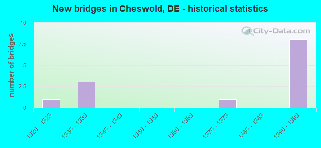
- New bridges - historical statistics
- 11920-1929
- 31930-1939
- 11970-1979
- 81990-1999


- Bridge Condition - Superstructure
- 77.8%Good
- 22.2%Satisfactory

- Bridge Condition - Substructure
- 66.7%Good
- 11.1%Satisfactory
- 22.2%Fair

- Bridge Condition - Channel
- 66.7%Very good
- 11.1%Good
- 11.1%Satisfactory
- 11.1%Fair

- Bridge Condition - Culverts
- 50.0%Satisfactory
- 50.0%Fair
Find on map >> Show street view
Structure Number: 2002C002, Location: S. OF SMYRNA (Lat: 39.244017, Lng: -75.587783), Route carried "on" structure: US 13, Year Built: 1929, Year Reconstructed: 1986, Status: Open, Structure Length: 1.62m (5.31ft), Average Daily Traffic: 15,849 (year 2019), Truck Traffic: 9%, Average Future Daily Traffic: 19,699 (year 2042), Features Intersected: LEIPSIC RIVER
Minimum Vertical Clearance: 30.48m (100.00ft), Kilometerpoint: 19.680, Lanes on structure: 2, Base Highway Network: Yes, Owner: State Highway Agency, Approaching Roadway Width: 10.2m (33.5ft), Material/Design: Concrete, Design/Construction: Slab, Number Of Spans In Main Unit: 3, Length of Maximum Span: 5.6m (18.4ft), Curb-To-Curb Width: 9.9m (32.5ft), Out-to-Out Width: 10.8m (35.4ft)
Condition: Deck: Good, Superstructure: Good, Substructure: Fair, Channel: Satisfactory, Operating Rating: 30.5 metric tons, Method Used To Determine Operating Rating: Load and Resistance Factor Rating (LRFR) rating reported by rating factor(RF) method using HL-93 loadings, Inventory Rating: 23.7 metric tons, Method Used To Determine Inventory Rating: Load and Resistance Factor Rating (LRFR) rating reported by rating factor(RF) method using HL-93 loadings, Structural Evaluation: Somewhat better than minimum adequacy, Deck Geometry: Meets minimum limits, Waterway Adequacy: Equal to present minimum criteria, Approach Roadway Alignment: Equal to present desirable criteria, Designated Inspection Frequency: Every 24 months, Underwater Inspection Frequency: Every 48 months, Inspection Date: October 2020, Underwater Inspection Date: August 2018, Bridge Improvement Cost: $800,000, Roadway Improvement Cost: $200,000, Total Project Cost: $1,000,000
Find on map >> Show street view
Structure Number: 2002D002, Location: GARRISON LAKE (Lat: 39.243819, Lng: -75.588006), Route carried "on" structure: US 13, Year Built: 1934, Year Reconstructed: 1986, Status: Open, Structure Length: 1.66m (5.45ft), Average Daily Traffic: 14,133 (year 2019), Truck Traffic: 9%, Average Future Daily Traffic: 17,566 (year 2042), Features Intersected: LITTLE DUCK CREEK
Minimum Vertical Clearance: 30.48m (100.00ft), Kilometerpoint: 8.851, Lanes on structure: 2, Base Highway Network: Yes, Owner: State Highway Agency, Approaching Roadway Width: 12.3m (40.4ft), Material/Design: Concrete continuous, Design/Construction: Slab, Number Of Spans In Main Unit: 3, Length of Maximum Span: 4.8m (15.7ft), Curb-To-Curb Width: 11.7m (38.4ft), Out-to-Out Width: 12.6m (41.3ft)
Condition: Deck: Good, Superstructure: Good, Substructure: Fair, Channel: Fair, Operating Rating: 30.1 metric tons, Method Used To Determine Operating Rating: Load and Resistance Factor Rating (LRFR) rating reported by rating factor(RF) method using HL-93 loadings, Inventory Rating: 23.3 metric tons, Method Used To Determine Inventory Rating: Load and Resistance Factor Rating (LRFR) rating reported by rating factor(RF) method using HL-93 loadings, Structural Evaluation: Somewhat better than minimum adequacy, Deck Geometry: Better than present minimum criteria, Waterway Adequacy: Equal to present minimum criteria, Approach Roadway Alignment: Equal to present desirable criteria, Designated Inspection Frequency: Every 24 months, Underwater Inspection Frequency: Every 48 months, Inspection Date: October 2020, Underwater Inspection Date: August 2018, Bridge Improvement Cost: $800,000, Roadway Improvement Cost: $200,000, Total Project Cost: $1,000,000, Deck Structure Type: Concrete Cast-file-Place, Wearing Surface/Protective System: Wearing Surface: Bituminous
Find on map >> Show street view
Structure Number: 2014C014, Location: EAST OF CHESWOLD (Lat: 39.227183, Lng: -75.572544), Route carried "on" structure: State highway 42, Year Built: 1991, Status: Open, Structure Length: 6.81m (22.34ft), Average Daily Traffic: 891 (year 2020), Truck Traffic: 7%, Average Future Daily Traffic: 1,107 (year 2043), Design Load: HS 25 or greater, Features Intersected: SR 1/KOREAN WAR VET MEM, Facility Carried by Structure: FAST LANDING RD
Minimum Vertical Clearance: 30.48m (100.00ft), Kilometerpoint: 0.467, Lanes on structure: 2, Lanes under structure: 4, Owner: State Highway Agency, Approaching Roadway Width: 6.8m (22.3ft), Skew: 1 degrees, Material/Design: Steel continuous, Design/Construction: Stringer/Multi-beam, Number Of Spans In Main Unit: 2, Length of Maximum Span: 33.2m (108.9ft), Curb-To-Curb Width: 13.4m (44.0ft), Out-to-Out Width: 14.2m (46.6ft)
Condition: Deck: Good, Superstructure: Good, Substructure: Good, Operating Rating: 38.6 metric tons, Method Used To Determine Operating Rating: Load and Resistance Factor Rating (LRFR) rating reported by rating factor(RF) method using HL-93 loadings, Inventory Rating: 29.8 metric tons, Method Used To Determine Inventory Rating: Load and Resistance Factor Rating (LRFR) rating reported by rating factor(RF) method using HL-93 loadings, Structural Evaluation: Better than present minimum criteria, Deck Geometry: Superior to present desirable criteria, Underclear: Equal to present minimum criteria, Approach Roadway Alignment: Equal to present desirable criteria, Designated Inspection Frequency: Every 24 months, Inspection Date: September 2021, Deck Structure Type: Concrete Cast-file-Place, Wearing Surface/Protective System: Wearing Surface: Monolithic Concrete, Deck Protection: Epoxy Coated Reinforcing
Find on map >> Show street view
Structure Number: 2042A042, Location: MASSEYS MILLPOND (Lat: 39.239447, Lng: -75.617497), Route carried "on" structure: County highway 42, Year Built: 1933, Status: Posted for load, Structure Length: 0.96m (3.15ft), Average Daily Traffic: 1,451 (year 2020), Truck Traffic: 7%, Average Future Daily Traffic: 1,803 (year 2043), Design Load: H 20, Features Intersected: MASSEYS POND/LEIPSIC RIV, Facility Carried by Structure: BRENFORD RD
Minimum Vertical Clearance: 30.48m (100.00ft), Kilometerpoint: 2.816, Lanes on structure: 2, Owner: State Highway Agency, Approaching Roadway Width: 6.3m (20.7ft), Material/Design: Concrete, Design/Construction: Culvert, Number Of Spans In Main Unit: 2, Length of Maximum Span: 4.6m (15.1ft), Curb-To-Curb Width: 8.7m (28.5ft), Out-to-Out Width: 9.6m (31.5ft)
Condition: Channel: Very good, Culverts: Fair, Operating Rating: 22.7 metric tons, Method Used To Determine Operating Rating: Load and Resistance Factor Rating (LRFR) rating reported by rating factor(RF) method using HL-93 loadings, Inventory Rating: 17.5 metric tons, Method Used To Determine Inventory Rating: Load and Resistance Factor Rating (LRFR) rating reported by rating factor(RF) method using HL-93 loadings, Structural Evaluation: Meets minimum limits, Deck Geometry: Somewhat better than minimum adequacy, Waterway Adequacy: Better than present minimum criteria, Approach Roadway Alignment: Equal to present desirable criteria, Bridge Posting: Required (Relationship of Operating Rating to Maximum Legal Load: 30.0 - 39.9% below), Designated Inspection Frequency: Every 24 months, Inspection Date: July 2021
Find on map >> Show street view
Structure Number: 2091A091, Location: EAST OF KENTON (Lat: 39.232689, Lng: -75.632250), Route carried "on" structure: State highway 15, Year Built: 1978, Status: Open, Structure Length: 1.34m (4.40ft), Average Daily Traffic: 2,073 (year 2020), Truck Traffic: 13%, Average Future Daily Traffic: 2,576 (year 2043), Design Load: HS 20, Features Intersected: LEIPSIC RIVER, Facility Carried by Structure: MT FRIENDSHIP RD
Minimum Vertical Clearance: 30.48m (100.00ft), Kilometerpoint: 1.030, Lanes on structure: 2, Owner: State Highway Agency, Approaching Roadway Width: 8.8m (28.9ft), Skew: 3 degrees, Material/Design: Steel, Design/Construction: Culvert, Number Of Spans In Main Unit: 3, Length of Maximum Span: 3.3m (10.8ft)
Condition: Channel: Good, Culverts: Satisfactory, Operating Rating: 54.4 metric tons, Method Used To Determine Operating Rating: Field evaluation and documented engineering judgment, Inventory Rating: 32.7 metric tons, Method Used To Determine Inventory Rating: Field evaluation and documented engineering judgment, Structural Evaluation: Equal to present minimum criteria, Waterway Adequacy: Better than present minimum criteria, Approach Roadway Alignment: Equal to present desirable criteria, Designated Inspection Frequency: Every 24 months, Inspection Date: August 2021
Find on map >> Show street view
Structure Number: 2104C104, Location: SOUTH OF CHESWOLD (Lat: 39.197578, Lng: -75.596728), Route carried "on" structure: State highway 15, Year Built: 1934, Status: Open, Structure Length: 0.79m (2.59ft), Average Daily Traffic: 5,460 (year 2019), Truck Traffic: 10%, Average Future Daily Traffic: 6,786 (year 2042), Design Load: H 20, Features Intersected: FORK BRANCH
Minimum Vertical Clearance: 30.48m (100.00ft), Kilometerpoint: 5.858, Lanes on structure: 2, Owner: State Highway Agency, Approaching Roadway Width: 8.0m (26.2ft), Material/Design: Concrete, Design/Construction: Slab, Number Of Spans In Main Unit: 1, Length of Maximum Span: 6.7m (22.0ft), Curb-To-Curb Width: 9.8m (32.2ft), Out-to-Out Width: 10.7m (35.1ft)
Condition: Deck: Good, Superstructure: Good, Substructure: Satisfactory, Channel: Very good, Operating Rating: 31.4 metric tons, Method Used To Determine Operating Rating: Load and Resistance Factor Rating (LRFR) rating reported by rating factor(RF) method using HL-93 loadings, Inventory Rating: 24.3 metric tons, Method Used To Determine Inventory Rating: Load and Resistance Factor Rating (LRFR) rating reported by rating factor(RF) method using HL-93 loadings, Structural Evaluation: Equal to present minimum criteria, Deck Geometry: Meets minimum limits, Waterway Adequacy: Better than present minimum criteria, Approach Roadway Alignment: Equal to present desirable criteria, Designated Inspection Frequency: Every 24 months, Inspection Date: October 2020, Bridge Improvement Cost: $800,000, Roadway Improvement Cost: $200,000, Total Project Cost: $1,000,000, Deck Structure Type: Concrete Cast-file-Place, Wearing Surface/Protective System: Wearing Surface: Bituminous
Find on map >> Show street view
Structure Number: 2345 345, Location: EAST OF CHESWOLD (Lat: 39.221503, Lng: -75.564997), Route carried "on" structure: County highway 345, Year Built: 1991, Status: Open, Structure Length: 7.60m (24.93ft), Average Daily Traffic: 699 (year 2019), Truck Traffic: 10%, Average Future Daily Traffic: 868 (year 2042), Design Load: HS 25 or greater, Features Intersected: SR 1, Facility Carried by Structure: SIMMS WOODS RD
Minimum Vertical Clearance: 30.48m (100.00ft), Kilometerpoint: 0.805, Lanes on structure: 2, Lanes under structure: 4, Owner: State Highway Agency, Approaching Roadway Width: 13.4m (44.0ft), Skew: 3 degrees, Material/Design: Steel continuous, Design/Construction: Stringer/Multi-beam, Number Of Spans In Main Unit: 2, Length of Maximum Span: 37.2m (122.0ft), Curb-To-Curb Width: 13.4m (44.0ft), Out-to-Out Width: 14.2m (46.6ft)
Condition: Deck: Good, Superstructure: Good, Substructure: Good, Operating Rating: 57.9 metric tons, Method Used To Determine Operating Rating: Load Factor (LF), Inventory Rating: 41.8 metric tons, Method Used To Determine Inventory Rating: Load Factor (LF), Structural Evaluation: Better than present minimum criteria, Deck Geometry: Superior to present desirable criteria, Underclear: Better than present minimum criteria, Approach Roadway Alignment: Equal to present desirable criteria, Designated Inspection Frequency: Every 24 months, Inspection Date: September 2020, Deck Structure Type: Concrete Cast-file-Place, Wearing Surface/Protective System: Wearing Surface: Monolithic Concrete, Deck Protection: Epoxy Coated Reinforcing
Find on map >> Show street view
Structure Number: 2919N15, Location: EAST OF GARRISONS LAKE (Lat: 39.242039, Lng: -75.581583), Route carried "on" structure: State highway 1, Year Built: 1992, Status: Open, Structure Length: 18.04m (59.19ft), Average Daily Traffic: 21,018 (year 2020), Truck Traffic: 9%, Average Future Daily Traffic: 26,123 (year 2043), Design Load: HS 25 or greater, Features Intersected: LEIPSIC RIVER, Facility Carried by Structure: KOREAN WAR VET HWY
Minimum Vertical Clearance: 30.48m (100.00ft), Kilometerpoint: 17.268, Lanes on structure: 2, Base Highway Network: Yes, Toll: On toll road, Owner: State Highway Agency, Approaching Roadway Width: 11.9m (39.0ft), Material/Design: Prestressed concrete, Design/Construction: Stringer/Multi-beam, Number Of Spans In Main Unit: 9, Length of Maximum Span: 18.7m (61.4ft), Curb-To-Curb Width: 14.6m (47.9ft), Out-to-Out Width: 15.4m (50.5ft)
Condition: Deck: Good, Superstructure: Satisfactory, Substructure: Good, Channel: Very good, Operating Rating: 62.5 metric tons, Method Used To Determine Operating Rating: Load and Resistance Factor Rating (LRFR) rating reported by rating factor(RF) method using HL-93 loadings, Inventory Rating: 46.0 metric tons, Method Used To Determine Inventory Rating: Load and Resistance Factor Rating (LRFR) rating reported by rating factor(RF) method using HL-93 loadings, Structural Evaluation: Equal to present minimum criteria, Deck Geometry: Superior to present desirable criteria, Waterway Adequacy: Superior to present desirable criteria, Approach Roadway Alignment: Equal to present desirable criteria, Designated Inspection Frequency: Every 24 months, Inspection Date: September 2021, Deck Structure Type: Concrete Cast-file-Place, Wearing Surface/Protective System: Wearing Surface: Monolithic Concrete, Deck Protection: Epoxy Coated Reinforcing
Find on map >> Show street view
Structure Number: 2919S15, Location: EAST OF GARRISONS LAKE (Lat: 39.242156, Lng: -75.581894), Route carried "on" structure: State highway 1, Year Built: 1992, Status: Open, Structure Length: 20.03m (65.72ft), Average Daily Traffic: 21,018 (year 2020), Truck Traffic: 9%, Average Future Daily Traffic: 26,123 (year 2043), Design Load: HS 25 or greater, Features Intersected: LEIPSIC RIVER, Facility Carried by Structure: KOREAN WAR VET HWY
Minimum Vertical Clearance: 30.48m (100.00ft), Kilometerpoint: 33.120, Lanes on structure: 2, Base Highway Network: Yes, Toll: On toll road, Owner: State Highway Agency, Approaching Roadway Width: 11.9m (39.0ft), Material/Design: Prestressed concrete continuous, Design/Construction: Stringer/Multi-beam, Number Of Spans In Main Unit: 10, Length of Maximum Span: 18.7m (61.4ft), Curb-To-Curb Width: 14.6m (47.9ft), Out-to-Out Width: 15.4m (50.5ft)
Condition: Deck: Good, Superstructure: Satisfactory, Substructure: Good, Channel: Very good, Operating Rating: 62.5 metric tons, Method Used To Determine Operating Rating: Load and Resistance Factor Rating (LRFR) rating reported by rating factor(RF) method using HL-93 loadings, Inventory Rating: 46.0 metric tons, Method Used To Determine Inventory Rating: Load and Resistance Factor Rating (LRFR) rating reported by rating factor(RF) method using HL-93 loadings, Structural Evaluation: Equal to present minimum criteria, Deck Geometry: Superior to present desirable criteria, Waterway Adequacy: Superior to present desirable criteria, Approach Roadway Alignment: Equal to present desirable criteria, Designated Inspection Frequency: Every 24 months, Inspection Date: September 2021, Deck Structure Type: Concrete Cast-file-Place, Wearing Surface/Protective System: Wearing Surface: Monolithic Concrete, Deck Protection: Epoxy Coated Reinforcing
Find on map >> Show street view
Structure Number: 2927N15, Location: NORTH OF CHESWOLD (Lat: 39.234022, Lng: -75.578442), Route carried "on" structure: State highway 1, Year Built: 1993, Status: Open, Structure Length: 7.53m (24.70ft), Average Daily Traffic: 21,019 (year 2020), Truck Traffic: 9%, Average Future Daily Traffic: 26,125 (year 2043), Design Load: HS 25 or greater, Features Intersected: ALSTON BRANCH, Facility Carried by Structure: KOREAN WAR VET MEM
Minimum Vertical Clearance: 30.48m (100.00ft), Kilometerpoint: 16.270, Lanes on structure: 2, Base Highway Network: Yes, Toll: On toll road, Owner: State Highway Agency, Approaching Roadway Width: 12.2m (40.0ft), Material/Design: Prestressed concrete continuous, Design/Construction: Stringer/Multi-beam, Number Of Spans In Main Unit: 4, Length of Maximum Span: 18.0m (59.1ft), Curb-To-Curb Width: 14.7m (48.2ft), Out-to-Out Width: 15.6m (51.2ft)
Condition: Deck: Good, Superstructure: Good, Substructure: Good, Channel: Very good, Operating Rating: 61.9 metric tons, Method Used To Determine Operating Rating: Load and Resistance Factor Rating (LRFR) rating reported by rating factor(RF) method using HL-93 loadings, Inventory Rating: 47.3 metric tons, Method Used To Determine Inventory Rating: Load and Resistance Factor Rating (LRFR) rating reported by rating factor(RF) method using HL-93 loadings, Structural Evaluation: Better than present minimum criteria, Deck Geometry: Superior to present desirable criteria, Waterway Adequacy: Equal to present desirable criteria, Approach Roadway Alignment: Equal to present desirable criteria, Designated Inspection Frequency: Every 24 months, Inspection Date: October 2021, Deck Structure Type: Concrete Cast-file-Place, Wearing Surface/Protective System: Wearing Surface: Monolithic Concrete, Deck Protection: Epoxy Coated Reinforcing
Find on map >> Show street view
Structure Number: 2927S15, Location: NORTH OF CHESWOLD (Lat: 39.233711, Lng: -75.578583), Route carried "on" structure: State highway 1, Year Built: 1992, Status: Open, Structure Length: 7.53m (24.70ft), Average Daily Traffic: 21,019 (year 2020), Truck Traffic: 9%, Average Future Daily Traffic: 26,125 (year 2043), Design Load: HS 25 or greater, Features Intersected: ALSTON BRANCH, Facility Carried by Structure: KOREAN WAR VET MEM
Minimum Vertical Clearance: 30.48m (100.00ft), Kilometerpoint: 34.054, Lanes on structure: 2, Base Highway Network: Yes, Toll: On toll road, Owner: State Highway Agency, Approaching Roadway Width: 12.2m (40.0ft), Material/Design: Prestressed concrete continuous, Design/Construction: Stringer/Multi-beam, Number Of Spans In Main Unit: 4, Length of Maximum Span: 18.0m (59.1ft), Curb-To-Curb Width: 14.7m (48.2ft), Out-to-Out Width: 15.6m (51.2ft)
Condition: Deck: Good, Superstructure: Good, Substructure: Good, Channel: Very good, Operating Rating: 61.9 metric tons, Method Used To Determine Operating Rating: Load and Resistance Factor Rating (LRFR) rating reported by rating factor(RF) method using HL-93 loadings, Inventory Rating: 47.3 metric tons, Method Used To Determine Inventory Rating: Load and Resistance Factor Rating (LRFR) rating reported by rating factor(RF) method using HL-93 loadings, Structural Evaluation: Better than present minimum criteria, Deck Geometry: Superior to present desirable criteria, Waterway Adequacy: Equal to present desirable criteria, Approach Roadway Alignment: Equal to present desirable criteria, Designated Inspection Frequency: Every 24 months, Inspection Date: October 2021, Deck Structure Type: Concrete Cast-file-Place, Wearing Surface/Protective System: Wearing Surface: Monolithic Concrete, Deck Protection: Epoxy Coated Reinforcing
Find on map >> Show street view
Structure Number: 2014C014, Location: EAST OF CHESWOLD (Lat: 39.227183, Lng: -75.572544), Route carried "under" structure: State highway 1, Year Built: 1991, Structure Length: 0. m, Average Daily Traffic: 42,037 (year 2020), Truck Traffic: 9%, Features Intersected: SR 1/KOREAN WAR VET MEM, Facility Carried by Structure: FAST LANDING RD
Minimum Vertical Clearance: 5.37m (17.62ft), Kilometerpoint: 15.401, Lanes on structure: 2, Lanes under structure: 4, Toll: On toll road, Material/Design: Steel continuous, Design/Construction: Stringer/Multi-beam, Length of Maximum Span: 33.2m (108.9ft)
Find on map >> Show street view
Structure Number: 2345 345, Location: EAST OF CHESWOLD (Lat: 39.221503, Lng: -75.564997), Route carried "under" structure: State highway 1, Year Built: 1991, Structure Length: 0. m, Average Daily Traffic: 52,877 (year 2019), Truck Traffic: 10%, Features Intersected: SR 1, Facility Carried by Structure: SIMMS WOODS RD
Minimum Vertical Clearance: 5.31m (17.42ft), Kilometerpoint: 13.600, Lanes on structure: 2, Lanes under structure: 4, Toll: On toll road, Material/Design: Steel continuous, Design/Construction: Stringer/Multi-beam, Length of Maximum Span: 37.2m (122.0ft)