Bridge Statistics for Choccolocco, Alabama (AL)
Condition, Traffic, Stress, Structural Evaluation, Project Costs
- National Bridge Inventory (NBI) Statistics
- 19Number of bridges
- 128ft / 38.6mTotal length
- $10,670,000Total costs
- 18,547Total average daily traffic
- 495Total average daily truck traffic
- 31,523Total future (year 2039) average daily traffic
- National Bridge Inventory (NBI) Registered Bridges for Choccolocco
- No street view available for this location
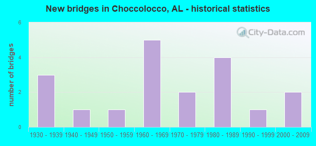
- New bridges - historical statistics
- 31930-1939
- 11940-1949
- 11950-1959
- 51960-1969
- 21970-1979
- 41980-1989
- 11990-1999
- 22000-2009


- Bridge Condition - Deck
- 41.7%Very good
- 33.3%Good
- 16.7%Satisfactory
- 8.3%Fair

- Bridge Condition - Superstructure
- 33.3%Very good
- 41.7%Good
- 16.7%Satisfactory
- 8.3%Fair

- Bridge Condition - Substructure
- 33.3%Very good
- 8.3%Good
- 33.3%Satisfactory
- 25.0%Fair

- Bridge Condition - Channel
- 5.3%Very good
- 57.9%Good
- 26.3%Satisfactory
- 10.5%Fair

- Bridge Condition - Culverts
- 57.1%Good
- 42.9%Satisfactory
Find on map >> Show street view
Structure Number: 119, Location: CHOSEA SPRINGS RD. EAST (Lat: 33.694092, Lng: -85.674008), Route carried "on" structure: County highway 6, Year Built: 1935, Status: Open, Structure Length: 1.01m (3.31ft), Average Daily Traffic: 194 (year 2020), Truck Traffic: 2%, Average Future Daily Traffic: 288 (year 2040), Features Intersected: BRANCH, Facility Carried by Structure: CHOSEA SPR. RD. E
Minimum Vertical Clearance: 30+ m (98+ ft), Kilometerpoint: 0.010, Lanes on structure: 2, Owner: County Highway Agency, Approaching Roadway Width: 7.3m (24.0ft), Skew: 4 degrees, Material/Design: Concrete, Design/Construction: Slab, Number Of Spans In Main Unit: 2, Length of Maximum Span: 2.1m (6.9ft), Curb-To-Curb Width: 7.3m (24.0ft), Out-to-Out Width: 7.3m (24.0ft)
Condition: Deck: Good, Superstructure: Good, Substructure: Satisfactory, Channel: Satisfactory, Operating Rating: 43.5 metric tons, Method Used To Determine Operating Rating: Field evaluation and documented engineering judgment, Inventory Rating: 32.7 metric tons, Method Used To Determine Inventory Rating: Field evaluation and documented engineering judgment, Structural Evaluation: Equal to present minimum criteria, Deck Geometry: Somewhat better than minimum adequacy, Waterway Adequacy: Equal to present minimum criteria, Approach Roadway Alignment: Equal to present minimum criteria, Length Of Structure Improvement: 1.68m (5.51ft), Designated Inspection Frequency: Every 24 months, Inspection Date: November 2020, Bridge Improvement Cost: $277,000, Roadway Improvement Cost: $28,000, Total Project Cost: $305,000 ( Estimate for 2022), Deck Structure Type: Concrete Cast-file-Place, Wearing Surface/Protective System: Wearing Surface: Bituminous
Find on map >> Show street view
Structure Number: 1198, Location: IRON CITY CUTOFF (Lat: 33.664144, Lng: -85.687428), Route carried "on" structure: County highway 8, Year Built: 1935, Year Reconstructed: 1993, Status: Open, Structure Length: 7.47m (24.51ft), Average Daily Traffic: 345 (year 1993), Truck Traffic: 1%, Average Future Daily Traffic: 475 (year 2040), Design Load: HS 20, Features Intersected: CHOCCOLOCCO CREEK, Facility Carried by Structure: IRON CITY CUTOFF
Minimum Vertical Clearance: 30+ m (98+ ft), Kilometerpoint: 0.010, Lanes on structure: 2, Owner: County Highway Agency, Approaching Roadway Width: 6.7m (22.0ft), Material/Design: Prestressed concrete, Design/Construction: Stringer/Multi-beam, Number Of Spans In Main Unit: 6, Length of Maximum Span: 22.9m (75.1ft), Curb-To-Curb Width: 8.5m (27.9ft), Out-to-Out Width: 9.4m (30.8ft)
Condition: Deck: Very good, Superstructure: Very good, Substructure: Very good, Channel: Good, Operating Rating: 55.2 metric tons, Method Used To Determine Operating Rating: Load Factor (LF), Inventory Rating: 33.1 metric tons, Method Used To Determine Inventory Rating: Load Factor (LF), Structural Evaluation: Equal to present desirable criteria, Deck Geometry: Equal to present minimum criteria, Waterway Adequacy: Equal to present desirable criteria, Approach Roadway Alignment: Equal to present desirable criteria, Length Of Structure Improvement: 8.49m (27.85ft), Designated Inspection Frequency: Every 24 months, Inspection Date: September 2020, Bridge Improvement Cost: $1,747,000, Roadway Improvement Cost: $175,000, Total Project Cost: $1,922,000 ( Estimate for 2022), Deck Structure Type: Concrete Cast-file-Place
Find on map >> Show street view
Structure Number: 1914, Location: RIDDLE FARM RD. (Lat: 33.638883, Lng: -85.690653), Route carried "on" structure: County highway 9, Year Built: 1939, Status: Open, Structure Length: 1.46m (4.79ft), Average Daily Traffic: 150 (year 2001), Truck Traffic: 5%, Average Future Daily Traffic: 324 (year 2040), Features Intersected: EGONIAGA CREEK, Facility Carried by Structure: RIDDLE FARM RD.
Minimum Vertical Clearance: 30+ m (98+ ft), Kilometerpoint: 0.010, Lanes on structure: 1, Owner: County Highway Agency, Approaching Roadway Width: 4.6m (15.1ft), Skew: 1 degrees, Material/Design: Concrete, Design/Construction: Slab, Number Of Spans In Main Unit: 3, Length of Maximum Span: 4.9m (16.1ft), Curb-To-Curb Width: 3.7m (12.1ft), Out-to-Out Width: 4.0m (13.1ft)
Condition: Deck: Fair, Superstructure: Fair, Substructure: Fair, Channel: Fair, Operating Rating: 32.7 metric tons, Method Used To Determine Operating Rating: Field evaluation and documented engineering judgment, Inventory Rating: 24.5 metric tons, Method Used To Determine Inventory Rating: Field evaluation and documented engineering judgment, Structural Evaluation: Somewhat better than minimum adequacy, Deck Geometry: High priority of replacement, Waterway Adequacy: Better than present minimum criteria, Approach Roadway Alignment: Somewhat better than minimum adequacy, Length Of Structure Improvement: 2.14m (7.02ft), Designated Inspection Frequency: Every 24 months, Inspection Date: November 2020, Bridge Improvement Cost: $191,000, Roadway Improvement Cost: $19,000, Total Project Cost: $210,000 ( Estimate for 2022), Deck Structure Type: Concrete Cast-file-Place
Find on map >> Show street view
Structure Number: 2428, Location: WHITE PLAINS (Lat: 33.755322, Lng: -85.686206), Route carried "on" structure: County highway 85, Year Built: 1940, Status: Open, Structure Length: 1.37m (4.49ft), Average Daily Traffic: 401 (year 2010), Truck Traffic: 8%, Average Future Daily Traffic: 726 (year 2040), Features Intersected: COTTAQUILLA CREEK, Facility Carried by Structure: RED ROAD 55
Minimum Vertical Clearance: 7.56m (24.80ft), Kilometerpoint: 0.010, Lanes on structure: 2, Owner: County Highway Agency, Approaching Roadway Width: 6.7m (22.0ft), Material/Design: Steel, Design/Construction: Stringer/Multi-beam, Number Of Spans In Main Unit: 1, Length of Maximum Span: 13.7m (44.9ft), Curb-To-Curb Width: 5.8m (19.0ft), Out-to-Out Width: 6.1m (20.0ft)
Condition: Deck: Good, Superstructure: Satisfactory, Substructure: Satisfactory, Channel: Satisfactory, Operating Rating: 44.1 metric tons, Method Used To Determine Operating Rating: Load Factor (LF), Inventory Rating: 26.4 metric tons, Method Used To Determine Inventory Rating: Load Factor (LF), Structural Evaluation: Equal to present minimum criteria, Deck Geometry: High priority of replacement, Waterway Adequacy: Superior to present desirable criteria, Approach Roadway Alignment: Superior to present desirable criteria, Length Of Structure Improvement: 2.04m (6.69ft), Designated Inspection Frequency: Every 24 months, Inspection Date: November 2020, Bridge Improvement Cost: $280,000, Roadway Improvement Cost: $28,000, Total Project Cost: $308,000 ( Estimate for 2022), Deck Structure Type: Concrete Cast-file-Place, Wearing Surface/Protective System: Wearing Surface: Bituminous
Find on map >> Show street view
Structure Number: 7948, Location: FRIENDSHIP RD. (Lat: 33.585850, Lng: -85.772697), Route carried "on" structure: County highway 18, Year Built: 1963, Status: Open, Structure Length: 0.94m (3.08ft), Average Daily Traffic: 1,850 (year 1993), Truck Traffic: 5%, Average Future Daily Traffic: 2,750 (year 2040), Design Load: H 15, Features Intersected: CREEK, Facility Carried by Structure: FRIENDSHIP RD.
Minimum Vertical Clearance: 30+ m (98+ ft), Kilometerpoint: 0.010, Lanes on structure: 2, Owner: County Highway Agency, Approaching Roadway Width: 8.5m (27.9ft), Material/Design: Concrete, Design/Construction: Culvert, Number Of Spans In Main Unit: 3, Length of Maximum Span: 3.0m (9.8ft)
Condition: Channel: Satisfactory, Culverts: Satisfactory, Operating Rating: 77.5 metric tons, Method Used To Determine Operating Rating: Load Factor (LF), Inventory Rating: 46.4 metric tons, Method Used To Determine Inventory Rating: Load Factor (LF), Structural Evaluation: Equal to present minimum criteria, Waterway Adequacy: Better than present minimum criteria, Approach Roadway Alignment: Equal to present desirable criteria, Length Of Structure Improvement: 1.61m (5.28ft), Designated Inspection Frequency: Every 24 months, Inspection Date: September 2020, Bridge Improvement Cost: $288,000, Roadway Improvement Cost: $29,000, Total Project Cost: $317,000 ( Estimate for 2022)
Find on map >> Show street view
Structure Number: 8051, Location: CHOCCOLOCCO RD (Lat: 33.678622, Lng: -85.698569), Route carried "on" structure: County highway 85, Year Built: 1963, Status: Open, Structure Length: 0.80m (2.62ft), Average Daily Traffic: 1,717 (year 2009), Truck Traffic: 1%, Average Future Daily Traffic: 3,172 (year 2040), Design Load: H 15, Features Intersected: BRANCH, Facility Carried by Structure: CHOCCOLOCCO RD.
Minimum Vertical Clearance: 30+ m (98+ ft), Kilometerpoint: 0.010, Lanes on structure: 2, Owner: County Highway Agency, Approaching Roadway Width: 9.4m (30.8ft), Material/Design: Concrete, Design/Construction: Culvert, Number Of Spans In Main Unit: 3, Length of Maximum Span: 2.4m (7.9ft)
Condition: Channel: Good, Culverts: Good, Operating Rating: 88.9 metric tons, Method Used To Determine Operating Rating: Load Factor (LF), Inventory Rating: 63.7 metric tons, Method Used To Determine Inventory Rating: Load Factor (LF), Structural Evaluation: Better than present minimum criteria, Waterway Adequacy: Superior to present desirable criteria, Approach Roadway Alignment: Equal to present desirable criteria, Length Of Structure Improvement: 1.45m (4.76ft), Designated Inspection Frequency: Every 24 months, Inspection Date: November 2020, Bridge Improvement Cost: $353,000, Roadway Improvement Cost: $35,000, Total Project Cost: $388,000 ( Estimate for 2022)
Find on map >> Show street view
Structure Number: 8052, Location: CHOCCOLOCCO RD. (Lat: 33.705267, Lng: -85.698114), Route carried "on" structure: County highway 85, Year Built: 1963, Status: Open, Structure Length: 0.80m (2.62ft), Average Daily Traffic: 1,717 (year 2009), Truck Traffic: 1%, Average Future Daily Traffic: 3,172 (year 2040), Design Load: H 15, Features Intersected: BRANCH, Facility Carried by Structure: CHOCCOLOCCO RD.
Minimum Vertical Clearance: 30+ m (98+ ft), Kilometerpoint: 0.010, Lanes on structure: 2, Owner: County Highway Agency, Approaching Roadway Width: 8.5m (27.9ft), Material/Design: Concrete, Design/Construction: Culvert, Number Of Spans In Main Unit: 3, Length of Maximum Span: 2.4m (7.9ft)
Condition: Channel: Satisfactory, Culverts: Satisfactory, Operating Rating: 49.3 metric tons, Method Used To Determine Operating Rating: Load Factor (LF), Inventory Rating: 29.6 metric tons, Method Used To Determine Inventory Rating: Load Factor (LF), Structural Evaluation: Equal to present minimum criteria, Waterway Adequacy: Equal to present desirable criteria, Approach Roadway Alignment: Equal to present desirable criteria, Length Of Structure Improvement: 1.45m (4.76ft), Designated Inspection Frequency: Every 24 months, Inspection Date: November 2020, Bridge Improvement Cost: $378,000, Roadway Improvement Cost: $38,000, Total Project Cost: $416,000 ( Estimate for 2022)
Find on map >> Show street view
Structure Number: 8053, Location: CHOCCOLOCCO RD. (Lat: 33.740569, Lng: -85.689858), Route carried "on" structure: County highway 85, Year Built: 1963, Status: Open, Structure Length: 0.85m (2.79ft), Average Daily Traffic: 1,717 (year 2009), Truck Traffic: 1%, Average Future Daily Traffic: 3,172 (year 2040), Design Load: H 15, Features Intersected: BRANCH, Facility Carried by Structure: CHOCCOLOCCO RD.
Minimum Vertical Clearance: 30+ m (98+ ft), Kilometerpoint: 0.010, Lanes on structure: 2, Owner: County Highway Agency, Approaching Roadway Width: 9.1m (29.9ft), Material/Design: Concrete, Design/Construction: Culvert, Number Of Spans In Main Unit: 3, Length of Maximum Span: 2.4m (7.9ft)
Condition: Channel: Satisfactory, Culverts: Satisfactory, Operating Rating: 43.8 metric tons, Method Used To Determine Operating Rating: Load Factor (LF), Inventory Rating: 26.3 metric tons, Method Used To Determine Inventory Rating: Load Factor (LF), Structural Evaluation: Equal to present minimum criteria, Waterway Adequacy: Equal to present minimum criteria, Approach Roadway Alignment: Equal to present desirable criteria, Length Of Structure Improvement: 1.52m (4.99ft), Designated Inspection Frequency: Every 24 months, Inspection Date: November 2020, Bridge Improvement Cost: $368,000, Roadway Improvement Cost: $37,000, Total Project Cost: $405,000 ( Estimate for 2022)
Find on map >> Show street view
Structure Number: 8724, Location: JEWELL RD. (Lat: 33.586275, Lng: -85.746000), Route carried "on" structure: County highway 18, Year Built: 1965, Status: Open, Structure Length: 0.79m (2.59ft), Average Daily Traffic: 15 (year 1993), Average Future Daily Traffic: 20 (year 2040), Features Intersected: LITTLE HILLABEE CREEK, Facility Carried by Structure: JEWELL RD.
Minimum Vertical Clearance: 30+ m (98+ ft), Kilometerpoint: 0.010, Lanes on structure: 1, Owner: County Highway Agency, Approaching Roadway Width: 4.6m (15.1ft), Skew: 1 degrees, Material/Design: Steel continuous, Design/Construction: Stringer/Multi-beam, Number Of Spans In Main Unit: 2, Length of Maximum Span: 4.0m (13.1ft), Curb-To-Curb Width: 4.0m (13.1ft), Out-to-Out Width: 4.0m (13.1ft)
Condition: Deck: Satisfactory, Superstructure: Good, Substructure: Satisfactory, Channel: Good, Operating Rating: 51.5 metric tons, Method Used To Determine Operating Rating: Load Factor (LF), Inventory Rating: 31.5 metric tons, Method Used To Determine Inventory Rating: Load Factor (LF), Structural Evaluation: Equal to present minimum criteria, Deck Geometry: Somewhat better than minimum adequacy, Waterway Adequacy: Equal to present minimum criteria, Approach Roadway Alignment: Meets minimum limits, Length Of Structure Improvement: 1.44m (4.72ft), Designated Inspection Frequency: Every 24 months, Inspection Date: September 2020, Bridge Improvement Cost: $129,000, Roadway Improvement Cost: $13,000, Total Project Cost: $142,000 ( Estimate for 2022), Deck Structure Type: Wood or Timber, Wearing Surface/Protective System: Wearing Surface: Wood or Timber
Find on map >> Show street view
Structure Number: 11226, Location: MELLON BRIDGE RD (Lat: 33.600011, Lng: -85.757283), Route carried "on" structure: County highway 24, Year Built: 1974, Status: Open, Structure Length: 2.74m (8.99ft), Average Daily Traffic: 1,388 (year 2019), Truck Traffic: 2%, Average Future Daily Traffic: 2,104 (year 2040), Features Intersected: CHOCCOLOCCO CREEK, Facility Carried by Structure: MELLON BRIDGE RD.
Minimum Vertical Clearance: 30+ m (98+ ft), Kilometerpoint: 0.010, Lanes on structure: 1, Owner: County Highway Agency, Approaching Roadway Width: 8.8m (28.9ft), Material/Design: Steel, Design/Construction: Stringer/Multi-beam, Number Of Spans In Main Unit: 3, Length of Maximum Span: 9.1m (29.9ft), Curb-To-Curb Width: 4.7m (15.4ft), Out-to-Out Width: 4.7m (15.4ft)
Condition: Deck: Satisfactory, Superstructure: Good, Substructure: Fair, Channel: Fair, Operating Rating: 59.5 metric tons, Method Used To Determine Operating Rating: Allowable Stress (AS), Inventory Rating: 42.4 metric tons, Method Used To Determine Inventory Rating: Allowable Stress (AS), Structural Evaluation: Somewhat better than minimum adequacy, Deck Geometry: High priority of replacement, Waterway Adequacy: Equal to present minimum criteria, Approach Roadway Alignment: Meets minimum limits, Length Of Structure Improvement: 3.66m (12.01ft), Designated Inspection Frequency: Every 24 months, Inspection Date: November 2020, Bridge Improvement Cost: $376,000, Roadway Improvement Cost: $38,000, Total Project Cost: $414,000 ( Estimate for 2022), Deck Structure Type: Wood or Timber, Wearing Surface/Protective System: Wearing Surface: Wood or Timber
Find on map >> Show street view
Structure Number: 11806, Location: FRIENDSHIP RD. (Lat: 33.587017, Lng: -85.756475), Route carried "on" structure: County highway 18, Year Built: 1977, Status: Open, Structure Length: 2.07m (6.79ft), Average Daily Traffic: 4,147 (year 2009), Average Future Daily Traffic: 7,662 (year 2040), Features Intersected: BIG HILLABEE CREEK, Facility Carried by Structure: FRIENDSHIP RD.
Minimum Vertical Clearance: 30+ m (98+ ft), Kilometerpoint: 0.010, Lanes on structure: 2, Owner: County Highway Agency, Approaching Roadway Width: 8.5m (27.9ft), Material/Design: Concrete, Design/Construction: Channel Beam, Number Of Spans In Main Unit: 2, Length of Maximum Span: 10.4m (34.1ft), Curb-To-Curb Width: 8.5m (27.9ft), Out-to-Out Width: 9.1m (29.9ft)
Condition: Deck: Good, Superstructure: Satisfactory, Substructure: Fair, Channel: Good, Operating Rating: 41.9 metric tons, Method Used To Determine Operating Rating: Load Factor (LF), Inventory Rating: 25.1 metric tons, Method Used To Determine Inventory Rating: Load Factor (LF), Structural Evaluation: Somewhat better than minimum adequacy, Deck Geometry: Meets minimum limits, Approach Roadway Alignment: Equal to present minimum criteria, Length Of Structure Improvement: 2.84m (9.32ft), Designated Inspection Frequency: Every 24 months, Inspection Date: December 2020, Bridge Improvement Cost: $564,000, Roadway Improvement Cost: $56,000, Total Project Cost: $620,000 ( Estimate for 2022), Deck Structure Type: Concrete Precast Panels, Wearing Surface/Protective System: Wearing Surface: Bituminous
Find on map >> Show street view
Structure Number: 1363, Location: MELLON BRIDGE RD. (Lat: 33.589256, Lng: -85.753381), Route carried "on" structure: County highway 24, Year Built: 1985, Status: Open, Structure Length: 1.22m (4.00ft), Average Daily Traffic: 1,388 (year 2019), Truck Traffic: 2%, Average Future Daily Traffic: 2,104 (year 2040), Design Load: HS 20, Features Intersected: LITTLE HILLABEE CREEK, Facility Carried by Structure: MELLON BRIDGE RD.
Minimum Vertical Clearance: 30+ m (98+ ft), Kilometerpoint: 0.010, Lanes on structure: 2, Owner: County Highway Agency, Approaching Roadway Width: 8.5m (27.9ft), Material/Design: Concrete, Design/Construction: Culvert, Number Of Spans In Main Unit: 2, Length of Maximum Span: 3.0m (9.8ft), Curb-To-Curb Width: 12.2m (40.0ft), Out-to-Out Width: 12.2m (40.0ft)
Condition: Channel: Good, Culverts: Good, Operating Rating: 88.9 metric tons, Method Used To Determine Operating Rating: Load Factor (LF), Inventory Rating: 55.0 metric tons, Method Used To Determine Inventory Rating: Load Factor (LF), Structural Evaluation: Better than present minimum criteria, Deck Geometry: Better than present minimum criteria, Waterway Adequacy: Equal to present desirable criteria, Approach Roadway Alignment: Better than present minimum criteria, Length Of Structure Improvement: 1.89m (6.20ft), Designated Inspection Frequency: Every 24 months, Inspection Date: November 2020, Bridge Improvement Cost: $437,000, Roadway Improvement Cost: $44,000, Total Project Cost: $481,000 ( Estimate for 2022)
Find on map >> Show street view
Structure Number: 14102, Location: RAINBOW DR. CONC 1987 (Lat: 33.744269, Lng: -85.669469), Route carried "on" structure: County highway 132, Year Built: 1958, Year Reconstructed: 1987, Status: Open, Structure Length: 5.97m (19.59ft), Average Daily Traffic: 402 (year 2015), Truck Traffic: 1%, Average Future Daily Traffic: 673 (year 2041), Design Load: HS 20, Features Intersected: CHOCCOLOCCO CREEK, Facility Carried by Structure: 1 MI E ALA 9
Minimum Vertical Clearance: 30+ m (98+ ft), Kilometerpoint: 0.000, Lanes on structure: 2, Owner: County Highway Agency, Approaching Roadway Width: 9.1m (29.9ft), Material/Design: Prestressed concrete, Design/Construction: Stringer/Multi-beam, Number Of Spans In Main Unit: 1, Number Of Approach Spans: 4, Length of Maximum Span: 18.3m (60.0ft), Curb-To-Curb Width: 7.4m (24.3ft), Out-to-Out Width: 7.9m (25.9ft)
Condition: Deck: Good, Superstructure: Very good, Substructure: Very good, Channel: Good, Operating Rating: 57.7 metric tons, Method Used To Determine Operating Rating: Load Factor (LF), Inventory Rating: 34.6 metric tons, Method Used To Determine Inventory Rating: Load Factor (LF), Structural Evaluation: Equal to present desirable criteria, Deck Geometry: Meets minimum limits, Waterway Adequacy: Better than present minimum criteria, Approach Roadway Alignment: Equal to present desirable criteria, Length Of Structure Improvement: 7.01m (23.00ft), Designated Inspection Frequency: Every 24 months, Inspection Date: March 2021, Bridge Improvement Cost: $1,202,000, Roadway Improvement Cost: $120,000, Total Project Cost: $1,322,000 ( Estimate for 2022), Deck Structure Type: Concrete Cast-file-Place
Find on map >> Show street view
Structure Number: 14592, Location: D'VILLE DR N (Lat: 33.629172, Lng: -85.757400), Route carried "on" structure: County highway 45, Year Built: 1988, Status: Open, Structure Length: 0.76m (2.49ft), Average Daily Traffic: 1,905 (year 2020), Truck Traffic: 12%, Average Future Daily Traffic: 2,831 (year 2040), Design Load: HS 20, Features Intersected: BRANCH, Facility Carried by Structure: DEARMANVILLE DR. N
Minimum Vertical Clearance: 30+ m (98+ ft), Kilometerpoint: 0.000, Lanes on structure: 2, Owner: County Highway Agency, Approaching Roadway Width: 11.9m (39.0ft), Material/Design: Concrete, Design/Construction: Culvert, Number Of Spans In Main Unit: 2, Length of Maximum Span: 3.7m (12.1ft)
Condition: Channel: Good, Culverts: Good, Operating Rating: 88.9 metric tons, Method Used To Determine Operating Rating: Load Factor (LF), Inventory Rating: 73.7 metric tons, Method Used To Determine Inventory Rating: Load Factor (LF), Structural Evaluation: Better than present minimum criteria, Waterway Adequacy: Better than present minimum criteria, Approach Roadway Alignment: Better than present minimum criteria, Length Of Structure Improvement: 1.41m (4.63ft), Designated Inspection Frequency: Every 24 months, Inspection Date: January 2021, Bridge Improvement Cost: $325,000, Roadway Improvement Cost: $33,000, Total Project Cost: $358,000 ( Estimate for 2022)
Find on map >> Show street view
Structure Number: 14628, Location: MCINTOSH RD. (Lat: 33.581008, Lng: -85.774878), Route carried "on" structure: County highway 106, Year Built: 1988, Status: Open, Structure Length: 0.85m (2.79ft), Average Daily Traffic: 221 (year 2019), Truck Traffic: 7%, Average Future Daily Traffic: 334 (year 2040), Design Load: HS 20, Features Intersected: DRY CREEK, Facility Carried by Structure: MCINTOSH RD.
Minimum Vertical Clearance: 30+ m (98+ ft), Kilometerpoint: 0.010, Lanes on structure: 2, Owner: County Highway Agency, Approaching Roadway Width: 11.6m (38.1ft), Skew: 2 degrees, Material/Design: Concrete, Design/Construction: Culvert, Number Of Spans In Main Unit: 2, Length of Maximum Span: 4.0m (13.1ft), Curb-To-Curb Width: 8.5m (27.9ft), Out-to-Out Width: 9.1m (29.9ft)
Condition: Channel: Good, Culverts: Good, Operating Rating: 67.4 metric tons, Method Used To Determine Operating Rating: Load Factor (LF), Inventory Rating: 40.5 metric tons, Method Used To Determine Inventory Rating: Load Factor (LF), Structural Evaluation: Better than present minimum criteria, Deck Geometry: Equal to present minimum criteria, Waterway Adequacy: Equal to present desirable criteria, Approach Roadway Alignment: Equal to present desirable criteria, Length Of Structure Improvement: 1.51m (4.95ft), Designated Inspection Frequency: Every 24 months, Inspection Date: January 2021, Bridge Improvement Cost: $454,000, Roadway Improvement Cost: $45,000, Total Project Cost: $499,000 ( Estimate for 2022)
Find on map >> Show street view
Structure Number: 14943, Location: RAINBOW DR. STEEL 1989 (Lat: 33.744331, Lng: -85.680622), Route carried "on" structure: County highway 132, Year Built: 1989, Status: Open, Structure Length: 1.22m (4.00ft), Average Daily Traffic: 402 (year 2015), Truck Traffic: 1%, Average Future Daily Traffic: 673 (year 2041), Features Intersected: COTTAQUILLA CREEK, Facility Carried by Structure: .5 MI E ALA 9
Minimum Vertical Clearance: 30+ m (98+ ft), Kilometerpoint: 0.010, Lanes on structure: 2, Owner: County Highway Agency, Approaching Roadway Width: 6.1m (20.0ft), Material/Design: Steel, Design/Construction: Stringer/Multi-beam, Number Of Spans In Main Unit: 1, Length of Maximum Span: 9.1m (29.9ft), Curb-To-Curb Width: 5.2m (17.1ft), Out-to-Out Width: 5.5m (18.0ft)
Condition: Deck: Very good, Superstructure: Good, Substructure: Good, Channel: Good, Operating Rating: 88.9 metric tons, Method Used To Determine Operating Rating: Load Factor (LF), Inventory Rating: 67.1 metric tons, Method Used To Determine Inventory Rating: Load Factor (LF), Structural Evaluation: Better than present minimum criteria, Deck Geometry: High priority of replacement, Waterway Adequacy: Somewhat better than minimum adequacy, Approach Roadway Alignment: Somewhat better than minimum adequacy, Length Of Structure Improvement: 1.89m (6.20ft), Designated Inspection Frequency: Every 24 months, Inspection Date: March 2021, Bridge Improvement Cost: $221,000, Roadway Improvement Cost: $22,000, Total Project Cost: $243,000 ( Estimate for 2022), Deck Structure Type: Concrete Cast-file-Place
Find on map >> Show street view
Structure Number: 17105, Location: EARL ROBERTS RD. (Lat: 33.683144, Lng: -85.667633), Route carried "on" structure: County highway 247, Year Built: 1997, Status: Posted for load, Structure Length: 0.70m (2.30ft), Average Daily Traffic: 80 (year 1993), Average Future Daily Traffic: 100 (year 2039), Features Intersected: JOSEPH CREEK, Facility Carried by Structure: 1 MI E ALA 9
Minimum Vertical Clearance: 30+ m (98+ ft), Kilometerpoint: 1.299, Lanes on structure: 2, Owner: County Highway Agency, Approaching Roadway Width: 4.3m (14.1ft), Material/Design: Steel, Design/Construction: Stringer/Multi-beam, Number Of Spans In Main Unit: 1, Length of Maximum Span: 7.0m (23.0ft), Curb-To-Curb Width: 5.8m (19.0ft), Out-to-Out Width: 6.2m (20.3ft)
Condition: Deck: Very good, Superstructure: Very good, Substructure: Satisfactory, Channel: Good, Operating Rating: 44.4 metric tons, Method Used To Determine Operating Rating: Load Factor (LF), Inventory Rating: 26.6 metric tons, Method Used To Determine Inventory Rating: Load Factor (LF), Structural Evaluation: Equal to present minimum criteria, Deck Geometry: Meets minimum limits, Waterway Adequacy: Equal to present desirable criteria, Approach Roadway Alignment: Equal to present desirable criteria, Bridge Posting: Required (Relationship of Operating Rating to Maximum Legal Load: 0.1 - 9.9% below), Length Of Structure Improvement: 1.34m (4.40ft), Designated Inspection Frequency: Every 24 months, Other Special Inspection Frequency: Every 12 months, Inspection Date: March 2021, Other Special Inspection Date: November 2021, Bridge Improvement Cost: $184,000, Roadway Improvement Cost: $18,000, Total Project Cost: $202,000 ( Estimate for 2022), Deck Structure Type: Concrete Cast-file-Place, Wearing Surface/Protective System: Wearing Surface: Gravel
Find on map >> Show street view
Structure Number: 17803, Location: RAINBOW DR TRUSS (Lat: 33.737347, Lng: -85.660056), Route carried "on" structure: County highway , Year Built: 2009, Status: Open, Structure Length: 1.52m (4.99ft), Average Daily Traffic: 222 (year 2015), Truck Traffic: 1%, Average Future Daily Traffic: 371 (year 2041), Design Load: HS 20, Features Intersected: SHOAL CREEK, Facility Carried by Structure: RAINBOW DRIVE
Minimum Vertical Clearance: 30+ m (98+ ft), Kilometerpoint: 0.010, Lanes on structure: 2, Owner: County Highway Agency, Approaching Roadway Width: 6.1m (20.0ft), Material/Design: Steel continuous, Design/Construction: Truss - Thru, Number Of Spans In Main Unit: 1, Length of Maximum Span: 15.2m (49.9ft), Curb-To-Curb Width: 8.5m (27.9ft), Out-to-Out Width: 8.5m (27.9ft)
Condition: Deck: Very good, Superstructure: Very good, Substructure: Very good, Channel: Good, Operating Rating: 55.6 metric tons, Method Used To Determine Operating Rating: Load Factor (LF), Inventory Rating: 33.3 metric tons, Method Used To Determine Inventory Rating: Load Factor (LF), Structural Evaluation: Equal to present desirable criteria, Deck Geometry: Equal to present minimum criteria, Waterway Adequacy: Equal to present desirable criteria, Approach Roadway Alignment: Equal to present desirable criteria, Length Of Structure Improvement: 2.20m (7.22ft), Designated Inspection Frequency: Every 24 months, Critical Feature Inspection Frequency: Every 24 months, Inspection Date: June 2021, Critical Feature Inspection Date: June 2021, Bridge Improvement Cost: $408,000, Roadway Improvement Cost: $41,000, Total Project Cost: $449,000 ( Estimate for 2022), Deck Structure Type: Concrete Cast-file-Place
Find on map >> Show street view
Structure Number: 19603, Location: OLD DOWNING MILL RD (Lat: 33.644403, Lng: -85.695819), Route carried "on" structure: County highway 30, Year Built: 2005, Status: Open, Structure Length: 6.10m (20.01ft), Average Daily Traffic: 286 (year 2005), Average Future Daily Traffic: 572 (year 2040), Design Load: HS 20, Features Intersected: CHOCCOLACCO CREEK, Facility Carried by Structure: OLD DOWNING MILL R
Minimum Vertical Clearance: 30+ m (98+ ft), Kilometerpoint: 0.000, Lanes on structure: 2, Owner: County Highway Agency, Approaching Roadway Width: 8.5m (27.9ft), Material/Design: Steel continuous, Design/Construction: Truss - Thru, Number Of Spans In Main Unit: 1, Number Of Approach Spans: 2, Length of Maximum Span: 36.6m (120.1ft), Curb-To-Curb Width: 8.5m (27.9ft), Out-to-Out Width: 9.4m (30.8ft)
Condition: Deck: Very good, Superstructure: Good, Substructure: Very good, Channel: Very good, Operating Rating: 37.6 metric tons, Method Used To Determine Operating Rating: Load Factor (LF), Inventory Rating: 22.6 metric tons, Method Used To Determine Inventory Rating: Load Factor (LF), Structural Evaluation: Equal to present minimum criteria, Waterway Adequacy: Equal to present desirable criteria, Approach Roadway Alignment: Meets minimum limits, Length Of Structure Improvement: 7.14m (23.43ft), Designated Inspection Frequency: Every 24 months, Critical Feature Inspection Frequency: Every 24 months, Inspection Date: November 2020, Critical Feature Inspection Date: November 2020, Bridge Improvement Cost: $1,517,000, Roadway Improvement Cost: $152,000, Total Project Cost: $1,669,000 ( Estimate for 2022), Deck Structure Type: Concrete Cast-file-Place